English summary |
|
An extensive complex of willow-poplar forests (Salici-Populetum) of all subtypes adapted to different levels of ground water, but with a substantially changed composition of woody plants, in which the original woody plants were replaced by extensive monocultures of cultivars of the euro-american poplars. |
|
|
Remnants of original (natural) willow-poplar communities preserved in terrain depressions and on the hardly accessible islets (about 10% of the wooded land). |
|
|
Negligible (mosaic) areas covered by the transition floodplain forests (Fraxino angustifoliae – Populetum albae) form about 11.4% of the wooded land. |
|
|
A narrow littoral strip of the degrading forest stands on gravely banks functioning as a drainage system triggered by the riverbed deepening after the gravel excavation from the Danube (about 3 % of wooded land). |
|
|
Tall-grass wetland vegetation on the partially terrestrised and only temporarily discharged arms. |
|
|
Negligible extent of aquatic-wetland vegetation of the paleopotamon type in the cut-of arms (Istragov, Erčéd, Kráľovská Lúka). |
|
|
Seasonal, annual vegetation on the denuded banks of the river arms, dependent on time of washing. |
The forest management carries out its activities in the floodplain on an area of about 3,100 ha. Since the 1960s, this area has been little changed, though somewhat enlarged. Since the 1960s, the large-surface monocultures were founded on the previously prepared soil. In many cases the former dead arms were also afforested after they had been filled by rotting trunks of trees and other wastes after wood exploitation and stripped soil. Already in the 1960s, cultures of introduced poplars were added to the main woody plants like white willow, crack willows, black poplar, white poplar and grey poplar. By 1958, their area reached about 27% of the existing forest (Jurko 1958). Since 1956, their proportion rapidly increased and around the year 1981 it reached ca. 80% (Vojtuš 1986). At the beginning, the cultivars Populus deltoides – „monilifera“ a Populus x euroamericana – „robusta“ were planted, and later also the “regionalized clone” I-214 bred in Italy (Neštický et Varga 2001).
The forestry research institute in Zvolen – Research station Gabčíkovo has established experimental plots in this area since 1956. However, their aim was not ecological monitoring, but verification of silvicultural measures in monocultures of bred woody plants (plantation spacing, intensity of silvicultural measures). The data about different poplar clones and willows obtained since their cultivation until the Danube damming confirmed the assumption that these trees and their stands are tolerant to small changes in hydrological regime (Varga 1993, Neštický, Varga 2001). One argument for the cultivation of the euro-american poplars and their cultivars was an extraordinarily high timber production. The first data signalled an annual increment of 25 m3/ha. A decrease in the increment of woody mass was observed, however, in the stands on the left-side littoral strip along the old Danube. The dendroecological investigations in that strip, however, confirmed decrease in increments a long time before the Danube damming (due to river bottom lowering, Šomšák et al. 1995).
About 80% of the original willow-poplar floodplain forests, which formed the dominant part of vegetation in that area, have a changed composition of woody plants in favour to different cultivars of poplars, and, to a limited extent, of willows. Only 15-20% of surface covered by forests has an original composition, mainly on the less accessible places (small islands, terrain depressions). The herbage stratum in most mature (25-30 years old) poplar monocultures does not show significant deviations from the original floristic composition. This was confirmed by comparison of phytocoenoses of the original forest and monocultures made in 2001 in the forest district of Gabčíkovo (Krajňáková 2001). Spreading of the invasion species of the genera Aster, Solidago and Impatiens influences the herbage cover. Absence or insufficiency of floods supports their invasion.
Terrestrial zoocoenoses
Terrestrial zoocoenoses (Jedlička et al. 1999), as communities of consumers and reducers, are bound in the whole territory on:
a) amphibiotic and transitional communities of the associations Rorippo - Agrostietum stoloniferae, Rorippo amphibiae - Oenanthetum aquaticeae, Eleocharitetum palustris, Glycerietum maximae, Phalaridetum arundinaceae, Phragmitetum communis and Potametum perfoliati, Caricetum gracilis,
b) soft-wood floodplain forests Salici-Populetum in different subtypes and degrees of originality,
c) transitional floodplain forests Fraxino angustifoliae – Populetum albae,
d) hard-wood floodplain forests Fraxino angustifoliae – Ulmetum (it applies only for a part of the forests situated upstream of the Čunovo dam),
e) Danubian forest steppe Asparago-Crataegetum.
In the flat lowland parts of alluvia, characteristic communities of species requiring high humidity existed. Due to the alluvium extent they were not infiltrated in a relatively wide zone by the mesohygrophilous species. The mutual pervading of species began only at larger distances from the water flow or at the alluvium margin. Width of the transition zone was determined by the terrain configuration and mutual competition pressure of species of both major ecologic groups. However, the position of this transition zone was not stable. It dynamically changed according to fluctuations of the water level in the river. Such a situation made possible (according to changes in the position of riverbed, extent of floods and changes in ground water level) a quick altering of different, but always natural communities. In the remote past, this situation was typical for the extensive lowland area, hence, also for the wider area surrounding of the Gabčíkovo project.
Forming of the natural gradient of the communities is limited by the flood protection dikes, which cut off a part of forest standing outside of the floodplain hydrologic regime. In consequence, the community succession outside of the floodplain has a predisposition to converge toward mesohygrophilous communities of the forest geobiocoenoses of the normal hydric series (in sense of Raušer & Zlatnik 1966) or, at disintegration of forests stand, toward the communities of the non-forest ecosystems. On the contrary, a part of the communities in the narrow within-dike zone is probably exposed to a more intensive mechanic effect of the flood closed into the relatively narrow corridor without any possibility to spill into the more remote parts of the alluvium. Hence both states differ, at least on a part of the area in question, from the state, which was characteristic of the natural, or anthropogenic negligibly influenced landscape.
The characteristic species, in particular of the initial stages of the so-called softwood floodplain forests and of other habitats with high soil moisture, are especially the strongly hygrophilous gastropode molluscs Succinea putris, Oxyloma elegans, Zonitoides nitidus and Pseudotrichia rubiginosa. Differential species of the moist types of soft-wood floodplain forests (assoc. Salici-Populetum myosotidetosum to Salici-Populetum typicum Jurko 1958) are, out of the species mentioned above, the polyhygrophilous species Carychium minimum and the forest hygrophilous species Arianta arbustorum, Vitrea crystallina and from a part also Urticicola umbrosus. The typical feature of the transition to hard-wood floodplain forests (assoc. Fraxino-Populetum, Fraxino-Ulmetum) is dominance of the predominantly forest mesohygrophilous species which do not tolerate the destroying impact of flood and the long-term waterlogged soils (Aegopinella nitens, Cochlodina laminata, Semilimax semilimax, Alinda biplicata, Monachoides incarnatus, Petasina unidentata, Clausilia pumila, partly also Carychium tridentatum). The taxocoenoses also consist of the species groups, which are bound to non-forest habitats or sparse stands of trees or shrubs (Vallonia pulchella, V. costata, Euomphalia strigella, Cepaea vindobonensis and Xerolenta obvia).
As a starting stage of the chilopoda taxocoenoses, we can consider, to a certain degree, the community found in the by-passed zone before 1993. In individual monitored plots, 9-14 species were recorded. The data on the communities of Oniscidea and Chilopoda are very similar or even identical with those from the floodplain forests along the Morava and Dyja rivers on the Moravian and Austrian territory (Tajovský 1999, Tuf 2000, Zulka 1999). They can be taken as sufficiently characteristic.
The Carabidae taxocoenoses were represented by the characteristic communities of species requiring high soil moisture (Tab. 2.1), which were not substantially infiltrated by the mesohygrophilous species inhabiting geobiocoenoses of the normal hydric series. They have not been influenced by changes in species composition of the forest stands in which the original trees were replaced by the poplar monocultures. The reason of this is that the determining factor for survival of the hygrophilous Carabids inhabiting the floodplain forests is the presence of any high and dense vegetation cover, which inhibits drying, and warming of the litter by direct insulations. The Carabids can find such condition in the poplar monocultures older than 10 years, hence during the major part of the presence of the monocultures on a place, as well as in high herbage growth which developed (irrespective of the floristically undesirable species composition of such growths) on clearings with soils sufficiently supplied by water.
From the ornithological point of view, the Danubian floodplain forests together with the Danube arm system in the past represented a territory with a high diversity and density of species, in which many rare and endangered species bred (Balát 1963). The breeding ornithocoenosis of the Danubian floodplain forests, in 1970s and 1980s, consisted of 103 bird species (Tab. 2.3). Among the significant breeders, red kite (Milvus migrans VU) and ferruginous duck (Aythya nyroca - EN) are to be mentioned. They formed breeding populations of the all-Slovakian significance. Further remarkable species were little bittern (Ixobrychus minutus VU), black stork (Ciconia nigra), honey bizard (Pernis apivorus), kongfisher (Alcedo atthis), middle spotted woodpecker (Dendrocopos medius), which formed breeding populations of super-regional significance. Among the total of 103 breeders, 3 species were endangered (EN: Ardea purpurea, Aythya nyroca, Coracias garrulus) and 4 vulnerable (VU: Ixobrychus minutus, Milvus migrans, Nycticorax nycticorax, Upupa epops).
The Danube also represented a significant migration way for waterfowl. In individual years, 25-30 bird species wintered in the Danube main stream (Kalivodová a Darolová 1998, Áč et al., 1996). Anas platyrhynchos and Bucephala clangula belonged to the dominant hibernants.
The Danube floodplain in the stretch of the river km 1810-1842 deserves extraordinary attention from the nature protection viewpoint. Since 1989, it was ranked among the significant bird territories in Europe marked as SR-04-(017) Podunajsko. (Hora, Kaňuch et al. 1992, Bohuš 1992), Kaňuch (2000) mentioned this area under the name Niva Dunaja (River Danube flood-plain). Its international code is IBA 007, national code SR 04. Since 1993 this area is a part of the territory included into Ramsar Convention List of wetlands of International Importance (Slobodník, Kadlečík 2000) and also is a part of a territory of special interests of nature protection Emeral Network.
The mammal fauna consisted of 49 species. Beaver (Castor fiber), having been extinct in this area, spontaneously spread after its restitution in Austria, but in the area in question it does not find suitable conditions. Structural changes in the taxocoenosis of small terrestrial mammals consisting of the species Sorex araneus, Apodemus flavicollis, Clethrionomys glareolus, Sorex minutus, Crocidura leucodon, Crocidura suaveolens, Microtus arvalis, Microtus oeconomus, Pitymys subterraneus, Apodemus sylvaticus and Micromys minutus depend on the moisture gradient. In the softwood floodplain forests, the eudominant species are Sorex araneus, Apodemus flavicollis and Clethrionomys glareolus. Their dominance decreases towards more xeric conditions and they are replaced by other species inclusive of Microtus arvalis and Mus musculus, which are unoriginal in this area.
Aquatic fauna
Invertebrate communities of the Danube main stream (eupotamal) in pre-dam conditions
Communities of zooplankton
In pre-dam conditions (1971-1972) (Vranovský 1974) and in the years 1991-1992 (Illyová 1995; Vranovský, Illyová 1999), the dominant species among the planktonic rotatorians of the main stream were, as a rule, the euplanktonic species, in particular representatives of the genera Keratella (K. cochlearis), Polyarthra (P. vulgaris, P. remata), Synchaeta (S. oblonga, S. tremula, S. stylata), Brachionus (B. calycilforus, B. angularis), and in winter also Rotaria rotatoria. Among the planktonic crustaceans, the true plankton predominated, but in the upstream part of the monitored area (at Dunajské Kriviny) the tychoplanktonic (benthic and littoral species) species, i.e. “false” plankton, also reached a considerable cumulative abundance and dominance. Among Cladoceras, the dominant species was Bosmina longirostris and in some cases also Daphnia longispina and/or D. cucullata. Among the Copepods the most frequently occurring species was Acanthocyclops robustus co-occurring with Eudiaptomus gracilis or with the species Cyclops vicinus and Thermocyclops oithonoides or even with Eurytemora velox (a migrant recorded in the Slovak stretch of the Danube for the first time in 1991). Among the tychoplanktonic Cladocera and Copepoda the most abundant species were Alona quadrangularis and A. affinis and Eucyclops serrulatus respectively.
Communities of zoobenthos
The infusorian communities (Matis, Tirjakova, 1995 a, b) appeared to be relatively poor in number of species and individuals. The euryecious species (bacteriovorous - Cyclidium glaucoma, Aspidisca cicada, A. lynceus, Glaucoma scintillans and others) were represented most significantly. The planktonic species were represented in a relatively small number. Other studied components of the microzoobenthos and meiozoobenthos were recorded only sporadically. It was caused by lack of suitable substrates, high velocity of water flow, sedimentation of mud, flushing by turbulent water flow and fluctuating water levels. After floods, inactivation of individuals was repeatedly observed (probably due to the transferred toxic substances). In that period, the rarely occurring species, e.g. Ophryoglena flava, Tintinnopsis cilindrata, Stegochilum fusiforme, Frontonia anbigua, Strombidium turbo also appeared in individual localities.
The permanent fauna of macrozoobenthos had a qualitatively homogeneous character in the littoral zone of the studied river stretch (Krno et al., 1999). The dominant species were Eunapius fragilis (Porifera), Dendrocoelum lacteum (Turbellaria), Dina punctata (Hirudinea), Ancylus fluviatilis, Lymnaea ovata, Bithynia tentaculata (Gastropoda), Dreissena polymorpha, and Sphaerium corneum (Bivalvia) (Košel, 1995a). Among Oligochatea, the dominant species were representatives of the Naididae family and Stylodrilus heringianus (Lumbriculidae). The representatives of Tubificidae family occurred sporadically. Occurrence of Hypania invalida (Polychaeta) a Dikerogammarus haemobaphes and Corophium curvispinum (Amphipoda) was also significant. Some differences were found in the Danube main riverbed downstream the lowering of the river slope and flow velocities, at Kľúčovec village (Šporka, Krno 1995).
The dominant species in the taxocoenoses of the temporary fauna of the Danube littoral were Baetis fuscatus, Heptagenia sulphurea, Caenis pseudorivulorum (Ephemeroptera), Hydropsyche contubernalis, H. bulgaroromanum, Psychomyia pusilla, Brachycentrus subnubilus, and Ceraclea dissimilis (Trichoptera). When compared with the investigation results from 1980s (Krno, 1990) we did not recorded several species of Ephemeroptera – Heptagenia coerulans and genus Ecdyonurus whereas further species (Baetis vardarensis, Heptagenia flava, Ephemerella ignita and Potamanthus luteus) occurred very sporadically. The species H. bulgaroromanum predominated on the rocky substrate, whereas H. contubernalis were common on the gravely substrate. In general, the filtrators predominated (Hydropsychidae, Brachycentrus) there.
The medial part of the Danube main stream (river km 1816) was inhabited primarily by Oligochatea (Nais elinguis, Chaetogaster crystallinus, Propappus volki, Rhynchelmis limosella a Stylodrilus heringianus), hirundinea (Erpobdella octoculata) and Chironomids (Polypedilum gr. lateum, P. gr. scaleanum, Ablabesmyia gr. lentiginosa a Euorthocladius rivicola) (Ertlová (1968).
Invertebrates of Danubian floodplain arms and temporary waters
Parapotamon (communities of the parapotamal type)
In pre-dam conditions a quantitatively rich zooplankton developed in water bodies of this type, as a rule during stagnation of flow in warm period. It consisted exclusively of the euplanktonic species (Vranovský 1974, 1985; Vranovský, Illyová 1999). Among the rotatorians, the dominant species were some representatives of the genera Brachionus, Keratella, Polyarthra a Synchaeta, among the Cladocera Bosmina longirostris together with Daphnia longispina and D. cucullata (in the arms upstream of Gabčíkovo) or with D. cucullata, Diaphanosoma brachyurum and Moina brachiata (in the Istragovské Rameno arm - downstream of Gabčíkovo). The other significant component of the planktonic crustaceans – the Copepods – were represented in the medial zone only by the true plankton, mainly Thermocyclops oithonoides and Th. crassus (in the Istragovské Rameno arm) accompanied by some other species.
The microzoobenthos was studied first of all in the Danube river arms (Matis, Tirjaková, 1992; Tirjaková, 1992; Szentivány, Tirjaková, 1994). From the aspect of community structure of microzoobenthos, the river arms cannot be viewed as a whole. Communities, according to their character and changing conditions in each arm, developed specifically. A common feature of these arms in the pre-dam conditions was a gradual long-termed decline of water level and water flow limited to periods with higher flow rates in the Danube. In the period after cutting the arms from the main stream, the rich communities typical for stagnant water occurred there. The arms filled with stagnant water and flushed during floods showed a high species number and a high abundance of all groups of microzoobenthos (Ciliophora, Mastigophora, Heliozoea, Amoebina).
The permanent fauna originally consisted of the same species as the fauna of the main stream Corophium curvispinum, Dikerogammarus haemobaphes (Amphipoda), Hypania invalida (Polychaeta), Stylodrilus heringianus and of the genera Psammoryctides and Potamothrix (Oligochaeta) (Košel, 1995a; Krno et al, 1999). The dominant groups in the discharged arm near Istragov, studied in 1966 by Ertlová (1970), were Oligochaeta (Potamothrix moldaviensis, Tubifex tubifex, Tubifex ignotus and genus Limnodrilus) and Chironomidae (Prodiamesa olivacea, Chironomus gr. thummi, Cryptochironomus gr. defectus). In the main arms of the Baka arms system, Dreissena polymorpha (Bivalvia) was very abundant on the gravel-sandy bottom substrate, in 1976-1978. Its aggregations were filled by fine sediments, which were inhabited by a specific benthic community showing a high number of species and abundance (Šporka, Nagy 1998). The high water level caused a temporary impoverishment of the fauna, but the original community was able to regenerate within a short period of ca. 35 days.
Before 1960, the temporary fauna of through flowing arms was studied by Lichardová (1958). She described several taxocoenoses of mayflies (Ephemenoptera) regularly including the species Potamathus luteus, Heptagenia sulphurea, Ecdyonurus aurantiacus, Baetis rhodani, B. fuscatus and Serratella ignita. These species indicate rheophile conditions in the arms under consideration. It was also indicated by the trichopteran taxocoenoses (Mayer 1935) consisting of the species Rhyacophila pascoei, Agapetus sp., Hydroptila sp., Plectrocnemia sp., Neureclepsis bimaculata, Polycentropus flavomaculatus, Hydropsyche spp., Cheumatopsyche lepida, Setodes interruptus, Potamophylax latipennis, Halesus spp., Goera pilosa, Silo pallipes and Brachycentrus subnubilus. In the years 1976-1978, 6 species of mayflies and 22 species of Chironomids were recorded in the arms of the Baka arm system (Šporka, Nagy 1998). In the years 1991-1992, the temporary fauna of the through flowing arms was relatively poor. It consisted of the species Cloeon dipterum, Caenis horaria, C. luctuosa (Ephemeroptera) and genera Ecnomus, Cyrnus, Anabolia, Athripsodes (Trichoptera). According to Majzlán (1992), the dragonflies Calopteryx splendens and Lestes viridis dominated in the parapotamal. The Chironomid taxocoenosis was characterized by the species preferring flowing water (Cricotopus bicinctus, Tanypus kraatzi) as well as by the species preferring slowly flowing or stagnant waters (Dicrotentipes spp., Polypedilum spp.), (Krno et al., 1999).
Plesiopotamon (communities of the plesiopotamal type)
After flooding the inundation within-dike zone, a community characterized by dominance of euplanktonic species, in particular the Copepods Cyclops vicinus and Thermocyclops crassus, formed fauna in this type of arms. In other periods, the species characteristic of the littoral or shallow temporary waters became predominant. Among the Cladocera were the species Chydorus sphaericus and Ceriodaphnia reticulata, whereas among the Copepods the species Megacyclops viridis, Metacyclops gracilis, Eudiaptomus transylvanicus and Cryptocyclops bicolor.
The microzoobenthos in the plesiopotamal type arms formed relatively stable communities (Matis, Tirjaková, 1995a,b).
The bottom in the littoral of these arms consisted of sandy-gravel or mud. On the sandy-gravely bottom, the permanent fauna was richer. Out of the Tubificidae family, species of the Naididae family also occurred there, hence, the species eating vegetation. The muddy bottom was predominantly inhabited by species of the Tubificidae family eventually by amphibiotic species of the Enchytraeidae family and large species Criodrilus lacuum and Eiseniella tetraedra (Nagy, Šporka, 1990). Other animal groups were also poor in number of species, Gastropoda represented by 14 species being the richest. Abundance of most species was very low. Only the crustacean Asellus aquaticus was recorded in an increased number in 1992 (Šporka, Krno, 1995). The temporary fauna was represented mainly by the stagnicolous dragonflies Sympetrum flaveolum, Lestes barbarus, Cordulia aenea, but the semi-rheophilous Platycnemis pennipes was also recorded (Majzlan, 1992). The Chironomid taxocoenosis was poor in species number and was dominated by the pollen-phileous species Cryptochironomus defectus and Polypedilum nubeculosum (Krno at al, 1999).
In the Žofín arm, the dominant groups were Oligochaeta and Chironomidae in 1971 (Ertlová 1973). The same groups also dominated in the arm on the Kráľovská Lúka meadow in 1981 – 1987 (Nagy, Šporka 1990). They found the highest number of taxa of the permanent fauna in the littoral zone (with vegetation and without vegetation), while the medial was little inhabited. The medial zone with the muddy sediments was inhabited predominantly by Chironomid larvae, which occurred abundantly also in the littoral zone of this arm.
Original ichtyocoenoses in the mainstream and arm systems
The original ichtyocoenoses in the main stream and in arm systems in the stretch between mouthing of the Morava and Ipeľ rivers were described by Balon (1966) of the period 1953-1961. He mentioned the existence of 56 fish species and commented on their occurrence. However, investigations made in next three decades showed that number of the fish species occurring in this stretch of the Danube was much higher. So the Danube is much richer in species than other Slovakian rivers. Holčík (2001) explains this fact by two circumstances:
1) This stretch represents beginning of the submontane zone, more exactly sad, a transition between the submontane and lowland zone, between the hyporitral-epipotamal and metapotamal in the sense of classification of Illies and Botoşaneanu (1963);
2) The Danube riverbed declination decreases there from 0.31 ‰ (river km 1880.2) to 0,1 ‰.
It causes, very heterogeneous types of habitats to co-occur in a relatively short stretch of the Danube allowing an ichtyocoenoses rich in species to arise there.
The same author in his last work (Holčík, 2003) states that, up to the present, 76 fish species were recorded in the Slovak stretch of the Danube, among which 61 species are original, 11 exotic and 4 species are invasion species spreading from the Danube downstream.
Anthropogenous interventions affected the ichtyocoenoses of the Danube. Construction of the dam "Iron gates" on the Danube downstream limited occurrence of migrating species. In addition, some allochtonous species have been introduced. In the period 1970-1980, when the level of organic and toxic pollutants peaked, the salmonid fish species sensitive to pollution, as well as the species Cottus gobio, Phoxinus phoxinus, Alburnoides bipunctatus and Barbus barbus, almost disappeared. After the water quality improvement in 1980-1990, these species reappeared and another species Neogobius kessleri began to occur.
Connectivity of the Danube main stream with the arm system favourably influenced the species diversity of fish. As Holčík (2001) stated, the number of species, and indices of diversity and equitability, are higher in the main stream and decrease laterally, in the direction from the main stream to the margins of the inland delta. The causes of this are different conditions in ecosystems of individual types of water bodies of the inland delta. Without existence of the inland delta, the number of fish species in the main stream would be lower. It results mainly from the existence of different types of spawning places and suitable refuges in the arms, mainly at the time of floods, as well as a favourable food situation in the arms.
A similar evaluation of the original state of the ichtyocoenoses in the monitoring plots and in the Danube immediately before the Danube damming in 1992 was presented by Černý (1999).
3. Functions of the territory
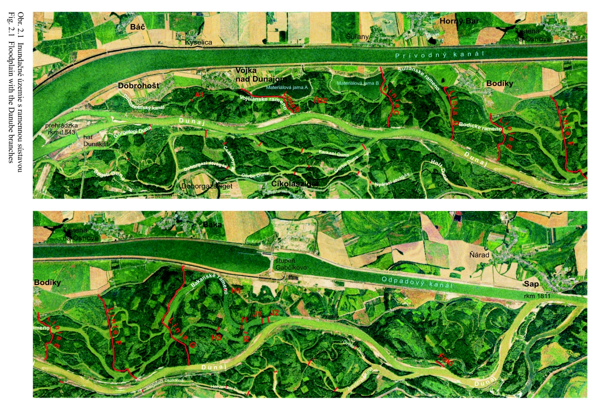
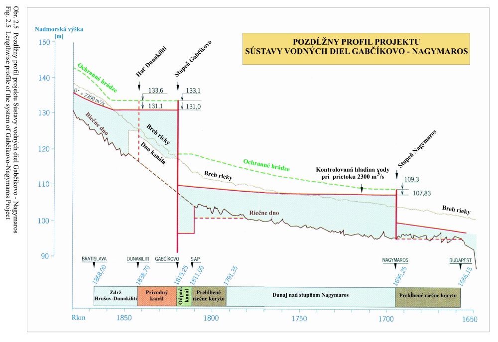
The main hydrological function of the floodplain (inundation area between the flood protective dikes) is to transfer the peak flood discharges, and to protect the areas behind the protective dikes from flooding on Slovak and Hungarian territory. The next function is that of a natural polder, whose task is to store a part of the water from the maximal flood discharge in order to reduce the peak maximum flood discharge downstream the Danube. These two flood protection functions have the absolute priority. It was the main reason why, when conceiving the Gabčíkovo project, the floodplain zone in this stretch of the Danube was preserved, and why the by-bass canal was constructed outside of the floodplain, behind the left side old protective dikes (Fig. 2.1).
In conformity with this hydrological priority the ecological viewpoint is obvious. It is necessary to preserve the specific hydrological properties of the floodplain between the flood protective dikes and the aquatic and terrestrial ecosystems typical for functioning floodplain as well as its numerous characteristic biotopes and ecotopes. In this sense, the within-dike zone is understood as a system in which the biota represents the central point of interest. Further decisions about modification of hydrological regime within the territorial extent of the within-dike zone are considered to be decisive criterion from the ecological short-term, as well as from the long-term aspects. From the viewpoint of the ecosystem, it is typical that the floodplain is flooded more or less regularly, depending on the flow rate in the Danube. It is also obvious that, in regard to the preceding development of the riverbed depth, the floods are less frequent than could be expected according to flow rates in the Danube. It is also obvious that in consequence of this, the water levels in the old Danube are lower at present and, in addition, that they are reduced due to transferring a portion of flood water through the by-pass canal. If the floods and level of floodwaters have to be typical in the within-dike zone, it is evident that they should occur more often and the water levels have to be higher, namely, up to heights, that corresponded in the past to the water quantities flowing through Bratislava at the time of floods. At present, it is necessary to help by flooding the floodplain, and to increase the water levels artificially during flooding. This can be done by increasing water level (impoundment) in the Danube old riverbed, by supplying the floodplain zone with water, and by different modifications in the arm system, for example, by regulating the water levels on cascades between the arms and by rearranging the system of river branches. As to the dependence of flow rates in the arms on the flow rates in the Danube, the optimal way to improve the existing state is using a natural auto-regulative mechanism. The human interventions are, however, acceptable in critical or special cases.
Besides the hydrological flood protective function, the preservation of specific aquatic to terrestrial ecosystems typical for the functional floodplain, which would spontaneously converge to the natural state, belongs to the priority at this territory. At the same time, it supports fulfilling of the flood protective function of this territory and vice versa.
In respect to the primary position of vegetation in the natural or nature close ecosystems, it is necessary to stress that the floodplain ecosystem is very dynamic from the viewpoint of flora and vegetation, but, on other hand, also highly adaptable. Even short-term changes in the hydropedological regime (floods, depth of flowing and stagnant waters, slope of arms, ground waters level, physical and mechanical properties of soils, etc.) trigger changes in vegetation structure. These changes are very fast and range from one year (annual littoral phytocoenoses), to several years (wetland vegetation), and 10-20 years at the vegetation of moist and humid types of floodplain forests. At the same time, these changes and adaptations do not exceed the general variability range of the floodplain forests, but run exclusively within them. Hence, these changes have a quantitative nature. Changes of quality, i.e. extinction of a vegetation type or a plant population occur only exceptionally. It was illustratively demonstrated by prognoses of changes made already in connection with the Gabčíkovo-Nagymaros project (Jurko 1976) or the Wolfsthal dam project (Šomšák 1994). In both cases, it was stated that the expected changes would have only a relative character. It means that where the ground water level would decrease, the drier types of floodplain forest would appear, and vice versa. However, the changes in hydropedological regime cannot exceed the existential limit of vegetation of floodplain forests (permanent drying, permanent flooding of ecotopes). Such a state began to be observed since early 1970s (regulation of the Danube inclusive of deepening its riverbed) up to the Danube damming in October 1992. Then, in May 1993, the supplementary system for supplying the floodplain river arm system with water was put in operation.
In respect to extraordinary dynamics, and, at the same time, high adaptability of vegetation in floodplain area, it is difficult to define and ideal - optimal hydrological regime. Based on the predominating opinions of most experts, the hydropedological conditions existing in 1950s and at the beginning of 1960s, when about 70% of vegetation of this territory consisted of natural or quasi-natural phytocoenoses, can be considered optimal for the Danube floodplain, the zone between the flood protective dikes (Fig. 2.1).
From the point of view of forestry, it is, of course, possible to speak about the same woody plants, which form the plant communities - ecosystem edificators. However, the deciding criterion is timber production. Another criterion is a state of good health for forest trees and whole stands (Varga et al. 1997). An extraordinarily significant indicator of the health of forests is a change in the forest tree foliage (Oszlányi 1995, 1996, 1999).
In the past, the within-dike zone was an object for interest of hunters, anglers, tourists (walkers and cyclists), as well as other visitors, searching for bathing and water sports possibilities. After 1999, still before finishing the Gabčíkovo project, but already under new conditions of ownership relations, several development projects were elaborated for the territory between the old Danube and the by-pass canal. Their aim was to search for solutions involving further development of this territory with regard to its unique natural values. At present, individual forms of recreation prevail here. Opening of the Slovak part of the international cyclist rout (in 1995), which uses Gabčíkovo project dikes (reservoir and by-pass canal) and also old flood protecting dikes, improved tourism and recreation possibilities.
4. nature and Landscape Protection - starting points and limits for
new solutions
Act No. 543/2002 defines nature protection as "limiting of interventions, which can endanger, damage, or destroy life forms and their conditions, nature heritage, appearance of landscape and reduce its ecological stability, as well as relieve of impact of such interventions. Nature protection also includes care of ecosystems.
The water regimen is the basic abiotic factor limiting the functioning of the floodplain ecosystem. In spite of the fact that supplying the river arm system with the water, using the intake structure at Dobrohošť, offers inflow of sufficient water for some components of biota, it does not assure a sufficient dynamic of water levels, erosion, and accumulation processes in the within-dike zone. The present artificial, water regimen does not follow the natural range of water level fluctuations. During simulated floods, water overflows the terrain only locally. Stagnant or slowly flowing water does not cause erosion, does not transport and subsequently deposit material (suspended solid, sand and gravel, decaying organic substances in the form of detritus and debris), and these natural processes are not in balance there.
After the change of water regime, the most conflicting factor from the viewpoint of nature protection is forestry (silviculture). In this area, regarding natural conditions, the softwood floodplain forests are cultivated. Since 1950s, the original stands of the association Salici-Populetum are replaced after clear-cutting almost exclusively by monocultures of hybrid poplars Populus x canadensis and other cultivars.
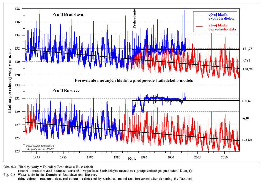
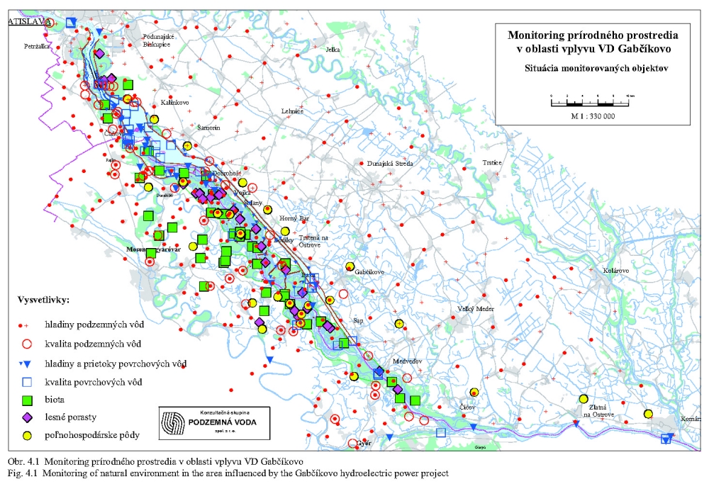
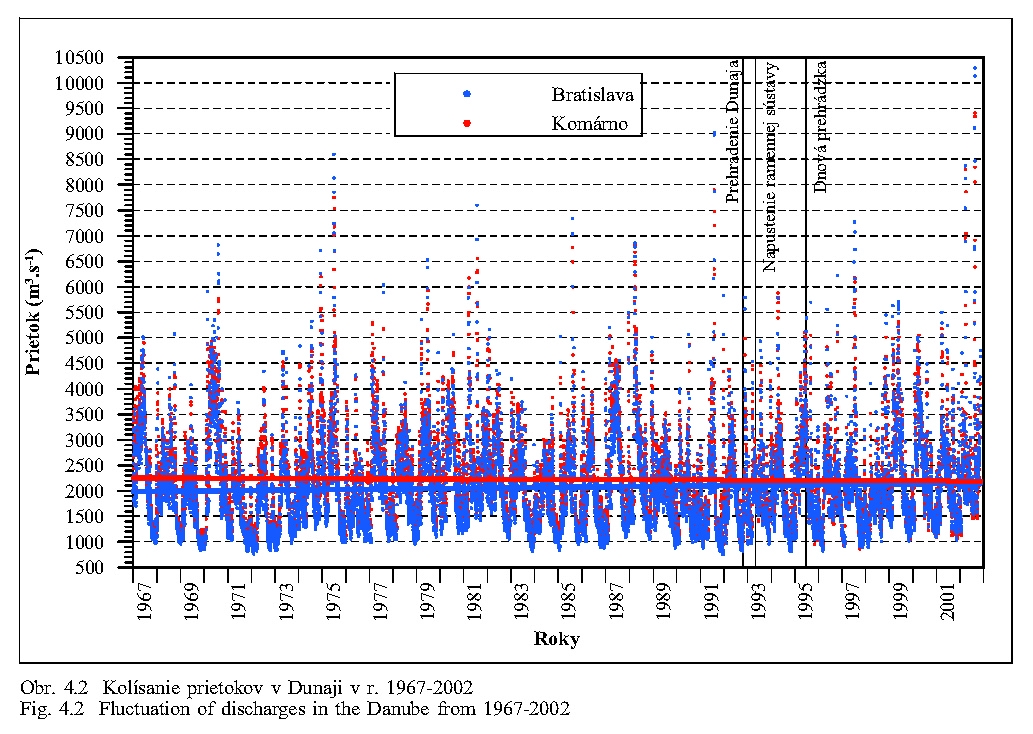
The water levels and flow rates were measured on several stations (Fig. 4.1). The Fig. 4.2 shows fluctuations of flow rates in the Danube at Bratislava and Komárno. The regression line shows that the long-term changes in flow rate are, at least at Bratislava, negligible. The average annual discharge at Bratislava is 2025 m3/s. The lowest measured discharge was 570 m3/s, the largest one 10 400 m3/s (10390 m3/s at Bratislava-Devin in August 2002). The expected discharges with occurrence probability once for 100, 1000 and 10,000 years are 10,600 (after flood in 2002 this value was corrected to 10,000 m3/s), 13,000 and 15,000 m3/s, respectively.
The maximal discharge in August 2002 at Bratislava-Devín was 10,390 m3/s, at Medveďov 9,420 m3/s and at Budapest 8,250 m3/s. The difference of 2,140 m3/s between Bratislava-Devín and Budapest was not caused by a break of dikes and flooding a territory as happened in 1954 and 1965. Downstream of Gabčíkovo, the rivers Váh, Hron, Ipeľ and some other smaller tributaries on the Slovak and Hungarian side mouth into the Danube. At the time of the flood they also had increased discharges. The difference between the maximum flood discharges between Bratislava (together with the discharges of its tributaries) and Budapest represents the decrease of peak flow due to the anti-flood conception of the Gabčíkovo-Nagymaros Project. Ground water storage played also an important role here.
The water sources for floodplain are as follows: first of all the Čunovo dam with the hydroelectric station allowing an discharge of 400 m3/s, the regular weir and the weir in inundation at Čunovo (the discharge through the Čunovo dam can be continuously regulated up to the value of 11,200 m3/s); intake structure into the Mosonyi Duna with a capacity of 40 m3/s (a part of its water also supplies river arms on the Hungarian side); intake structure at Dobrohošť with a capacity of 200 m3/s; and the water seepage from the Čunovo Reservoir which is estimated to 30-50 m3/s. Impoundment of water level in the old Danube (for example as at Dunakiliti) offers to the floodplain river arm system water flowing in the old Danube. Impoundment would additionally increase the ground water level. According to International Agreement of 1995 (Agreement 1995), the minimum and maximum discharge through the Čunovo dam is 250 and 600 m3/s, respectively.
Before the closing and separation of the arms from the Danube, hence still before the concentration of all water into the Danube main stream, but already after straightening the Danube, and after construction of the flood protection dikes, the water continuously flowed throughout the arms on the Slovak and Hungarian side, even in the periods of low flow. The data about this are preserved in the publication of Mucha, Dub (1966), Tab. 4.2 and Tab. 4.3. The basic data about the flow rates are illustrated in the Table 4.4. For comparison with the levels, when the arms were permanently through flowing (Tab. 4.2 and Tab. 4.3), we also give the typical discharge situations in the arm system from the later period, when the arms were closed and, as the matter of fact, separated from the Danube (Tab. 4.5). Some discharge situations, mainly at lower discharges, can repeat several times a year.
The following conclusions can be derived from the above tables:
|
Before the fortifying and raising of the Danube banks and before the closing of the river arm inlets (before 1962), the water flowed in the arms at any water level in the Danube main stream; in some places the water flowed into the arms and on other places flowed out from them, on both the Hungarian an Slovak sides. In the main river arms the water never stagnated. |
|
|
Before putting the Gabčíkovo project into operation, but already at the state of the Danube riverbed in 1980, the water flowed in almost all arms only when the discharges in the Danube exceeded 3,500 m3/s. Such a situation occurred only about 17 days a year (CEC 1992). In some main arms, the water flowed when the discharges in the Danube exceeded 2500 m3/s. Such a situation lasted only about 3 months a year. The state immediately before 1992 was probably a little worse than that described by the CEC report. |
|
|
The typical high discharges occurred in summer, mainly in June and July, when the water flowed in the majority of larger arms, in the pre-dam period. |
|
|
The typical low discharges occurred in October, November and December, when the water usually did not flow and stagnated in a part of the arms, while some other parts of arms were dry (state before 1992). |
|
|
The ratio of the maximal average monthly discharge in summer and the minimal average monthly discharge in winter in the Danube is 1.93. The discharge in summer is about twice as large as in winter Tab. 4.3. |
|
|
The regime of water flow in the arms always depended on flow rates in the Danube. This was influenced by fortification of the Danube riverbanks, height of the bank spillways and inlets of original arms, as well as by the level of the Danube bottom. |
|
|
Similarly, the ground water level, mainly in the river close zone, but also in a wider territory, always depended on the water level in the Danube and was influenced by the water level in the arm system. |
The occurrence probability of discharges in the Danube exceeding 4,000 m3/s is important for the water regime in the floodplain. According to Tab. 4.5 this value represents discharges at which the water is flowing in almost all arms. In the Slovak side arms, it corresponded to discharges of about 60-70 m3/s in the pre-dam conditions. Holčík (1992) states that in the past the whole within-dike zone was flooded at the discharges of 4500 m3/s. Table 4.6 presents maximum monthly discharges in the Danube at Bratislava. The discharges exceeding 4500 m3/s are made expressive. The table shows that the highest discharges are expected in July and August, rather than in March, whereas the lowest discharges are expected in October and November.
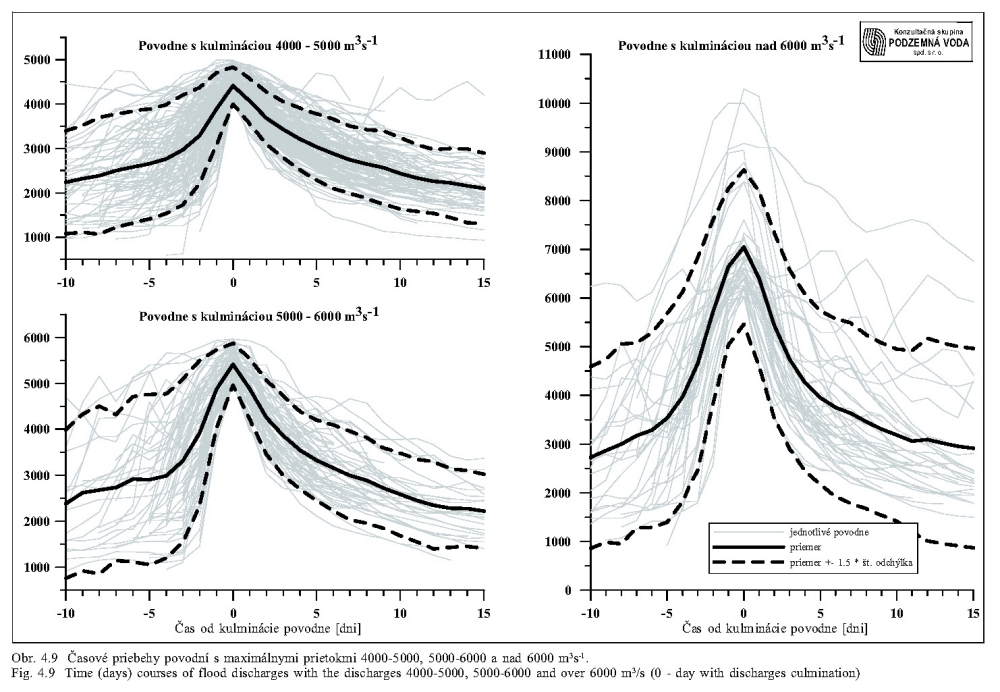
For flood flow rates measured at Bratislava diagrams were constructed. The course of floods is represented in Figure 4.9 as lines of discharges in time. They show that they are very steep at the beginning. At the same time these curves also define the course and duration of floods for a concrete state of the floodplain and the Danube banks. These data, plus some data in further tables and figures, represent the auxiliary data for simulating the natural flood in the flood plain system. The figures show that the beginning of Danube floods is about twice as fast than their fading away. In the arm system, the beginning increase of water levels during floods, the increase of water levels occurring mainly after over-spilling the riverbanks, will still be faster and the decrease of water levels after floods will be slower.
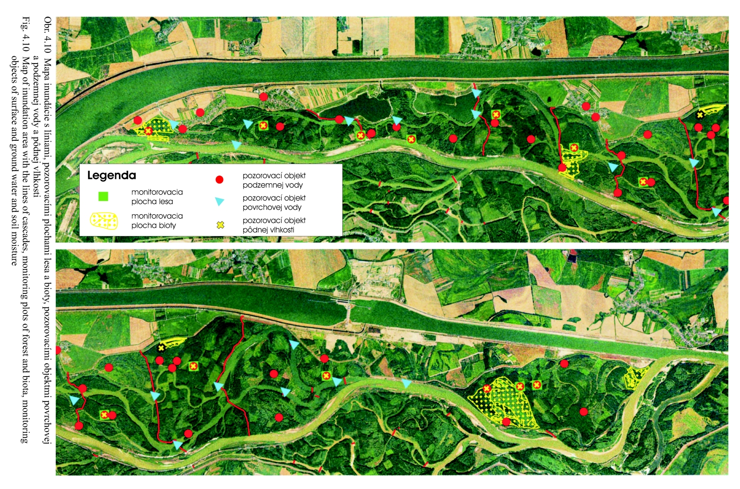
Low cascade dikes, forming a series of blocks across the within-dike zone, regulate the water level in the floodplain river arm system. In the dikes there are sluices for the regulation of the water level (Fig. 4.10). These lines of cascade dikes (A to J) are raised, fastened forest ways, built up in the past, and they are inconspicuous in the terrain. The water level at the cascade dikes, which are often situated in the places of previous dikes, were established so that the water levels correspond approximately to the water levels recorded around the year 1960.
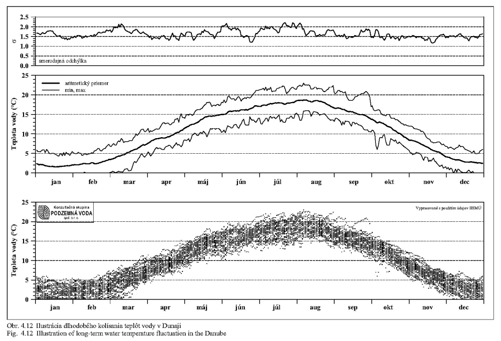
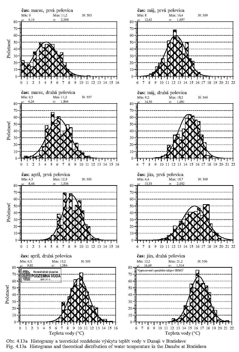
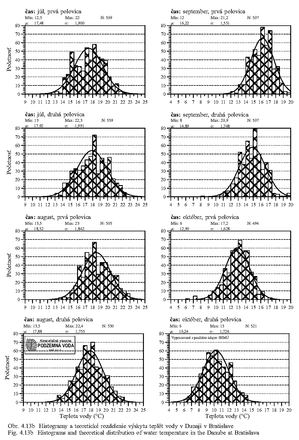
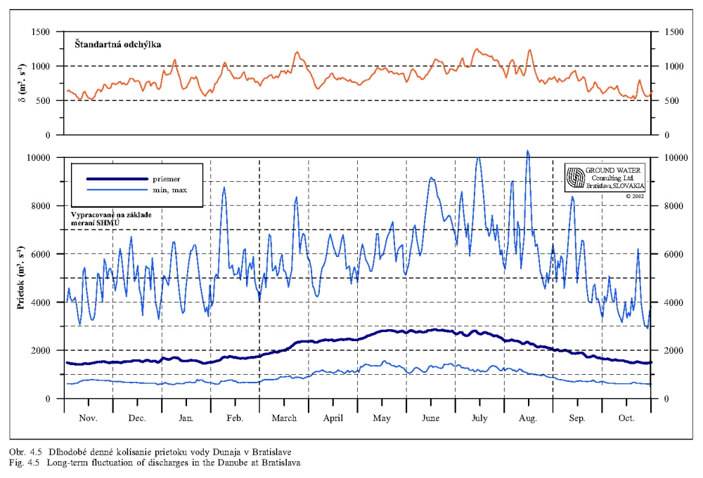
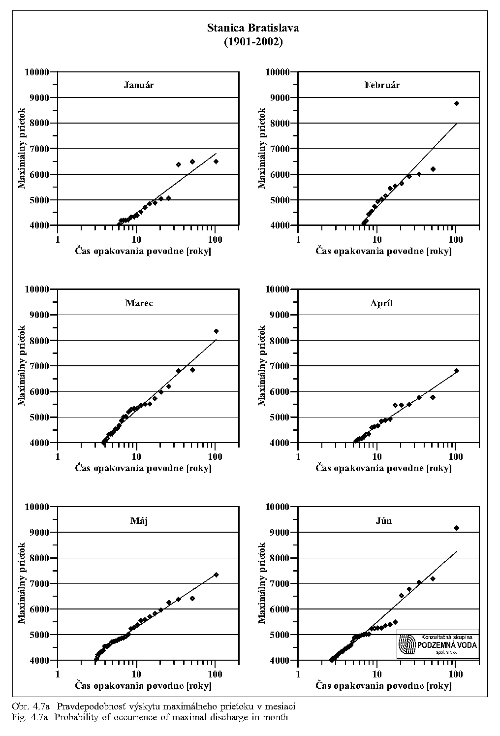
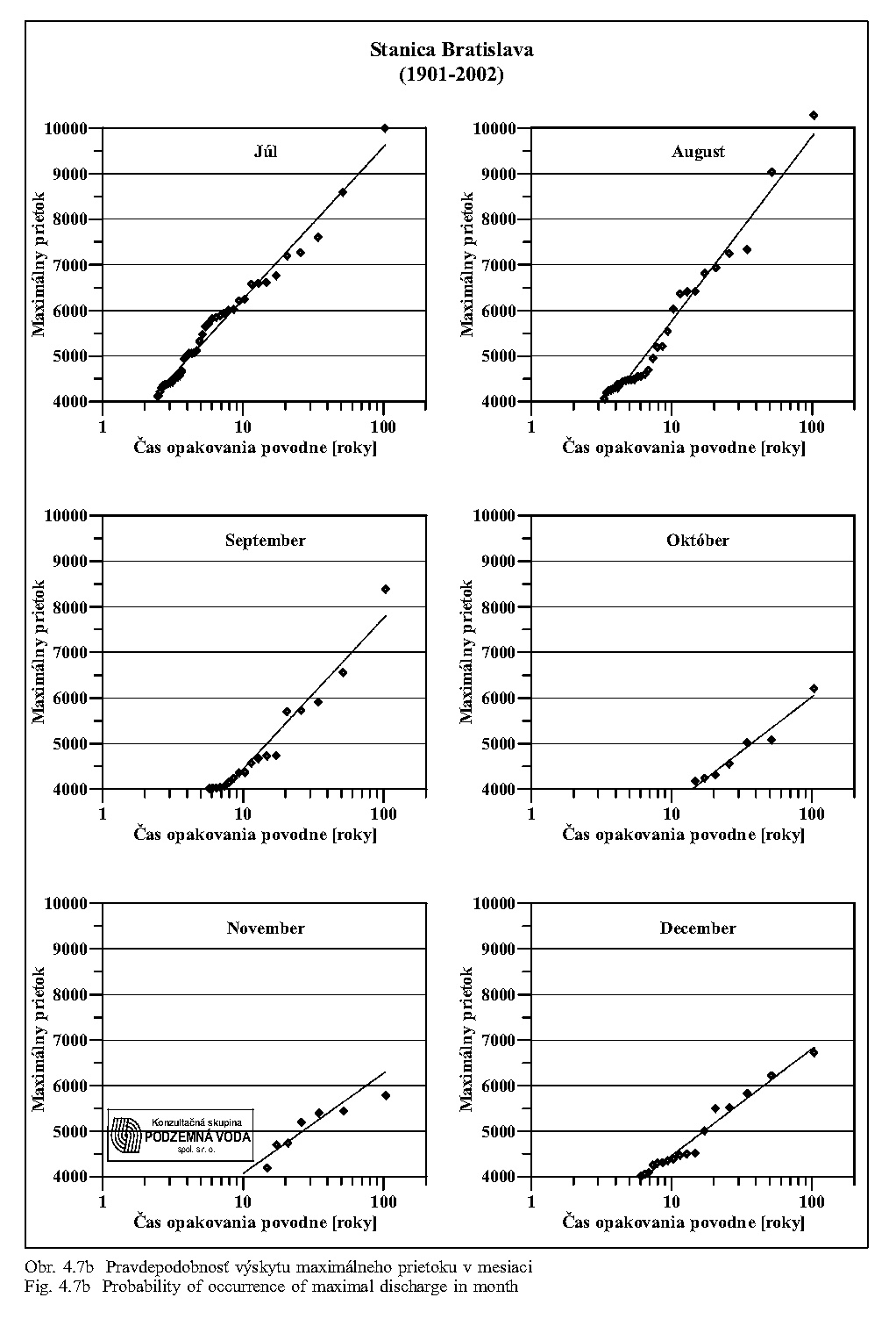
Water temperature is an important ecological factor influencing management of simulated floods. Fig. 4.12 shows, in a long-time scale, the daily fluctuations of water temperature in the Danube at Bratislava (Mucha et al. 1994). This figure shows a close correlation of the temperature with the calendar date. Figure 12, Figure 4.13a and Figure 4.13b shows, for example, that water temperatures of 10°C occur in the Danube on average around 20 April with a possible dispersion from 22 March to 15 May, when the average flow rates are, according to Fig. 4.5, about 2,500 m3/s, minimal discharges ranges from 1,000 to 1,500 m3/s and the flood discharges could reach almost 7,000 m3/s. Expected probability of flood occurrence is given in Fig. 4.7a and Fig. 4.7b.
Flood discharge is defined as a discharge exceeding the value of 6,000 m3/s at Bratislava. This corresponds to the 1st degree of the flood protection activities. In case that there is in the Danube a higher discharge that can pass via the by-pass canal and Gabčíkovo hydroelectric station, surplus water is discharged into the old Danube and its inundation. The Gabčíkovo project has been projected to stand the 1,000-year water discharge without endangering the flood protection and prescribed flooding security. It corresponds to the discharges reaching at Bratislava 13,000 m3/s. The maximal (total) discharge capacity of the Čunovo dam structures in the direction towards the Danube floodplain within-dike area amounts 11,200 m3/s [Vodohospodárska výstavba š.p. 2000 p. 61, (Provisory management regulation)]. This is the discharge, which is to be taken into consideration in the old Danube and its floodplain. The maximum discharge of 8 turbines of the Gabčíkovo hydroelectric station amounts 3,800 m3/s under conditions that in the Danube at Bratislava discharge reaches 10,000 m3/s and it declines at the higher discharges. At a 1,000-year flood with discharges of 13,000 m3/s in the Danube, the discharge through the Gabčíkovo hydroelectric station decreases to 3,160 m3/s. If the navigation locks are open, they allow releasing additional discharge of 2,800 m3/s. In such a case, the by-pass canal is able to lead in total a discharge of 4,000-4,500 m3/s. The discharge trough of the Gabčíkovo power station depends on the number of active turbines, discharge through the navigation locks, as well as on the water level downstream of the station, which is at present higher as projected.
Let us repeat that the real maximum discharge that is to be considered in the old Danube and in the within-dike floodplain zone with its arm system moves around 11,200 m3/s. It is a short lasting discharge of the flood culmination. However, the lower, but long-lasting discharges are also dangerous, as shown by the flood in 1965. The real discharge in the old Danube at a 1000-year flood can be estimated and expected to be 10,300 m3/s.
For flood protection in winter, regulation of discharges into the old Danube, the middle weir of the Čunovo dam is used. In co-ordination with the Dunakiliti dam, it allows suitable velocity of water flow and passing the ice floes. Freezing of water in the old Danube is not expected, because the old riverbed is supplied with the warmer ground water in winter.
The diverting of flood discharges through the floodplain must be done under the condition that the level of the floodwater should not exceed the level that would have been reached without construction of the Gabčíkovo project. It means that in any possible alternative it must be calculated with discharge in the Danube at Bratislava minus 3,000-4,000 m3/s flowing through the by-pass canal (under the presumption that the turbines are working and the locks are open). At present, without regulation of the Danube riverbed downstream of Gabčíkovo in accordance with 1977 Treaty, the function of turbines is substantially limited at the discharges exceeding the 100-year Danube water discharge.
In order to obtain an adequate picture of a flood situation, let us assume the following hypothetical but realistic consideration. Assume that a discharge of 10,000 m3/s can be released through the Čunovo dam during the hypothetical 1000-year flood (possibly a larger flood as 1000-year flood occurred in the year 1501). Then we assume, that the discharge capacity of the Danube old riverbed, floodplain, and its arms, should be close to the state existing during the flood of 1954, of course, with better flood protection measures inhibiting seeping and breaking of dikes. The situation that would arise under such circumstances can be seen in the example of the flood of 1965, when about 90,000 ha were flooded, 693 houses were destroyed and 3,170 houses were damaged in Hungary by increase and seepage of ground waters above the surface, and this in spite of the fact that the dikes withstood the load (Hronec, 1969). We stress again that the dike on the Hungarian side did not break in 1965. And still the discharge in 1965 in the Danube did not reached 10000 m3/s.
If the discharge capacity of the old Danube will be in the state, which existed before 1992, it will have such carrying capacity. If the water level in the old Danube would be impounded, e.g. by underwater weirs, they must be constructed in a way not to increase water level during the floods. If the old Danube riverbed would be narrowed or partially grown by vegetation, it is necessary to find a method to lead more water through the river arms and over the floodplain surface.
Theoretically it is possible to increase the discharge capacity of the river arms. The more we would wish to increase the discharge capacity of the main river arms, the more we would have to dredge their bottom, widen the arms and fortify their banks. It is impossible to form a meandering arm, which would be able to take the whole required flood discharge. The hydraulic gradient of such meandering arms would be half of the gradient in the old Danube. The flow velocity in such arms would be considerably lower. The discharging profile of the meandering arms should be considerably larger than that of the old Danube in 1992. Such an arm or new meandering Danube would be neither natural nor the Danube.
Part of the floodwater can flow over the floodplain surface. From an ecological viewpoint there are no objections against an increase in the extent of meadows maintained by mowing or grazing. By means of modelling, it would be possible to find the most suitable spaces ("hydraulic corridors") for leading water during the flood. They would be deforested and maintained in such state. However, we cannot use for this purpose the stands growing on the arm banks, because they play a role of bio-corridors and shadow the littoral. There are principal objections against the so-called hydraulic forests (sparse canopy and removal of shrub stratum). Leading of the water over the floodplain surface means that a part of this floodplain must remain without tree vegetation and the terrain must have a corresponding declination to lead large water amounts. It is also necessary to accept erosion of the terrain surface. The old Danube is ready to take such a function over.
Limiting factors of further considerations
The first limiting factor is the maximum flood discharge, which should pass through the floodplain. Its water level should not exceed the levels occurring in the pre-dam conditions. The second limiting factor is discharge in the old Danube and its regime. The natural regime was as follows: The average low discharge in December is approximately the half from the average high summer discharge in June, Tab. 4.4. This relation should be preserved in a way that considerably more water will flow in the old Danube during the growing season than in winter. According to the Slovak-Hungarian Agreement of 1995 (Agreement 1995) such discharges correspond at present to the minimum of 250 m3/s and maximum of 600 m3/s. The discharges may include all water that cannot be passed through the by-pass canal. The Hungarian side (December 1999) defines the ecologically minimal discharge in the growing season as 400 m3/s and in winter considerably less. On the other hand, at discharges exceeding at Bratislava 4,000 m3/s and not reaching 6,000 m3/s, the water level in the arms and in the floodplain should reach the values occurring here in the pre-dam conditions. It means simulation of flooding the floodplain in relation to discharges in the Danube at Bratislava. Based on the present experience, the Hungarian side intakes about 130 m3/s water from the Danube into its arm system though it could intake considerably more. Similarly, the Slovak side supplies its arm system usually by less than 100 m3/s. At the beginning, we can assume that about 200 m3/s water can be put into the arm systems on both sides without the necessity to build up and fortify the main (meandering) arms. The discharges in the arms can be gradually increased. A total discharge of 400 m3/s can be taken as a desirable value, which can be, but inevitably must not be achieved. However, such discharge will need regulation of the banks and dredging of the bottom, in case we create a unified system of a single meandering new riverbed. If we do not create such a system, but we reconnect the arms with the old Danube riverbed, the discharges into the arms may considerably differ in individual stretches of the old Danube riverbed and its arms. The discharge of 400 m3/s can be accepted as a limiting discharge for the arms in the growing season. It can be reached gradually, more in a natural way, and it must not be reached at once, by means of regulation and dredging of the present existing arms. Any larger discharges in the arm systems would require expensive works, whose results might contradict ecosozological concepts, because they would require creating a riverbed profile and fastening of banks, that would correspond to the pre-dam Danube at low water discharges.
Requirements of the flood protection measures are evident from the previous data. If not, a completely new riverbed for the Danube should be realised, than the old Danube riverbed together with the floodplain surface, within the protective dike zone, must allow to lead that part of the discharge, which cannot pass through the floodplain arms - a new Danube riverbed (new eupotamal). In such a case, the old Danube riverbed must be maintained in such a way, which assures existence of the same discharging profile as in the pre-dam conditions. In the case of solution without the water table impoundment, it means a regular removal of spontaneous growth. In the case of solution with water level impoundment to a level covering the whole riverbed (a state which corresponded to discharges of 1,000 - 1,300 m3/s in the pre-dam conditions) it means only a minimal cleaning and maintaining of the old Danube riverbanks.
In the case that the old Danube overtakes the function of leading the flood discharges, there will be minimal requirements to the arm system in connection with the flood protection measures. As the matter of fact, they will be almost the same as at present. Probably, some minimum terrain regulations will be necessary in selected places along the banks of the old riverbed. It also applies when discharges into the arms will be a little higher. However, any such proposals must be verified by means of numerical modelling.
In the case that the old Danube should not be preserved in the pre-dam form (for example partial raising and narrowing of its river bed), than it is necessary to find a new space for leading the flood discharges in the area between the right- and left-side flood protection dikes. The proposal must be verified by means of modelling and subsequently realised before starting to raise the old river bed and before its natural terrestrialization.
5. State of the nature environment 10 years after the Danube damming
When speaking about the influence of the Gabčíkovo project and the underwater weir at Dunakiliti on environment and nature, it is clear that the main role is played by the ground water level fluctuation in the geological profile of aquifer. It determines the capillary height and changes in availability of the ground water for the soil and root systems of plants. For agriculture it is important, first of all, whether the ground water level reaches sediments showing a good capillary elevation.
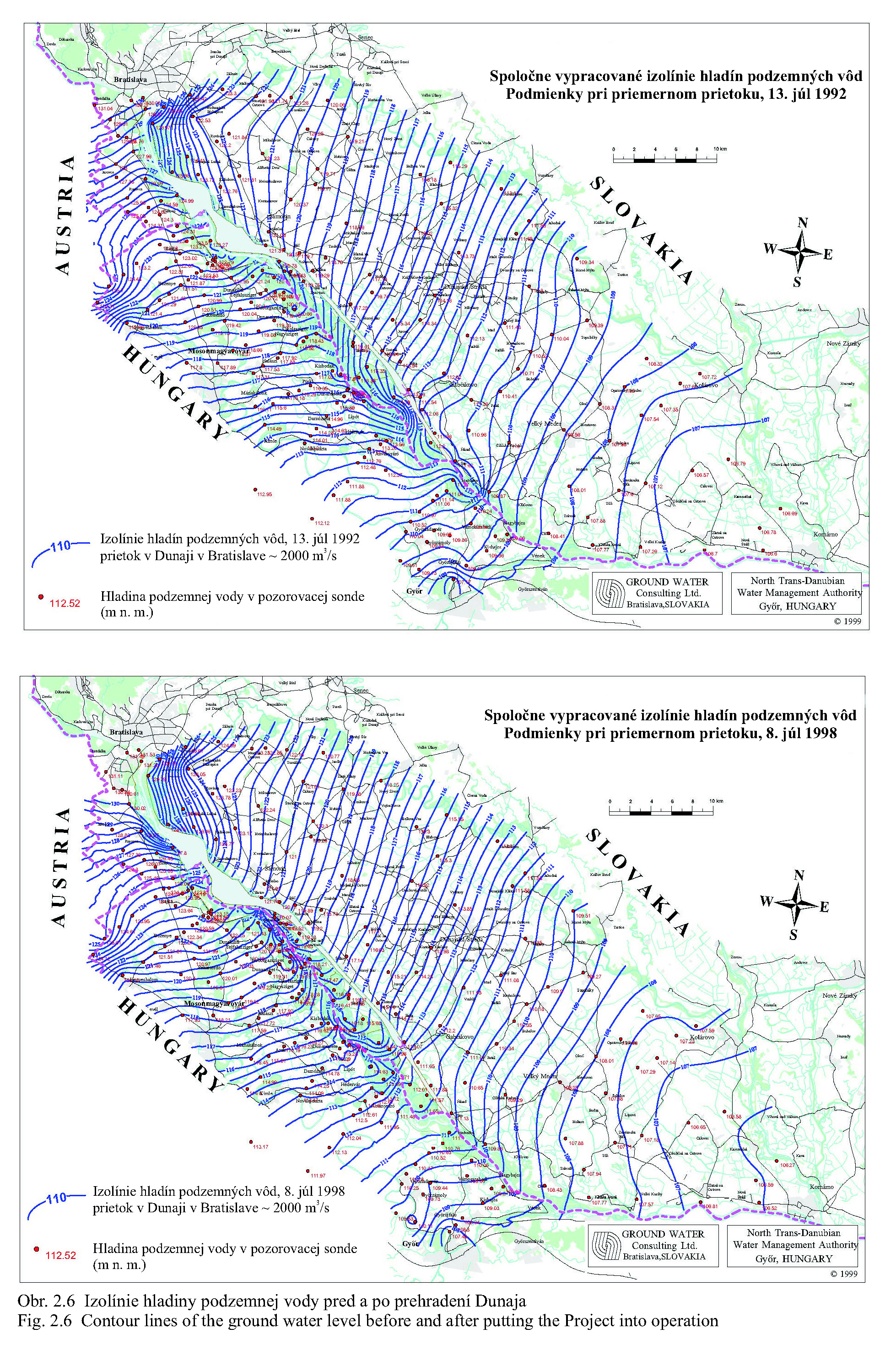
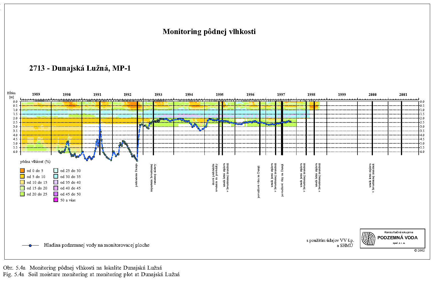
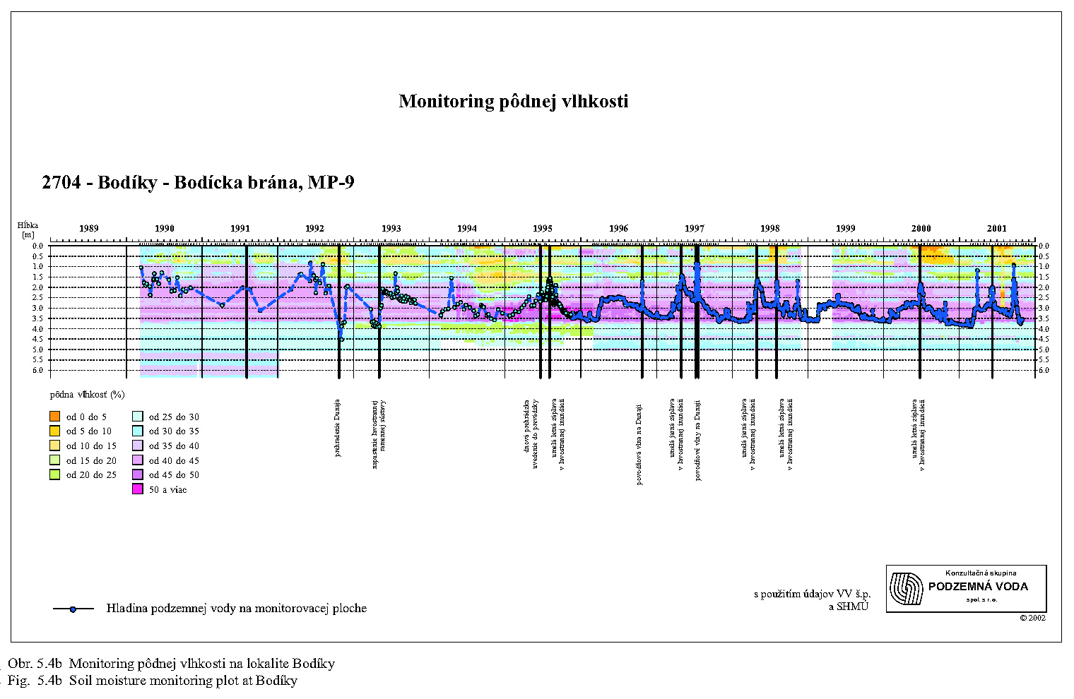
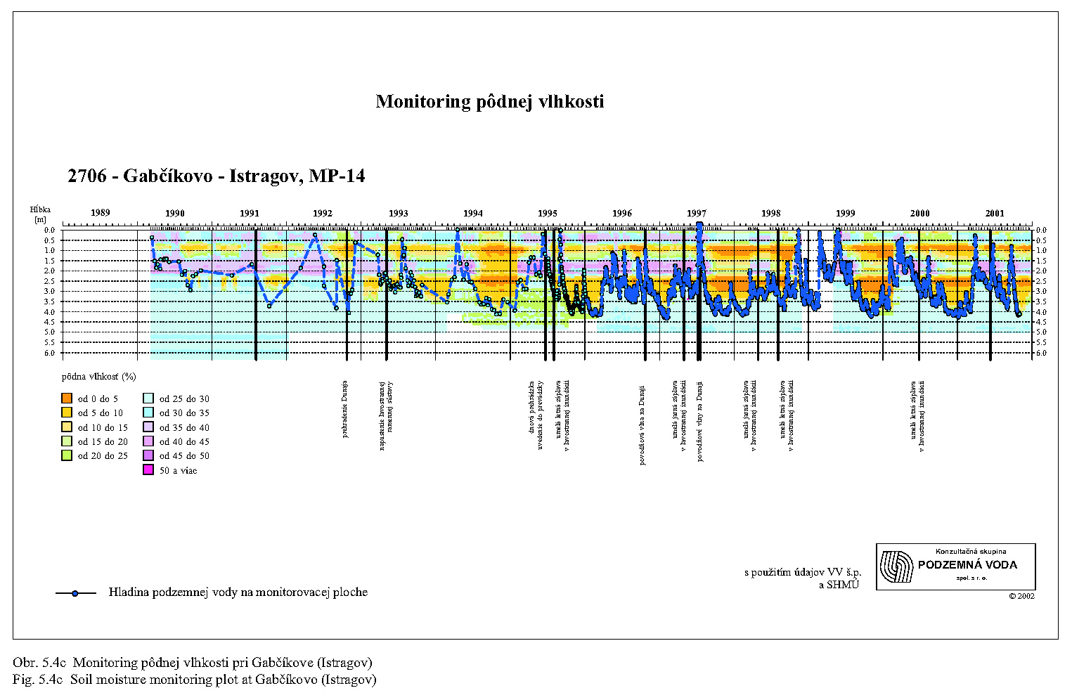
In the territory of Szigetköz and Žitný Ostrov Islands the depth of border between the gravely stratum and covering fine sediments or soil is an important factor for interaction between the ground water and soil moisture. It is optimal for agriculture, when the ground water level in the growing season reaches the fine soil sediments. A high level of ground water and its fluctuations in the floodplain are welcome, because such a state is suitable for the typical alluvial biotopes and is naturally regulated by the river arms. The ground water level directly influences the soil moisture, especially in the vegetation period (Fig. 5.4a, Fig. 5.4b, Fig. 5.4c).
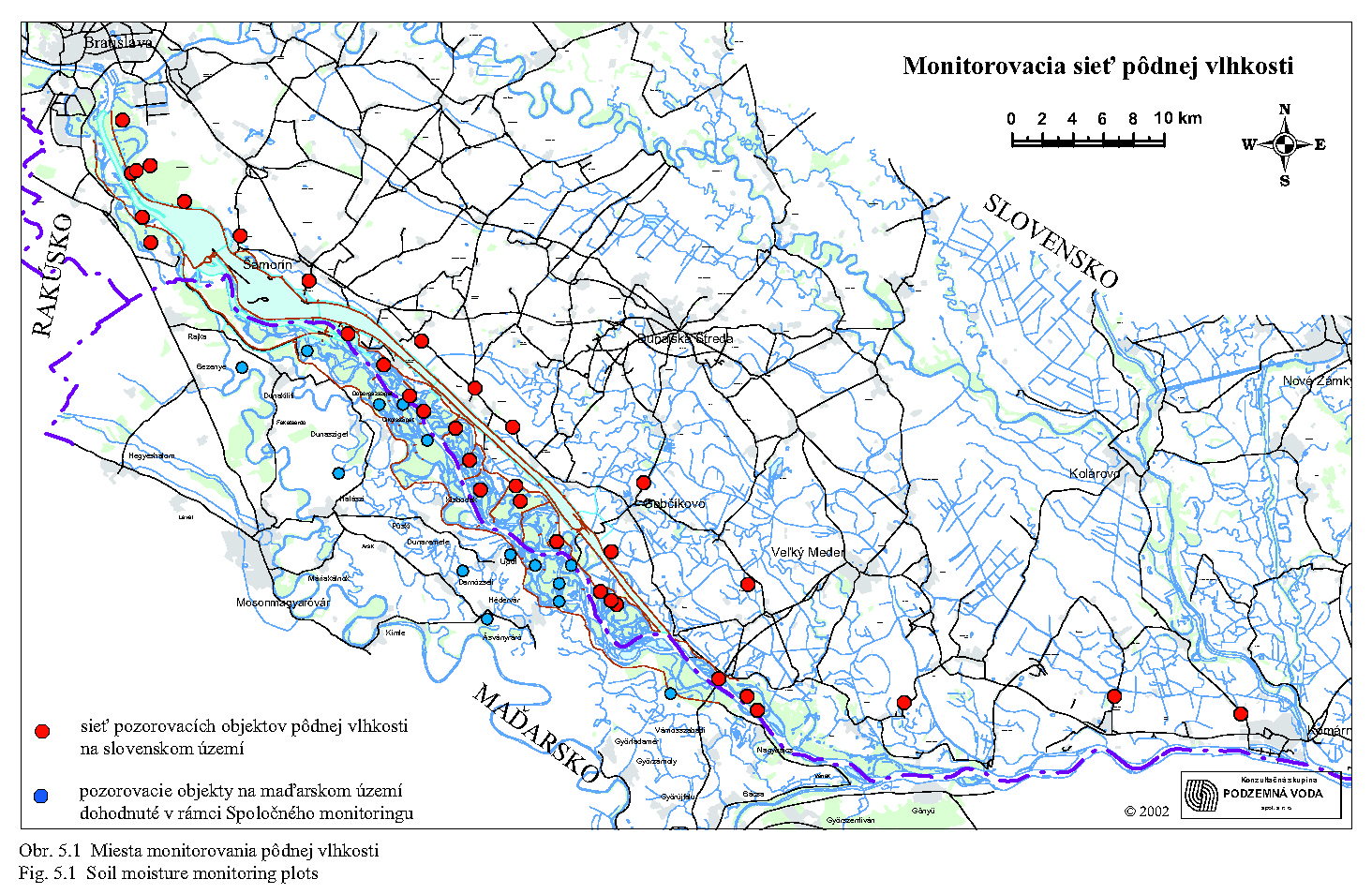
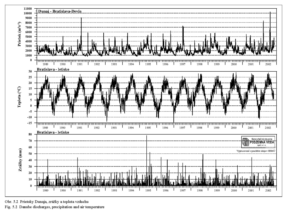
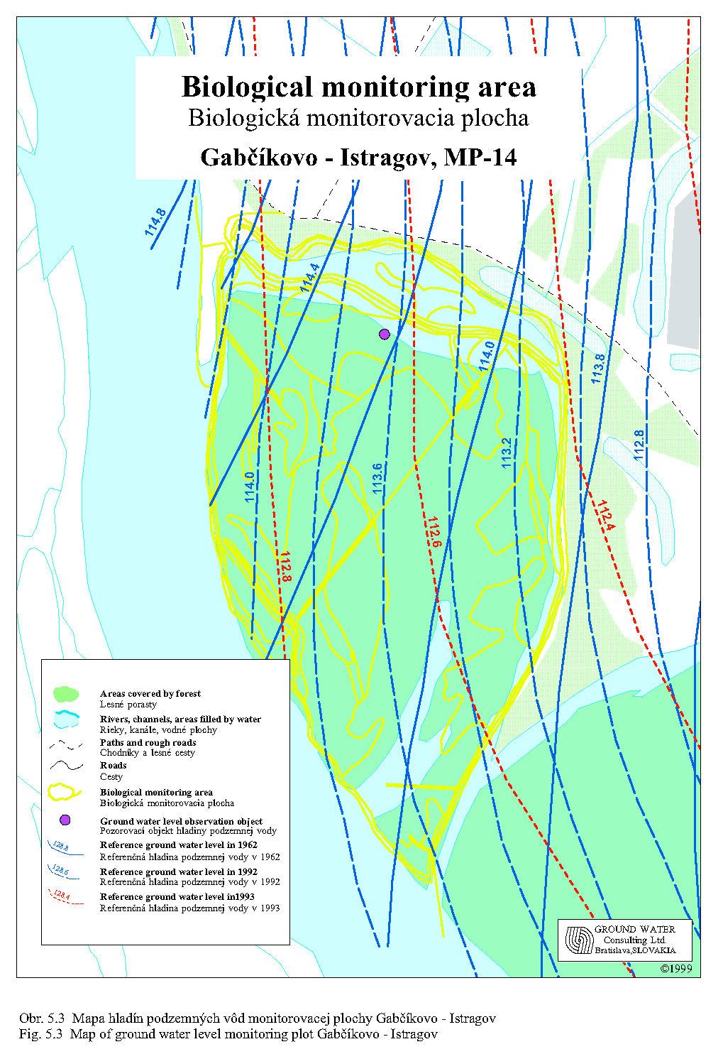
The soil moisture (Fig. 5.1) is influenced mainly by the water level in the Danube, in river arms, by precipitation and air temperature (Fig. 5.2). For each monitoring plot, a map in the scale of 1:10,000 has been elaborated. The equipotential lines represent the ground water levels in the years 1962, 1992 and 1995 (Hlavatý, Cambel 1995), (Fig. 5.3).
In order to emphasise the time and depth relationships of soil moisture, diagrams, in which the abscissa represents time, the ordinate depth, and the humidity levels are expressed by colour, have been elaborated (Fig. 5.4a, Fig. 5.4b, Fig. 5.4c). The brown shadows express the moisture deficiency and inaccessibility for the plants; the green and blue colour means sufficient soil moisture; while the violet shadows express high soil moisture and soils fully saturated by water (usually below the ground water level). Ticks at the upper scale of the diagram mark time of measuring. Fluctuation of the ground water level is plotted in the same depth scale. The diagrams show a strong influence of ground water level fluctuations on the soil moisture. Besides this, it is possible to recognise impact of precipitation or irrigation, seasons with a high evaporation, and to draw the general conclusions about changes in soil moisture. It can be seen, how the soil moisture reflects the geological profile, structure of sediments and influence of the capillary barrier. The "moisture" measured under the ground water level reflects individual strata porosity and proportion of fine-grained material. Among the data, the dates of the Danube damming, supplying of the Slovak part of the arm system with water and beginning of supplying the Hungarian river arms with water are set off.
Ecological conditions of the floodplains are in addition determined by a sufficient input of nutrients. Nitrogen, phosphorus, carbon, hydrogen, oxygen, and sulphur belong to the most significant nutrients for the water and soil organisms. The main role is awarded to phosphorus and nitrogen. Out of these elements, potassium, calcium, magnesium, iron and manganese are necessary for water organisms. Less significant are zinc, copper, cobalt, some organic complexes, vitamins and other substances. Conditions could be evaluated also from the viewpoint of plant and timber production, for which the macronutrients like carbon, hydrogen, nitrogen, phosphor, sulphur, potassium, magnesium and micronutrients like iron, and manganese, zinc, copper, boron and molybdenum are significant. In this connection, the simulated flood creation of quasi-natural conditions is emphasised.
Most elements and compounds are naturally present in the Danube water in sufficient quantities and are not a limiting factor for survival of water organisms. The total nutrition value of the water (water nutrition potential) is determined not only by the sufficient quantity of the nutrients, but also by their mutual proportion, mainly by the phosphor/nitrogen ratio.
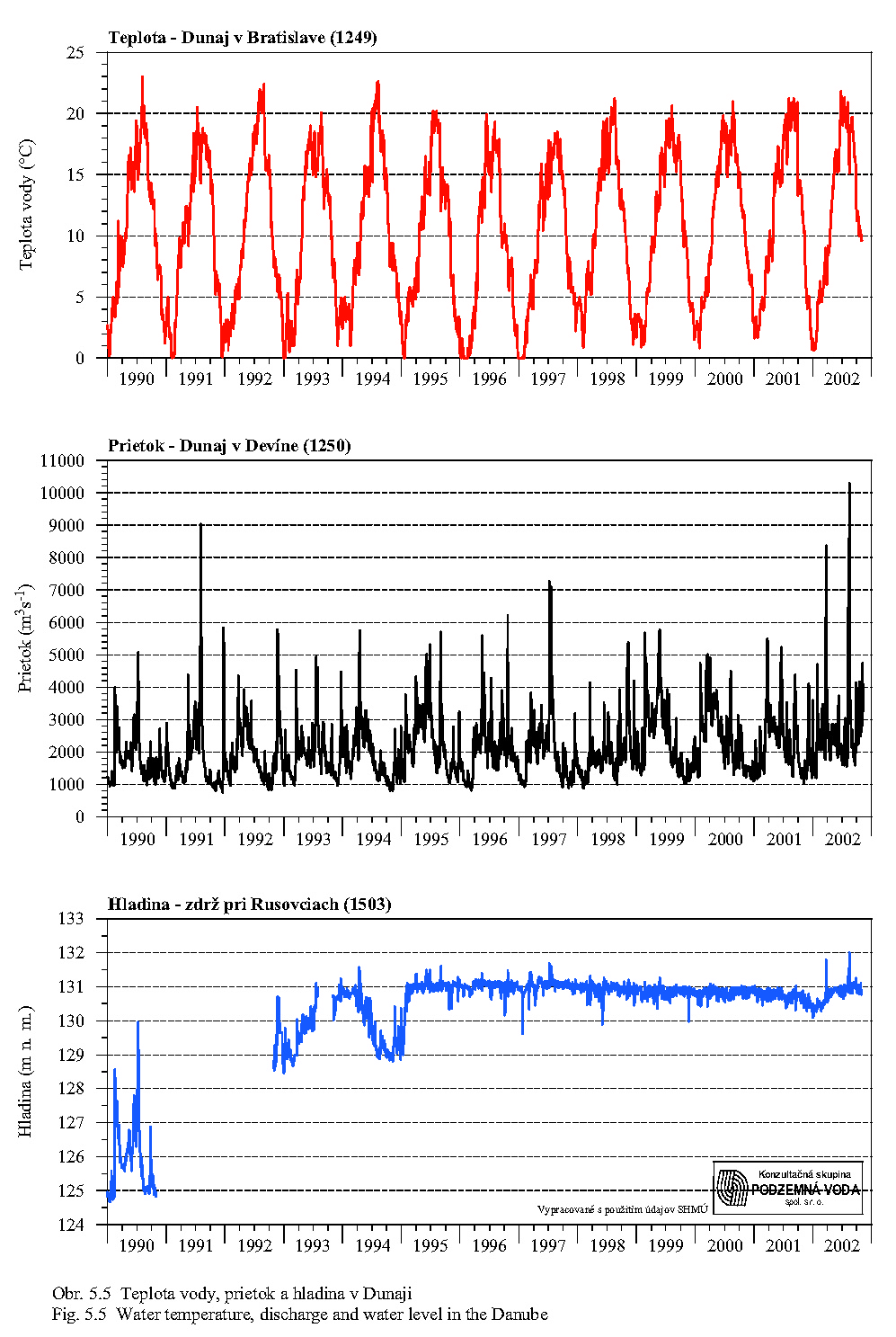
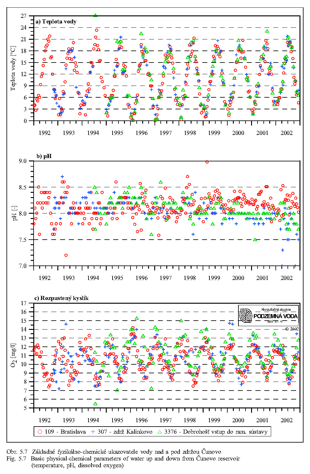
Fig. 5.5 shows the important hydrological characteristics; dynamics of water temperatures and discharges in the Danube; and fluctuation of the water table in the Čunovo Reservoir. Fig. 5.5a shows that course of temperatures has a regular sinusoid character (see also Fig. 5.9) with maximal temperature in summer and minimal in winter. Fig. 5.5b identifies the periods with increased discharges and flood states, or periods of minimal discharges in autumn.
Nutrients in floodwater could be divided in dissolvable nutrients; nutrients in the form of suspended solid materials; nutrients bound to suspended solid materials; and nutrients bound to riverbed sand and gravel.
Floods may influence dissolvable nutrients only if its concentration is diluted (snow thaw) or, in contrast, if they are added to the water during flood (surface flush and run-off after strong rains).
Quantity of suspended solids depends on the flow velocity and on the place of their releasing, for example a flushed water reservoir (dams constructed on the Danube in Austria and Germany).
Quantity of transported gravel and sand depends on flow velocity and continuity of the river (discontinuity mainly dams, lakes, overflowing dams etc.). As to the content of nutrients, the transported gravel and sand have only a small significance. In this regard, the substances dissolved in water and substances bound to the fine suspended solids have large significance.
Comparison of profiles upstream and downstream of the Čunovo Reservoir shows that passing of the water through the reservoir does not cause significant changes in dissolvable nutrients, pH and water temperature.
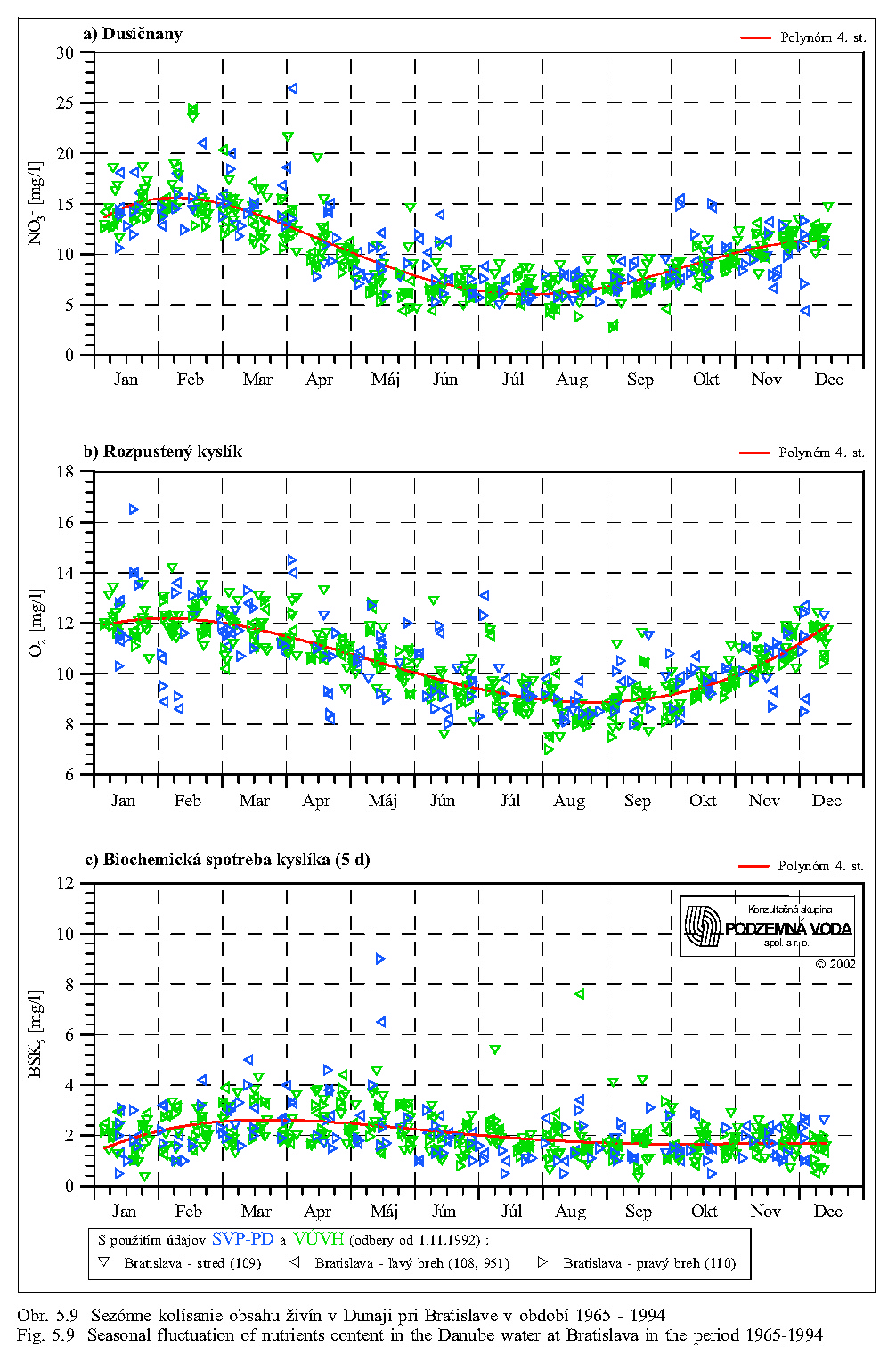
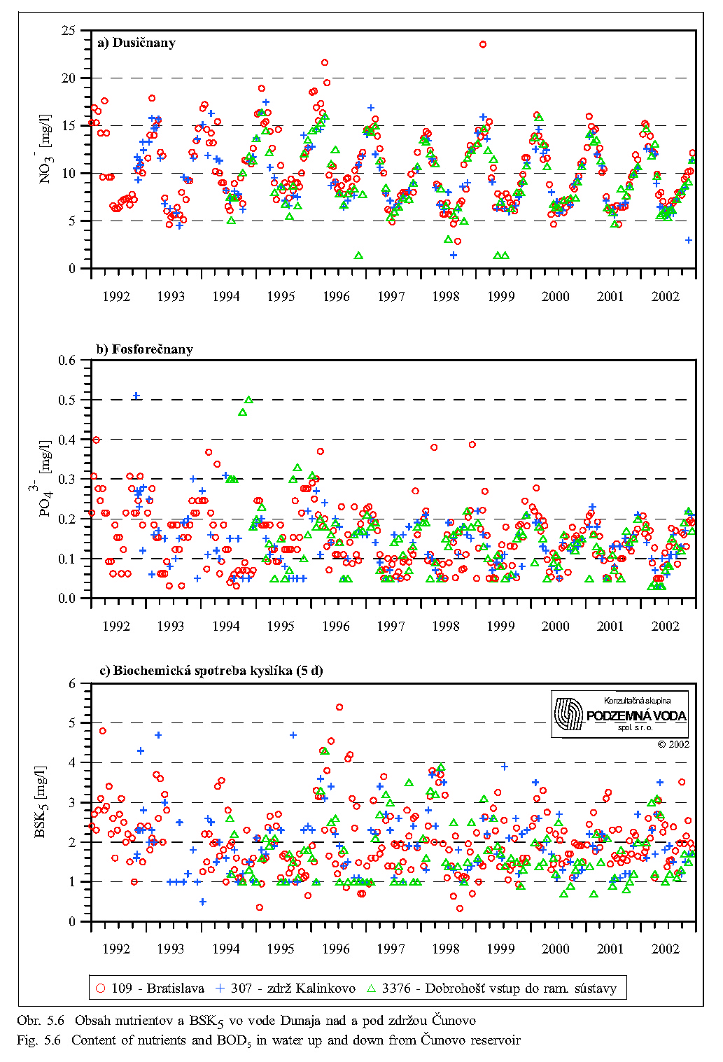
Concentration of nitrates in the flowing Danube water changes in the course of year in dependence on discharge, content of organic substances and biological activity (compare Fig. 5.6 and Fig.5.9). A higher content of nitrates occurs out of the growing season, in winter, and during the spring. The lowest content occurs usually in the late summer and early autumn.
The content of phosphates shows similar seasonal fluctuations as the nitrate content. The water in the vicinity of the intake structure of the arm system contained about 0.2 mg/l in 1995 (Fig. 5.6). It shows that the phosphate content in the Danube water is mostly sufficient and does not inhibit the biological processes.
The basic scheme of the carbon circulation in water ecosystems begins in the atmosphere, from where carbon is taken by the producers, which pass it to the consumers. The carbon passes from these two trophic levels to the destruents. The carbon present in the inorganic form as CO2 is assimilated by algae. Biochemical oxygen demand (BOD5) characterises indirectly the content of organic substances, which are subjected to aerobic biochemical decomposition. Values of BOD5 in the Danube water fluctuate in a long-term scale in a range of 1 - 3 mg O2/l and are influenced more by momentary discharges than by seasonal influences (Fig. 5.5, Fig. 5.6, Fig. 5.7, Fig. 5.8 and Fig. 5.9).
The dissolved oxygen in the danube water comes from the atmosphere and from the photosynthetic activity of water plants. Oxygen diffusion from the atmosphere into the water depends mainly on the water temperature (Fig. 5.7). The average fluctuation of oxygen concentrations ranges from 8 to 11 mg/l (Fig. 5.9).
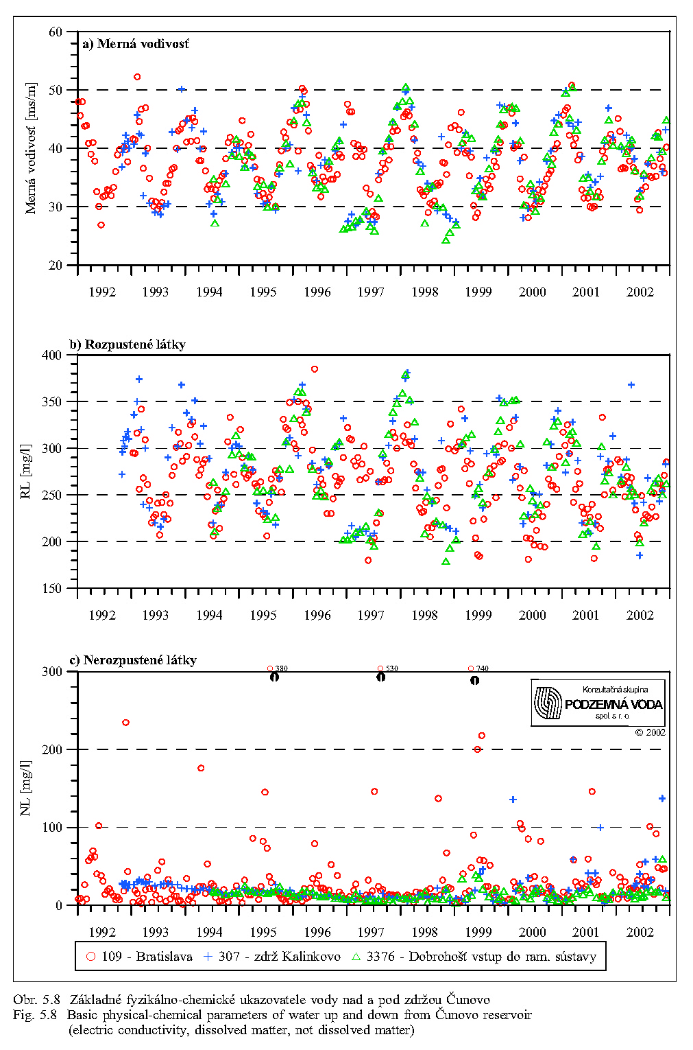
The electric conductivity of water depends on quantity of dissolved substances dissociated on ions. Together with the index of the total content of dissolved substances it represents a group index characterising the content of different substances in the water, without identification of their origin and kind. Fig. 5.8 shows, that both indices have an expressively seasonal character depending mainly on discharge in the Danube.
The water temperatures have an overall influence on the velocity of metabolic processes. The temperature optimum of most water organisms lies in the range of 10-30°C. Water temperature in the Danube fluctuates up to 20°C (Fig. 5.5). As apparent from Figs. 5.5, 5.7, 4.12, 4.13a and 4.13b, water temperature in the Danube reaches 10°C as late as in March-April. In the Danube arms, the water overheats and, in sunny weather, the temperature of the slowly flowing or stagnant water can reach considerably higher temperatures than in the main stream.
The water pH (Fig. 5.7) can essentially influence the existence of the water organisms. In flowing arms the water pH corresponds with pH in the Danube, whereas in the arms with small discharge or with stagnant water pH can considerably decline under certain temperatures.
Concentrations of other dissolvable nutrients, i.e., potassium, calcium, magnesium and sulphates, have a similar seasonal dynamics as the concentrations of nitrates and dissolved oxygen. Maximum values occur in winter and in early spring, the minimum in summer.
Content of nutrients transported in suspended form are characterised by the total content of insoluble substances (Fig. 5.8). Solid substances settled on the bottom or transported by water contain the inorganic and organic fraction representing food for different organisms. In the less populated regions the inorganic fraction predominates, while in the industrial or densely populated regions the proportion of organic substances is higher. The Danube water has a low content of organic substances (Fig. 5.6, Fig. 5.9). During flood these substances contribute to terrestrialization of the arms with small discharges or stagnant water. As apparent from Fig. 5.8, the content of insoluble suspended materials is highest at Bratislava. In the downstream direction their content gradually decreases due to sedimentation of coarse-grained suspended solid materials in the Čunovo Reservoir. In the Čunovo Reservoir, at the profile of Rusovce/Kalinkovo, the content is lower, approximately as high as in the Danube at the Dobrohošť village and at the intake structure in Dobrohošť. Comparison with the Fig. 5.5 shows that the content of suspended solids at Bratislava, and consequently also in the downstream direction, significantly depends on flow rates in the Danube. Extremely high contents of insoluble substances occur during floods.
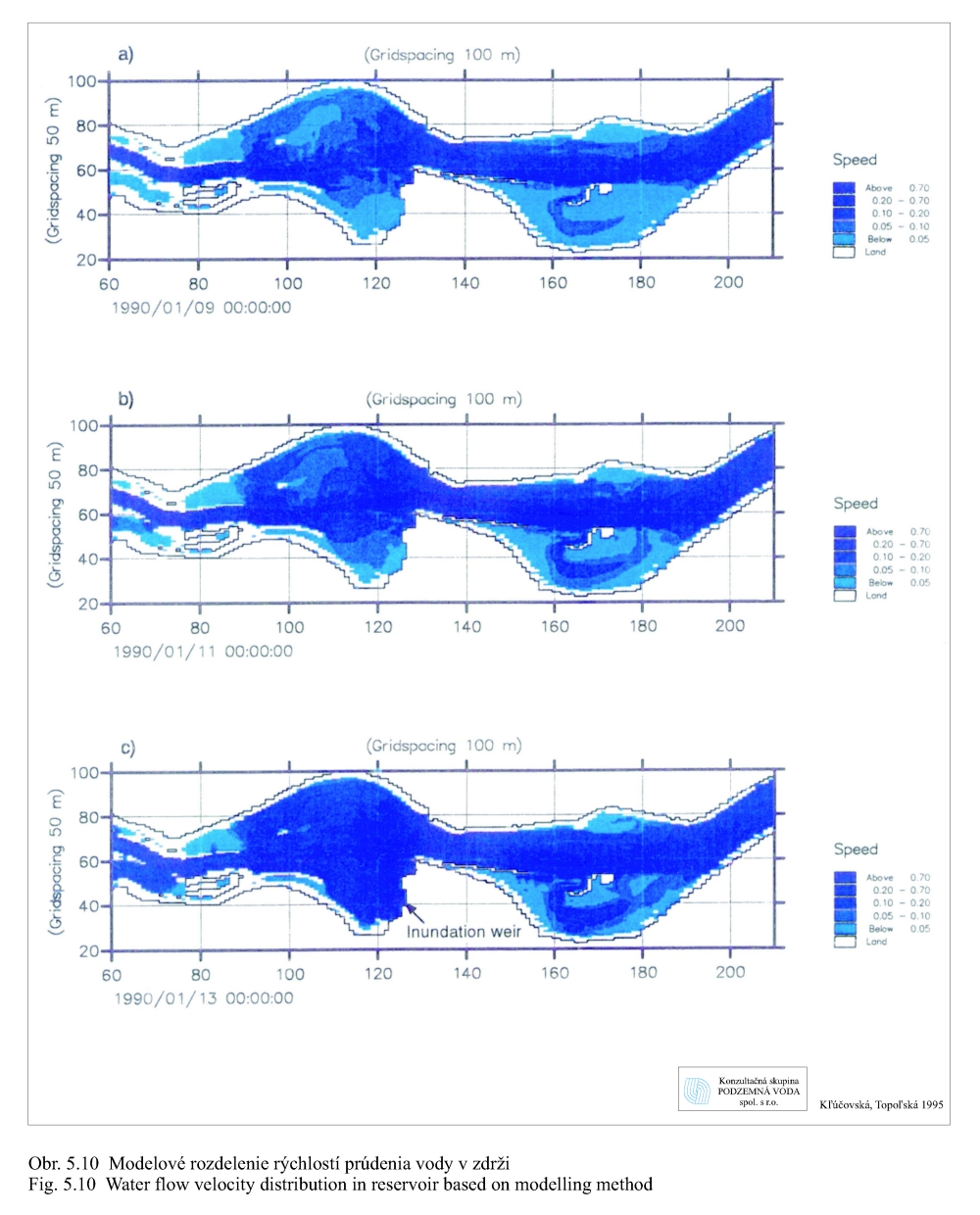
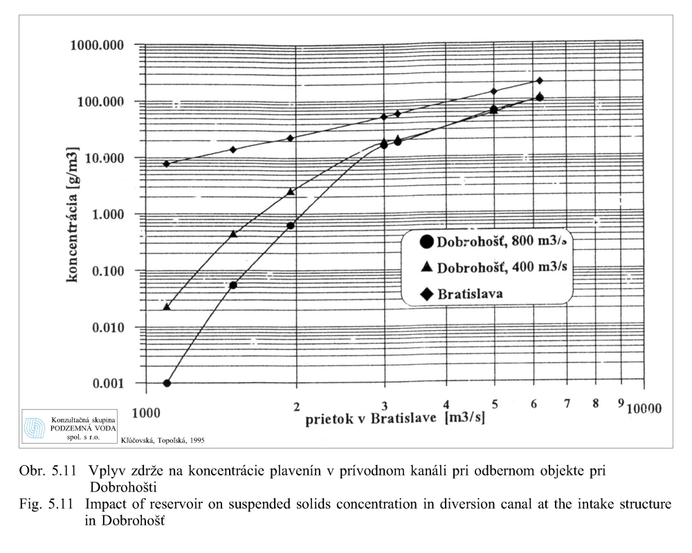
Transport of suspended solid materials depends on discharges and thus flow velocity. Fig. 5.10 shows model distribution of velocities in the Čunovo Reservoir for different discharges measured at Bratislava: a) 1950 m3/s, b) 3.200 m3/s, c) 6.200 m3/s all by discharging 400 m3/s through the Čunovo weir into the old Danube at the water level of 131.10 m above sea level (Kľúčovská, Topoľská 1995a, 1995b). The figures show conditions for transport of the suspended solid material (sedimentation, erosion/ascending) in the reservoir at different discharges. They also show the influence of the hydraulic guiding structure (shallow dam in reservoir) at Šamorín. The highest flow velocities occur in places of the Danube original riverbed in the navigation canal. Fig. 5.11 shows modelled change in concentration of suspended solid materials depending on the discharge at Bratislava (Kľúčovská, Topoľská, 1995a, 1995b). The highest concentration of suspended matters occurs at all discharges at Bratislava. At the average discharge of 2,000 m3/s, the concentration of suspended solid materials at Bratislava is 23 g/m3 water (23 mg/l) while the concentration in the intake structure into the arm system at Dobrohošť is about 0.8 g/m3. At the flood discharge of 5,000 m3/s, the concentration of suspended solids at Bratislava amounts to about 120 g/m3, while at Dobrohošť it increases to 65 g/m3. During floods the fine-grained sediments, deposited in the Čunovo Reservoir, release in the places with the higher flow velocities (Fig. 5.10).
The model solutions show that flooding of the arms during natural floods offers a larger input of nutrients in the form of suspended solids, because the water contains about 80 times more suspended materials than at average flow rates in the Danube. It would be even higher in the arms reconnected with the old Danube riverbed.
Granulometric characteristic of the suspended solids depends on flow rates in the Danube and in the by-pass canal. At larger discharges, the proportion of the coarse-grained fraction increases at the area of the intake structure at Dobrohošť. Granulometric composition of suspended materials influences sorption processes and bottom permeability after their sedimentation.
Based on the previous analysis it is possible to conclude that:
|
The Čunovo Reservoir does not cause significant changes in the level of dissolved nutrients, or in pH and temperature of water flowing via the intake structure into the river arm system. |
|
|
The concentrations of dissolved nutrients like nitrates, phosphates, oxygen, sulphates, potassium, calcium and magnesium exhibit strong seasonal fluctuations. The maximal values occur in winter and in early spring, the minimal in summer. |
|
|
The increased discharges in the Danube cause an increased transport of the suspended materials from the areas upstream of the Čunovo Reservoir, reduced sedimentation in the reservoir including coarse-gained particles, and partly also erosion of the fine-grained suspended materials from the reservoir bottom. It caused a considerable increase in content of nutrients bound to suspended materials in comparison with states of average discharge. Input of nutrients in the form of suspended materials into the arms through the intake structure at Dobrohošť is 80 times higher during the flood than at average discharges in the Danube. The suspended materials transported during floods considerably contribute to terrestrialization of the blind arms and arms with a limited discharge. |
Flora and vegetation
Systematic monitoring of flora and vegetation began by definition of the initial state on established monitoring plots (MP), founded in 1990 (Lisický et al. 1991). Among 24 monitoring plots, the following were situated in the floodplain within-dike zone: MP No. 6 (Dobrohošť), MP No. 7 (Žofín), MP No. 9 (Bodícka Brána), MP No. 10 (Kráľovská Lúka), MP No. 14 (Istragov) a MP No. 15 (Erčed), MP No. 17 (Diely), MP No. 18 (Sporná sihoť) and MP No. 23 (Čičov-Starý les). These Monitoring plots were dispersed on 3,100 ha of floodplain forests. The aim of the botanical monitoring was to obtain basic up-to-date data about the microstructure of vegetation by means of an inventory of flora and vegetation (Lisický et al. 1991). After evaluation of the state before the Danube damming in 1990-1992 the MP No. 7, 17 and 23 were excluded from the monitoring, but majority of parameters were evaluated each year (Rovný et al. 1992, Cambel et al. 1993, Matečný et al. 1994, 1995, 1996, 1997, 1998, 1999, 2000, 2001). Summarized results of the botanical monitoring, inclusive of data on foliage lost and changes in the foliage surface, were published by Uherčíková et al. (1999). In regard to different dynamics of water regime and precipitation in individual years, these results are characterised by a considerable fluctuation in the number of plant species. This fact is not, however, a negative result of the existence and operation of the Gabčíkovo project, but a regular phenomenon characteristic of the floodplains. By means of the indirect monitoring of the flora (only on the monitoring plots, not on the whole area), 760 vascular plants were recorded. However, this number includes the floristic inventory also from the monitoring plots situated outside of the within-dike zone (Podunajské Biskupice, Rusovce, Čičov etc.). Unfortunately, since the founding of the monitoring plots, the overall floristic inventory was not evaluated. The structural changes in vegetation on the monitoring plots, observed in the years 1990-1995, were generalised by Uherčíková (2001) and can be summarised as follows:
|
increased spreading of the neophytic plants with a tendency to their naturalisation, |
|
|
expressive spreading of the nitrophilous plants, |
|
|
absence of the strongly hydrophilous plants, |
|
|
impoverishment of the species inventory of most forest communities by 4 - 6 species. |
Results of almost all scientific forestry investigations from the floodplain emphasise inevitability of simulated flooding. The floods are important for a sufficient saturation of soil, even on those sites, where the ground water level is sufficiently high, also from the aspect of nutrients input (Neštický et al. 1996, Varga et al. 1997, Neštický, Varga 2001). Inevitability of the simulated floods, as a main precondition for natural regeneration of the willow-poplar forests, is also stressed by other authors (Šomšák 1998, 1999). The long-term investigation of natural reproduction of willows and poplars (Šomšák, 1998, 1999, Pišút, Uherčíková 1995) shows that reproduction of autochtonous trees (Salix alba, Populus nigra, Populus alba) from seeds happens only on denuded sediments or on the fluvizem (fluviatile soils) substrates eroded by floods. Reproductions from seed are always spontaneous and show features of fluctuations lasting several years. Reproduction under the maternal stand from seed occurred, and at present also occurs, very sporadically.
Terrestrial fauna
The present state and changes in fauna and animal taxocoenoses are evaluated on the basis of biota monitoring in 1990-1997 (Lisický et al., 1991, Rovný et al., 1992, CAMBEL et al., 1993, Matečný et al., 1994 - 2001). The initial state is described in the first three reports cited. At the beginning, the fauna was monitored similarly as the flora, on 9 monitoring plots in the floodplain within-dike zone, later on 5 plots. These plots have a very different ground and surface water regime. A wide scale of taxocoenoses of soil, epigeic and planticolous animals was monitored (Mollusca, Oniscidea, Acari, Chilopoda, Collembola, Heteroptera, Coleoptera, Neuroptera, Mecoptera, Lepidoptera, Hymenoptera, Amphibia, Aves, Mammalia, etc.). They relatively sharply reflect changes in communities of terrestrial and semiaquicolous animals
Changes in animal taxocoenoses are to be evaluated from several viewpoints. The first criterion is change in species richness. It does not represent, particularly in the floodplain forests, a significant indicative criterion, because in the process of degrading, the disappearing species, characteristic for natural conditions, are replaced by an approximately equal or even higher number of xenocoenous species. Hence, the total number of species does not decrease and may even increase. Sometimes such a state is incorrectly interpreted (also in the case of the Danube inland delta) as improvement of the ecological situation in consequence of antropogenous interventions. A correct interpretation of changes in species number needs consideration of the ecological requirements (demands for environmental conditions) of individual species. Particularly significant is the proportion of representation of species of different humidity preference. Its use, however, depends on the degree of knowledge of autecology of the individual species. From the viewpoint of bioindicative use of the animal taxocoenoses in floodplain forests, it represents one of the most significant criteria with a high indicative value. The second criterion is the proportion of species requiring permanent shadowing by woody vegetation, and species indifferent to shadowing or preferring ecosystems without shrub and tree stratum. In the floodplain forests this criterion indicates secondary, but synergically acting changes caused primarily by changes in humidity (drying of stands, decline of the number of hygrophilous trees and reduced canopy), influence of abiotic factors (trees uprooted by wind), anthropogenous interventions (silvicultural measures - thinning, selection felling).
The present structure of taxocoenoses represents a result of changes that happened before and during construction and after putting the Gabčíkovo project into operation. The draining effect of the Danube worsened ecotopic conditions for the softwood floodplain forests. It is important from the point of fauna that willows in the littoral zone and depressions and river arms earlier filled by water, which does not communicate with the water supplied arms, are drying. In the strip at the old Danube, which width varies according to the configuration of the main arms from 80 to 250 m, the ground water level does not contact the capillary fringe of the tree rhizosphere. It causes an untimely fall of foliage, and semi-natural and economic stands dry out (Pišút 1995). It causes aridisation of the territory and its colonisation by allochtonous or xenocenous faunistic elements (Jedlička et al. 1999).
Among the animal taxocoenoses, these changes are particularly strongly reflected by the taxocoenoses of edaphic and epigeic animals, which are most closely bound to the soil conditions, first of all to soil moisture. The taxocoenoses of animals inhabiting the shrub and tree strata depend more on the climatic conditions (inclusively of microclimate) and vegetation (Jedlička et al. 1999).
The floodplain represents an island partially isolated by the project from the potential immigration sources. In addition, the terrestrial zoocoenoses in the floodplain forests between Bratislava and Dobrohošť are degraded and impoverished to a considerable degree. For example, even the less hygrophilous species abundantly occurring downstream (eastwards) are missing here in the malacocoenoses, even in the most humid stands of Salici-Populetum, or they occur here in a very low abundance (Ševčíková 1997, Čejka 1999, Jedlička et all. 1999). In the majority of floodplain forests in the vicinity of Bratislava, they are replaced mainly by forest mesohygrophilous and some other hygrophilous species. In more preserved types of humid forests they are represented first of all by Clausilia pumila and Semilimax semilimax (rarely also Vitrea crystallina), in drier stand types by species of the illyric forest regiotype (mainly Aegopinella nitens, than Petasina unidentata, Monachoides incarnatus, Cochlodina laminata) and by some species of the regiotype of old forest settler species (Alinda biplicata, but also Fruticicola fruticum and on more humid sites also Arianta arbustorum). Such structure of the mollusc taxocoenosis is caused by the long-term decline of ground water level resulting from deepening of the Danube bottom. In consequence of this, the polyhygrophilous species disappeared and the possible remainder of populations were not able to regenerate. The potential immigration sources are represented by drifted material, but the potential immigrants probably do not find suitable conditions or there populations are too weak to be able of autonomous development (Čejka & Falťan 2001). A similar situation also exists in other small remnants of softwood floodplain forests downstream from Bratislava, even in the area influenced by the ground water level increase due to the Čunovo Reservoir in 1992. This area cannot serve as a potential refugee and an immigration source of hygrophilous ecoelements into the by-passed zone. The by-passed zone is isolated from the surroundings by so-called cultural steppe, hence arable land. Only downstream from the tailrace canal it contacts with an ecologically similar area of a small extent. In regard to the generally known relationship of species richness (biodiversity) and area, and the island theory, the mollusc biodiversity cannot be preserved without preservation of the mollusc taxocoenoses of the inland delta in their full extent.
In consequence of low vagility, the malacocoenoses react relatively sensitively to changes in life conditions. After the Danube damming, the largest changes in their structure and disappearance of hygrophilous species were observed in the vicinity of Dobrohošť (MP Dunajské Kriviny), Bodíky (Bodícka Brána) and Gabčíkovo (Istragov). In particular at Dobrohošť, the original malacocoenoses of the softwood floodplain forests dominated by the hygrophilous species turn into the mesohygrophilous coenoses characteristic rather for the transitional to hardwood floodplain forests. At the turn of 1980-ies and 1990-ies, there was a malacocoenosis typical for moderately humid to humid varieties of the softwood floodplain forest with dominance of the polyhygrophilous species Carychium minimum, Zonitoides nitidus and Succinea putris. Analysis of the thanatocoenoses from the soil samples revealed that the wetland species Vertigo antivertigo also lived here in the past. This specie has not been recorded in the Danubian area for two decades. After the Danube damming populations of such species gradually disappeared from the monitoring plot at Dobrohošť.
In the area of Bodíky the situation is a little more favourable. After the Danube damming, the habitats are sporadically flooded. In spite of this, we have not, however, recorded restitution of representation of the hygrophilous species (Carychium minimum, Zonitoides nitidus, Vitrea crystallina) to the original pre-dam level. Because of the dominant draining effect of the old riverbed, the short-term simulated floods influence the humidity only for a short time. Therefore we have to state that simulation of floods does not positively influence the structure of malacocoenoses. In the original hygrophilous taxocoenoses, which existed here before the Danube damming, the polyhygrophilous species were replaced by the mesohygrophilous or eurytopic species (Aegopinella nitens, Monachoides incarnatus, Alinda biplicata, Punctum pygmaeum). The taxocoenoses on the locality Istragov belonged, until 1992, to the strongly hygrophilous taxocoenoses. This monitoring plot was the only plot where the rare wetland species Euconulus alderi occurred in the pre-dam period. After the Danube damming and reduction of flow in the old Danube, the ground water level has declined, the formerly flooded shallow depressions have been reduced, and a xeroseries accompanied by the disappearance of the hygrophilous species (Carychium minimum, Oxyloma elegans, Sucinea putris, Pseudotrichia rubiginosa) begins in them.
The area of the floodplain forests in the vicinity of the tailrace canal mouthing into the Danube belongs to the last remnants of the inland delta with the occurrence of the humid variety of the softwood floodplain forest of the Salici-Populetum myosotidentosum association containing corresponding malacocoenosis. Due to the backwater effect from the tailrace canal, this area is flooded during the growing season, often twice a year. Although the herbage stratum is degraded to some degree (mainly due to presence of the neophytic species Aster lanceolata and novi-belgii agg.), the malacocoenoses show a structure typical for this type of floodplain forest. The strongly dominant species are autochtonous polyhygrophilous Zonitoides nitidus, Carychium minimum, Pseudotrichia rubiginosa, Succinea putris and Oxyloma elegans, which often reach the cumulative dominance of 90-95%.
In the downstream stretch not affected by the Gabčíkovo project (Sap - Čičov), the remnants of floodplain forests in the within-dike zone are flooded and sufficiently supplied with seeping ground water. The malacocoenoses are structurally most similar to the original communities of the most humid types of floodplain forests. It is indicated by the predominance of the polyhygrophilous molluscs well adapted to the conditions of cyclical climax. In particular the polyhygrophilous species Carychium minimum, Zonitoides nitidus, Succinea putris, Oxyloma elegans, and the forest hygricolous species Vitrea crystallina, belong to the typical dominants of the forest malacocoenoses (a typical example is the monitoring plot Čičov - Starý les).
Development of occurrence of Oniscidae is documented first of all by the strongly changing dominance proportion of the eurytopic species Trachelipus rathkei, which is tolerant to reduced soil moisture, mesohygrophilous species Hyloniscus riparius and hygrophilous species Porcellio scaber along the moisture gradient. In Dunajské Kriviny, among 7 species recorded during the monitoring (1993-1997), the eudominant species were T. rathkei and H. riparius, which was mosaic-like distributed in obviously humid places. The species composition of the taxocoenosis itself, however, did not change essentially after the Danube damming.
In bodícka Brána, 7 Oniscidae species were recorded. Their abundance fluctuated in individual years. T. rathkei was eudominant during all years, but in 1997 a sudden decrease of dominance of hygrophilous P. scaber was observed. It indicates a shift of the monitoring plot to the drier habitats. This process was doubtless accelerated by clear-cutting of the stand in the immediate vicinity of the place, where the arthropods were sampled in regular intervals.
In Kráľovská Lúka only H. riparius and eudominant T. rathkei were recorded in the first year of the monitoring. In the next years the species number increased. Dominance of the stenotopic hygrophilous species Porcellium collicola increased to 46% in 1997, but dominance of T. rathkei suddenly dropped from 98% in 1993 to 13% in 1997. These changes indicate an end of the drying of this locality.
In Istragov in 1993-1996, the taxocoenosis, poor in species number and characterised by predominance of T. rathkei, indicated a slow process of drying out. In 1997 the hygrophilous Porcellium collicola appeared and showed a high dominance. This change might indicate an increased humidity as a consequence of simulated floods.
In the Chilopoda taxocoenosis, the changes caused by the Danube damming were reflected as in qualitative as in quantitative structure. Number of occurring species changed. Except of the xenocenous species, Clinopodes flavidus, and Lithobius microps disappeared here, whereas the little hygrophilous species Lithobius lapidicola and L. calcaratus were recorded as new species. Dominance of eurytopic Lithobius forficatus increased, probably as a consequence of immigration and subsidence of conditions typical of floodplain forest. Dominance of Lithobius curtipes, a mesohygrophilous species characteristic of the Danube floodplain forests, decreased.
In Dunajské Kriviny, in the first year after diverting the Danube, the number of occurring species strongly decreased to the lowest value recorded during the whole monitoring period, and dominance of the eurytopic L. forficatus (tolerant to strong fluctuation of soil humidity) suddenly increased from 21% to 49%. A high dominance of this species was maintained also in following years. On the contrary, dominance of mesohygrophilous L. curtipes (a species characteristic of the Danube floodplain forests) decreased from 18% to 14% in 1993 and to 3-4% in the following years. Clinopodes flavidus, L. microps, L. lucifugus and L. cyrtopus (two former species are xenocoenous for this area) have not been recorded since the Danube damming. On the contrary, after the damming, Lithobius lapidicola, L. pusillus and L. calcaratus belonging to species with limited demands for soil moisture were recorded. In 1995, the number of occurring species increased to 11 and dominance of eurytopic L. forficatus decreased to 27%. The simulated summer flood may cause it. Variation of the between-year similarity of Chilopoda taxocoenosis (50-60%) in the period 1993-1997 indicates unstable life conditions in this locality.
In Bodícka Brána, shortly after the Danube damming, number of Chilopoda species decreased to 7, but in the following years it increased to the original level. Eurytopic L. forficatus was dominant during the whole period. Dominance of the characteristic species L. crassipes and L. curtipes fluctuated and L. crassipes was not recorded in some years at all. After the damming, dominance of the hypogeic species Pachymerium ferrugineum increased to 20-30%. These changes in the Chilopoda taxocoenosis indicate a shift toward habitats with a drier soil surface. This was also confirmed by measuring soil moisture.
In Kráľovská Lúka the Chilopoda taxocoenosis belonged to the richest communities in pre-dam conditions. In the period of 1991-1997, 17 species were recorded here. After the damming this number decreased to 13, among which the ripicolous and hygrophilous species Lamyctes emarginatus characteristic of this habitat type, and the hygrophilous species L. agilis and L. microps were represented. The eudominant species was L. emarginatus and dominant were L. aeruginosus and L. curtipes. After 1993 the polyhygrophilous species L. agilis and the forests species L. cyrtopus characteristic of higher altitudes were no more recorded. The former species is however xenocenous in floodplain forests and it got here probably during floods. After 1993 L. micropus was also absent in the Chilopoda taxocoenosis. The hypogeic species Geophilus flavus, P. ferrugineum and Strigamia acuminata recorded before the damming disappeared and reappeared as late as in 1997 (probably in consequence of simulated floods). Changes in the Chilopoda taxocoenoses continued also in 1997, when Lithobius pelidnus and Pachymerium tristanicum were recorded here for the first time. Changes in the species composition of this taxocoenoses indicate unstable conditions in this locality. The eurytopic species L. forficatus and mesohygrophilous L. aeruginosus, L. crassipes and L. curtipes maintained their eudominant to dominant position. Dominance of the ripicolous species L. emarginatus decreased in 1993-1995; it increased in 1996 and in 1997 this species was absent. Fluctuation of dominance of this species reflected drying off of the shore zone of the dead arm situated close to the dike. Unstable conditions were reflected, in the full extent, by the Chilopoda taxocoenosis. The lowest similarity of the samples was recorded between the years 1992 and 1993.
In the Chilopoda taxocoenosis in Istragov 15 species were recorded in 1991-1997, among which the eurytopic species L. forficatus and L. mutabilis were eudominant. The typical mesohygrophilous species L. aeruginosus, L. crassipes and L. curtipes and the hypogeic species P. ferrugineum were represented by a high percentage of individuals. In pre-dam conditions the hygrophilous L. agilis was also recorded in 1991 and 1992. Absence of this species in 1993, and increased dominance of the humidity-tolerant species L. forficatus, signaled drying of this monitoring plot. The eurytopic species L. forficatus and the mesohygrophilous species L. curtipes and L. crassipes maintained their dominance during the whole monitored period. Increase in dominance of the hypogeic species P. ferrugineum (prefers sandy, but not moist or marshy habitats) from 10% to 31% in 1996 also indicated a shift of this locality toward the drier habitats. The most significant differences in the similarity of the one-year samples (33%, 41%) exist between two pre-dam years and the year 1997. They also confirm a slow shifting of this site to the drier habitat types.
Among the bugs (Heteroptera), the most significant bio-indicators of habitat state and changes are the species living in litter and soil upper strata. They react sensitively on the changes of floodplain forest character, in particular to humidity, interventions into forests communities, their destruction, clear-cutting and subsequent aridisation and ruderalisation. In the monitoring plots studied, 85 species showed the average abundance (AA) of 6.23 ex.m-2 (Štepanovičová & Degma 1999). Epigeic heteropteran taxocoenose are characterised by a high degree of heterogeneity indicated by a low number (10) of constant or euconstant species. All other species are accsesoric or accidental elements in these taxocoenoses. The larges number of these species occurred, of course, in the driest variety of the floodplain forests, where many species immigrated for hibernation from near xerothermophilous community of the Crataegetum danubiale. As to the qualitative structure, most similar to these two communities is the bug taxocoenosis in Dunajské Kriviny (AA= 9.33 ex.m-2), where the highest numbers of species occurred, particularly after 1995, as a consequence of ruderalisation. The quantitative representation of bugs in this locality was most similar to that in Bodícka Brána (10.63 ex.m–2). At the same time these two localities showed the highest average abundance of bugs during the whole monitored period. However, only 17 species of all recorded species can be taken as characteristic for the floodplain epigeion (coenobiont and coenophilous species). For indication of changes, only those hygrophilous and mesohygropholious species (Drymus brunneus, Drymus ryeii, Scolopostethus affinis, Scolopostethus thomsoni and Legnotus limbosus) were used, whose quantitative parameters (AA, dominance, constancy) were bio-indicatively significant. Assessment of changes in taxocoenoses, caused by habitat changes occurring during the construction of the Gabčíkovo project, is based on ecological demands of the recorded species and their relationship to the habitat conditions. Bio-indicative abilities of the characteristic species were manifested particularly in the by-passed area, where their relative representation reached 74.88%. The highest values of dominance of these species were recorded in 1996 and 1997, when the condition in the floodplain forest epigeion had stabilised and the bug taxocoenoses reached a similar state as in 1991.
A strong decrease of dominance of characteristic species was recorded in Dobrohošť in 1993-1995. In that period the negative impact of clear-cutting of a part of floodplain forest and its gradual drying off was visible. In consequence of continuing aridisation and ruderalisation of the floodplain forests, the forest communities began to be penetrated by the euryecious, less hygrophilous bug species from the surrounding biotopes. Their number increased to 15 in 1995 and, at the same time dominance of the characteristic species decreased.
The strong qualitative and quantitative structural differences between the heteropteran taxocoenoses in the monitoring plots Bodícka Brána, Kráľovská Lúka and Istragov were manifested by low values of average abundance (Kráľovská Lúka for the whole period 1.97 ex.m-2, Istragov 3.09 ex.m–2), which were several times lower than in two preceding plots. The 7-year investigation has shown that litter humidity in soil depression exceeded tolerance limits, even of the hygrophilous terrestrial bugs, which occurred here for this reason in a small number of individuals.
The data on occurrence of the characteristic dominant species D. brunneus and L. limbosus, which shows a good indicative ability and sufficiently large differences in their quantitative representation, appears to be suitable for assessment of differences in humidity of litter in floodplain forests. The different ecological characteristics of both species (D. brunneus is a hygrophilous species and a typical inhabitant of litter of floodplain forests; L. limbosus is mesophilous) allows, on the base of their occurrence and population density, to characterise permanent and temporary changes in humidity conditions of their biotopes. Maximum abundance of D. brunneus in Dobrohošť was 10.50 ex.m-2 in 1992 and in Bodícka Brána 7.54 ex.m-2 in 1991; i.e., in the pre-dam conditions. The sudden decrease of its abundance in 1993 and several subsequent years was followed by an increase caused by the simulated floods in the later years. L. limbosus occurred regularly only in the driest variety of the floodplain forest, in the area outside of the inundation area (Kopáč, Ostrovné Lúčky) and it reached maximum values of its abundance in these localities in 1995. In other monitoring plots, L. limbosus occurred sporadically, irregularly, and its low to substandard abundance or even absence are unable to indicate humidity conditions in floodplain forests, particularly decrease of humidity and a visible drying.
Thee differences in values of average abundance of D. brunneus and L. limbosus are obvious, even after their pooling, according to the three groups of forest communities. In the driest variety of floodplain forests the average abundance of D. brunneus was only 0.13 ex.m-2 and that of L. limbosus 2.60 ex.m-2. In localities in the by-passed area, the average abundance of D. brunneus was 2.50 ex.m-2, and that of L. limbosus only 0.31 ex.m-2. In the localities downstream of the tailrace canal mouthing into the Danube, the average abundance of D. brunneus was 1.72 ex.m-2 and that of L. limbosus 0.41 ex.m-2. The differences in population density of the above species well indicate floodplain forests and the litter microhabitat with the lowest, highest, and average degree of humidity.
In order to illustrate accurately the impact of the influence of some factors on formation of the bug (Heteroptera) taxocoenosis in the epigeion of floodplain forests, the canonical correspondence analysis was used. It showed (Štepanovičová & Degma 1999) that among 9 tested factors only 4 gradient variables have a significance for forming the taxocoenoses of the epigeic bugs, viz., soil and litter humidity, soil pH, content of CaCo3 and average air temperature. The main factor, influencing occurrence of bugs in the floodplain forest epigeion, is a suitable degree of humidity. The closest affinity to this factor exists in the characteristic species D. brunneus, S. affinis, S. thomsoni and three further hygrophilous species, viz. S. pilosus, Holcocranum saturejae and Eurygaster testudinarius.
It has been shown that a sufficient degree of litter humidity, which is the determining factor for existence of the characteristic bug species, also persisted in the last years of monitoring of bugs (1996 and 1997). The 7-year monitoring has also shown that in contrast to the positively acting sufficient litter humidity influenced by the ground water level, the stagnant water, which has the highest level during the floods, causes shorter or larger lasting decrease not only in the qualitative, but also in the quantitative representation of bugs. This is reflected by lower abundance of characteristic species and decrease of species diversity of taxocoenoses of epigeic bugs.
For definition of optimal conditions for existence of populations of autochtonous epigeic bugs in litter and soil surface strata in the Danube floodplain forests, the above data on the qualitative and quantitative structure of their taxocoenoses can be used. They unambiguously show that the deciding factor is soil humidity influenced by ground water level. One evidence of persistence of an optimal state for bugs in the flood plain forests is above all a high density of populations of the characteristic hygrophilous species, whose dominance reached 68% in the entire are in question and in the by-passed area, where the humidity is more favourable, even 74,88%.
Number of species in the natural or quasi-natural taxocoenoses of ground beetles (Coleoptera, Carabidae) in Central European floodplain forests ranges mostly from 22 to 35, exceptionally reaches even 50 species. Number of species lower than 15 can be taken as an attribute of considerably degraded communities (of course if the low number of species dos not result from a sampling error).
In general, the natural Carabidae communities in the ecosystems of the most humid parts of the Danube inland delta existing in conditions of cyclical climate are characterised by cumulative abundance of 80-130 ind./trap/year (the jars with opening diameter of 75 mm served as pitfall traps). Abundance lower than these values (if not caused by a long-termed flooding) can be interpreted as a result of degradation. The lowest limit values (established in other types of ecosystems) characteristic of the extremely degraded taxocoenoses range from 5 to 15 ind./trap/year. Abundance exceeding 130 ind./trap/year has a different interpretation in the cyclic climax flood-plain forests. If they occur unrepeatable and are caused by a sudden increase of abundance of Pterostichus melanarius and/or P. niger, they can be taken as a mark of temporarily decreased humidity in a site. In contrast, a sudden increase of abundance of P. niger accompanies the initial succession stages on the long-termed flooded plots. If the increase in the cumulative abundance results from increased abundance of some of hygrophilous species like Agonum moestum, Pterostichus anthracinus, P. nigrita, Bembidion mannerheimi, B. biguttatum, it indicates that the ecosystem losses character of the cyclic climax and that the local conditions approximated floodplain forests flooded by stagnant water. In such cases, the cumulative abundance of Carabids ranges between 200-300 ind./trap/year, exceptionally even 400-500 ind./trap/year,
For the bio-indication of changes in the floodplain forests ecosystems, the most significant criterion is change in the representation of ecological groups species; in particular, the changing proportion of representation of species showing different preferences for humidity. In Carabids, the accurate values of hygropreferendum of individual species are not known. However, based on comparisons and field observations, the Central European Carabidae species can be classified into eight groups. Their representation allows quantifying the running changes and can serve for the direct ordination of communities. The second significant criterion is the proportion of species requiring permanent shadowing by tree vegetation, species indifferent to shadowing, and species requiring the non-forest ecosystems. An idealised natural Carabidae taxocoenosis of floodplain forests in conditions of cyclic climax should be characterised by a high proportion of polyhygrophilous species and by absence or low representation of the hygrophilous species like P. anthracinus, P. nigrita, B. mannerheimi and B. biguttatum.
In Dunajské Kriviny, occurrence of the hygrophilous Carabids strongly dropped in 1993 after the Danube damming. Some species disappeared after 1993, but representation of some more tolerant species, in particular Carabus granulatus (1993: 21,59%) and Pterostichus niger (1993: 25,52%) increased. Their increased occurrence lasted until 1995, when their abundance decreased again and, in 1997, these species were not recorded. In 1994, invasion of the xenocoenose species Pseudophonus rufipes started and culminated in 1995 (17,12% of individuals). This invasion was accompanied with occasional occurrence of several xerophilous species, particularly Licinus depressus and representatives of the Amara genus. During the whole monitoring, only the tolerant and little hygrophilous species, Stomis pumicatus showed a relatively stable occurrence (dominance of about 10%). The course of changes on Carabidae taxocoenosis from the starting point in 1989 to the state of 1997 is characterised by a continuous decrease in values of similarity of the one-year samples from 1990-1997 with the sample from 1989 (from 43-62% to 16-30%). In the whole by-passed stretch, this taxocoenosis was most affected by the post-dam changes.
In 1993 in Bodícka Brána, the abundance and dominance of the more tolerant species, C. granulatus (11,11%), Pterostichus melanarius (25,90%), P. niger (24,26%) a Stomis pumicatus (3,89%), suddenly increased. At the same time, representation of all more hygrophilous species decreased. Abundance of all species decreased in 1994-1996. This was reflected by a decrease of the cumulative abundance of Carabids to 1/3-1/2 of values observed in 1993. The most affected were the most hygrophilous species, especially Platinus assimilis, Clivina fossor, B. dentelum and B. sodalis. Only populations of some less hygrophilous or more tolerant species like P. strenuus, A. flavipes and O. obscurus remained unaffected. Their abundance, in contrast, moderately increased in individual years. In this species, however, a significant role was also plaid by their small body size. Changes of abundance of some species, that is to say, reflect not only the changes of hydrological regimen, but also changes in food supply. The worst state of the community was observed in 1995. Since 1993, invasion of the euryecious and xenocoenous species Trechus quadristriatus started, which can be taken as a significant degradative change. Proportion of representation of individual species in 1997 indicates that a moderate improvement of humidity conditions in this locality happened. This trend is, however, very moderate.
In Kráľovslá Lúka, representation of more tolerant or less hygrophilous species, C. granulatus (35,6 a 22,5%), P. melanarius (6,5 and 14,2%), P. niger (13,5 and 22,3%), increased in 1992 and this trend continued in 1993. The less hygrophilous Epaphius secalis, as a new species for this locality, was found in a considerable number. After a decrease in 1991, again increased the abundance of two less tolerant hygrophilous species, Platynus assimile and Patrobus atrorufus, whose dominance, however, decreased. After restarting of monitoring broken off in 1994 and 1995, a considerable decrease of the number of individuals occurred (from 1648 in 1993 to 636 in 1996, and to 396 in 1997). In 1996 and 1997 in the taxocoenosis only three tolerant species dominated P. strenuus (30,1%, resp. 36,36%), C. granulatus (16,82%, resp. 19,19%), and O. obscurus (3.4% resp. 10,1%). Although representation of several hygrophilous species was low, or such species disappeared, the increased abundance and dominance of these three species contributed to an increase of similarity for the whole-year samples of 1996 and 1997 with the pre-dam sample for 1987. In 1996, an invasion of the xenocoenous T. quadristriatus was recorded, but this species retreated partly in 1997. Values of species similarity index of individual one-year samples with the sample from 1987 showed a stable trend. In contrast, values of the proportional similarity index and abundance similarity index strongly dropped in 1989, 1992, and 1993, as a consequence of the described changes. Within this locality, depending on local differences in humidity and small altitudinal differences (in the range of 50-60 cm) the spatial distribution of species strongly varied (Šustek 1995). After drying of the locality and retreat of polyhygrophilous species, the more tolerant species took their place in depressions, whereas the elevated places were considerably less populated.
In Istragov (the downstream-most situated monitoring plot in the by-passed zone) two small hygrophilous species, Asaphidion flavipes (47,7%) and Bembidion femoratum (15,36%), strongly predominated in 1989. Other hygrophilous species, P. assimile (15,5%), P. strenuus (5,7%), C. granulatus (3,6%), P. atrorufus (2,4%), showed a considerable dominance. From the ecological aspect, presence of polyhygrophilous species, Europhilus fuliginosus and E. micans, was important. A high dominance of moderately hygrophilous species before substantial changes of the hydrological regimen reflected the presence of sandy soil on the major part of this monitoring plot. In 1990-1992, the cumulative abundance of Carabids decreased to one half. This decrease was caused mainly by the sudden drop of abundance of A. flavipes and B. femoratum, but abundance of most other species also decreased to 2/3 - 1/2 of the previous state. Already in 1991, the abundance of P. niger suddenly increased. Similarly, a sudden increase of abundance of P. niger was observed on other monitoring plots two years later. During 1990-1992, a temporarily stabilised state arose, but it lasted only till 1993, when abundance of several moderately hygrophilous species strongly increased (C. granulatus from 58 individuals in 1992 to 320 individuals in 1993, P. atrorufus from 11 to 211 individuals, and P. strenuus from 24 to 222 individuals). In consequence, the cumulative abundance of Carabids increased more then twice, but in 1995 it dropped approximately to the level of 1992. Simultaneously the abundance of Asaphidion flavipes again strongly increased, while representation of most other species decreased, except for the moderately hygrophilous and tolerant E. secalis. In 1996-1997, the mutual proportion of all species returned to the pre-dam state recorded in 1990-1991, but the cumulative abundance of Carabids was lower and continued to decrease. The flood of 1997 (caused by backwaters in the old river bad) again made the possible occurrence of some polyhygrophilous paludicolous species, like Agonum moestum, Badister sodalis and E micans).
Ornithocoenoses were originally characterised by a high diversity and density of species. The breeding ortnithocoenosis of the Danube floodplain forests in the pre-dam period consisted of 104 species, among which several significant breeders were represented (Milvus migrans, Aythya nyroca, Ixobrychus minutus, Ciconia nigra, Pernis apivorus, Alcedo atthis, Dendrocopos medius). Changes caused in the ortnithocoenosis of the Danube floodplain forests and in the whole Danube inland delta by the Gabčíkovo project were connected with extinction of a part of the arm system and, consequently by rise of a new biotope represented by the Čunovo Reservoir, as well as by adaptation of the persisting ecosystems on the new hydrological regime in the stretch between Dobrohošť and Sap. Processes, which are running in the ortnithocoenosis of the Danube floodplain forests, are essentially influenced by silviculture and technology of felling.
Creation of the Čunovo Reservoir caused destruction and flooding of a complex of Danube floodplain forests, islands and arms at Bratislava, Podunajské Biskupice, Hamuliakovo, Šamorín and Čilistov. The breeding ortnithocoenosis of that area before its deforestation consisted of 77 bird species. Among the more significant species, the black kite (Milvus migrans), hobby (Falco subbuteo), middle-spotted woodpecker (Dendrocopos medius), and barred warbler (Sylvia nisoria) are to be mentioned. Construction of the Gabčíkovo power station and tailrace canal caused extinction of the Danube dead arms, whose significance, from the zoological aspect, exceeded the regional scale. The breeding ortnithocoenosis before extinction of these localities consisted of 20 bird species. Some of them represented in Slovak conditions, from the viewpoint of genofond protection, species of all-Slovakian importance, e.g., little crake (Porzana parva) and ferruginous duck (Aythya nyroca).
After the Danube damming in October 1992, filling of the Čunovo Reservoir situated on the place of the former floodplain forests a new biotope arose – a water table of the surface of 38 km2. Already during the first years of existence of this new biotope, the reservoir appeared as a locality significant for migration and wintering of waterfowls. The migrating birds are attracted to a longer rest and greater concentration on the extensive water table. During the migration, flocks of cormorants, geese, ducks, divers, grebes, gulls and waders concentrate on the reservoir. Because the water table usually does not freeze during winter, many species of waterfowl hibernate there. For breeding of birds, an artificial island (of 5.5 ha) was built up in the centre of the reservoir, which is inhabited by colonies of black-headed gull (Larus ridibundus) and common tern (Sterna hirundo). Other expansive species include the tufted duck (Aythya fuligula), red-crested pochard (Netta rufina), yellow-legged gull (Larus cachinnans), and mediterranean gull (Larus melanocephalus). A similar process also runs in other localities in Slovakia (for example, the Sĺňava Reservoir near Piešťany).
After putting the Gabčíkovo project into operation, a redistribution of wetland biotopes important for birds started. Some localities (for example Istragov Island near Gabčíkovo) dried out, but in place of the cut-of dead arms, new wetlands arose (for example the Forrás marsh near Bodíky).
After putting the Gabčíkovo project in operation, two bird species ceased occurring as breeders in the arms system – sand martin (Riparia riparia) and common sandpipper (Actitis hypoleucos). Sand martin nested there in the banks of river arms. After putting the project into operation, the lateral erosion, even in its moderate forms, was stopped. The banks have been grown and became unsuitable for nesting of sand martin. Similarly the nesting biotopes of common sandpipper, which nested on the gravel-sandy banks, have grown and also became unsuitable for its nesting.
The Istragov locality fulfilled an important role as a hunting territory for herons (first of all for great white heron (Egretta alba), grey heron (Ardea cinerea), and black stork (Ciconia nigra)) at the time during chicks fledging and before migration. At low water level the birds used the extensive terrain depression with stagnant shallow water for easy hunting of food. This phenomenon also occurred in other parts of the arms system, but in Istragov it occurred most frequently. In august and september, often 200 herons and some tens (70-80) of black stork hunted there at the same time. After the change of water regimen this phenomenon disappeared in this stretch of the Danube. The forrás marsh serves, at present, for birds nesting in littoral vegetation, especially reeds (Bohuš 1999).
In spite of the changes that have been observed in the ortnithocoenosis, the whole area of the Danube arm system with floodplain forest and a mosaic of marshy biotopes, represents, from the ornithological viewpoint, even at present, an area exceeding the regional significance. It is desirable to begin its re-naturalization.
The species composition of the mammal fauna (Mammalia) did not change essentially after construction of the Gabčíkovo project, but changes in its structure appeared. Taxocoenosis of small terrestrial mammals consists of Sorex araneus, Apodemus flavicollis, Clethrionomys glareolus, Sorex minutus, Crocidura leucodon, Crocidura suaveolens, Microtus arvalis, Microtus oeconomus, Pitymys subterraneus, Apodemus sylvaticus, and Micromys minutus. The anthropogenous factors support spreading of Microtus arvalis and M. musculus, which are unoriginal there.
The basis of small mammal taxocoenosis consists of four species, Apodemus flavicollis, Sorex araneus, Clethrionomys glareolus, and Apodemus sylvaticus, among which the tree first universally forest species strongly predominate. The flood or their absence has a determining influence on the dominance structure of this synusy dominance structure changes particularly along the humidity gradients. The most flood-resistant species is A. flavicollis, but populations of S. araneus and C. glareolus also quickly regenerate after floods. In the absence of floods, C. glareolus becomes the absolutely dominant species whereas dominance of S. araneus and to certain degree also of A. flavicollis declines. Decreased ground water level results in reduced trophicity of biotopes and, as a consequence, in reduced cumulative abundance and biomass of small mammals.
It is obvious that mammalian taxocoenoses in the within-dike zone survive the long-termed stress manifested by a long-termed autodominance of the single species C. glareolus. Ten years after the Danube damming, the population of C. glareolus considerably increased to the detriment of A. flavicollis, which together with S. araneus and C. glareolus represented 80-90% of biomass of micromamalia. In the pre-dam conditions, the floods reduced the population of C. glareolus, because its ability to save from floods by ascending wooden plants is much smaller than in A. flavicollis, which predominated there in the past. This state is also undesirable for the reason that C. glareolus is a serious competitor for the space and food resources for the relict and endangered species Microtus oeconomus, whose population size decreased so critically after putting the Gabčíkovo project in operation that its survival in Slovakia is put into question. A. flavocollis was not such a serious competitor for M. oeconomus, because it eats mainly various seeds. From this reason, in the past M. oeconomus occurred, although not abundantly, in all suitable habitats in the entire within-dike zone and its population very quickly regenerated after the floods.
In the situation, where floods elevating the water level by 30-40 cm for a short time are simulated in an improper time (and do not fulfil other functions, especially input of nutrients), they can damage the most valuable and sensible elements of the small mammal fauna for which it would be more desirable to maintain a stable water table during the whole year. Flooding does not have a negative impact on small mammals in autumn (but at that time the floods are untypical) when they cannot damage the nests of the relict and critically endangered M. oeconomus with litter. Its abundance strongly decreases in the localities in the within-dike zone and, at present, M. oeconomus no longer occurs in most localities. The primary cause of this was the drying of the whole arms system in winter 1992-1993, when even the last bodies of stagnant water froze to bottom. Similarly, the porous sandy soil with the not deeply constructed nests of M. oeconomus also froze. In these places, M. oeconomus never could construct deep holes because of a high level of ground water, which however helped to maintain the soil temperature above the ice point. Due to frost and low ground water level, the nests of small mammals, particularly of M. oeconomus, on the margins of surface waters and their inhabitants froze. The competitors, Apodemus flavicollis, but mainly Clethrionomys glareolus were not affected in this way, because the major part of their populations had nests in drier and higher situated places and successfully hibernated. In the next growing season, C. glareolus, having successfully hibernated and having born a new generation began to spread into the places originally inhabited by M. oeconomus, where it forced out the last hibernated individuals. Later, no more floods came, which helped to reduce the population of C. glareolus. The third factor contributing to reduction of the already decimated populations of M. oeconomus was simulating of floods in the spring. Increase of the water table in the arms affected only the species reproducing in vicinity of the water bodies, especially M. oeconomus.
Another change in the present-day within-dike zone is absence of S. araneus, the third most abundant species of floodplain forests.
The arm system represents in its present state an ideal habitat for beavers. The Čunovo Reservoir is, however an invincible barrier for beavers. Therefore the beavers cannot colonise the ideal biotopes in the arm system, though the population in Borská nížina lowland increases every year. In 2002, only 3-4 territories inhabited by beaver were recorded in the arm system, a reproducing pair inhabited one of them. We presuppose that these beavers immigrated there through Little Carpathians and then downwards along brooks and further via Dudváh, Čierna Voda and Vážsky Dunaj rivers, and finally, in the upstream direction, penetrated the arm system (two another beaver territories were also recorded at the Malý Danube).
It can be concluded that the most serious changes in the terrestrial fauna were recorded in the monitoring plot Dunajské Kriviny near Dobrohošť, situated close to the beginning of the by-pass canal. Draining effect, loss of the original hydrological regime and absence of floods caused profound changes in its ecosystem. The water level in the upstream-most part of the water supply canal, supplying floodplain, is too low and insufficient for the correct function of the watering and flooding of this monitoring plot. The last flood in pre-dam conditions, which influenced a major part of this monitoring plot, was in 1991. The first flood after damming the Danube was in 2002. The underwater weir in the old Danube riverbed at Dunakiliti, which could improve this situation, was finally constructed 2 km upstream, at Dunakiliti. Originally, a typical Ulmeto-Fraxinetum Populetum association covered this monitoring plot. The upper layers of soil profile consisted of thick layers of deposited sands. Soil moisture ranged from 15%-25%. After 1992, the draining effect of the old Danube caused a loss of surface waters, a decrease of ground water level, and a decrease in soil moisture to 0-20%. Since 1992, the ground water level has stabilized, with minimal fluctuations at a depth of 4,2 m (2.5-3.3 m in 1992). Conditions for a hardwood forests arose. In general, the proportion of hygrophilous and typical species decreased. On the contrary, the xenocoenous invaded this locality. A moderate increase in soil moisture after simulated flooding positively influenced the communities of edaphic animals (Acari, Oniscidea, Chilopoda) and, to limited degree, of taxocoenoses of epigeic organisms (Coleoptera, Heteroptera). The small terrestrial mammals also indicated an improvement of soil moisture. The existing data do not allow saying whether the moderated aridisation observed in the last years of the monitoring represents a permanent trend or a climatically caused fluctuation swing. At present the terrestrial communities in this monitoring plot belong to the most degraded in the whole area monitored. The adaptive process towards a hard-wood floodplain forest move forward only slowly.
The monitoring plot Bodícka Brána situated in the downstream part of the by-passed area represents an elm-ash stand with admixed poplars and willows, with a higher soil moisture (25-35%) and ground water level at the depth of 2 –2.5 m. Clear-cutting of a part of the poplar cultivars stand caused an undesirable opening of this stand. This resulted in changes in composition of the herbage and shrub layer and, subsequently, in communities of terrestrial animals (penetration of the open-landscape species, decrease of occurrence of hygrophilous species and increase of mesohygrophilous and euryecious species). Many of the hygrophilous species (Coleoptera. Mollusca) occur close to the threshold of their observation possibility. Decrease of occurrence of a part of species stopped or even reverted in the last year of the monitoring and abundance of some hygrophilous species (Coleoptera, Lepidoptera, Oniscidea, Chilopoda) increased again. The euryvalent and moderately hygrophilous species of butterflies (Lepidoptera) maintain their high dominance. In spite of the observed changes, the state of the communities can be still taken as reversible (re-increase of abundance of some hygrophilous species). It seems that during the last two years of the monitoring the structure of the communities returned into the state, that arose immediately after diversion of the Danube. Durability of this trend is, however, hardly predictable and it depends on interaction of soil moisture, timber exploitation and fluctuation of climatic factors.
The monitoring plot Bodíly – Kráľovská Lúka has, in the by-passed zone, the largest distance from the flowing arms. It was regularly flooded each year (sometimes even twice a year) and until 1992 it fully depended an the floodwater. Until 1997, decrease of the ground water level and drying of the marshy shore zone were observed in dry years. The plesiopotamal in the core of this plot separates the obviously drier habitat situated closer to the dike and grown by a poplar monoculture from a humid softwood floodplain forest (Salici-Populetum). Changes in species composition signalise instability of conditions. However, the general trend of decreasing species diversity (Oniscidea, Coleoptera) and the increase of dominance of mesohygrophilous, tolerant and xenocoenous species (Mollusca, Coleoptera) continues in spite of the fact that this trend slackened or even stopped in some taxocoenoses (Chilopoda, Lepidoptera). It signals slackening or even stopping of the negative succession trends in general. It is, however, obvious that this slowing down is a consequence of two more humid growing seasons in the last years. In addition, a long-term flood occurred in the growing season of 1997. In general, the succession of taxocoenoses runs in the direction toward the communities being characteristic of drier types of softwood floodplain forests. Within the framework of locality, the spatial distribution of species strongly changed depending on moderate variations of surface altitude (about 50-60 cm). After the drying and retreat of the polyhygrophilous species, the more tolerant species replaced them in the depressions, while the more elevated places became less inhabited. The changes in the ortnithocoenosis do not result only from operation of the Gabčíkovo project, but they were also caused by another significant factor – the system of silviculture.
The locality Istragov, situated in the downstream-most part of the by-passed area, belonged until 1992 to strongly hygric biotopes of the softwood floodplain forests (Salici-Populetum myosotidetosum Jurko, 1958) with more patches grown by alders. Close to the old Danube, the poplar monocultures were situated. These were gradually clear-cut during the time of monitoring. A layer of alluvial sand covered the locality. After the Danube damming and decrease of discharge in the old riverbed, the ground water level sunk, the soil moisture in the surface layer decreased by about 15%, extent of shallow flooded depressions was reduced, and a xeroseries began to develop (Lisický 1995, Ševčíková 1997). Even in the lowest places, the secondary succession runs to the drier variety of the flood-plain forests community (Salici-Populetum typicum). The large scale cutting of poplars and opening of the stands contributed to drying of the locality. Retreat of the species indicating marshy habitats or polyhygrophilous species (Mollusca, Coleoptera) was recorded in the taxocoenoses of terrestrial animals. They were replaced by moderately hygrophilous forest species. It indicates the drying trend on the locality. These changes were connected with massive felling to clear-cutting of the stand and subsequent changes in other layers of ecosystems. The trend of a strong retreat of polyhygrophilous species and aridisation, however, slowed down in some animal groups (Mollusca, Lepidoptera) in 1996, and the adaptive succession changes (Mollusca, Chilopoda) are slower in comparison with the vegetation. From the representation of individual ecological groups of species the ecosystem in Istragov seems to be less affected among the other monitored localities.
Aquatic fauna, eupotamon (taxocoenoses of the Danube old riverbed)
In the potamoplankton of the old Danube, the average proportion of euplanktonic Crustaceans decreased to a certain degree. This is a result of reduced reproduction of planktonic Crustaceans in the arm system and, thus the reduced drifting into the old riverbed. In the first two post-dam years the euplanktonic species more (Cladocera) or less (Copepoda) retreated in the old Danube in the annual averages, whereas the quantitative proportion of tychoplanktonic (benthic and littoral) species remained unchanged or increased (Illyová, 1996, Vranovský, Illyová 1999). Among the Cladocera, these were the species Alona quadrangularis, A. affinis, A. rectangula, Macrothrix hirsuticornis and Chydorus sphaericus; and among the Copepoda Nitocra hibernica and Eucyclops serrulatus. Quantitative proportion of pseudoplankton was (similarly as before the Danube damming) larger in the profile at Dunajské Kriviny than in the profile at Gabčíkovo. It is, however, to be noted that in individual samples the quantitative proportion of both compared ecological groups fluctuated and the proportion of the true plankton in the old riverbed depended on their drifting from the arms of the parapotamal or plesiopotamal type situated upstream of the monitored profile (Vranovský, Illyová 1999).
Influence of the Danube damming was reflected by an intense change in the taxocoenoses of the micro- and macrozoobenthos (Matis, Tirjaková 1995 a, b). First of all, the proportion of the terrestrial species (of the genus Colpoda) increased. They get into the river by drifting after terrain preparation of the Čunovo Reservoir. The strongly reduced discharge and the lowered water table in the old Danube, and filling of the Čunovo Reservoir with water resulted in forming of taxocoenoses characteristic for waters in which decaying processes, bound with a sudden development of bacteria, are running. It was reflected by increased abundance and diversity of Infusoria and Flagellata. In consequence of these changes, the character of biotopes changed. The flow velocity decreased and some river stretches were isolated and changed into stagnant water bodies in which typical taxocoenoses began to be formed. In the through flowing arms the species diversity and abundance enriches particularly by Flagellata and Infusoria. The stretch upstream of the damming (locality Kopáč) does not change apparently, and the number of species and low abundance characterize the original river conditions. In this first period after creation of the reservoir, some rare species appeared, among which some species (Stentor multiformis, Balantidioides bivacuolata) were recorded in Slovakia for the first time. In the old Danube species diversity and abundance of some monitored groups increased, particularly of Mastigophora. It was caused by decrease of the flow velocity and increased sedimentation. The increase in the number of terrestrial species (Colpoda cucullus, C. inflata, Leptopharynx costatus, Colpoda steinii) is also striking. It indicates that the river brings a lot of sediments, and its bottom is silted. After the Danube damming, stabilisation of taxocoenoses showing high diversity and abundance started. These taxocoenoses become more similar to those of permanently discharging arms. The species diversity and abundance decrease in the direction from Dobrohošť to Istragov (Krno et al. 1999) due to changes in the bottom substrate. In the locality Kľúčovec, in pre-dam conditions, the abundance of Infusoria remained on a low level all year. The influence of damming was recorded after the year 1993 when a striking increase of abundance was recorded. A high abundance was also observed in the following years due to more stable riverbed.
Among the macrozoobenthos, the representatives of permanent fauna and Chironomidae predominate at the expense of other temporal fauna. Change in hydrological regime caused differentiation of the original bottom into two stretches. In the upstream stretch, to which the profile at Dunajské Kriviny belongs, the decrease of flow velocity caused stabilisation of the originally moveable bottom. The changed abiotic factors allowed the algae to form the rich growths on the stable gravely bottom. In the downstream stretch, at Istragov, where the backwaters reach, or at Sporná Sihoť, where the regular daily fluctuations of the water level occur, the benthic communities changed profoundly. After the changes of the bottom substrate and hydrological regime (strong decrease of discharge and flow velocity), the original benthic community was destroyed. In the first years nearly no zoobenthos occurred on the bottom. Only later a new benthic community started to be formed (Krno at al., 1999). After the decrease in the water level of the old Danube we observed a mass occurrence of dying benthic macro fauna of the bare riverbanks.
The monitoring of the permanent fauna (Košel, 1995b; Krno at al., 1999) showed that abundance of Gastropoda increased in the upstream stretch (Dunajské Kriviny – Gabčíkovo) (Košel, 1995a). The highest increase was observed in all previously dominant species Ancylus fluviatilis, Lymnaea ovata and Bithynia tentaculata. The following new species were recorded there: Nais christinae (Naididae), Limnodrilus hoffmeisteri, Potamothrix vejdovskyi (Tubificidae), Gammarus roeseli and Chaetogammarus tenellus (Amphipoda). Decrease was observed in Dendrocoelum lacteum (Hirundinea) and Dikerogammarus haemobaphes (Crustacea). After 1995, the species diversity of the permanent fauna increased. The mollusc Lithoglyphus naticoides spread in the Danube. At the same period, a striking shift in the proportion of food gilds from filtrators to scraptors (algophages) was recorded. This indicates a high increase of periphyton in the river and transition of the flow metabolism from heterotrophy to autotrophy. Abundance and biomass of the pontocaspic crustacean species also increased (Jaera istri, Corophium curvispinum and Dikerogammarus villosus). The Tibificidae family increased among Oligochaeta. The scraptors Dikerogammarus haemobaphes, Dikerogammarus villosus and Corophium curvispinum (Amphipoda), eaters of fibrous algae (Jaera istri - Isopoda) and representatives of the Naididae family living on algal growths became dominant. The fine sediment between the gravel becomes a suitable biotope for the species of the Tubificidae family (Limnodrilus spp., Potamothrix sp.) inhabiting the muddy substrates. Due to the increased food supply, abundance and biomass of the above groups increased several times.
In the Danube downstream part at Istragov the species diversity of the permanent benthic fauna decreased. Some previously dominant species disappeared and some new species of Oligochaeta, (species of the Limnodrilus genus bound to muddy substrate) began to occur and their abundance gradually increased. The stagnophilous species, Asellus aquaticus and Limnomysis benedeni (Crustacea), appeared as new species. After 1995 previously dominant Cladocerans disappeared and some new representatives of Oligochaeta appeared which did nor occur at all or occurred only in a limited extent, for example the Limnodrilus species bound to muddy substrate. Their abundance gradually increased. After the complete change of substrate character and water regime (decreased flow rate and velocity), the original benthic community was destroyed. In the first years after changes the bottom remained without zoobenthos. Only later a new benthic community began to be formed. This was characterised by an absolute predominance of Oligochaeta and species Limnodrilus claparedeanus and Limnodrilus hoffmeisteri, which are not original in this type of biotope.
In the second half of 1995 a considerable decrease of abundance of the macrozoobenthos permanent fauna was recorded in the Danube stretch Dunajské Kriviny – Gabčíkovo. These changes are connected with construction of the submersible weir in the Danube at Dunakiliti, which caused a strong water turbidity and covering of the bottom with fine sediments. In 1996, fluctuation of water level in the riverbed caused denudation and flooding of the ripal depending on supplying the arms on the Hungarian side with water. Because the flood waves lasted shortly, the benthic fauna in the ripal zone was relatively poor.
Similarly to the regulated downstream of Rhôna (Fruget, 1991), except from Chironomidae, the species Baetis fuscatus, Caenis luctuosa (Ephemeroptera), Psychomyia pusilla, Hydropsyche modesta and Ceraclea dissimilis (Trichoptera) (Tab. 5.8) predominate in the Danube temporary fauna after 1992. Later, for instance in Rhein (Tittizer et al., 1989), more substantial changes in the macrozoobenthos did not occur in spite of improvement of water quality. Similarly, as in the Danube, it is connected with reduced geomorphologic diversity of the river and its contact with the arm system. This is also reflected in the considerably reduced heterogeneity of hydro systems (Fruget, 1992), and impairment of functional integrity in linking of the river with the river arm system. Since 1993 the taxocoenoses of Ephemenoptera have been strongly, qualitatively and quantitatively, impoverished in the old Danube, where only two eurytopic species, Baetis fuscatus and Caenis luctuosa (rarely C. macrura), continued to occur. Both these species have replaced the species Caenis pseudorivulorum in the old Danube between Dobrohošť and mouthing of the tailrace canal into the Danube at Sap village. The fauna of caddisflies consisted of representatives of two genera - Hydropsyche and Psychomyia – similarly as in regulated European big rivers Rhôna (Bournaud et al., 1990) and Rhein. Proportion of algophages (Psychomyia) increased on detriment of filtrators (Hydropsyche). At the same time, the species Hydropsyche contubernalis and H. bulgaroromanum were replaced by the species H. pellucidula and H. modesta (Krno et a., 1999). Later the species Rhyacophila dorsalis also appeared. The former species are typical of smaller water flows, as the old Danube has become. Stabilization of the bottom and a better trophicity in 1994 and in the first half of 1995 made possible a considerable increase of mayflies and particularly caddisflies.
The Danube damming caused a strong increase in the number of recorded chironomid species after 1992 (Krno et al., 1999). While in 1990-1992 we recorded 6 species, in 1993-1995 their number increased to 18, which was caused by changed hydrologic conditions. In consequence of reduced discharge and decline of flow velocity, the bottom was stabilised to certain degree. It made possible colonisation of several new species, for which the previous extremely lotic conditions were unfavourable. Abundance of originally predominating species Chironomus gr. fluviatilis moderately decreased, whereas abundance of some originally rare species increased considerably (Microtendipes gr. chloris, Chironomus gr. reductus and Chironomus sp.). The species Cryptochironomus gr. defectus and Dicrotendipes nervosus belong to species, which have preserved their original frequency and abundance. Decline of flow velocity in old Danube caused settling of a 0.5 m thick layer of clay-sandy sediments, which were not inhabited by aquatic insects, except for chironomids (Chironomus gr. fluviatilis, Chironomus gr. reductus, Cryptochironomus gr. defectus, Endochironomus sp., Polypedilum gr. nubeculosum) and the stagnicolous and psamophilous species Ephemera vulgata (Ephemeroptera).
While in the pre-dam Danube the temporary fauna formed, in annual average, about 30% of the cumulative abundance of macrozoobenthos, in the old Danube this value decreases under 10% (years 1998-2001), which is an analogy with its natural representation of the Danube arms. In autumn 2001 the simulated flood very positively influenced the caddisfly fauna. The genus Hydropsyche represented by H. incognita and several other species have reappeared (Tab. 5.1).
From the viewpoint of occurrence of fish it is important that putting of the Gabčíkovo project in operation caused a considerable reduction of flow rate in the old riverbed, slowing down of the flow velocity, shift of bank line into middle of the old riverbed, shallowing of the littoral, and, at Istragov, covering of riverbed by muddy sediments. In consequence of this the littoral zone does not more offer natural covers to the fish. These changes are reflected in a reduction of the abundance and species diversity of the ichtyocoenosis. The species number decreased from 19 species recorded in 1991-1992 to 7 species in 1993. Lack of cover and covering of the littoral by muddy sediments and the littoral monotony caused that this locality is not searched by the rheophilous species, but the eurytopic species. Among the species, which were not recorded after 1993, 9 species were rheophilous (L. lota, G. baloni, B. barbus, C. gobio, L. cephalus, L. idus, G. kessleri, G. albipinnatus L. leuciscus, L. idus and B. barbatulus), and 8 eurytopic (A. alburnus, A. bjoerkna, C. auratus, C. carpio, E. lucius, S. lucioperca and P. fluviatilis, P. marmoratus [Černý (1999)].
It is to be stressed that the critically endangered species, requiring attention, have disappeared the Gobio kessleri and the wild form of Cyprinus carpio, endangered Gymnocephalus baloni and the species L. idus and L. lota. Reduction of population size of Chondrostoma nasus and Stizostedion lucioperca is also a warning.
Parapotamon (communities of the parapotamal type river arms)
After putting the project in operation, the hydrological regime in the floodplain river arms, situated upstream of the port of Gabčíkovo (they belong to system of Vojka, Šuľany, Bodíky and Baka) is considerably different from the regime in the arms situated downstream from the Gabčíkovo port towards village Sap. While the arms upstream became supplied with water from the intake structure near Dobrohošť, the arms downstream are not artificially supplied with water. But the downstream arms are relatively intensively influenced by the backwater from the confluence of the old Danube with the Gabčíkovo tailrace canal. Since putting the water supply into operation, this difference is also reflected in the composition of the planktonic crustaceans. In the upstream arms the true plankton abundance of the planktonic crustaceans retread and the entire zooplankton decreased, while the percentage of tychoplanktonic species increased (among cladocerans mainly Alona guttata A. rectangula, Chydorus sphaericus and Disparalona rostrata, among copepods Nitocra hibernica). In 1995 low abundance of euplanctonic crustaceans and mostly also dominance of tychoplanktonic forms continued to persist (Vranovský, Illyová 1999).
In the Istragovské Rameno arm, not artificially supplied with water, a quantitatively rich crustaceoplankton with a strong representation of euplanktonic species, above all the copepods, survived. Among the euplanktonic cladocerans the dominant species were Bosmina longirostris or Diaphanosoma orghidani, among copepods mostly Cyclops vicinus, Acanthocyclops robustus or Thermocyclops oithonoides. It was caused by sporadic flow in the arm, which was mostly filled by stagnant water with the water level fluctuation dependent on of the backwater level fluctuation. Increased proportion of the tychoplanktonic forms, in comparison with the past, results, according to our opinion, from the accelerating terrestrialization, shallowing and overgrowing of the arms.
In the arms of the parapotamal-type (former dead arms) between Dobrohošť and Gabčíkovo (river km 1840-1820), the average abundance and biomass of the zooplankton, particularly of the planktonic crustaceans, considerably decreased after the Danube damming. Percentage of euplanktonic crustaceans considerably declined and the tychoplanktonic (littoral and benthic) species became dominant. These changes result from the transformation of the periodically discharged arms, which were favourable for existence of planktonic crustaceans, into the permanently discharged arms, which offer considerably worse conditions for zooplankton, particularly for the planktonic crustaceans. Such a situation also persisted in the arms of the system of Vojka and Šuľany in 1995 and in the next years. Some increase of abundance and biomass of the zooplankton, particularly the planktonic crustaceans, in the downstream part of the former system of Baka indicated light improvement of abiotic condition for the zooplankton in the downstream part of the flowing arms (Vranovský, Illyová, 1999).
The conditions in the arms of the parapotamal type in the stretch between Gabčíkovo and Sap are similar to the pre-dam state in spite of the fact that they are situated in the by-passed area. Due to it they are more favourable for development of euplanktonic crustaceans. The euplanktonic species mostly continue to predominate over the tychoplanktonic species.
In the upstream part of the Danube arm system (Bodícka Brána) supplying with water from the reservoir created rheophile conditions, which reduced species diversity of the micro- and macrozoobenthos. The communities reacted to the change of the arm character by destabilised structure (Krno at al., 1999). The communities of the macro- and microzoobenthos in the discharged arms not supplied artificially with water (Istragov) are characterised by the typical inhabitants of sapropel and muddy substrate, which predominates in this locality (Krno at al., 1999). In the permanent fauna inhabiting gravel-sandy littoral of the upstream part of the arms with flowing water, representation of Oligochaeta considerably decreased in the turn of 1992 and 1993. At that time Tubificid species and Hypania invalida (Polychaeta) disappeared. Among the Oligochata, only species of the Naididae family, inhabiting perifyton and showing ability of a quick recolonisation and some amphibiotic species, survived. Recolonisations of other components of the permanent fauna run by means of drift. Recolonisation was relatively quick as indicated by the species diversity, which increased almost twice within two months. Representation of the higher crustaceans (Amphipoda, Mysidacea) was considerably lower. Among the Oligochaeta, the species of the Naididae family predominated in the spring sample, similarly as in the old Danube. In 1995, the dominant were Amphibiotic species, moveable Amphipods and among Oligochaeta the species of the Naididae family with a short live cycle. Later, the Amphipods took the dominant position in the permanent fauna on the gravely substrate. In 1997 the species diversity increased. The Amphipods showed a high abundance in summer and autumn. Also Jaera istri (Isopoda) reached a high abundance.
After 1992 the permanent water flow in the arm system of Bodíky, supplied with water, made possible occurrence of the rheophilous species of the temporary fauna (Tab. 5.1). The frequent denudation of the littoral zone in the arms, caused by fluctuation of water level, was reflected by changes of inhabiting aquatic fauna (Krno et al., 1999). Under the new rheophilous conditions the typically stagnicolous mayfly Caenis horaria is gradually replaced by C. luctuosa. The more regular occurrence of mayflies Baëtis fuscatus, Caenis luctuosa and caddisflies Athripsodes cinereus, A. albifrons, Oecetis furva and Anabolia spp. indicate the permanent water supply of arms, belonging originally to the plesiopotamal type, supplied by the surface and ground water. On the contrary, the stagnicolous taxa like Caenis simile (Ephemeroptera) and Cyrnus spp., Oligotrichia spp. and Mystacides azurea (Trichoptera) retreat. Among the dragonflies, the pioneer species Anax imperator and Libellula quadrimaculata were recorded in 1993. In the years 1994-1995, both the rheophilous (Calopteryx splendens, Platycnemis pennipes) and stagnophilous species (Enallagma cyathigerum, Coenagrion puella) occurred in the locality. Structure of the Chironomid taxocoenosis changed in comparison with the year 1992. The species Potthastia longimana, Paracladius conversus, Endochironomus gr. signaticornis, Endochironomus sp., Glyptotendipes gr., Polypedilum convictum and Micropsectra junci appeared here. On the contrary we did not record the species Macropelopia nebulosa, Chironomus gr. fluviatilis, Ch. gr. salinarius, Dicrotendipes sp., Paratendipes intermedius, Stictochironomus sp., Paratanytarsus gr. lauterborni and Tanytarsus sp. In 1994, a strong invasion of phytophilous species Glyptotendipes sp. and Polypedilum exectum continued. These species found suitable life conditions on the algal growths on the gravely substrate and they became most abundant there. In 1995, the species composition of chironomid taxocoenoses also indicated seasonal changes of hydrologic conditions: in spring, the rheophilous conditions (more water flows into the arm system) were indicated by occurrence of Cricotopus bicinctus, while in autumn (less water) presence of Microtendipes chloris, Glyptotendipes gripekoveni a Chironomus gr. thumi indicated hydrological conditions similar to the stagnant waters, which are preferred by these species. After 1995 more rheophilous species of the temporary fauna (rheophilous Danube species Heptagenia sulphurea, Serratella ignita and Psychomyia pusilla typical particularly of the eupotamal) began to occur in the through-flowing arms. The caddisfly Ecnomus tenellus strongly retreated in all arms supplied with water. After 1995, the rheophilous species dominated in the chironomid taxocoenoses: in spring Orthocladius thienemenni, Cricotopus bicinctus, Rheotanytarsus sp., and Pottastia gaedii, while in the second half of the year Microtendipes chloris, Glyptotendipes pallens and G. gripekoveni, which prefer the stagnant waters (Krno et al., 1999).
Similarly as in the Danube old riverbed, significant changes in structure of the aquatic fauna also occurred in the river arms, which were not artificially supplied with water (Istragov) or whose water supply has not been solved yet. In the arm in Istragov, which was through flowing in the past and was without macro-vegetation, the submersion vegetation (Potamogeton pectinatus) began to occur sporadically. This is caused by the fact that (similarly as in the arm in Sporná Sihoť) the water can flow into the arm only through its downstream mouthing into the old Danube at times of higher backwater. Therefore there is no significant flow in the arms, which could inhibit development of macro-vegetation. The gravely bottom is covered by muddy-sandy-clayey sediment with organic detritus.
In the permanent fauna of the arms in Istragov, the representatives of the Tubificidae family (Limnodrilus hoffmeisteri, L. claparedeanus) take a dominant position and reach a high abundance and biomass. In summer 1997, after high discharges, Amphipoda represented by the species Dikerogammarus bispinosus and Corophium curvispinum appeared in the old river bad, but they were not recorded in the autumn. It confirms that under the existing hydrological regime in the arms they do not find suitable life conditions.
Temporary fauna (Tab. 5.2) was represented in the Istragov area mainly by the chironomid larvae represented mostly by four species of the genus Glyptotendipes and by Chironomus gr. fluviatilis, Procladius sp., and Cladotatytarsus gr. mancus. Abundance of individual chironomid species radically decreased in 1995. The species of the genus Glyptotendipes disappeared, and the species of the genus Chironomus occurred only sporadically. Only species of the genera Cricotopus and Procladius, Cladotatytarsus mancus (in spring), Cryptochironomus defectus and Chironomus gr. semireductus continue to occur there. Also the number of species of dragonfly larvae decreased. After 1996 only moderate changes occurred. The three disappeared species of chironomids (Cricotopus sp., Chironomus gr. thumi and Cryptochironomus gr. defectus) were replaced by 2 new species (Endochironomus gr. nymphoides and Paratanytarsus gr. lauterborni). When compared with the year1992, an increase of abundance was recorded in the species Chironomus gr. plumosus, Polypedilum gr. pedestre and particularly in the predaceous species Tanypus kraatzi. In the following years the chironomid community stabilised and the accessory species Eukieferiella devonica, Brillia modesta and Rheotanytarsus exiguus also occurred. The species diversity of the dragonflies was low. Among the original number of 3 species, only the eurytopic subspecies Ischnura elegans elegans continued to occur there. From the viewpoint of neuston (Halgoš 1999), this biotope seems to be little favourable. During the years mentioned, only several individuals of Aëdes vexans and Aëdes sticticus occurred sporadically. An interesting finding was made in September 1998 (Krno et al., 1999). After a strong decrease of water level in the arm and subsequent quick development of aquatic vegetation, a mass occurrence of Anopheles maculipennis s.l and sporadic occurrence of Culex hortensis and Culex pipiens was recorded. This indicates stabilisation of life conditions.
In the arm near Bodícka Brána, we registered the quantitative changes in ichtyocoenosis structure, namely in the decrease of proportion of economically valuable species, particularly of the predators. Out of impact of the Gabčíkovo project it is explained mainly by illegal fishing. The illegal fishing, which decimated the ichtyocoenosis of the arms of the system of Bodíky, was realised mainly in autumn 1992, at the time of very low water levels and after putting the Gabčíkovo project into operation. The observed changes were moderated by the supply of water from the by-pass canal. Decrease of abundance and species diversity of fish (from 19 species in 1990 to 8 species in 1994) was recorded at the time of the Danube damming when a substantial part of ichtyocoenosis emigrated at low water levels and the remnant was caught by poachers. After construction of culverts (cascades) in the arm system, the re-immigration of fish from the old Danube was inhibited, but after beginning to supply the arms with water from the by-pass canal, the composition of ichtyocoenosis stabilised to certain degree (Černý 1999).
Plesiopotamon (communities of arms of the plesiopotamal type)
In the medial zone of the plesiopotamal type arms predominated in the Copepod taxocoenoses the euplanktonic species (mainly Eudiaptomus gracilis, Cyclops vicinus, Acanthocyclops robustus). In the Cladocera taxocoenoses the littoral, i.e., tychoplanktonic forms (mainly Chydorus sphaericus and Simocephalus vetulus) predominated in the first period after damming the Danube. Later, the percentage of tychoplanktonic forms continued to increase not only in the Cladocera, but also in Copepoda. In 1996-1997, the tychoplanktonic Cladoceran species Chydorus sphaericus and euplanktonic species Bosmina longirostris dominated there. Among copepods, Thermocyclops oithonoides dominated in 1996, similarly as in the previous period. In 1997 more euplanktonic species occurred. The littoral species Eucyclops serrulatus was also dominant (Vranovský, Illyová 1999).
In the former arms of the plesiopotamal type in the by-passed stretch, if they have not been dried off in consequence of decrease of the ground water level in pre-dam conditions, a rich-in-species taxocoenosis of planktonic Crustaceans survives. In this taxocoenosis the proportion of tychoplanktonic species increases and contributes to an increase of the overall species diversity. This is a consequence of the natural process of ageing, overgrowing, and terrestrialization of these water bodies. This process is, however, accelerated by simulated floods, which have a lower periodicity and intensity than natural floods. In the arms on the south-eastern margin of Bratislava and immediately downstream from Bratislava (on both sides of the Čunovo Reservoir), in which a quick terrestrialization was to be expected, the water table was stabilised due to an increase of the ground water level and, in this way, conditions for revitalisation of hydrocoenoses, inclusive of zooplankton, have been created. Remnants of the plesiopotamal type arms, which are situated downstream from the by-passed stretch, maintain a hydrological regime similar to the pre-dam conditions. Species diversity of the planktonic crustaceans is here high and tends to increase. At present, however, these shallow water bodies are subject to terrestrialization, overgrowing and further shallowing (Vranovský, Illyová 1999).
Although, the arm at Kráľovská Lúka is situated in the within-dike zone, it is not connected with other arms. It is supplied only by ground water. Overgrowing of this arm by macro-vegetation continues, particularly after 1997. Its overgrowing by submerged macro-vegetation, shallowing, and terrestrialization accelerates. From January to September 1993, a low water level (0.3 m on the water gauge) persisted in the arm, and it increased only in October 1993. In the period of the low water level, the water temperature reached as high as 33°C (9 June 1993).
Micro- and meiofauna in this type of arm continues to stabilise. Increasing species diversity also manifests itself. Among the sporadically occurring species the following were recorded: Histiobalantium natans, Tintinnopsis cylindrica, Ophrydium crassicaule, Frontonia ambigua, Holosticha grisea, Strombidium turbo, S. velox, Frontonia ambigua, Holosticha grisea etc. (Krno et al., 1999).
Typical representatives of the permanent fauna were Asellus aquaticus (Isopoda) and Limnomysis benedeni (Mysidacea). New species in this locality were Psammoryctides albicola and Gammarus roeselii. In 1995, Rhynchelmis limosella, Dero digitata and Nais spp. (Oligochaeta) belonged to the dominant species. Abundance of Plumatella fungosa and P. repens increased significantly. Their cover reached about 50% of the surface of the solid substrate. In 1994, after a one-year absence, some species (leech Erpobdella octoculata, bivalviates Planorbis planorbis and Bithynia tentaculata), occurring here before 1992, re-appeared. Gastropods Physella acuta and Hippeutis complanatus were recorded as new species, and abundance of some surviving gastropods, (Lymnaea auricularia, L. stagnalis and Gyraulus albus) increased. In 1995, the water level moderately increased in comparison with the previous year. The submerged growths of Batrachium sp. dominated on the water surface in spring, while those of Ceratophylum sp. and Myriophylum sp. in summer. The gastropode Anisus vortex was recorded as a new species in this locality. Three new species for this locality were recorded in 1996, viz., Dugesia lugubris (Turbellaria), Glossiphonia complanata (Hirudinea) and Armiger crista (Gastropoda) and in 1997 additional six new species: Chaetogaster langi and Pristina longiseta (new for the fauna of Slovakia) and leeches Glossiphonia concolor, Theromyzon tessulatum and Erpobdella testacea.
In the temporary fauna (Tab. 5.2), the species composition of mayflies changes. Caenis robusta replaces, in these arms, the species C. horaria and C. luctuosa. Among the dragonflies only stagnophilous species (Ischnura elegans, Coenagrion puella, C. pulchellum, Enallagma cyathigerum, and Erythromma spp.) dominated in 1995. Increased water heating and eutrophisation was confirmed by the thermophilous species Crocothemis erythraea and Sympetrum meridionale. In general, increasing the proportion of stagnophilous dragonfly species and predomination over the eurytopic species was observed. Chironomids were represented by a taxocoenosis characteristic of the arms with stagnant water, rich macro-vegetation and rich algal cover on sand-gravel substrate (Procladius sp., Paracladius conversus, Endochironomus gr. nymphoides, Glyptotendipes sp. and Polypedilum convictum). An increased abundance was recorded in the species Microtendipes chloris and Polypedilum pedestre. New species found here after 1995 were Ablabesmyia monilis, Polypedilum gr. nubeculosum, Cladotanytarsus gr. mancus, Tanytarsus gr. obatifrons, Tanytarsus gr. macrosandalum, Paratanytarsus gr. lauterborni, Endochironomus gr. tendens and the abundance of the Glyptotendipes species strongly increased. After 1996, the proportion of the stagnophilous dragonflies increased, which predominated over the eurytopic dragonfly species. The strong increase of abundance of phytophilous and pelophilous chironomids Glyptotendipes gripekoveni, Einfeldia gr. pectoralis, Einfeldia gr. pagana, Tanytarsus gr. macrosandalum and Dicrotendipes nervosus reflected the continuing overgrowing of the arm by macro-vegetation.
The state of aquatic biota considerably worsened after 1999. There were periods in which the epifauna did not occur at al, particularly after the winter (the strong outbreak of macrophytes and their subsequent decaying caused an almost anoxic environment in the arms of this type). The short floods in June 2001 slowed down this unfavourable trend.
Among the representatives of neuston the mosquitoes predominated in these arms (Bulánková, Halgoš, 1995), viz. Anopheles maculipennis s.l., Culiseta annulata, Aëdes vexans, Aë. sticticus, Aë. cinereus, Aë. dorsalis, Aë. cantans, Aë. leucomelas, Aë. communis, Aë. flavescens, Culex pipiens, C. territans, C. modestus.
In the years 1981-1990, the arm at Kráľovská Lúka was characterised by a high abundance of ichtyocoenosis. However, in 1991 it was found out that the water level fluctuations considerably delayed after the fluctuations of the water level in the Danube main stream. This delaying supported the process of ageing and terrestrialization of these arms. After the Danube damming, this process was accelerated by the low discharge in the old Danube. The arm was no more supplied with water. On the contrary, the old river drained the area. The water level in the arm declined so far, that the shallow parts covered by Nuphar luteum a Trapa natans dried off. In the case of Kráľovská Lúka, the process of ageing is also accelerated by the facts that the arm belongs during the major part of year to the plesio-palaeopotamal type and is situated on the margin of the widest stretch of the Slovak side of the flood plain within-dike zone. These factors, together with the intensive fishing, particularly of predators and economically valuable species, reduced the species diversity in this arm. Abundance of ecologically plastic, eurytopic species (Rutilus rutilus), introduced species (Lepomis gibbosus), and expansive species (Carassius gibelio) increased in the ichtyocoenosis. On the contrary, relative abundance of endangered species, belonging in the past to receding species, decreased, and during 1992 these species disappeared. Extensive fishing caused this state in common carp (Cyprinus carpio) and volga sander (Sander volgense), while absence of communication with other water bodies caused it in the endangered species, like yellow pope (Gymnocephalus schraetser) or rare species (Abramis sapa), (Černý 1999).
Small lakes in floodplain
Changes caused by the Danube damming were strongly reflected in the qualitative and quantitative representation of individual mosquito species (neuston) in the floodplain small lakes. A common feature of the whole monitored area is a strong decrease of occurrence of the spring species of mosquitoes, particularly of the genus Aëdes (A. vexans and A. sticticus) (Bulánková, Halgoš, 1995; Halgoš, Petrus, 1995), caused by absence of spring floods. Until putting the project into operation, there was a sufficiency of ground water, which was reflected in seasonal structural changes of the mosquito fauna. The regular three-peak flood curves, which were characteristic of the past, were replaced by one-peak curves. After putting the Gabčíkovo project in operation, a strong decrease of ground water level was recorded after 1993 and the mass outbreaks of mosquito stopped.
The inundation small lakes have the largest significance for developments of praeimaginal stages of insects, particularly of the calamity species of mosquitoes (Halgoš, 1995). These lakes are represented by natural or man-made depressions, which are strongly waterlogged or flooded by seeping of ground water at the time of high water levels in the Danube. In the monitoring plot Bodícka Brána, the species of the genus Aëdes predominated (Aë. vexans, Aë. sticticus, Aë. cinereus) in 1991. In 1992 we recorded occurrence of the species Culex pipiens, Culex territans and Anopheles maculipennis s.l. In the next years, the biotope began to dry out. In 1995, due to the simulated flooding, this biotope became favourable for development of mosquito. Very interestingly, very rare species, e.g. Culex territans, Culex hortensis, Culiseta ochroptera, were recorded here. In 1996, the seeping of ground water was observed in the late autumnal months caused by the increased water level in the Danube. Due to the simulated floods in 1995-1997 (Krno et al., 1999), as well as due to favourable hydrologic conditions in the old Danube investigated biotopes were flooded by seeping ground water. This was manifested by occurrence of the praeimaginal staged of mosquito, particularly of the spring species Aëdes cantans, Aë des communis and Aëdes leucomelas. Unfortunately, the clear-cutting of the floodplain forests and total destruction of biotopes under monitoring eliminated the positive effect of the simulated floods.
Periodic water bodies
In the monitoring plot Dunajské Kriviny in 1991 a relatively rich occurrence of larvae of Anopheles maculipennis s.l. was observed in a puddle (water hole) arisen in a forest road after a rain (Halgoš, 1995). Occurrence of this species in such biotopes is relatively sporadic and its occurrence in periodic puddles was no more recorded. In 1991 other periodic puddles, dependent on rain precipitation, were chosen in Istragov. In late June, a rich occurrence of larvae and pupae of Aedes vexans was recorded here. In the next years, the rain puddles quickly dried off as a consequence of decreased ground water level and were unsuitable for development of mosquito.
In the periodic water bodies in the area of Istragov an intensive development of the calamity mosquito species was observed in 1991-1992. Since 1993, a decrease of ground water level and degradation of this biotope started. The small depressions were filled by water only at the time of the atypically increased water level in the old Danube, for example in 1996-1997 and were not inhabited by praeimaginal stages of mosquito. At present, this biotope is overgrown by shrubs and partly filled by felling debris.
6. hitherto done
The basic concept of arrangements in the flood plain within-dike zone was to assure such a level of ground water, which in the pre-dam conditions (1985-1989) approximately corresponded to the discharge of 1,300 m3/s in the Danube. Such water level was able to supply the root system of tress in floodplain forests with moisture. In addition, the basic concept required re-supply to the arms system on both sides of the Danube with such amounts of water, to ensure permanent flow in the main arms
After previous changes and diversion of a part of the Danube discharge into the by-pass canal, the ecosystem in the inundation between Čunovo and Sap is in a functional provisory, which is unsuitable, at least from the viewpoint of preservation of ecological values of the original inland delta. Biota is subjected to adaptive changes, which are leading to its gradual degradation (Lisický et al., 1997). Efforts to improve this state were limited, up to present time, to manipulation with water in the left-side part of the flood plain within-dike zone. Its possibilities have not been fully used yet. The simulated floods only improve the condition of the ecosystem, but are not able to substitute the missing disturbances typical for the Danube floodplain forests and other typical communities, because they considerably differ from the natural floods by smaller dynamics and efficacy (volume of the overspill discharge, size of flooded area), water quality (a part of nutrients bound to suspended solids remains in the Čunovo Reservoir), and are without connectivity between the river and its arms (the water is led from the by-pass canal, not from the river) (Lisický, 2001). The recently proposed water management measures solve only to increase the ground water level and re-connection of the water bodies by means of rising water table in the old Danube, but do not consider restitution of autoregulation processes of the Danube ecosystem. According to the hydrobiological typology, the former main stream (eupotamal) has turned into a side arm type (parapotamal). However, the rise of water the table at small discharges would transform the so far persisting lotic system into an almost lentic one. Impoundment of the water level in the old Danube riverbed is acceptable, from the ecosozological viewpoint, only for the mutual reconnection of the arms and as a provisory stage until the time in which the eupotamal of the main arms will have become functioning.
On the Hungarian side, the arm system was adapted already before 1992 for up to 80% for water supply by means of the intake structure in the Dunakiliti weir. The system of water distribution is projected in such a way that a canal partially including the old river arms, constructed along the old riverbed, is able to supply the side arms with water. The water level is regulated by a system of overflow dams and spillways in the canal and arm system. At present, the arm system on the Hungarian side is supplied by means of three openings in the riverbank using water from impounded old Danube upstream from an overflowing weir at Dunakiliti and the water levels are regulated by Dunakiliti weir.
In May 1993, an autonomous system of supplying the floodplain within-dike zone with water was put in operation on the Slovak side. The intake structure takes the water from the by-pass canal near the Dobrohošť village. Its capacity is, according to the project, 234 m3/s. It supplies the river arm system and makes possible to regulate the water level for the needs of silviculture and from the ecological viewpoint. In addition it is able to simulate floods in the flood plain, clean the arms from organic sediments, etc. Discharge and water level in the within dike zone are regulated by means of water cascades with sluices and shallow spillways (Fig. 2.1). In this way, 7 sections in the flood plain were created with gradually controllable water levels. Water level difference between dams - cascades at low discharges reaches 0.6-1.2 m, at higher discharges decreases. The first simulated flood in the within-dike zone lasted from 19 July to 18 August 1995. The hydrological analysis showed that it duration and intensity corresponded to the pre-dam Danube discharges of 3000 - 4500 m3/s.
Simulating floods allows inundating 60-70% of the floodplain. The sections can be inundated differently, all together, or some of them can be inundated while the others cannot. The dams - cascades are situated perpendicularly to the Danube. Each of them lies in the area bordered by the original left-side flood protection dike and, at the old riverbed, by a risen riverbank. These cascades are inconspicuously placed in the terrain, and fastened forest roads form most of them. The main goal of this solution was to assure a permanent discharge in the main river arms in the within-dike zone and to increase ground water level, soil moisture and make possible simulation of floods. The projected permanent (minimal) supplying discharge was 20 - 30 m3/s. It was envisaged to connect individual sections with the old Danube by means of fish ways, or directly, according the level of water in the old Danube. It was also presupposed to construct direct connections between sections or to connect them by fish ladders. The expected number of floods was 2-5 a year. In autumn, a flushing of main arms was also expected. However, the floods were simulated with different frequency. From the technical viewpoint it is possible to improve furthermore the existing state and to use the existing devices or to construct new ones, for example the underwater weirs (overflowed dams), fish ladders, interconnections of arms with the old Danube, redirection of water flow in arms, etc.
In the area of the arm system a permanent intake of water is guaranteed. It is controllable within the limits of the intake structure capacity. Its full capacity never has been used up to the present time; the largest discharge tested did not exceed 140 m3/s. In comparison with the pre-dam state the permanent surface of the water table considerably increased, the water level is higher and the water quality in the arm system has improved and corresponds to the quality of the Danubian water. At present, there is a great variability of discharge with different flow velocities and depth in different places, from 1 m/s to stagnant water in the old arms of the pleisopotamal, now filled by the ground water. The danger of rising of anaerobic conditions, occurring in the pre-dam period, as well as drying off of the main arms has vanished. Excessive eutrophisation can occur in the dead arms, but it will be within the original natural range.
Planned, but not realised measures in the Danube old riverbed (the water level was not raised to the state corresponding to the pre-dam discharges of about 1300 m3/s) has emphasised the breaking of the connection between the Danube and its arms. In addition, in the littoral strip along the Danube old riverbed, in particular in the locality of Dunajské Kriviny, and in the area of Istragov, the levels of ground water and of water table in the arm have decreased still more, with all negative consequences.
On the basis of the Hungarian data, it can be concluded that the ground water level increased after realisation of measures agreed to in the Agreement 1995 in the entire area of the Szigetköz Island, from the arm system to the Mosonyi Duna. The ground water levels are higher than in 1991 at low and average discharges in the Danube, and considerably higher than just after the Danube damming at the equal discharges. It means that the ground water level in the major part of the Szigetköz Island is, after realisation of the agreed measures, higher than at the average pre-dam discharges in the Danube.
In spite of many efforts at creation of a suitable regime and moisture conditions in the within-dike-zone and in spite of many measures realised, monitoring of the natural environment shows shortcomings and possibilities of a better use of existing devices for control of the hydrological regime, as well as some shortcomings arisen in the last time.
In this place we state the principal shortcomings, from the viewpoint of water regimen, which are to be solved in next steps. They are the following:
|
definition of flood protection measures, choice of meadows, mown meadows, definition of their water management and role during the flood; |
|
|
definition of arrangement, care and maintenance of the Danube old river bed in regard to conveyance of flood water and other uses, for instance water sports and yachting, technical navigation, etc.; |
|
|
connection of the Danube with the arm system in several places; |
|
|
making possible fluctuation of water levels in the Danube old riverbed, and in the arms system, which would be correlated with discharge in the Danube at Bratislava and, as a consequence, a wider fluctuation of ground water levels; |
|
|
making possible a quasi-natural simulation of floods in correlation with flood discharges in the Danube; |
|
|
support of at least partial meandering of the arms in the within-dike zone; |
|
|
increase in water level in the old Danube and, as a result of this, increase in ground water levels in the bank zone along the old riverbed; |
|
|
adjustment of ground water levels to the natural state, rise of the sunk level of ground water in the area of Dunajské Kriviny, Istragov, possibly in the upstream part of this area (lines A - C), in the downstream part at mouthing of the arms into the old Danube river bed, Kráľovská Lúka and, possibly, also on other places; |
|
|
providing a better connection and possibilities for migration of organisms through the lines (cascades) (putting the fish ways in function, direct connecting of arms); |
|
|
definition of biocorridors, in particular along the riverbank lines and restitution of biocentres, as well as definition of areas of economic forest stands; |
|
|
definition of touristic or otherwise used parts of the within-dike flood plain zone; |
|
|
demands on water manipulation in the right-side seepage canal; |
|
|
demands on levels of surface and ground waters in the within-dike flood plain zone; and |
|
|
possibly other measures, also out of the within-dike flood plain zone. |
In the first place, it is necessary to pay attention to flood protection and uses of the flood plain within-dike zone for conveying the floodwaters. This function must be defined from the ecological viewpoint so that the within-dike zone has a nature-close character and fulfils its natural function (for example the meadows and mown meadows are to be placed so to they support the flood protection measures). It is obvious that the non-realises measured and the existing hydrological measures cause the original requirements of the project to be not satisfied (e.g., water level in the old riverbed, hydrological regimen of Istragov, etc.). On the contrary, some realised measures do not fill the aims that were to be achieved (water supply for Dunajské Kriviny). Other realised measures fulfil the aims only partly or are not used optimally (e. g. fluctuation of water levels). Monitoring of biota has disclosed some other requirements for further improvements (e.g. moisture conditions), or some new requirement have arisen (mainly in consequence of changed social requirements to use of the territory).
All these facts are reasons why different scenarios are proposed. By means of a comparison of the scenarios it is possible to choose a scenario or select some of its elements, which seem to be optimal from different aspects and according to different priorities. Out of the shortcomings caused by unrealised original goals (e.g. rise of water level in old riverbed), the main reason for proposing new scenarios is the fact that monitoring of the environment begins to fulfil its task of enlarging knowledge about the area in question and its biotopes. It presents new facts helping us to decide, better and more concretely, what is desirable to be achieved from the biological, ecological and nature close viewpoint. On other hand, there are available devices (improvement of their use) making it possible to fulfil these goals, or new devices can be gradually provided without enormous cost.
This study is not a project or a ready project proposal. It is a study of how to solve the problems from different positions (ownership - environment - recreation - economy). Doubtless, there exist not only compromise solutions, but also solutions expressing symbiosis of different viewpoints, for example the function of the floodplain and the aims to achieve a nature close state in this area.
The aim of future management is to restore the ecosystem integrity in the floodplain between the original flood protection dikes. From this viewpoint, it is necessary to concentrate on the support of decisive ecological processes. This includes not only provision of the optimal life conditions for as large a number of species as possible, but also preservation of the natural biodiversity, maintaining amplitude and frequency of changes (dynamic balance) and preservation of the reparation and regeneration processes.
Optimisation should lead to a return to naturalness (not originality), i.e., to providing or creating of conditions for the natural application of ecological rules and autoregulation of the entire ecosystem as a complex of azonal ecosystems. If we start from the basic concept of the inland delta consisting of a community catena ranging from the aquatic communities (eupotamal to pleisopotamal) through the semiaquatic littoral and transitional communities to the terrestrial communities with decisive humidity gradient, corresponding ground water level and cyclic disturbances in the form of flood, then our aim should be to achieve a state in which the artificially created conditions open a way to autoregulative functioning and, in a certain sense, to secondary succession of those communities, which have deviated from the natural state in consequence of various interventions. It is obvious that such a development also can locally result in changes or even extinction of existing communities. However, the starting conditions should be set so that these communities could arise in other suitable places by the natural succession (with possibility of control of ecosystem development in the first stage). At the consequent realisation of this concept we must also accept the possibility of rising of communities from the drier part of the humidity gradient (hard-wood floodplain forests, Danubian forest steppe), which begin to form in the drained part of the within-dike floodplain zone at the old Danube.
The potential state of the communities cannot be understood as a static state, but as dynamic oscillations between two idealised natural states (extremely moist whith repeated strong disturbances and relatively drier and more stabilised). Such a potential state cannot be taken as an invariable characteristic of a concrete site, but only as a set of limit, which the state of a concrete community should not pass for a long time. This means that the system can be dynamically transformed not only in time, but also in space.
This state must not automatically means preservation of all species occurring there at present, hence preservation of the complete species diversity of the present time, which is formed by many ecologically invasive species with a wide ecological tolerance, whose secondary invasion was made possible by the changed conditions. A possibility to control the running renaturation is inevitable for suppression of the invasion plant species, until the time in which this task will be overtaken by the autoregulation. This control requires a special monitoring and methods of its evaluation.
7. Solution scenarios for future
Flooding of the within-dike zone should simulate the original state, i.e., floods in spring and summer. An optimal state for ichtyocoenosis occurs when both floods cover the floodplain up to the flood protection dikes (Holčík, 2001). Beginning, culmination, and fading away of the flood should have a similar character as before the Danube damming (see Fig. 4.8b).
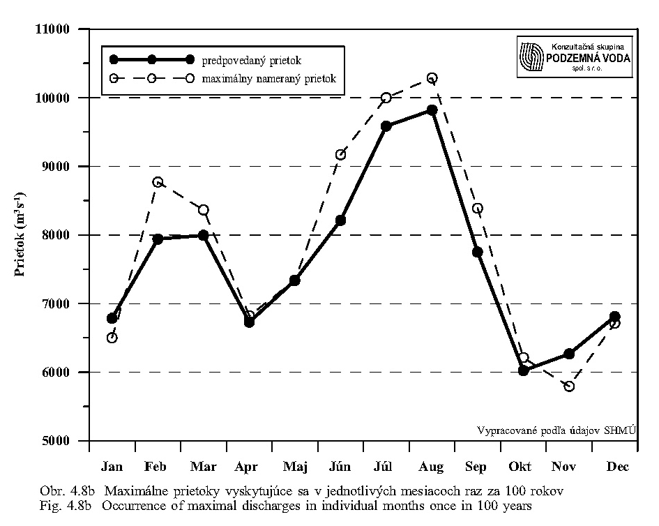
It is important to maintain the course of filling end emptying of the flooded territory (Fig. 4.9). The curve of filling can be steeper; i.e. the filling can be shorter. On the contrary, the curve of emptying must be flatter and continuous, i.e. the emptying of the flooded area must last longer so that it makes possible hatching of the laid spawn and floating of the young fish from the inundated area. The concrete date about the term of beginning and lasting of floods should be harmonised with the temperature regimen in the floodplain:
|
spring flood, filling at the temperature of the inflow water of 4°C, start of emptying after the water temperature in inundation has reached 15°C; |
|
|
summer flood: filling at the temperature of the inflow water of 15°C, start of emptying after the water temperature in inundation has reached 20°C. |
The temperature and time limits should be verified and modified in regard to the changes that arose after the Danube damming and other measures. It is also obvious that the optimal flood will not occur every year.
Natural habitats in this study have the priority. It is obvious from the environmental viewpoint of preservation of values and specific features of the within-dike floodplain that the basic priority is the functioning floodplain from the viewpoint of flood protection. Without a functioning floodplain there cannot be preservation of the nature close biodiversity and ecological processes, which are typical in the territory defined as inundation, with respect to the specific hydrologic and ecologic features of this Danube stretch. For this reason, all other interests must be subjected to the fact that this territory is and will be irregularly inundated, and they must to contribute to the preservation of the nature close biodiversity and ecological processes when using this territory.
Optimisation of hydrological regime should approximate the natural state. When optimising the hydrological regime, we prefer to create a new eupotamal. Realisation of such a proposal would create conditions best approximating the natural state (Fig. 2.2). It is necessary to consider that previous straightening of the Danube and concentration of discharges into one fortified riverbed caused irreversible changes. Construction of the Gabčíkovo project made possible at least approximation of nature close state in the within-dike floodplain.
In regard to the historical development of the arms system, it is necessary to focus on the within-dike zone with a risk that communication of the water level in the Danube old riverbed with the arm system will not be reached. The deepened bottom of the Danube riverbed does not allow the water, without a sufficient impoundment, to escape from the riverbed and to inundate the within-dike zone at discharges as earlier. Because the water level in the old riverbed is lower than in the arm system, the riverbed acts as a drain draining water from the arm system. In the present situation there exists a possibility to use the original main arms of individual arm systems to overtake function of the main stream. It is desirable to obtain the optimal state with the minimal interventions and minimal manipulation with the water management facilities.
If the concept of a new complex and bilateral eupotamal is not accepted, optimisation of the hydrological regime will be problematic, in particular in the area of Istragov. Supplying of the arms with water has been not yet technically resolved. At present, the water gets into this system of aquatic biotopes through their downstream mouthing as a result of the backwater, caused by the confluence of the tailrace canal with the original riverbed. The arms in the vicinity of the tailrace canal, for instance, the Išpánsky Dunaj arm, are obviously supplied with the seeping ground water. However, the bottom downstream of the tailrace canal mouthing into the original riverbed is deepening. Therefore it can be expected that the backwater level in the old Danube will decline in the close future and communication of the water in the arms with the Danube will be reduced. This danger is rather serious because there are very valuable biotopes; shallow “lakes” and “lagunes” overgrown with reed (Phragmites) and reed-mace (Typha), which represented rich aquatic biotopes showing a high production and diversity, before the Danube damming.
Optimisation of the water regime could be realised by construction of a submerged weir (dam) in the old Danube, similar to that at Dunakiliti, at the level of the upstream gate of the Istragovské Rameno arm. This would raise water level and increase discharge into the Istragovské Rameno and Foki arms. The lower gate of the Istragovské Rameno arm could be closed. If the hydrologic conditions do not allow constructing the submerged dam in the proposed place, it could be shifted upstream, under the mouthing of the peripheral arm in Istragov. The preserved riverbeds of the connected arms would also make it possible to fill the Išpánsky Dunaj arm with water. This arm is mounting at the confluence of the tailrace canal into the Danube. The risen water level in the old Danube would allow filling the peripheral arm in Istragov and filling of the internal lagoons mentioned above.
Complex of measures in floodplain within-dike zone includes the following main parts:
|
Interconnection of individual arm systems in the floodplain so that a new stream will be created. It would allow preserving the heterogeneous water formations (arms, inundations lakes, lakelets, inundation puddles etc.) in the within-dike zone. |
|
|
Supply of the water for the new stream from the by-pass canal and/or from the Danube old riverbed upstream of Dobrohošť, for example by an submerged dam similar to that at Dunakiliti). |
|
|
Ensuring of the heterogeneous hydrologic conditions in these new stream formations, obtaining of a wide scale of flow velocity in individual types of arms by means of remediation of already vanished mouthings of mutually connected arms. |
|
|
Ensuring of the water level fluctuation in water formation, from the temporary denudation of some parts of the bottom to flooding of the floodplain within-dike zone. |
|
|
Providing of the coordination of the water level fluctuations with fluctuations of discharge in the Danube upstream of Bratislava. |
|
|
Connection of the ends of the arms (in several places) with the old Danube riverbed. |
|
|
To create conditions for reaching of high water flow velocities in the new main stream and its arms during the flood situations. This would flush the water bodies, would support erosion and sedimentation processes and transform the river arm banks in the within-dike zone and lower its terrestrisation as a consequence of the natural succession. |
|
|
If the aims mentioned above are to be achieved, it is necessary to set unambiguous priorities and to define basic limits resulting from these priorities for management of this territory (manipulation rules). (Priorities can be named, for example, in the following order: flood protection of the territory outside of the within-dike zone, natural functioning of ecosystem and nature protection, silviculture, recreation, etc., in the floodplain inside the within-dike zone). |
|
|
In reality, this territory is hydrologically a functioning floodplain. Therefore it is obvious that at high flood discharges in the Danube, it will be always naturally flooded. It is necessary to introduce and provide a regimen for the flooded area. This means, among other things, to inform all users that this area is flooded and the term of floods will not be set administratively, but it will correlated at each flood with the discharges of the Danube. The increase of water levels and some flooding of the area are always to be expected in this territory when the discharge in the Danube at Bratislava will exceed 4,500 m3/s. |
The overriding and most important function of the old Danube riverbed are to lead discharges, which cannot flow through the by-pass canal, arms (including the new stream) and floodplain surface in the within-dike zone during the increased and flood discharges. Outside of flood situations the old riverbed should not drain the ground waters in its vicinity, but just on the contrary, it should support the optimal ground waters level and its fluctuation. The old Danube can fulfil this task only if its water levels will be higher than the present ones and if they will sufficiently oscillate approximately at the level corresponding to discharges of 1300 m3/s in pre-dam conditions (1985-1989). The cheapest and most satisfying solution seems to be the submerged dams, which could be destroyed, to a certain degree and under defined conditions, by the extreme high floodwater. Their disadvantage would be the necessity to be reconstructed after larger floods. Under the presumption of leading a discharge of 4,000 m3/s through the by-pass canal it can be estimated that such a reconstruction would be necessary once every 15-50 years, according to the construction and the mode of management of the Danube riverbed. During the non-flood state, the sanitary, but variable discharge supporting (depending on arrangement of the arm system and its supply with water) fluctuations of groundwater table, would flow in the old riverbed.
There were several proposals. One of the acceptable proposals are shallow submerged dams in the form of a wide letter “V”, with a very small slope on the downstream side, completed with the existing and new groynes between them. Other solutions can be the some fortification of natural fords, low inflatable weirs, river meanders and other arrangement of the riverbed, or their combination.
The basic criterion for measures in the old Danube riverbed is obtaining of such water level, which could be considered as satisfying. Such a water level corresponded before the Danube damming, according to Slovak Environment Commission, to the discharge of 1,300 m3/s. It was a level, which was able to provide the groundwater table on a level supplying sufficient soil moisture for the root system of the forests trees in the within-dike zone. In regard to this requirement, there are several Slovak or Hungarian proposals for maintaining the water table in the old Danube. One of such proposals is also the proposal given in the „Report on Temporary Water Management Regime“ of the Working Group of Monitoring and Water Management Experts for the Gabčíkovo System of Locks“ (CEC, December 1, 1993). This proposal presents a solution consisting of 8 submerged dams (over flown dams) downstream of the Dunakiliti weir. These dams are given in the Table 7.1 and Fig. 7.1. Besides this, in order to ensure connectivity, the fish ladders are proposed between the Danube and arm system, Table 7.2 and Fig. 7.1.
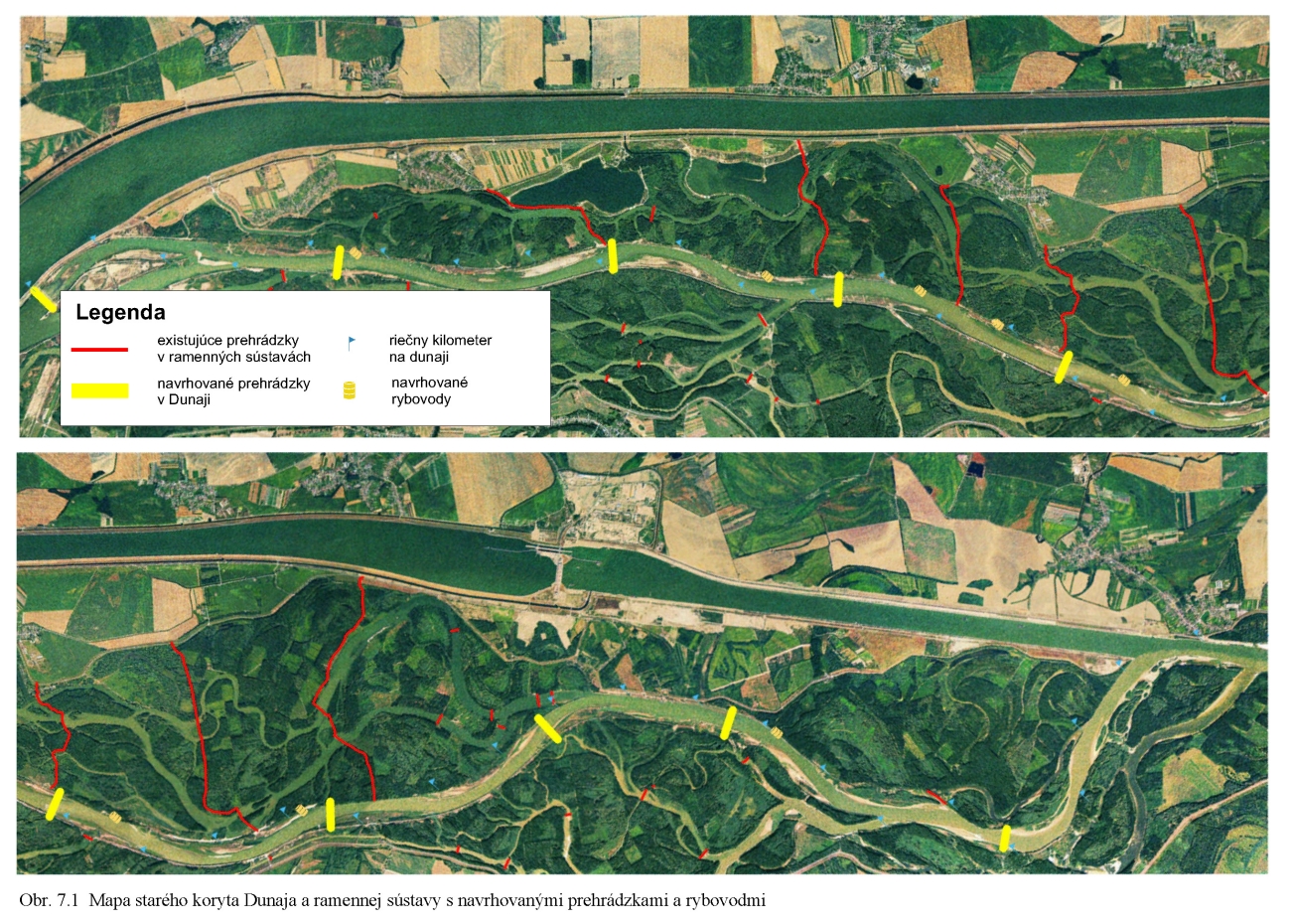
From this proposal only the simplified and incorrectly formed submerged dam at Dunakiliti was realised in accordance with the Agreement 1995 in the river km 1843, hence by 2 km more upstream than originally projected.
the Hungarian proposal given in the report elaborated at the Office of Premier Minister, Bureau of the Government Agent for the Danube called: Task of Analysis of Impacts for the Danube” presented to the Slovak side in December 1999 (Office of Premier Minister of the Hungarian Republic 1999) is also similar. This proposal is in Table 7.3.
Principally both proposals are identical and have the same aim – to connect the old Danube with the main arm and ensure that a part of water from the Danube flows into the arm, flow through this arm and then the water mouth back into the Danube and then again flow into an other arm, for example on the other side etc.
In both cases, the water table level would be regulated by discharge and an adequate shape of the submerged dams, according to the required fluctuation of water table and discharges. Principally it should have a “V” shape to enable sufficient fluctuation of water levels. The submerged dams should have a moderate slope (1 : 50) on the downstream side and should be constructed so that an extraordinary flood, exceeding some critical values would destroy such a dam or at least a part of it. The old riverbed should be permanently discharged and should be managed so that it can lead the required flood discharge. The arm systems should not be regulated except for the requirements of flood protection. It means a defined discharge and protection of the banks in meanders in the vicinity of the flood protection dikes and in the exactly defined places. It is necessary to calculate with flooding of the within-dike zone and with flowing of the water on the surface of this territory. Such a state is considered to be natural and to correspond with the basic functions of the floodplain.
Proposals to create a new eupotamal (partial or complete leaving of the old riverbed) and the shifting of the eupotamal function into one or more existing side arms had appeared already before finishing the Gabčíkovo project (Lisický, 1992). They were justified by the necessity to preserve the lotic conditions in the main stream of the Danube. Already after two first years of the Gabčíkovo project operation the monitoring of biota showed that the fear from the low ecological efficacy of function of the proposed puffer measures (see Chapter 6) were well-founded and confirmed the necessity of an essential alternative (Lisický, 1994, Lisický, 1995).
In the present situation, there is a possibility to use the original main river arms of the flood plain so that they simulate one of the Danube branches. In the past, before the water was concentrated into the one stream, the Danube water branched in this stretch into many arms and, in this way, the discharge was divided into several parallel flowing streams. The proposed solution would represent one of the branches of the main stream with adequately smaller discharge. From the viewpoint of the hydrobiological terminology, it would mean a shift by one order, when the former parapotamal-type arms would become the main stream (eupotamal). Subsequently the qualitative shift would also happen in other types of arms. The important factor in the flow created in this way would be providing of hydrological conditions ensuring that the discharge in the "new stream" will fluctuate in accordance with water table in a flow only slightly influenced by man. It means that the water table of the "new stream" would be manipulated by means of a new intake structure in correlation with the water discharge at a water gauge (for. example at the Devín village). At the highest discharges the water should spill and fill the adjacent water bodies, possibly also with the help of regulation of water level by means of cascades.
There is a tendency to obtain the optimal state by means of minimal interventions and minimal manipulation with water management facilities. In the initial stage, it would be necessary to deepen silted mouths of some arms to support their communication with the "new stream".
Lisický (2001) proposes to use the former side arms at restitution of meandering river pattern and a strong support of anastomoses. According to his proposal, the new eupotamal would cross the old riverbed at 4-10 places. It would allow leading larger discharges through the within-dike zone without dredging one dominant meandering riverbed. An argument for this (for the future) open solution is the fact, that we are not able to foresee unambiguously the character of the riverbed-forming activity of the river under the present local anthropogenous limits. Therefore it is not desirable to define a priori, how and where the new eupotamal should arise and how it should appear. It is probable that the water will use the existing well discharging arms in the initial stage, but later it will begin to re-model partly the floodplain at the flood discharges.
At such and similar solutions it is inevitable to propose and gradually realise the necessary technical measures in the old Danube. However, there is a question, to what degree such a scenario would be optimal for ensuring of leading the flood discharges and ice. The less radical solutions of this group are represented by the proposals to strengthen two parallel eupotamals in the main arms on both the Slovak and Hungarian sides without connection crossing the old riverbed (Šporka, 2001). This solution is also recommended by Lisický (2001) as a temporary acceptable alternative. However, the reasons for such function limits are not of the ecological nature, but of the political nature (existing state border and potentially different opinions of the Slovak and Hungarian sides about such solutions). But, even at such solutions the necessary technical measures in the Danube old riverbed are to be proposed and gradually realised.
Requirements to scenarios of optimal hydrologic regime solution with respect to the ecological demands
The arm system should have, first of all, the permanently flowing water in the main arms. The main arms should be connected with the old riverbed so that water flows into the arms in some places and flows out at other places in relation to the discharges in the Danube. Inlets and outlets should be at the places of backwaters in the old riverbed so that water flows several times into the arms and at the same time across the Danube old riverbed. It is also possible to form separately meandering arms on one ore both sides of the within-dike zone. The proportion of water flow between the old Danube and the meandering arm can be different (it was very different also at the beginning of the 20th century). The discharge in the main arm also depends on the aim we want to reach. The more water will flow in arms and the flow velocity will be higher, the higher will be erosion and sedimentation processes, the faster will be the process of moving of meanders, process of erosion, and forming of new riverbanks, the higher will be also demands for management of river arms in the vicinity of the flood protection dikes.
From the viewpoint of connection of arms, the fish ways, ladders, boulder passes, bypasses and other types of connection come into consideration. From the viewpoint of water table levels, the system of cascades able to provide flood simulation should be preserved or possibly modified. By means of closing and opening of culverts it is possible to regulate the processes of erosion and sedimentation.
The basic concept of arrangement of the within-dike zone, whose part is also the old Danube, follows from necessity to maintain the priority function of the floodplain to lead and temporarily retain the flood discharges. From this function the basic ecological concept to preserve the natural values of such functioning floodplain is also derived, of course, under the presumption that suitable conditions will be created for it from the viewpoint of hydrological regimen. Unlike the hydraulic structures in Austria and Germany, which were built up in the middle of the former floodplain and the water in the most arms flows slowly with small amplitude of water levels fluctuation, the floodplain at the Gabčíkovo structures has preserved its original function, as it had in the first half of 20th century. In this sense, the Gabčíkovo project is unique. Preservation of biotopes of such floodplain seems to be overriding from the ecological and practical viewpoint. It is realisable under the existing water management and technical conditions and construction of the Gabčíkovo project. Besides this it is possible to create, to a certain degree, hydrological conditions for disturbance and restoration of the autoregulative system in a part of the floodplain. This means mainly increase in spill out process, support of sedimentation processes and riverbed-forming potential, connection of the main riverbed with arms, making possible meandering of main arms, increase of ground water levels of the drained zone along the old Danube, support of fluctuations of discharges and water levels in the floodplain within-dike zone in correlation with discharges in the Danube, use of the intake structure at Dobrohošť, connection of the arms with the old Danube, etc. From the viewpoint of groundwater, it is desirable to increase fluctuation of the groundwater level, what can not be realised in the permeable alluvial gravel otherwise then by fluctuation of water table also in the old Danube riverbed. Therefore, the submerged dams (but also other technical facilities) must be formed so that they make possible, or create, such a fluctuation. The submerged dam at Dunakiliti serves as an example, which inhibits such a fluctuation.
It is evident, that such modifications of water regime, which are based on the dynamics of discharges and water levels, on support of erosion and sedimentation processes, and which result in the creation of conditions supporting disturbance and autoregulation of the system, need specific and accurately defined monitoring, monitoring criteria for evaluation of its results, and need an instrument (for example a permanently working mathematical model) for the water-management regulation of the hydrological regime dynamics. Subsequently, water-management, ecological, and other measures, inclusively of management of commercial forests should be carried out.
The floodplain within-dike zone should be able to lead and retain a part of floodwater and should be able to realise the natural and simulated flood. From this viewpoint it does not need any terrain rearrangements. The terrain works will be potentially necessary for flooding this area or for connection of the terrain depressions with the adjacent arms. If the Danube old river bed’s capacity to transfer the flood discharges will be curtailed, this function must be overtaken by the branch system and mainly the within-dike zone. This requires its maintenance and possibly creation of deforested corridors (meadows).
8. General conclusions, recommendations and proposals
Optimisation of water regime should approximate the natural state before closing and separating the Danube river arms from the main stream. From the ecological viewpoint it is desirable to create a new main riverbed/arm of eupotamal. Theoretically there are several alternatives, viz. creation of the eupotamal by connecting the Slovak and Hungarian systems of arms, creation of the new eupotamal only on the Slovak territory or creation of two eutopamals separately on the Slovak and Hungarian territory. In the case that creation of the new eupotamal by connection of the Slovak and Hungarian systems of arms (possibly using sections of the old riverbed) will appear as not real from any reason, then it is possible to consider creation of the new eupotamal only on the Slovak territory, according to proposal of Šporka (2001) or of two parallel ("national") eupotamals (Lisický, 2001). It would result in the relatively most natural state, close to the state before the beginning of construction of the Gabčíkovo project and before closing and separating the Danube River arms from the main stream. It is necessary to take into consideration that the previous works in the Danube riverbed made in connection with navigation, viz., straightening of its riverbed, fortification of river banks, concentration of discharges into the straightened riverbed, have caused changes which inhibit return to the original natural state, state when the Danube meandered freely nor, at least, to state from the middle of 20th century. Significant changes also have arisen due to construction of the Gabčíkovo project, but some possibilities to approximate the natural state in the floodplain arose too.
In respect to the historical development of the arm systems it is necessary to focus on the within-dike zone considering the risk that communication of the water table in the former arm systems will be reached only in some places or that the direct communication will not be reached at all. The deepened bottom of the old Danube riverbed and intake of water into the by-pass canal do not allow natural spilling of water into the inundation and it’s flooding, as extreme floods with discharges exceeding 8000 m3/s are an exception. However, the situation can be improved by means of technical measures.
From the viewpoint of the aims defined it is necessary first of all:
|
To provide creation of the "new stream" by means of connection of main arms of individual arm systems. It would allow preserving diverse water bodies (arms, lakes, flood lakelets, flood puddles etc.) in the floodplain within-dike zone. |
|
|
To restore already vanished mouthings of mutually connected arms (anastomoses) in order to obtain wide scale of flow velocities and diversified hydrologic conditions in these water bodies. |
|
|
To allow fluctuations of water table in the water bodies, from temporary denuding a part of the bottom to the flooding of these bodies at high water levels. |
|
|
To ensure the fluctuations of discharges and water level in the arms corresponding to the fluctuation of water level (discharge) in the Danube at Devín. |
|
|
To allow the water in the new main stream to reach high flow velocities in order to flush the riverbeds and, in this way, to inhibit their excessive terrestrisation resulting from the natural succession. |
|
|
In respect to the aims defined above, it is necessary to set the unambiguous priorities of management for this territory (its use for flood protection - leading of discharges, function of a polder, nature protection, silviculture, recreation etc.) and, on this principle, to elaborate manipulation rules of the integrated water management of the floodplain within-dike zone. |
A precondition for preservation of the communities close to the natural state (communities of natural character) and converging to the original state of the floodplain forests, as well as for reaching an acceptable state, is ensuring of flooding of a major part of the forest stands by the water from remnants of the arm system. This flooding must have a larger extent and duration than the hitherto practised simulated floods.
Therefore it is necessary to ensure floods in the entire area of interest, at which the water will flow (not only stagnate!) through the major part of forests at least for several days a year. For formation of the natural communities it is much more important to ensure more or less regular fluctuation of the ground and flood water in a relatively wide amplitude than to ensure a stable level of water table. For preservation of ripicolous and littoral communities it is also inevitable to ensure fluctuation of water table in the arms themselves, so that a part of their bottom and moderately declining banks is denuded for a longer time.
The discharge and water table in the main arms of the original arm system should be variable and must be correlated with the discharges in the Danube upstream of Bratislava. The water table in the lateral arms should be also variable. A stable high water level should not be maintained in them as it is practised at present over the major part of year. Diversity of water bodies (arms, meanders, depressions) also must ensure low water levels and allow water to heat and create conditions for balanced representation of fauna and aquatic vegetation of water table and shores. Most characteristic species of such communities do not tolerate a permanently high water level resulting in lower temperatures of water in the arms.
According to Lisický (2001), the old Danube is too capacious (and has heavy fortified banks) to the hitherto considered discharges (250, but also-600 m3/s at Čunovo), to be sufficient for the further forming of the entire riverbed. According to the hydrological typology, the main stream (eupotamal) has changed, as a matter of fact, on a side arm (parapotamal). Damming of the old riverbed and rising of its water table is necessary for reduction of its draining effect. From the ecosozological viewpoint it is acceptable only as a transition stage, until the time at which the eupotamal in the main arms of the original arm system starts to function. A functioning solution close to the natural state can be reached only by a gradual diversion of the present discharge from the old riverbed into the original arm system adapted for larger discharges. In such a state, the old riverbed would serve for leading flood discharges. It means restoring the anastoming and meandering river pattern in the new eupotamal, which existed here in the past and gradual leaving of the straightened and in the 20th century rearranged main riverbed with fortified banks. By means of a controlled succession, an autoregulative ecosystem could be naturally restored, which would correspond, in relation to the considerably lower discharge (for example according to Agreement 1995), to the Danube stretch upstream of Bratislava. At the same time it is necessary to refrain from the requirement of navigation in the Danube old riverbed, which is not ensured in any other hydraulic structure on the Danube (For the present moment the navigation is technically possible between Čunovo and Dunakiliti with possible passing downstream of the Dunakiliti weir and from Sap upstream up to the port of Gabčíkovo). After providing a sufficient discharge in the new riverbeds, it will be possible to allow for the gradual terrestrisation of the not functioning stretches of the old riverbed, under condition of preservation of its function for leading large flood waters.
The hydrologic regimen itself is not sufficient for return to the natural state. It represents only an inevitable precondition. Out of modification of the management of the hydrologic regime, it is necessary to change essentially the approach of silviculture and local population to the landscape use. First of all it is necessary to prevent the gradual urbanisation of this territory and its fragmentation by a network of forest roads, intensively used plots, recreation facilities etc. A pre-requisition of this is maintaining of an intern regime of naturally or artificially flooded area and a regime corresponding to the Protected landscape area, in some places a regime of Nature reserves or at least of the special purpose forests. Without this, the realisation of the water management measures will be effective, but its effect will be devaluated by other human activities. Also for this reason, it is necessary to strictly insist on elimination of any activities, which are in contradiction to the character of a floodplain.
The basic scenario
For the more detailed final discussion and realisation of modelling of the scenarios of further policy we recommend the proposals belonging to the "new eupotamal" group. They are most promising from the viewpoint of restoration of the natural processes and autoregulation of the ecosystem. Therefore only individual varieties of this group of scenarios are to be completed and their suitability is to bee evaluated. For their realisation they need, as the first step, to rise of the water table in the old Danube by means of submerged dams or damming the riverbed on several places and construction of hydraulic guide structures across the old Danube. The proposal to dredge one dominant side arm, which also belongs to this group, is laborious, expensive and problematic from the view of flood protection, extent of earthworks and maintaining of the riverbed in the floodplain. In addition, it contradicts to the concept of supporting the natural riverbed-forming activity of the chosen arms and of inhibiting excessive facing of their banks. From the discussion about individual scenarios it follows that the solutions presuming creation of a new eupotamal, as schematically proposed in Fig. 8.1, are most functional and optimal from the view of ecology and ecosozology. The complex Slovak-Hungarian solution, which would restore a unique system in this stretch of the Danube, is preferred. In the case that modelling or other reasons (i.e. other than ecological reasons) would show its unreality, the second preferred solution is creation of two parallel eupotamals along the both sides of the old Danube. From the practical aspect of leading of flood discharges, the most acceptable way seems to be creation of a new eupotamal using temporarily submerged weirs in the places where the new eupotamal should cross the old Danube. Such solution preserves the function of leading of flood discharges, reduces draining effect of the old riverbed, and will work with a small (variable) discharge in the old riverbed until the new eupotamal in the main arms of the original arm system will have started its work. The new eupotamal should be created so that it does not need maintaining of its riverbed and fortification of banks.
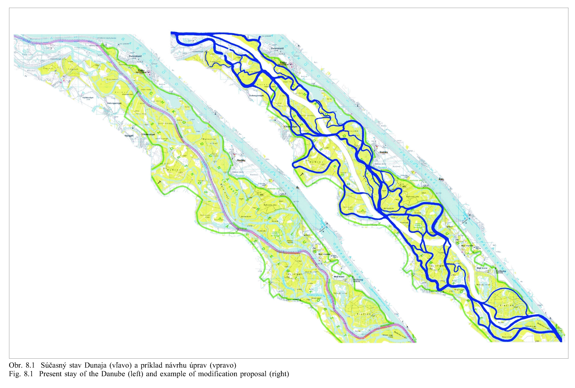
If we accept the principle that arrangements should be non-violent, carried out on the limited areas in the within-dike zone, inexpensive, requiring only limited earthworks, and that they should converge to natural processes, then there exists a combination of proposals and sequence of works. An advantage of this sequence is also a chance to correct the course of works on the base of environment monitoring. The sequence of the works would be arranged as follows:
|
construction of several low overflowing dams (similar to the one at Dunakiliti) making possible to connect the arm system with the old Danube at several places; |
|
|
providing of a natural dividing of water between the old Danube riverbed and the connected arms; |
|
|
optimisation of discharges in the arms in relation to dams and water dynamics in the arms; |
|
|
rearrangements leading to restoration of the natural processes in an autoregulative system, inclusively of the dynamics of discharges and levels of the surface and ground water, erosion and sedimentation, meandering in the within-dike zone and mutual connection of arms; and |
|
|
monitoring of functionality of several, at the beginning 2-3, low overflow dams constructed in the old Danube and on the base of its result proposing further arrangements, for example fortifying of fords, connections between arms, changes in water levels, etc., gradual building of further overflowing dams in the Danube. |
In respect to the unsatisfying quality of the necessary historical data and lack of experience with rehabilitation, up to restoration of a river in a similar scale and in a comparable environment there exists a question of preliminary modelling of expected processes (erosion, sedimentation, water quality, influence on ground waters etc.). In regard to a great heterogeneity of parent rocks, sediments and geomorphology, creating of a reliable model would be probably expensive. On the other hand, there is some experience with modelling of the processes in the Čunovo Reservoir and in its vicinity, experience from other countries as well as new investigative methods, which can make the modelling process considerably easier. It will be desirable to model mainly those parts of the new solution, which require some technical measures, for example verification of passing of floods and ice and, step by step, also of the entire large area experiment. It is also possible to model the erosion-sedimentation phenomena. Results of such model are quite well. There is only the question whether they will apply in praxis, where the situation depends on real discharges and time frequency of floods. Modelling is a process, which, based on the monitoring, models the proposals and contributes to the decisions and realisation of the proposals. The monitoring continues, the results are compared with the model, the model is corrected and a new phase begins – correction of the proposals. It is an iterative process, which can be used in the course of works. One of main lessons from the Austrian stretch of the Danube is the fact that the modelling is not able to offer the final solution already in the initial phases and to foresee the concrete events. Because the modelling is a process, it is necessary to divide the proposal into subsequent steps, to model them and to monitor the results and by means of the gradual steps to refine and correct the proposal. It can be stated that some failures of the modelling do not result from the modelling method, but from the insufficient knowledge of parameters input in the models.
From this reason the experts, who compiled this study, endorse the idea of gradually controlled (by means of the technical measures and water management) releasing of the river dynamics in the area of interest according to the scenario proposed in the conclusion, and endorse the principle of gradual adaptive decision-making oriented to the gradual optimisation of the hydrological regimen in the next decades. The basic concepts of this optimisation are expressed in the previous chapters. At the same time they recommend to realise as few technical measures as possible in the arm system and to allow nature and natural processes to create the new eupotamal.
The available water sources
The previous considerations show that there are principally two water sources:
1. Water from the Čunovo Reservoir:
- On the left side of the Danube old riverbed (the Slovak part of the arm system) it is the water from the by-pass canal inflowing into the arm system through the intake structure at Dobrohošť. Its amount can be regulated in a wide range of 0 to 240 m3/s.
- On the Danube right side (the Hungarian part of the arm system) it is the water from the Čunovo Reservoir from the intake structure leading water into the Mosonyi Duna with the capacity up to 40 m3/s and water from the seepage canal.
2. Water from the old Danube, whose total quantity ranges, according to the “Agreement” from 1995, from 250 to 600 m3/s. During the flood discharges, its amount can be much larger, theoretically more than 10,000 m3/s. According to the proposal of the Hungarian side from 1999 (Office of the premier minister of the Hungarian Republic 1999) based on the opinion of five Hungarian institutions, which defines the ecological-technical concept, the explicitly defined ecological minimum of the discharges in the old Danube in the growing season is 400 m3/s, while in winter 20-40 m3/s. Water sources are:
- On the Hungarian side the water from the old Danube is connected with arm system directly by inlets situated upstream of the Dunakiliti weir. In summer 100-300 m3/s water flows into the arms.
- A overflow dam, similar to that on the river km 1843 at Dunakiliti, constructed at Dobrohošť would make possible to supply analogically the Slovakian arm system directly from the old Danube.
It is evident that both the basic water source, the water from the Čunovo Reservoir and the by-pass canal and the water from the Danube old riverbed, are available and can be mutually combined.
The solution presumes several varieties. The optimal and most functional variety, from the viewpoint of ecology and ecosozology, seems to be the solution presuming creation of the new eupotamal in the main arms of the present floodplain. We prefer the complex Slovak-Hungarian solution, which would restore the unique ecosystem in this stretch of the Danube. The second preferred solution is creation of two parallel eupotamals on both sides of the old riverbed.
These two varieties presume to connect the water of arms with the old riverbed downstream of the Dunakiliti weir, for example by means of submerged dams. Furthermore they presume two alternatives – one common Slovak-Hungarian eupotamal crossing the old riverbed in several places or two separate eupotamals, each on one side of the Danube, not crossing the old riverbed. Decision about one of these alternatives does not exclude accepting later another alternative or to solve the situation on one side of the Danube only.
Beside this, the intake structures for Mosonyi Duna at Čunovo and for the Slovak arm system at Dobrohošť will remain functional. In the Slovak side it will be possible to reduce the water amount inlet through this intake structure and to use it for a complementary control of discharges in the arms and for the simulation of floods.
The old river bed, obviously in a rearranged form, will retain its function of leading the flood discharges, hence leading of those discharges which can not flow through the by-pass canal, arm systems and, at higher discharges, through the entire floodplain zone. In the non-flood situations it will lead the sanitary discharges or it will be changed into a riverbed with low submerged weirs and impounded sections. These intermittently flowing and stagnant sections may be used e.g. for sports navigation. In any case it is necessary to calculate, and maintain its flood protections function.
The main kind of arrangements in arm systems is their transformation to discharging arms of the eupotamal type, which will form a new river. One of the possible proposals, for example, is represented in Fig. 8.1. Of course, the scheme can look otherwise. Principally it is a functional solution close to the natural state, which will be obtained by the gradual diversion of the discharge from the old riverbed into the original arm system, adapted step by step for the required discharges. It means restoration of the anastoming and meandering river pattern, which existed here in the past, and the gradual leaving of the canalised old riverbed of the Danube whose transformation was finished in the past century.
Sequence of works
In regard to the existing experience and information from Austria, all realisation steps should be modelled in advance, step-by-step realised, and, at the same time, step-by-step monitored. One of the possible alternatives is, for example the following:
|
Elaboration of the proposal for connection of the old riverbed with the future arm of the eupotamal type, verifying the solution by means of modelling and elaboration of the project, |
|
|
Construction of the submerged dam somewhere between the river km 1838 (Vojka) and 1840 (Dobrohošť), |
|
|
Construction of a sill and groyne in the inlet canal at the sluice at Dunajské Kriviny. |
|
|
Connecting the Vojčianske Rameno arm by means of an inlet (opening) in the banks with the backwater in the Danube old riverbed. |
|
|
Construction of a dam in the river km 1830 at Bodícka Brána (or r. km 1828.35 downstream of the present line E or in r. km 1831.70 downstream of the present line C or in the r. km 1834.90 downstream of the present line B) upstream of which the new eupotamal could cross the Danube old riverbed and conceivably intake there more water from the old riverbed. |
|
|
Monitoring of the changes arising after the construction of dam and processes in the arm, mainly the relation between erosion and sedimentation, transformation of banks, etc. |
|
|
To leave the sanitary discharge in the old riverbed and to adjust it for transferring the flood discharges. |
|
|
Evaluation of changes and processes, implementation of the results into the model, repeating of the models. |
|
|
Evaluation of results of previous works and proposal of further course of the works. |
9. EPILOGUE
In this study, which provides qualitative and logic-based analysis of complex environmental assessment of problems, goals and possibilities, we tried to present a vision of how the floodplain between the flood protection dikes of the Danube old riverbed in the stretch between the Dobrohošť and Sap villages should look from the viewpoint of flood protection and natural functions. This vision is based on the knowledge of a large group of experts. Their ideas are presented, cited and summarised in the vision. They represent a scientific background of opinions and interpretation of monitoring of natural environment.
It is evident that the proposed state cannot be obtained, at once and quickly. Gradual steps are presumed, with minimal technical interventions and minimal regulation works. The results of this effort do not depend only on water management measures, but also on different decisions of different levels, from the international negotiations to the local authorities and individuals. However these aspects are not the topic of our study. The study does not insist on the strict respecting of all opinions, but it proposes an aim, which can be reached just by the gradual steps, discussion and application of monitoring and interpretation of its results. The authors expect that all proposals and projects will be first professionally discussed, modelled, and after their realisation monitored, evaluated and gradually completed so that they lead to the filling of the vision proposed.