V.1.6. Changes of the Danube river channel capacity at medium and flood discharges in the stretch Čunovo – SapKatarína Holubová, Zuzana Capeková Specific hydro-morphologic conditions of the Danube stretch downstream from Bratislava formed, during a long period, a unique anastomozing area with high morphological diversity, which is characterized by a system of side arms (of streams, branching and rejoining irregularly to produce a net-like pattern), interconnected with the main channel [1], (Fig. 1a). It is an extraordinarily valuable floodplain ecosystem, where rare species of fauna and flora occur. The aim of the previous long-term regulation of the riverbed for navigation (straightening of the main river channel, heavy fortification of banks, dredging of fords, groin system) was canalisation of the river and concentration of discharge into one main channel. The lateral development of the riverbed was strongly limited and morphological changes were manifested particularly in the riverbed, in the form of aggradations (fords) or degradation. Cutting off the side arms from the main channel significantly limited interaction of their waters (Fig. 1b). Further significant interventions into the morphological development of the Danube are bound with construction and operation of the Gabčíkovo project, which shifted the navigation out of the river, lowered discharges and thus influences flow dynamics and essentially determine the regime of sediment transport [1]. In the past, the aggradation of the Danube riverbed predominated for a long time [4]. It was caused, first of all, by distribution of discharges into many arms downstream of the granite threshold at Bratislava. Actually, since the beginning of the Danube regulations made in order to protect adjacent areas against floods and provide conditions for navigation, the aggradation slowed down and, gradually, after concentration of waters in the single channel it turned into the erosive process and cutting down of the river bed. Long of before the Danube damming, the longitudinal profile of the Danube in the stretch Devín – Sap was already completely under the influence of erosive process (incision of riverbed) caused by training and commercial dredging. The water levels in the main channel, in the river arms and groundwater levels follow this decreasing trend. After the Danube damming at Čunovo, the discharges in the Old Danube considerably decreased and there arose a deficit of sediment intake. This resulted in changes in the riverbed, changes of discharges in the side arm system and in the water level regime. The permanently lowered water levels support a gradual overgrowing of banks and of a part of the Old Danube by dense vegetation. Interaction of surface waters is limited to periods of releasing of flood discharges. The arm system on the Slovak side is supplied with water by the intake structures at the bypass canal and on the Hungarian side from the Čunovo weir and upstream from the submerged weir at Dunakiliti. Changes of hydro-morphologic conditions and river channel capacity of medium discharges The reservoir and weir at Čunovo is a barrier for fluent transport of sediments. Almost all sediments, which are transported through the Slovak-Austrian stretch of the Danube, are deposed in the impoundment zone. Thus, the Danube in the stretch Čunovo-Sap can be considered as a “passive stream” from the morphologic viewpoint [3]. At present, changes in the riverbed are conditioned almost wholly by bedload transport within the section of the Old Danube, which sets in movement only at high discharges. The extent and intensity of these changes depends on the size of discharges, their frequency and duration. In the time of releasing the flood discharges throughout the Čunovo weir, a strong disequilibria between bed load and stream transport capacity arises in the Old Danube. Different flow dynamics downstream of the Čunovo weir and upstream of the confluence with the tailrace canal divides the Old Danube into stretches upstream and downstream from rkm (river kilometre) 1822. Upstream rkm 1822 there is no backwater effect and the sediment transport is influenced by the permanently decreased discharges and only seasonally increased discharges. The stretch downstream from rkm 1822 is, in addition, frequently under the influence of backwater from the tailrace canal. Development of the longitudinal profile of the Old Danube riverbed in the period 1989-2001 is shown in Fig. 2. As to morphological changes of the bottom, the stretch upstream from rkm 1822 is divided into:
The decreased flow velocity, the backwater, and the morphologic development of the Danube riverbed in the stretch downstream from confluence at Sap influence transport of sediments downstream from rkm 1822. This section of the Old Danube is influenced by backward erosion from confluence with the tailrace canal in spite of the fact that flow energy declines here (backwater). The incision of the riverbed is mostly manifested in the area of confluence and decreases in the upstream direction. Changes of the riverbed morphology also contributed to a change in discharge capacity of the Old Danube. Comparison of the fixed water level (1987) with the simulated water level (2001) at the same discharge of 2370 m3.s-1 shows that the changes in water level are manifested in both dynamically different areas (Fig. 2). In the backwater area between rkm 1810 – 1816 the water levels decreased. This decrease of water level of medium channel discharge resulted from the backward erosion of the riverbed (increased channel capacity). The maximum decrease of the water level – 50 cm occurred in the upstream direction. No significant changes of the water levels occurred in the section between rkm 1816 and rkm 1823. In the section between rkm 1823 and rkm 1842, a relatively significant increase in water levels occurred, which reaches the maximum values of 92 cm at the given discharge (rkm 1828). Changes of the Old Danube capacity vary along this section. However, the river channel capacity for bankfull discharge decreased by approximately 8% when compared with the pre-dam state. Relatively significant increase of the water levels in the section of r. km 1826-1838 is caused by synergic effect of morphological changes and littoral vegetation, a part of the riverbed is overgrown by dense vegetation. Therefore it was presumed that the roughness of the river channel would be considerably higher than before the damming. Influence of increased roughness was also partly manifested in a change of the flow resistance coefficient. As the values of the resistance coefficient also include other irregularities of the riverbed (narrowing or widening of the stream, groin systems, riverbed adjustments etc.), it is not possible to explain these changes only by vegetation growth in the river channel. Comparison of values of the resistance coefficient k (Fig. 3) from 1960s (VITUKI) with values derived from the fixed water levels (09/2001) indicates only a moderate shift to the lower values (increasing of roughness) in the area without the backwater effect. Overgrowing of the Danube riverbed itself has a certain influence on the change of the river channel capacity at medium waters. The permanent maintenance of the riverbed or increasing of water level by low over-flown weirs would minimize growth of vegetation and its contribution to increased risk during flood discharges. Changes of the river channel and floodplain capacity of flood discharges The course of the flood in August 2002 indicated the significance of vegetation changes in the floodplain on the water level regime. During the flood in August 2002 (max. discharge at Devin = 10390 m3s-1) a discharge Q = 6590 m3s-1 was released into the Old Danube. At that time the water level in the stretch downstream of Rajka (rkm 1848.33) to rkm 1822 reached the level of the water level Q100 established in 1977 (without influence of the Gabčíkovo structures). In the lower part, downstream from rkm 1822 to Sap, the water levels were by about 0.5 m higher than levels corresponding to that discharge (Fig. 4). The safety overtop of dikes over the level Q100 is 1.5 m in the stretch downstream from Rajka to rkm 1835, while 1.2 m downstream from rkm 1835. The course of the flood in 2002 showed relatively significant changes in the area of side arm system in the within-dike zone, which unfavourably influenced the flow of flood discharges. Therefore a detailed analysis of flood discharge regime was done. On the basis of agreement of Slovak and Hungarian experts of Commission of Boundary Waters (SH CBW), the water levels for discharges Q100 and Q1000 at individual gauging profiles in the stretch Čunovo – Sap as well as for the subsequent stretch Sap – Szob were set. The values of discharges Q100 (10600 m3s-1) and Q1000 (13400 m3s-1) were predefined by the Slovak Hydro-meteorological Institute and EDUKOVIZIG and mutually confirmed. For calibration of the numeric model the fixed water level of the flood discharge from August 2002 was used and simulations were done for steady nonuniform flow conditions. The courses of water levels estimated for Q100 and Q1000 for the case of distribution of discharges between the bypass canal and the Old Danube, and for the case of releasing the whole discharge into the Old Danube are given in Fig. 4. Evaluating the water level for Q100 and under the assumption that the whole discharge Q100 would be released in the Old Danube, the safety overtop of the dike is not maintained in the stretch downstream from rkm 1839 down to the mouth of the tail-race canal. The old dike (protecting the villages Dobrohošť, Vojka and Bodíky) would probably overflow in the stretches between rkm 1828-1834 and 1820-1816. Assuming a distribution of flood discharges between the bypass canal and the Old Danube, the water level for Q100 would be higher than the originally set level and from rkm 1836 down to the confluence with the tail-race canal (Fig. 5) the dike safety overtop would not be maintained. At releasing of the discharges Q1000 without distribution of discharges between the bypass canal and the Old Danube, the water level would reach considerably above the dike top almost in the whole stretch, downstream from rkm 1839 to confluence with the tailrace canal. The situation would not significantly change even in the case of flood discharge distribution. The preliminary evaluation of the water level regime of the flood discharges in the Danube side arm systems shows that the course of the water levels has significantly changed, due to the changed discharge conditions. These changes are influenced by several factors: overgrowing of the Old Danube by dense vegetation, missing maintenance, reduced discharge capacity of the inundation and the river arm system, lower discharge capacity of the Danube downstream the confluence with tailrace canal and higher backwaters in the lower part of the territory because of not fulfilling the Joint Treaty Project, etc. From the viewpoint of providing the necessary flood control, the most critical stretch is the downstream part of the river arm system, from rkm 1822 down to confluence with the tailrace canal (Fig. 5). Assuming a distribution of the flood discharge between the bypass canal and the Old Danube, the most critical stretch is between rkm 1835-1818. Summary The regulative measures focused on improvement of the discharge capacity of the Old Danube and the floodplain area in the stretch Čunovo – Sap (removal of vegetation from inside of the Old Danube river channel, floodplain maintenance, mowed meadows in the floodplain, adjustment of the river channel capacity, etc.) can provide a good reduction of water level during flood events (Fig. 4). The course of water level in the lower part of the arm system and in the area at Sap is influenced by changes of the floodplain area (floodplain shape, vegetation overgrowing, retention, human impacts), hydrological coincidence of flood discharges downstream of the confluence (tailrace canal and the Old Danube) and backwater effect upstream of Medveďov bridge profile. The results indicated that the most evident increase of flood water level propagates upstream of Medveďov, thus improvement measures should concentrate not only at the Old Danube floodplain but also at this river section. These questions are solved at present although complexly, in close collaboration with the Hungarian specialists. References
V.1.7. Monitoring of the suspended load regime in the DanubeMária Borodajkevyčová Natural surface streams characteristically have a non-uniform and heterogeneous flow and discharge regime. Transformation of the riverbed morphology depends on the width and depth of the stream, flow velocity, water level gradient, riverbed roughness and bed load and suspended load sedimentation and erosion. The bed load consists of sandy grains and gravely pebbles shifted by the river on the bottom. The Danube, after its rise in the Ice Age since the Mindel period, created a large gravel-sandy alluvial fan downstream from Bratislava, which is sometimes called inland delta. Suspended load consists of particles or grains of different size, weight and shape, of different physical, chemical and petrographical composition, floating in the flowing water. At a decline of flow velocity, a part of them settle and some of these continue to move on the bottom as bed load, while the smaller grains continue to float in the water. The Danube after its straightening, riverbank fortification, and transformation into a navigation canal in the late 19th and in the first half of 20th Century, transported 2-8 millions tons of dispersed solids a year [1]. In consequence of the flow and geomorphologic conditions, a major part of the transported suspended load has deposed as alluvial loams and sands of floodplain deposit facies and as sediments in river arms and river stretches with a slowed down flow. Measurement of sediment transport in the Danube at Bratislava – in the past and today The construction of 28 among 38 projected hydraulic structures in the stretch between Ulm and Freudenau has changed the conditions for transport of sediments. The bed load and a major part of the suspended load are deposed in backwater stretches upstream of the hydraulic structures. The Water Management Research Institute carried out the first systematic direct measurement of suspended load transport in the Slovak stretch of Danube in 1950-1960s [for example: 2, 3, 4]. New interest in sediment transport in the Danube began in the early 1990s, in the frame of prognoses of sedimentation in the Hrušov reservoir (at present called Čunovo) of the Gabčíkovo hydropower project for different alternatives of reservoir arrangement. The staff of the Water Management Research Institute resumed direct measurements of the suspended load in more profiles in the Danube in 1992-1993 in the framework of the PHARE project “Danubian Lowland Groundwater Model”. The last activity in the field of a complex investigation of sediment transport in the Danube was the scientific-technical project “Investigation of regime of bed load and suspended load in the Danube in the area of the capital in changed discharge conditions”, which was completed at the Water Management Research Institute in 1995-1999. The regular monitoring of suspended load by the Slovak Hydrometeorological Institute started in 1992. In the whole Slovakia, the suspended loads are monitored by 17 gauging stations; in the Danube at the profiles in Bratislava, Medveďov and Komárno. Results of suspended load measurement in the Danube at Bratislava Monitoring of suspended load in the Danube started at the Water Management Research Institute in 1952. The samples were taken at the left, later at the middle field of the road and railway bridge in Bratislava (the Old Bridge), Fig. 1. Results of measuring the suspended load carried out by the Slovak Hydrometeorological Institute at the gauging station in Bratislava, and evaluated since 1993, are given in Fig. 2. The daily sampling was done at the left riverbank, at the profile of the gauging station, and twice a year samples of suspended load were taken by the integration sampling method from the whole river profile. The samples were processed in a laboratory by the filtration method according to Standard ČSN 830 530 “Chemical and physical analysis of surface water”. Tab. 1. Measurements by the Water Management Research Institute, Station: Bratislava – middle field of road and railway bridge
Tab.2. Measurements by the Slovak Hydrometeorological Institute, Station: Bratislava – left riverbank of the Danube, gauging station
Comparison of the Water Management Research Institute results from 1952 to 1958 and the Slovak Hydro-meteorological Institute results from 1993 to 2004 shows that all values given in Tab. 2 are half as large as the values in Tab. 1. The report of the project completed in the Slovak Hydrometeorological Institute in 1995-1999 stated that discharges of suspended load and annually transported amounts were much larger in 1933-1960 than in the newer measurements (Fig. 3). By integrating all field measurements of suspended load (historical data of the Water Management Research Institute and the Slovak Hydrometeorological Institute) we get the diagram presented in Fig. 3. This data series is not homogenous (especially with regard to the technology of measurement and processing), but it gives an approximate image about the regime of suspended load for a relatively long period. Evaluation of regime of suspended load in three gauging stations in the Danube The transport and sedimentation processes running in the stream are best illustrated by the annual discharge of suspended load at different profiles along the stream. The results of measurements at Bratislava Medveďov and Komárno profiles are in Fig. 4. The Fig. 4 shows that Bratislava has the highest values of the annual discharge of suspended load in the Danube. Less suspended load flows through the profile at Medveďov, due to their partial sedimentation in the Čunovo reservoir. In the stretch between Medveďov and Komárno, the discharge again decreases as a consequence of the low slope of the Danube riverbed. A typical example characterizing sedimentation of suspended load are the years 2002 and 2003. In 2002 two floods occurred, as well as an extraordinarily high average annual discharge. The year 2003 had an approximately average annual discharge, while the year 2004 had a below-average discharge (see Bačík in this publication). Comparing the annual average discharges of suspended load shows that the decline of suspended load along the Danube downstream from Bratislava (in the Čunovo reservoir and in the stretch Medveďov – Komárno) is minimal in the years without flood discharges, and also at average and below-average water discharges, and this all since putting the Freudenau hydropower station into operation. Summary The conditions for the existence and development of erosion and sedimentation processes, and transport of suspended load and bed load have considerably changed in the Danube downstream from Bratislava in the last half-century. As shown by a series of measurements carried out by the Slovak Hydrometeorological Institute, the transport of suspended load strictly depends on water discharges. Sedimentation of suspended load in the Čunovo reservoir also depends on the discharge. In the years without an occurrence of higher discharges, the sedimentation of suspended load in the Čunovo reservoir is minimal to insignificant because that part of suspended load which could settle (correspondingly to its grain size) in the Čunovo reservoir, had already settled in the backwater stretch of the Freudenau hydraulic structure, and in the Danube and its arms upstream of the granite threshold in the Danube at Bratislava. These data could support the manipulation of discharges, stream velocities, and water levels in the Čunovo reservoir, and the manipulation of discharges in the arm system. References
|
|||||||||||||||||||||||||||||||||||||||||||||||||||||||||||||||||||||||||||||||||||||||||||||||||||||||||||||||||||||||||||||||||||||||||||||||||||||||||||||||||||||||||||||||||||||||||||||||||||||||||||||||||||||||||||||||||||||||||||||||||||||||||||||||||||||||||||||||||||||||||||||||||||||||||||||||||||||||||||||||||||||||||||||||||||||||||||||||||||||||||||||||||||||||||||||||||||||||||||||||||||||||||||||||||||||||||||||||||||||||||||||||||||||||||||||||||||||||||||||||||||||||||||||||||||||||
|
[1] |
Agreement 1995: Agreement between the Government of the Slovak Republic and the Government of Hungary about Certain Temporary Measures and Discharges to the Danube and Mosoni Danube, signed on April 19, 1995. |
|
[2] |
Bajcar, V. et al., 2005: Monitorovanie lesných ekosystémov v roku 2005 pre potreby plnenia medzivládnej Dohody z 19. apríla 1995. Správa za rok 2005. Výskumný lesnícky ústav Zvolen, Výskumná stanica Gabčíkovo, 2005 |
|
[3] |
Fulajtár, E., Barančíková, G., Miklovič, D., 2003: Súhrnné hodnotenie monitoringu poľnohospodárskych pôd v oblasti vplyvu VD Gabčíkovo za obdobie 1989-2002. Súhrnná hodnotiaca správa. Výskumný ústav pôdnej úrodnosti, Bratislava |
|
[4] |
Fulajtár, E., Dodok, R., Miklovič, D., 2006: Monitorovanie poľnohospodárskych pôd v oblasti vplyvu VD Gabčíkovo v roku 2005. Výročná správa. Výskumný ústav pôdnej úrodnosti, Bratislava |
|
[5] |
Matečný, I. et al., 2005: Monitoring prírodného prostredia dotknutého výstavbou a prevádzkou VD Gabčíkovo – odborná skupina biota. Správa za rok 2005. Prírodovedecká fakulta Univerzity Komenského, Bratislava |
|
[6] |
Mucha, I., Rodák, D., Banský, Ľ., Hlavatý, Z., Kučárová, K., Lakatosová, E.: Monitorovanie prírodného prostredia v oblasti vplyvu VD Gabčíkovo. Súhrnné správy za roky 2002, 2003 a 2004, Konzultačná skupina Podzemná voda spol. s r.o., Bratislava |
|
[7] |
Národná ročná správa z monitorovania prírodného prostredia na slovenskom území za roky 1997-2004 podľa Dohody medzi vládou SR a vládou MR o určitých dočasných opatreniach a prietokoch v Dunaji a Mošonskom Dunaji, podpísanej dňa 19.apríla 1995. Konzultačná skupina Podzemná voda spol. s r.o., Bratislava |
|
[8] |
Mucha, I., Kocinger, D., Hlavatý, Z., Rodák, D., Banský, Ľ., Lakatosová, E., Kučárová, K., december 2004: Vodné dielo Gabčíkovo a prírodné prostredie, súhrnné spracovanie výsledkov slovenského a maďarského monitoringu v oblasti vplyvu VD Gabčíkovo, Splnomocnenec vlády SR pre výstavbu a prevádzku sústavy vodných diel Gabčíkovo-Nagymaros, Konzultačná skupina Podzemná voda spol. s r.o., Bratislava |
|
[9] |
Joint Annual Report: Joint Annual Report on the environmental monitoring in 1995 (1996, 1997, 1998, 1999, 2000, 2001, 2002, 2003, 2004), according to the ”Agreement between the Government of the Slovak Republic and the Government of Hungary about Certain Temporary Measures and Discharges to the Danube and Mosoni Danube”, signed on April 19, 1995 |
V.1.9. Monitoring of ground water regime in the area of the Gabčíkovo Project
Ján Gavurník
The Slovak part of monitoring and evaluating the ground water regime covers the Žitný Ostrov Island, as well as the right- and left-bank parts of Bratislava. The Slovak Hydro-meteorological Institute performs the monitoring in the framework of its all-Slovakia basic monitoring network. This network is completed in the area influenced by the Gabčíkovo hydraulic structures by a special secondary monitoring network. The secondary network consists predominantly of objects having been included into the monitoring in 1980. A considerable number of these objects are also included in the Joint Slovak-Hungarian monitoring of the environment. The aim of this contribution is to compare results of monitoring ground water levels before (1967-1987), and after putting the Gabčíkovo project into operation (1995-2004).
Monitoring network
During the period 1967-1987, more than 300 objects were monitored in the broad area of the Gabčíkovo hydraulic structures. Among them we selected 244 objects for evaluation, among which 3 objects were monitored daily, with the others in one-week intervals. In the period 1995-2004, 219 objects were monitored. However, we used for evaluation only 203 objects because of their satisfying our required length of monitoring. 120 objects were equipped with automatic devices; other objects were monitored by voluntary collaborators (Fig. 1a, Fig. 1b). The automatic devices measured the states of water levels in one-hour intervals, while the voluntary collaborators measured mechanically once a week. Using the 1-hour states, daily average values were calculated, which were used in further evaluation.
Main factors influencing the ground water level regime
The dominant factor influencing the ground water level regime is the Danube. The ground water level in the adjacent territory is in direct hydraulic relation with the water level in the Danube. A further significant factor is the total precipitation. Average annual total precipitation from the period of operating the Gabčíkovo project do not significantly differ from the long-term average, except for the central part of the Žitný Ostrov Island, where the annual average precipitation was higher in 1995-2004. Another significant factor is the water level in the Čunovo reservoir, which mostly fluctuates between the altitudes of 130.8-131.2 m a.s.l. Only sporadically does it decline below the altitude of 130.5 m a.s.l.
Evaluation of ground water level regime
To evaluate the ground water level regime, we compared observations from the period 1995-2004 with the period 1967-1987. The characteristics compared were maximum, minimum and average states of ground water level, and their fluctuations.
Maximum states
The maximum level of ground water in the major part of the territory in 1995-2004 did not reach the maximum values recorded in 1967-1987. Exceptions are the area between Dunajská Streda and Kolárovo on the Little Danube, and also the surroundings of Bratislava (in the western part of the territory), where the maximum states increased by 20 cm. In other parts of the territory we recorded a decline of maximum states. On the Danube right side, declines of up to 100 cm prevailed; in Čunovo sporadically larger declines occurred. The largest declines of maximum states can be observed in the vicinity of the Čunovo reservoir, bypass canal and arm system, where the declines reached as much as 240 cm. More significant declines also occur in the stretch Zlatná na Ostrove – Komárno (70-90 cm). In other parts of the territory the decline did not exceed 50 cm.
Depth of ground water and its maximum state ranges between 1-3 m in the middle and lower part of the Žitný ostrov Island, with the exception of the area of Nová Stráž – Komárno, where the depth of ground water reaches 4 – 4.5 m, and of the area of the arm system, which is flooded at high water levels in the Danube. In the upper part of the Žitný ostrov Island, the ground water level declines below 3.5 m under the ground surface in the area defined by the line Ivanka pri Dunaji – Zlaté Klasy – Šamorín – Kalinkovo – Biskupické rameno in direction toward Podunajské Biskupice, where the largest water level depth was recorded – almost 9.0 m.
Minimum states
On the Danube right side and in area of the upper Žitný ostrov Island, the minimal states in the period 1995-2004 were higher than those recorded during the period 1967-1987 (by 100-200 cm, sporadically even more). The increase of the minimum states, except for the area downstream from Gabčíkovo up to Komárno, reached 10-30 cm on the remaining part of the Žitný Ostrov Island. In comparison with the earlier states, the difference decreases with increasing distance from the Gabčíkovo hydraulic structures. In the area of the lower Žitný Ostrov at the Danube a decline reaching 30 cm predominated. In surrounding of Dobrohošť it is even 78 cm.
Average states
The long-term average states are expressed as their differences between the pre-dam period (1967-1987) and the period after putting the Gabčíkovo project into operation (1995-2004), Fig. 2. As to the average monthly states of the ground water levels, increasing and balancing of their values are obvious in the upper part of the territory in 1995-2004.
Fig. 2 also shows the reach of changes in ground water levels. An increase was recorded downstream from Bratislava – inclusively of the whole right-side of the Danube – up to Šamorín and towards the Žitný ostrov interior up to the villages Most na Ostrove – Tomášov – Kvetoslavov (the highest increase, 200 cm, at Kalinkovo), but also insignificant in the central part of Žitný ostrov (up to 15 cm). On the contrary, decreases occurred downstream from Šamorín, in a narrow zone at the left side of the bypass and tailrace canal, as well as along the Danube downstream up to Čičov (the largest decline was at Dobrohošť – 150 cm). The largest increases occur in the surroundings of Rusovce (the Čunovo reservoir right side) and Podunajské Biskupice – Kalinkovo and Hamuliakovo of the Danube left side.
The largest difference between both periods compared occurred in the months showing the lowest states of ground water level (October – December) in pre-dam conditions, while the lowest difference occurred in the months originally showing the highest states (May – June). In the surroundings of Šamorín, the levels increased after putting the project into operation, but the differences are already not so strong; similarly in the upper parts of Žitný ostrov, which are more distant from the Čunovo reservoir (Tomášov). Downstream of Horný Bar up to Medveďov, the states of water levels were higher in the initial stage; the highest differences occur in the surroundings of Dobrohošť and Gabčíkovo. At Medveďov the difference already disappear.
Evaluation of trends
Development trends of ground water levels are estimated on the basis of data from two profiles (Fig. 3a, Fig. 3b) separately for the period until 1987, and for a 10-year period of operation of the project (1995-2004). In the pre-dam period, the decreasing trends prevailed at all measuring objects: most strongly in the upper part of the territory of the Danube - Petržalka, Podunajské Biskupice, Kalinkovo; in the downstream direction the decline was weaker; in the surroundings of Sap and Medveďov the declines were already moderate [1]. After putting the project into operation, the character of the trends turned into increasing trends. In the first five years this increase was strongest just in the upper part of the territory, upstream of the Čunovo reservoir and along it. Only in the surroundings of the tailrace canal did the decrease continue, and in the surroundings of Sap it even deepened. In the course of time, the character of the trends started to change. Upstream from the Čunovo reservoir, in vicinity of the stream, the increasing trend persists, but already in the surroundings of the reservoir a decreasing trend occurs. In the upper part of the žitný Ostrov Island the increasing trend has turned into a balanced state. At Šamorín, the ground water level, after a strong initial increase, is gradually decreasing almost to the pre-dam level with a tendency to further decreasing. The decreasing trend also continues along the tailrace canal. In the area of confluence of the tailrace canal with the Old Danube, the earlier balanced trend turned into a decreasing trend. On the contrary, in surroundings of Medveďov the moderately decreasing trend turned into a moderately increasing trend.
Fluctuations of ground water level
Fluctuation of ground water level is evaluated first of all on the basis of annual sums of weekly amplitudes. The weekly amplitude means the difference in two subsequent measurements. The annual sum of weekly amplitudes is the sum of the absolute values of weekly amplitudes. For comparison of both periods we elaborated differences of average annual sum amplitudes, which show areas of increased or reduced movement of ground water levels. A reduction of amplitude of ground water levels occurred along the Danube, actually downstream from Bratislava up to Trstená na Ostrove and toward the interior of the Žitný ostrov Island downstream from Podunajské Biskupice, through Rovinka up to Šuľany. On other hand, the fluctuations increased along the tailrace canal and downstream along the Danube up to Čičov, but the area showing a reduction of fluctuations is larger than that with increased amplitude of ground water levels. In remaining part of the territory, the increases of decreases of average annual sum of amplitudes are insignificant and they cannot be explained by influences of the Gabčíkovo hydraulic structures.
Summary
Monitoring of the ground water levels continues in an unchanged extent; smaller changes in the monitoring network are caused by a continuous reconstruction of the monitoring objects. The most important change in the network is the general increase of objects equipped with automatic devices. From the viewpoint of the administrator of a major part of objects, as well as from viewpoint of an elaborator of the data obtained, the distribution of the objects in the territory of interest is optimal. In the nearest future, no essential change in the structure of the monitoring network of the ground water level in the area influenced by the Gabčíkovo hydraulic structures is expected or recommended.
During the whole period of operating of the Gabčíkovo project it has been confirmed that increased groundwater levels occurred in the surroundings of Bratislava and in the upper part of the Žitný ostrov Island downstream up to Šamorín and the Little Danube. Decreases of ground water level were recorded in the stretch between the entrance into the bypass canal and mouthing of the tailrace canal into the Danube (with two localities of the largest decrease – Dobrohošť and Gabčíkovo). Besides this, a reduction of amplitudes of ground water level fluctuation occurred along the Danube, Čunovo reservoir and bypass canal; an increase of amplitudes appeared along the tailrace canal and the Danube downstream up to Čičov. The recent general decrease of the ground water level is especially important in the upper part of the Žitný Ostrov Island (surrounding of Šamorín), where the largest increases of ground water levels occurred immediately after putting the Gabčíkovo hydraulic structures in operations.
References
[1] Chalupka, J. – Paľušová, Z., 2003: Monitorovanie hydrologického režimu podzemných vôd v oblasti Vodného diela Gabčíkovo, Ročná správa za rok 2002, SHMÚ Bratislava
V.1.10. Monitoring of surface waters and sediment quality in the area influenced by the Gabčíkovo hydraulic structures
Magdaléna Valúchová, Katarína Kučárová
Monitoring of surface waters quality
History of surface water quality monitoring in the Danube
Monitoring of the surface water quality started at the Water Management Research Institute in 1959. Water quality, in the framework of the state monitoring system, has been monitored since 1963. It is carried out in its own laboratories by the administrator of watercourses, today Slovak Water Management Authority, branch Bratislava. The list of monitored parameters of surface water quality has changed and been enlarged in individual control sites. It always reflects the level of knowledge in this field. The data are archived in the Slovak Hydro-meteorological Institute (SHMÚ) and they are evaluated in the Annual Reports on Water Quality issued by the Slovak Water Management Authority and the Slovak Hydro-meteorological Institute. Besides this monitoring, there is also monitoring of water quality in the Danube at control sites in the frame of monitoring the border waters. This monitoring is carried out based on the agreement signed on 31 May 1976 in Budapest, and valid since 31 July 1978, in water streams that run along the state border or cross the state border. It is realised by Ministry of Environment of Slovak Republic through the Slovak Hungarian Commission of Border waters. Since 1995, in the framework of Agreement [2], there is Joint Slovak-Hungarian Monitoring under administration of the Governmental Monitoring Agent and Plenipotentiary for the construction and operation of the Gabčíkovo-Nagymaros System of Locks. The Joint Slovak-Hungarian monitoring [2] is, on the Slovak side, organized and annually evaluated by Ground Water Consulting, Ltd. [5, 13]. The Slovak Water Management Research Institute participates in this monitoring at a network of selected profiles (the profiles are marked in Tab. 1 by asterisks *).
Construction of the Gabčíkovo project changed the earlier monitoring program, some sites were displaced some were completed, and new monitoring sites activated, for example in the Čunovo reservoir, river arms, seepage canals, in the left-side within-dike zone, etc. Before putting the Gabčíkovo project into operation, monitoring of the initial “zero” state of water quality was carried out. This serves as a benchmark for comparison of changes in water quality. After putting the Project into operation, in accordance with the directive of the Slovak Environmental Commission, an enlarged monitoring of water quality started at 14 sites situated in the Čunovo reservoir, bypass and tail-race canal, and in the seepage canals. The time flow chart sheet presumed one-week intervals in 1992, two-week intervals in 1993, and one-month sampling since 1994. Two-week intervals were preserved for monitoring eutrophication processes during the vegetation season. At present, the monitoring of environmental components in the surroundings of the Gabčíkovo hydraulic structures runs in accordance with the Decision of the Administrative Authority [1] and the “Agreement” between Slovakia and Hungary from 1995 [2].
Gabčíkovo Project and monitoring of water quality
The investor and operator of the Gabčíkovo project, the Water-Management Constructions, State Enterprise, is responsible for monitoring. Slovak Water Management Authority carries out Sampling and analyses. Surface water quality is monitored at 26 selected sampling sites. The complete list of monitored parameters, frequency and sites of sampling are defined in an annex of the “Decision” [1]. Methods of sampling and processing of samples, applied analytical methods, and the annual evaluation of the development of surface water quality in the affected territory are presented in the authors´ reports [3] and [4, 6].
Monitoring of surface water quality in the territory according to the “Agreement” from 1995 [2], with the participation of the Slovak and Hungarian Republics and governmental plenipotentiaries for the monitoring is technically provided by the Ministry of Environment of the Slovak Republic through the Slovak Hydro-meteorological Institute (SHMÚ), Water Management Research Institute (VÚVH) and Slovak Water Management Authority, state enterprise, branch Bratislava (SVP BA). In Hungary the Ministry of Environment through the organization ÉDUKÖFE in Győr provides the monitoring. According to the „Agreement“, the monitoring is carried out at 26 sampling sites. At 4 sampling sites the samples are taken in common (in the frame of monitoring of border waters), i.e. at the same time and profile (profiles Rajka, Medveďov, Mosoni Danube – Čunovo and right side seepage canal – Čunovo [6]. The National Report of Environment Monitoring in the Slovak territory annually presents the complete list of parameters, methods of sampling, frequency of sampling, and results. National Reports, Joint reports [5, 13] and relevant publications are available on the web side www.gabcikovo.gov.sk.
Comparison of surface water quality monitoring according to the „Decision“ [1] and „Agreement“ [2]
Tab. 1 lists the control sites of surface water quality monitored in the framework of the monitoring according to the “Decision” [1] and “Agreement” [2]. The aim of monitoring is documenting the development of water quality in the Danube between Bratislava and Komárno, water quality in the Čunovo reservoir, in the arm system, in the Mosoni Danube and in the seepage canals. This monitoring doesn’t monitor emergency situations.
In the case of surface water quality monitoring, the “Agreement” from 1995 represents just a part of the monitoring carried out according to the “Decision”.
Monitoring and evaluation of biological parameters of water quality
In the frame of surface water quality monitoring according to the “Decision”, the selected hydrobiological indices are monitored, viz. saprobic index (SI) of bioseston, periphyton and macrozoobenthos, abundance of phytoplankton, list of phytoplankton groups, list of dominant species, abundance of phytoplankton, list of three basic groups of zooplankton and list of dominant species of zooplankton.
The development of saprobity evaluating methods is complicated by a large heterogeneity of approaches, concepts and subjective opinions, and has not yet been definitely finished. In spite of this, from the ecological viewpoint, monitoring of macrozoobenthos of flowing waters has appeared to be a most suitable bio-indicator. The samples are relatively easily available and quickly workable. The plant organisms are mostly very adaptable to the existence requirements, and are distributed along a wide range of organic load of the stream. Bacterial growths give reliable results, but require a longer time for processing and more complex laboratory equipment.
Tab. 1. Control sites of surface water quality in the area of the Gabčíkovo hydraulic structures.
|
Id. No. |
Number of profile |
Locality |
Water-right decision |
Agreement 95 |
||
WD |
Org. |
A95 |
Org. |
|||
|
109 |
110490 |
Danube, Bratislava – New bridge, M, rkm 1868.75 |
ü |
SVP-BA |
ü * |
VÚVH |
|
108 |
110390 |
Danube, Bratislava - New bridge, LS, rkm 1868.75 |
ü |
SVP-BA |
|
|
|
110 |
110590 |
Danube, Bratislava - New bridge, RS, rkm 1868.75 |
ü |
SVP-BA |
|
|
|
1203 |
110790 |
Danube, Rajka – RS, r km 1848 |
|
|
* |
VÚVH |
|
112 |
110890 |
Danube, Medveďov - bridge, M, rkm 1806.30 |
ü |
SVP-BA |
ü * |
VÚVH |
|
307 |
8012 |
Danube – reservoir, Kalinkovo, SL, km 2.8 |
ü |
SVP-BA |
ü |
SVP-BA |
|
3709 |
2001 |
Danube – reservoir, Kalinkovo, RS, km 1 |
ü |
SVP-BA |
|
|
|
3710 |
2002 |
Danube – reservoir, Kalinkovo, RS, km 2.2 |
ü |
SVP-BA |
|
|
|
308 |
8013 |
Danube – reservoir, Kalinkovo, LS, km 15 |
ü |
SVP-BA |
ü |
SVP-BA |
|
3713 |
2004 |
Danube – reservoir, Kalinkovo, LS, km 16.5 |
ü |
SVP-BA |
|
|
|
309 |
8014 |
Danube – reservoir, Šamorín, RS, km 5 |
ü |
SVP-BA |
ü |
SVP-BA |
|
3715 |
2007 |
Danube – reservoir, Šamorín, RS, km 2.5 |
ü |
SVP-BA |
|
|
|
3716 |
2008 |
Danube – reservoir, Šamorín, RS, km 3.5 |
ü |
SVP-BA |
|
|
|
311 |
8016 |
Danube – reservoir, Šamorín, LS, km 8 |
ü |
SVP-BA |
ü |
SVP-BA |
|
4016 |
0002 |
Danube, Dunakiliti, SL, weir, rkm 1843.1 |
ü |
SVP-BA |
ü |
SVP-BA |
|
4025 |
1106 |
Danube, Dobrohošť, LS, rkm 1838.6 |
ü |
SVP-BA |
ü |
SVP-BA |
|
3739 |
8028 |
Danube, Sap, M, upstream of mouthing, rkm 1812.5 |
ü |
SVP-BA |
ü |
SVP-BA |
|
1205 |
111090 |
Danube, Komárno - bridge, SL, rkm 1767 |
ü |
SVP-BA |
ü |
VÚVH |
|
2560 |
115090 |
Mošonský Danube, Čunovo, RS, rkm 96 |
ü |
SVP-BA |
|
|
|
3529 |
115090 |
Mošonský Danube, Čunovo |
|
|
ü * |
VÚVH |
|
3741 |
S16 |
Bypass canal, Gabčíkovo, SL, upper roadstead |
ü |
SVP-BA |
|
|
|
3530 |
8018 |
Tail-race canal, Sap, LS |
ü |
SVP-BA |
ü |
SVP-BA |
|
3376 |
8026 |
Arm system, Dobrohošť |
ü |
SVP-BA |
ü |
SVP-BA |
|
3528 |
8027 |
Arm system, Bačianske rameno arm |
ü |
SVP-BA |
|
|
|
4427 |
8019 |
Right-side seepage canal, Čunovo, km 0.0 LS |
ü |
SVP-BA |
|
|
|
3531 |
115290 |
Right-side seepage canal, Čunovo |
|
|
ü * |
VÚVH |
|
316 |
8021 |
Right-side seepage canal, Gabčíkovo, km 16.5 |
ü |
SVP-BA |
|
|
|
317 |
8022 |
Left-side seepage canal, Hamuliakovo, km 11.5 |
ü |
SVP-BA |
ü |
SVP-BA |
|
319 |
8024 |
Left-side seepage canal, Gabčíkovo, km 16 |
ü |
SVP-BA |
|
|
* monitoring of “Border waters” between Hungary and Slovakia,
M – middle of river; LS – left side; RS – right side; SL – stream line
In the frame of evaluating the biological state of surface water quality carried out according to the “Decision” the following parameters are established:
Saprobic index of bioseston – living part of bioseston drifting in flowing water indicates the momentary water quality. Long-term values of the saprobic index of bioseton describe the level of beta-saprobity, indicating the natural load of middle and downstream parts of streams of organic substances, or a slight secondary load. The self-purification processes depend on oxidation conditions. Trophically suitable environments offer existence conditions for a wide scale of organisms; therefore there is high species diversity.
Saprobic index of periphyton – growths on stones, stems or other submerged substrates – indicates changes in water quality with a 2-3-week delay. Saprobic index of periphyton is correlated with the quality of flowing water, especially with organic pollution, fewer with a level of oxygen, which the periphyton is able to produce itself. The long-term values of saprobic index of periphyton are at the level of “better” beta-saprobity.
Saprobic index of macrozoobenthos – animal community of river bottom and water bodies – indicates changes in the preceding 1-6-month period. The saprobic index of macrozoobenthos has a relationship to the bottom substrate and bottom sediment quality. According to the type of stream bottom, the monitored sites can be divided into two groups:
The first group is represented by profiles with a gravely bottom (109, 4025, 308, 112, 1205, 3376) and a higher stream velocity. Fig. 1 shows a graphical example of correlation of saprobic index and bottom type. Values of saprobity index of macrozoobenthos are well correlated with the values of saprobity index of bioseston, i.e. they characterize the quality of flowing water. The self-purification processes run in oxidation conditions. Occurrence of clean water preferring species recorded in the macrozoobenthos in the last 2-3 years indicates improved water quality in the Danube.
The second group is represented by profiles with sandy-silty (clays, mud, silt, fine water sediments = lutite) bottom (307, 309, 311, 4016, 3739) and lower stream velocity. It is also reflected by values of the saprobity index. Fig. 2 shows the correlation of saprobity index and bottom type at selected profiles. The recorded values of index of macrozoobenthos saprobity are shifted to higher values of b-a-mezosaprobity and a-mezosaprobity when compared with the saprobity index of bioseston, hence they characterize a type of bottom sediment. The increased values in comparison with the natural background values can indicate increased pollution in the stream. At the same time, the species diversity decreases.
Eutrophication and Gabčíkovo hydraulic structures
Manifestation of eutrophication, i.e. algae biomass overproduction visible with the naked eye, caused by presence of nutrients in the surface water and supported by suitable meteorological conditions and other factors, occurred in the Čunovo reservoir for the first time in 1993, in 2001 in a minimal extent (only in one place), and very significantly in 2002 and 2003. The years 2002 and 2003 were extremely warm and dry and discharges in the Danube were extremely low in 2003. In consequence; the flow in the marginal parts of the reservoir almost stopped, water level decreased, and content of suspended substances in the water dropped to minimum. This increased the water transparency to light energy, necessary to trigger photosynthesis and combined with long sunny days, and significantly increased the process. The result was formation a green algae cover, especially in the marginal zones of the reservoir’s shallowest parts near Kalinkovo, and the development of submerged macrophytes, which subsequently took nutrients from sediments and air. Beside the biomass overproduction of green algae, eutrophication is accompanied by the development of macrophytes whose occurrence is influenced by a certain level of nutrients, and the bottom character. The shallower marginal parts of the Čunovo reservoir create suitable conditions for the development of macrophytes. The macrophytes are a relatively favourable group of plants, because they offer cover for fish and reduce eutrophication. They enrich water with oxygen and eliminate pollutants and nutrients from water. Thus, green algae and cyanobacteria, which are part of the water bloom, cause water turbidity and have a toxic effect on sensible organisms. On the other hand their development is limited by suitable conditions.
Mass development of macrophytes, cyanobacteria and green algae can change the physical-chemical properties of water. By consuming of CO2, they modify balanced system carbonic acid and water pH and influence the content of oxygen and of some micro- and macronutrients. The development of macrophytes, cyanobacteria and green algae is supported by a large amount of birds, which pollute water by their excrements and transport cells or spores of cyanobacteria and green algae.
Fig. 3 to 6 (Fig. 3, Fig. 4., Fig. 5., Fig. 6) show parameters characterizing development of eutrophication at profiles characterizing entrance and outlet of the reservoir, the Old Danube, and the arm system. The profile Bratislava represents water quality at the inlet into the area of Gabčíkovo project; the profile Medveďov represents water quality at the outlet from the area Fig. 3. The profile Rajka represents quality the of water flowing into the Old Danube, while the profile at Sap represents water quality flowing from the Old Danube Fig. 4. Fig. 5 (Čunovo reservoir) the profile Kalinkovo middle (stream line) represents water quality in the upstream part of the reservoir, while the profile Sap represents water quality in the tailrace canal, after passing through the Gabčíkovo hydropower station and locks. Fig. 6 (arm system) the profile Dobrohošť represents the quality of water entering into the left-side arm system in the within-dike zone from the intake structure at Dobrohošť, while the profile Bačianske rameno arm represents quality of water flowing out from the arm system into the Old Danube.
Based on the long-term results evaluated in the reports [3, 4, 5], it is possible to state generally that:
revival of water in the Čunovo reservoir is influenced mainly by water flowing into the reservoir;
limiting factors of the mass development of algae are flow velocity and content of phosphate phosphor;
development of phytoplankton, zooplankton and content of chlorophyll “a” in the water of the reservoir is connected, along with the suspended nutrients (first of all compounds of phosphor), also with the hydrologic condition in the reservoir, flow velocity, water depth, amount of sunshine and penetration of sun light into water column;
local differences in the abundance of phytoplankton depend on discharge, flow velocity, length of water delay, depth and transparency of water and on the abundance of macrophytes; content of biogenic elements is approximately equal in the whole reservoir;
water temperature does not have a determining influence on the development of phytoplankton and zooplankton. Their mass development already starts in early spring, when the water temperature is lower, but water column has a high transparency at lower discharges and sun shine energy is sufficient;
during vegetation period the content of nutrients drops to a minimum and the content of suspended oxygen during the day time increases and water over saturates;
content of silicates varies seasonally: it decreases with development of phytoplankton, especially if phytoplankton contains diatoms with a high content of silicon in cell membranes;
development of zooplankton in relationships to phytoplankton can be characterized by the Lotka-Voltera´s model, i.e. the culminations of zooplankton occur with a delay after the culmination of phytoplankton (about 15-30 days);
at entrance into the arm system there is a higher content of chlorophyll and phytoplankton then at the outlet from it (due to competition for nutrients between phytoplankton and water macrophytes).
Based on the existing data it is to be expected that eutrophication will occur in the reservoir more often. The reservoir itself has very heterogeneous conditions of flow, water depth, water time of remaining in reservoir, etc. The reservoir bottom is also very heterogeneous, covered by different thickness of deposits. Its specific characteristic, unlike other lakes, reservoirs and river backwater stretches, is a permanent seepage of water from the reservoir into the ground water. As a consequence, the bottom sediments obtain other properties as under usual conditions in lakes. Another specific property is a relatively short time for water to remain in the reservoir. This depends on discharge in the Danube and on the water level in the reservoir. A peculiarity is the distribution of stream velocity and the flow regulation by hydraulic structures, as well as the presence of the original Danube banks under the water surface. General untypical is the wide possibility of water regime regulation by use of devices of the various hydraulic structures. The fact that in summer the Danube brings water with a decreased content of nutrients into the reservoir is also important. From the ecological viewpoint, the great variability of habitats around the Čunovo reservoir in the parts adjacent to Kalinkovo and the enormous quantity of waterfowl should be mentioned. As to measures against eutrophication, against development of different species of phytoplankton or the rise of water bloom and macrophytes there exist more theoretical possibilities, but they have not yet been tested. In fact, there does not exist a universal method, but there exists a possibility to test the influence of different water regimes on the beginning processes of eutrophication. In principle, the following ways to influence certain eutrophication situations [4] are to be tested.
change the time that water stays in the reservoir by means of manipulating the water level in the reservoir;
fluctuations of water level in the reservoir as a factor inhibiting development of eutrophication and growth of macrophytes. It was expected that fluctuations of water level at peak regime of power plant operation would influence some species of algae and macrophytes and would favourably influence the quality of the reservoir shores;
use of the lower outlet in the weir Čunovo (Jambor´s weir);
use of existing hydraulic regulation weirs, complete or create some hydraulic weirs in the reservoir in order to influence sedimentation processes a/or eutrophication processes;
manipulate discharges in the arm system to influence eutrophication processes, and the river bed processes in the river arms.
The proposal to experimentally test the influence of existing possibilities of water regime regulation on the course of eutrophication is based on the fact that the conditions of eutrophication in the reservoir and arm system are very variable, changeable in time, and could be influenced. Besides this, the expected climatic changes could support the more frequent occurrence of eutrophication and some measures would be welcome.
We want to stress that the recorded eutrophication processes in the reservoir did not influence the quality of the water flowing out from the Gabčíkovo hydraulic structures area presented in the profile at Medveďov in comparison with the quality of water at the profile in Bratislava. Manifestations of eutrophication disappear or are strongly reduced after the passing of a high discharge, which occur in the Danube several times a year. Content of chlorophyll “a” was higher at the profile Medveďov than in Bratislava also in the pre-dam conditions. After the extreme years 2002 and 2003, the phytoplankton abundance was higher at Medveďov than in Bratislava and, as a rule, it was also higher in Sap than in Rajka, but the common data are available only from two last years.
Evaluation of surface water quality
Comparison of long-term changes of water quality in selected parameters and profiles representing inflow and outflow from the Gabčíkovo area is shown in Fig. 7 and Fig. 8. They represent profiles Danube – Bratislava and Danube – Komárno and the time series from 1965 to 2005. Selection of parameters was based on long-term measurements. For example the total nitrogen, phosphorus, CODCr – which are interesting from the viewpoint of evaluating eutrophication, have been monitored for a short period only, therefore they are not included in the selection for long-term evaluation. Selection of parameters was based on the presumptions that the hydraulic structures would endanger water quality first of all by eutrophication and that water in the reservoir would decay due to organic pollution and bacterial contamination.
In Fig. 7 and Fig. 8, putting the Gabčíkovo hydraulic structures into operation is marked on the time axis. It is obvious that the content of organic pollution expressed by the index BOD5 shows a long-lasting decrease. At the same time, during the whole monitoring, concentrations measured in Bratislava were mostly larger than those measured at Komárno. This is still more visible with values of CODMn. Finally, the last diagram shows the increasing trend of dissolved oxygen (also as a consequence of organic matter decline) by ca. 2 mg/l. The minimum and maximum concentrations of dissolved oxygen show an increasing trend in both control profiles. Content of nitrates is relatively low. Use of izotachoforesis analytical method has improved the accuracy of results since 1987. A long-lasting decline was recorded in the content of nitrites and ammoniac. Their maximum values decreased especially in Bratislava. This is connected with improved purification of wastewaters in the Danube basin. A long lasting decrease of content of phosphates in the Danube water is very positive also from viewpoint of reduced risk of eutrophication. It is manifested already at the profile in Bratislava. Decline of bacterial contamination of the Danube water is also visible.
When comparing long-term development of water quality at the profiles Danube – Bratislava and Komárno it can be stated that:
a) During the whole monitoring the concentrations measured at Bratislava are usually higher than those measured at Komárno in all evaluated parameters of water quality.
b) Content of organic matter (pollution) expressed by the index BOD5 and CODMn shows a long-term decrease, at the same time the concentrations measured at Bratislava were usually higher than those measured at Komárno.
c) Content of dissolved oxygen shows a long-term increase by ca. 2 mg/l. The maximum and minimum concentrations of dissolved oxygen increase at both profiles. The increase in Bratislava is stronger.
d) Content of nitrates is often higher at Bratislava. Its content is a function of vegetation period. It has a slowly decreasing general tendency.
e) Content of nitrites and ammonia is decreasing, especially at Bratislava. This is connected with an improved purification of wastewater in the Danube basin upstream from Bratislava.
f) Very positive is the strong long-term drop of concentration of phosphates in the Danube water since 1979. The maximum values dropped from 0.8-1.0 mg/l to values less than 0.2 mg/l at present.
g) Bacterial pollution has also strongly decreased, especially after 1991-1992.
Impact of the Gabčíkovo hydraulic structures on quality of through-flowing water
The hydraulic structures themselves do not produce pollutants. They can modify water quality only by the impact of a changed water regime on the chemical and biological processes. A comparison of the “uninfluenced” water flowing through the profile at Bratislava into the project area with the “influenced” water flowing out from this area through the profile at Medveďov is the basic principle of monitoring interpretation.
When comparing and evaluating surface water quality at these two control profiles (Bratislava, Medveďov), the quality is permanently balanced and in the course of a year it depends mainly on discharges and water temperature in the Danube under the influence of meteorological factors. The physical and chemical composition of the Danube water does not change after passing through the Gabčíkovo hydraulic structures [4, 5, 6]. Bacterial pollution of water partly decreases after self-purification in the Čunovo reservoir. Thus, the values recorded in Medveďov are lower than those recorded in Bratislava. Contents of heavy metals and micro-pollutants are permanently low at both profiles. They fluctuate under the limit of detection sensitivity of the analytical methods used, or around the limit values. Exceptions are the content of Ag, V, Ba, Al and sporadically Cu. Increased concentrations of these heavy metals have been already recorded at the entry profile at Bratislava, which confirms that this pollution does not originate in the Gabčíkovo area. Concentrations of other micro-pollutants are permanently low, too, except for petroleumhydrocarbons, which represent a typical pollution of the Danube by oil substances originating from the intensive navigation.
Monitoring of ecotoxicity of waters and sediments
In accordance with the “Decision” [1], since 1996 the monitoring also includes monitoring of ecotoxicity of surface waters and sediments. Sampling and analyses, as well as examination of ecotoxicity in the sense of the “Decision”, are carried out in the accredited laboratories of the Slovak Water Management Authority, State Enterprise in Bratislava. Monitoring of ecotoxicity is the attention focus of specialists as well as of the wide public. The reason for this is the fact that the toxicity of individual chemical substances and compounds is easily measurable in laboratory conditions, but the synergistic and cumulative effects of a combination of different substances and of their different concentrations in the actual physical, chemical and microbiological conditions of water can be detected exclusively by tests of ecotoxicity. Tests of the acute ecotoxicity of surface waters are carried out monthly in terms identical with other chemical analysis. These tests include:
- test of acute lethal toxicity on fish poecilia reticulata,
- test of acute toxicity and inhibition of mobility of cladocers Daphnia magna,
- test of inhibition of light emission of luminescence bacteria Photobacterium phosphoreum or of inhibition effect of water samples on light emission of Vibrio fisheri,
- test of chronic toxicity on cladocers Daphnia magna,
- test of inhibition of root growth of the culture plant Sinapis alba (semi-chronic test),
- test of inhibition of growth of the green alga Scenedesmus quadricauda (semi-chronic test),
- test of germinate capacity of seeds (semi-chronic test).
The water quality in the Gabčíkovo hydraulic structures is very good and it does not change after passing through nor does it enrich by components, which could cause ecotoxicity. In some parameters it even improves quality. For example, nutrient content, insoluble substances and bacterial pollution decrease. In spite of these statements it is necessary to continue monitoring and evaluating the heavy metal content and specific organic micropollutions. It is also necessary to monitor the development of eutrophication, in spite of fact that it seems that it is not relevant to ecotoxicity. Development of benthic macrophytes, accompanied by clean water and creating favourable conditions for fish, is more desirable than the development of water bloom producing ecotoxicity. In spite of this, while the excessive spreading of macrophytes consuming free nutrients is not acceptable, their controlled occurrence, combined with the phytoplankton supporting development of zooplankton and subsequently of juvenile stages of fish, is welcome. Development of macrophytes inhibits the stimulation effect of water samples in ecotoxicity tests, especially in tests of algal growth and bioluminescent activity of microorganisms [8].
The strongest stimulation effects on tests on consumers – Daphnia magna – are recorded in periods of mass development of phytoplankton. A comparison of influence of water from profiles at Bratislava and Medveďov on bioluminescent activity of selected microorganisms shows that samples from Medveďov have stronger stimulation effect than those from Bratislava. The situation in the Čunovo reservoir is similar to that in Bratislava. In the arm system the samples from entrance profile (profile No. 3376) have a stronger stimulation effect than those from Bratislava (profile No, 109), especially in 2002. In 2003 and 2004, the stimulation effect of samples from the entrance profile was similar to that of samples from Bratislava. A similar situation in the arms system also occurs in the case of Daphnia and green algae.
A comparison of values from ecotoxicity tests made on Daphnia from the profiles at Bratislava and at Medveďov shows that the tests in the profile Bratislava exhibit a larger dispersion and show a higher stimulation than at Medveďov, especially in 2003 and 2004. Stimulation at profiles in the reservoir is higher than in the profile at Bratislava, except for 2004 at profile 307 (Kalinkovo, stream line). A comparison of tests made on green algae from profiles in Bratislava and Medveďov shows very similar values at both profiles. Stimulation at profiles in the reservoir is stronger than at the profile in Bratislava, especially in 2002. The limit of the positive ecotoxic effect, which is represented by a value exceeding +30%, has not been regularly recorded (it was measured only in three cases). However, the values of effect up to +20%, which does not mean ecotoxicity, indicate that ecotoxicity tests detect certain a synergistic effect of a mixture of substances, which are not detectable by chemical analysis.
On the base of the results it can be stated [3, 8] that samples of water and sediments are not actually toxic for the test organisms in a great majority of cases. On the contrary, samples of surface water or sediment pore water have a strong stimulation effect on more test organisms. Since putting the Gabčíkovo project in operation there were recorded only three cases of acute toxicity for water organisms. In all cases, the probable cause of toxic effect on Cladocera was an increased level of petroleumhydrocarbons in the samples. In 1997 it was first observed in the profile 2006; in 1998 in the profile 8013; and in 1999 again in the profile 2006.
Tests of chronic and semi-chronic ecotoxicity on samples of surface water do not bring results with significant ecotoxicity exceeding +30% in any organism tested. Hence, the surface waters and sediments in the Čunovo reservoir do not contain toxic substances in such concentrations, which could have acute toxic effect on living organisms. The only potential danger for aquatic biocoenoses seems to be, up to the present, the non-polar extractable substances (oil substances) originating from the navigation in the Danube. The occasional moderate inhibition of growth of algae and root of cultural plant in the samples tested can be caused by a lower content of nutrients in samples of surface water in comparison with the control samples, as the samples tested were not enriched by any nutrients. Tests of chronic ecotoxicity of samples of surface water on Daphnia magna did not prove toxic effects in any case. In majority of tests they show a strong to very strong simulation, probably due to the content of phytoplankton. Tests of semi-chronic ecotoxicity of surface waters on the algae Scenedesmus quadricauda proved a stimulation of cell growth in comparison with the control in a majority of cases. Only in sporadic cases was an insignificant inhibition up to ca. 20% was recorded. Tests of semi-chronic ecotoxicity of surface waters on the growth of root of Sinapis alba showed mostly a weaker stimulation. At the same time an insignificant inhibition, with a maximum of ca. 10%, was detected in samples from the river arm system. Tests of acute ecotoxicity of surface waters for Vibrio fisheri proved a stimulation effect in most cases. Results of tests of acute ecotoxicity of sediments show that interstitial (pore) water from sediments had a stimulation effect on the bioluminescent bacteria. The pore water also had a similar stimulation effect on the growth of green algae Scenedesmus quadricauda.
Monitoring of sediments
During discussions about environmental impacts of the Gabčíkovo project, concerns appeared that water infiltrating from the Čunovo (Hrušov) reservoir into the water wells of waterworks in the vicinity of the hydraulic structures would negatively influence their water due to the composition of sediments deposited in the reservoir. There were especially concerns of possible remobilisation of heavy metal or other substances from reservoir sediments into the ground waters. The notion of remobilisation means that these substances are present in the sediments naturally as components of environment (geologic substrate) or unnaturally (heavy metals, organic micro-pollution representing anthropogenous pollution bound to different mineral, clays, limonite and due to it temporarily fixed). Their remobilisation can occur as a result, for example, from a substantial increase of water mineralisation, a change in redox conditions, in pH, by a rise of complex compounds, or the activity of microorganisms.
It is certain that the total mineralisation of the Danube water does not change and its increase can not be expected, respectively, more likely it very moderately declines. If the oxidation condition turns into reduction conditions, valence would change and the solubility of heavy metals would increase, the water would contain iron and manganese and as a consequence iron in minerals of the group of limonite would be reduced and some metals or other organic substances would be released, if they were absorbed there. A decrease of pH below 6 and a significant decrease of suspended oxygen cannot be expected in the Danube. During the last 30 years, the water pH moderately increased to values 7.5-8.5. T content of dissolved oxygen in the Danube water also moderately increased (Fig. 7). Remobilisation of micro-pollution due to biochemical activity of microorganisms is possible, first of all in reduction conditions, which, however, can be with certitude excluded in the Danube. Oxidation conditions in the Danube and in the Čunovo reservoir and a relatively low content of organic substances in water, as reflection of low organic pollution of the Danube water, directly inhibit remobilisation of heavy metal from the sediments. This is also supported by the essentially enlarged water surface and discharging arm system.
Sediments in water streams and their organic fraction act as a sorbent of solvable pollution or suspended in water. As the level of pollution in the Danube water by heavy metals and organic micro-pollution is low and often moves rear the limit of sensitivity of the methods used, we do not expect significant pollution of suspended solids nor subsequently of river load if no emergence situation appears upstream from Bratislava. The monitoring results confirm this presumption. Phosphorus, bounded in various forms on sediment, supports the development of macrophytes and by whirling also the green algae and phytoplankton.
The Čunovo reservoir is through flowing. Therefore it is not correct to compare the composition of sediments taken from the same place in a times series, though concentrations of selected analysed substances and compounds are presented in the diagram next to each other, as they were recorded in individual years (Fig. 9, Fig. 10, Fig. 11, Fig. 12 and Fig. 13), [4]. Sediments, consisting of bed loads and suspended loads, are deposited in the reservoir or are wished and transported away. Mobility of the upper layer sediments is very large and depends on the actual place and flow velocity. From these reasons, monitoring of sediment composition serves rather to record what substances and in what amount can be expected to occur in the Čunovo reservoir and what they could influence, usually only potentially and temporarily, the quality of surface or ground waters.
In regard to a relatively high content of oxygen recorded in the interstitial (pore) water of sediments, according to available data the present conditions in the reservoir are not suitable for chemically releasing absorbed micro-pollutants, if they are actually absorbed. The permanent decrease of suspended classical organic pollution of the Danube water has created suitable conditions for the sediments and a decrease in content of decomposing organic substances, (Fig. 14).
The total organic carbon (Fig. 15) is a significant parameter in the evaluation of sediment quality. Its content in the sediment indicates the amount of organic carbon of natural and anthropogeneous origin, but it is not an indicator of anthropogenous pollution, because the carbon of natural origin always strongly predominates. However, content of organic carbon in sediments is significant because it influences the oxidation-reduction and biodegradation processes, which subsequently influence water quality, even already during infiltration through the river bottom. At transition into the reduction processes, it can determine the mobilization of toxic substances if they are adsorbed in the sediments. On the contrary, an increased content of organic carbon in sediments increases their capacity to adsorb hydrophobic organic pollution, heavy metals etc.
The recalculation of absolute concentrations of recorded substances on standardized sediment, as is required by some directives, applied during evaluation of sediment composition in oxidation environment, for example according to the formula given in the Methodical Directive of the Ministry of Environment of Slovak Republic, is disputable [6]. This formula is based on assumption of reduction conditions. It is incorrect to increase the content of substances in sediments recalculation using a standardized factor and in an other situation, where the content of organic carbon and organic pollution are many times higher, to reduce it based on some “normal” sediment, which does not and will not occur in given flow conditions.
In order to document qualitative composition of bottom sediments, we placed the sampling places into the Old Danube riverbed, into both parts of the Čunovo reservoir, in the upstream part of the reservoir and into the bypass canal. Sampling places in the reservoir are situated in places with different flow velocities and, hence, with different degrees of sedimentation and different sediment structures. A systematic monitoring of sediments in the frame of the “Decision” [1] has run since 1994, and according to the “Decision” amendment and “Agreement” [2] since 1996. Tab. 2 gives a review of sampling places after 1996.
Evaluation of sediment composition in the Slovak Republic for the purpose of evaluating of the influence of the Gabčíkovo hydraulic structures is carried out in accordance with “Methodical Directive of the Ministry of Environment” [10], and according to the Canadian standard CSQG [11]. The “Methodical directive“ is based on the principle of evaluating sediments by means of three basic components: the physical and chemical composition of sediments, evaluating the ecotoxicity of sediments, and evaluating the benthic biota. The results are expresses as a potential risk from the sediments to a free environment. The content of the substances recorded in the sediments is recalculated on s. c. standardized sediment, with a content of 10% of organic substances and 25% lutite/clay fraction with grain size < 63 micrometers. The Canadian standard CSQG uses absolute values of individual parameters without recalculation.
Tab. 2. Survey of sampling places of sediments
|
Id. No. |
Number of profiles |
Locality |
Water-right decision |
Agreement 95 |
||
WD |
Org. |
D95 |
Org. |
|||
|
307 |
8012 |
Danube – reservoir, Kalinkovo, SL, km 2.8 |
ü |
SVP-BA |
ü |
SVP-BA |
|
3709 |
2001 |
Danube – reservoir, Kalinkovo, RS, km 1 |
ü |
SVP-BA |
|
|
|
3710 |
2002 |
Danube – reservoir, Kalinkovo, RS, km 2.2 |
ü |
SVP-BA |
|
|
|
308 |
8013 |
Danube – reservoir, Kalinovo, LS, km 15 |
ü |
SVP-BA |
ü |
SVP-BA |
|
3713 |
2004 |
Danube – reservoir, Kalinkovo, LS, km 16.5 |
ü |
SVP-BA |
|
|
|
309 |
8014 |
Danube – reservoir, Šamorín, RS, km 5 |
ü |
SVP-BA |
ü |
SVP-BA |
|
3715 |
2007 |
Danube – reservoir, Šamorín, RS, km 2.5 |
ü |
SVP-BA |
|
|
|
3716 |
2008 |
Danube – reservoir, Šamorín, RS, km 3.5 |
ü |
SVP-BA |
|
|
|
311 |
8016 |
Danube – reservoir, Šamorín, LS, km 8 |
ü |
SVP-BA |
ü |
SVP-BA |
|
3741 |
S16 |
Bypass canal, Gabčíkovo, SL, upper roadstead |
ü |
SVP-BA |
|
|
|
4016 |
0002 |
Danube, Dunakiliti, SL, weir, rkm 1843.1 |
ü |
SVP-BA |
ü |
SVP-BA |
|
3739 |
8028 |
Danube, Sap, SL, upstream of confluence, rkm 1812.5 |
ü |
SVP-BA |
ü |
SVP-BA |
Based on the above facts, we evaluated the results of sediment monitoring in 1996-2004 according to the Canadian standards CSQG, for this article only. For standards, the respective concentrations of substances for effect levels TEL and PEL were derived from the toxicological information, (Tab. 3). Where toxicological tests have been done, we used the s. c. ISQG (Interim Sediment Quality Guidelines) instead of TEL.
Tab. 3. Basic principle of evaluation according to CSQG
|
Influence / Concentration: |
< TEL |
TEL – PEL |
> PEL |
|
Unfavourable influence |
sporadically |
occasionally |
frequently |
|
Occurrence of unfavourable influence |
< 25 % |
25 – 50 % |
> 50 % |
TEL - Threshold Effect Level, exceeding this concentration results in an unfavourable biological impact. At lower values (< TEL) the unfavourable biological impact occurs only sporadically.
PEL – Probable Effect Level, exceeding of this concentration is presumed to result in a frequent occurrence of the unfavourable biological impact.
The Canadian standard includes limits for the following monitored parameters: chrome, copper, zinc, arsenic, cadmium, lead, PCB sum, lindane, heptachlor, endrin, dieldrin, naphtalene, pyrene, acenaphthylene, acenaphthene, phenanthrene, anthracene, fluoranthene, fluorene, benzo(a)anthracene, dibenz(a,h)-anthracene, chrysene a benzo(a)-pyrene.
Among these parameters, the following exceeded the PEL values in the monitored period:
- As – in most profiles monitored in 1996-1999,
- Lindane - in most profiles monitored in 1996-2003,
- Heptachlor - in most profiles monitored in 1996-2003,
- Acenaphthene - in most profiles monitored in 1998,
- Phenanthrene – in 1998 at profile 3741 and in 2003 at profile 3715,
- Fluoranthene.- in 1998 at profiles 307, 308, 309, 3713, 3715, 3716 and 3741, in 2002 at profile 3710 and in 2003 at profiles 3713 and 3715,
- Benzo(a)anthracene – in 2004 at profiles 309, 3741 and 311.
On the basis of experience from the 11-year monitoring of bottom sediments [3], and after consultations with specialists in the field and referencing the published paper [9], it would be desirable to elaborate new methodical guidelines for evaluating sediments, not only for the Slovak stretch of the Danube. It is necessary to consider that it is not possible to merely use methodical guidelines without reconsidering the conditions for which they have been compiled (for example Dutch standard, Canadian standard) and apply them in the different specific conditions of the Danube and Čunovo reservoir. Based on the materials studied it is possible to recommend the evaluation principles used in the Canadian standard, in which the absolute, directly measured values are used. These methodical guidelines should be based on toxicological information about substances, tests of sediment toxicity, geological structure of the given region and adequately selected organisms for testing properties of the sediment typical of these conditions. It is also important to evaluate the background concentrations for the Danube sediments and they should also be included in the new methodical guidelines for evaluating bottom sediments.
Monitoring the Gabčíkovo hydraulic structures and Water Frame Directive
Monitoring of priority substances
Among 33 priority substances listed in annex No. X. WFD and in List III. of annex No. l of Act No. 364/2004 (water act of Slovak Republic) [12], the content of 16 substances is already monitored in waters at least during 5-10 years. Pentachlorphenol is not monitored separately, but the phenols are monitored as a group parameter only in profiles at Bratislava and Medveďov. Hence the following priority substances are analyzed in the surface waters and sediments: anthracene, atrazine, benzene, cadmium an its compounds, fluoranthene, hexachlorobenzene, lindane (gama hexachlorocyclohexan), lead and its compounds, mercury and its compounds, naphthalene, nickel and its compounds, benzo(a)pyrene, benzo(b)fluoranthene, benzo(g,h,i)perylene, benzo(k)fluoranthene, indeno(1,2,3-cd)pyrene.
Other organic compounds from the list of organic micro-pollution, whose content is monitored in waters and sediments, are included in the list of Priority substances relevant for the Slovak republic, which represents a part of the up-to-date national Program to reduce pollution of noxious and especially noxious substances from 26 May 2005, are the following: arsenic and its compounds, DDT and its isomers, phenanthrene, chrome and its composites, cyanides, copper and its compounds, MCPA (2-methyl-4-chlorophenoxyacetic acid), PCB and its congeners (28, 52, 101, 118, 138, 153, 180), toluene, xylens (isomers o-, m-, p-) and zinc and its compound.
Biological monitoring
According to the Water Frame Directive [12], among the biological parameters the following should be monitored:
- Phytoplankton – taxonomic composition, abundance, frequency and intensity of occurrence of water bloom,
- Macrophytes and phytobenthos – taxonomic composition and average composition,
- Benthic invertebrates – taxonomic composition and abundance,
- Fish fauna - species composition, abundance and age structure.
Monitoring of the phytoplankton in the frame of the “Decision” is provided. There has been a long-term monitoring of phytoplankton abundance, and species occurrence; frequency of water bloom and the occurrence of its intensity are also monitored.
Monitoring of macrophytes is important because macrophytes take part in reduction of water eutrophication. Monitoring of macrophytes came as late as from 1999 [5] and since 2003 the monitoring method was unified with the Hungarian side (Koehler’s method) [5]. Monitoring is concentrated only in the arm system. It would be desirable to complete monitoring of macrophytes in the Čunovo reservoir.
Monitoring also includes some groups of benthic invertebrates, e.g. mayflies, caddisflies, dragonflies and aquatic molluscs in the Danube and in the arm system.
Monitoring of fish has been continuous since establishing the initial (zero) state in the pre-dam conditions. It is done in the Danube as in the arm system.
Monitoring to evaluate the chemical state of the waters
Monitoring to evaluate the general conditions of the chemical state of the waters is provided at present. Monitoring specific polluting substances also is gradually being done as shown above.
Proposals for changes in monitoring of water quality in the Gabčíkovo hydraulic structures
a) The substances to be monitored should be enlarged by the list of priority substances and priority substances relevant for the Slovak Republic, in which exist methods of detection and which have not yet been monitored.
b) The frequency of monitoring should be reduced for those substances that have been monitored for a long period and whose concentration has remained for a long time around the limit of detection of the analytical methods used.
c) Further monitoring of heptachlor, acetochlor, metolachlor, aldrin, endrin, dieldrin and chrysene, which are not included in any of the lists cited above and whose concentration has been maintained for a long time at the limit of detection of the analytical methods used, should be reconsidered.
d) Monitoring of manifestations of eutrophication in the reservoir should be completed by an evaluation of macrophytes and evaluating the frequency and intensity of water bloom, if it occurs.
e) To evaluate sedimentation in the most endangered parts of the reservoir in certain intervals.
f) To elaborate a new method of sediment monitoring [9].
References
|
[1] |
Vodoprávne rozhodnutia č.698/92/132/93/Am26/1993-K, č.449/Am-39/1993-W, č.74/103Am-75/1996-K, č.W/308/2001-ONR z 18.12.2001 |
|
[2] |
Agreement 1995: Agreement between the Government of the Slovak Republic and the Government of Hungary about Certain Temporary Measures and Discharges to the Danube and Mosoni Danube, signed on April 19, 1995. |
|
[3] |
Valúchová, M. a kol.: Monitoring kvality povrchových vôd a sedimentov tokov, kanálov a zdrže v oblasti ovplyvnenej vodným dielom Gabčíkovo za roky 1996, 1997, 1998, 1999, 2000, 2001, 2002, 2003, 2004, Bratislava |
|
[4] |
Mucha, I., Rodák, D., Banský, Ľ., Hlavatý, Z., Kučárová, K., Lakatosová, E.: Monitorovanie prírodného prostredia v oblasti vplyvu VD Gabčíkovo. Súhrnné správy za roky 2002, 2003 a 2004, Vodohospodárska výstavba š.p., Bratislava |
|
[5] |
Národná ročná správa z monitorovania prírodného prostredia na slovenskom území za roky 1997-2004 podľa Dohody medzi vládou SR a vládou MR o určitých dočasných opatreniach a prietokoch v Dunaji a Mošonskom Dunaji, podpísanej dňa 19.apríla 1995. Konzultačná skupina Podzemná voda spol. s r.o., Bratislava |
|
[6] |
Mucha, I., Kocinger, D., Hlavatý, Z., Rodák, D., Banský, Ľ., Lakatosová, E., Kučárová, K., december 2004: Vodné dielo Gabčíkovo a prírodné prostredie, súhrnné spracovanie výsledkov slovenského a maďarského monitoringu v oblasti vplyvu VD Gabčíkovo, Splnomocnenec vlády SR pre výstavbu a prevádzku sústavy vodných diel Gabčíkovo-Nagymaros, Konzultačná skupina Podzemná voda spol. s r.o., Bratislava |
|
[7] |
Valúchová, M., Kučárová, K., Šípoš, P., Mucha, I ., júl 2002: Nadmerný rozvoj makrofýt, rias a siníc v zdrži VD Gabčíkovo, správa z terénnej obhliadky, SVP OZ Povodie Dunaja, š.p., Konzultačná skupina Podzemná voda spol. s r.o., Bratislava |
|
[8] |
Valúchová, M., Kučárová, K., Tarabová, M., Mucha, I., január 2005: Faktory ovplyvňujúce ekotoxicitu povrchových vôd a ich prejavy v oblasti VD Gabčíkovo, SVP, š.p. OZ Bratislava, Konzultačná skupina Podzemná voda spol. s r.o., Bratislava |
|
[9] |
Valúchová, M., Kučárová, K., Hlavatý, Z., Hucková, A., máj 2005: Legislatívne predpisy používané na hodnotenie sedimentov v SR – ich vzájomné porovnanie, príspevok na konferenciu „Sedimenty vodných tokov a nádrží“, 11.5. - 12.5.2005, Bratislava, Incheba |
|
[10] |
Metodický pokyn MŽP SR č. 549/98-2 na „Hodnotenie rizík zo znečistených sedimentov tokov a vodných nádrží“, Banská Bystrica 1998 |
|
[11] |
„Canadian Sediment Quality Guideline for the protection of Aquatic Life“ (CSQG), Canadian Council of Ministers of the Environment, Winnipeg 1999, Upgrade 2002 |
|
[12] |
Rámcová smernica o vode „DIRECTIVE 2000/60/EC of the European Parliament and of the Council“ z 23. októbra 2000 |
|
[13] |
Joint Annual Report: Joint Annual Report on the environmental monitoring in 1995 (1996, 1997, 1998, 1999, 2000, 2001, 2002, 2003, 2004), according to the ”Agreement between the Government of the Slovak Republic and the Government of Hungary about Certain Temporary Measures and Discharges to the Danube and Mosoni Danube”, signed on April 19, 1995 |
V.1.11. Impact of the Gabčíkovo hydraulic structures on the Danube water quality
Stanislava Bačíková
Construction of the Gabčíkovo hydraulic structures represents an intervention in the stream regime and processes that influence water quality. A comparison of the quality of the water upon entering area of the hydraulic structure area and when leaving it, defines the impact of the structures on water quality. Monitoring sites of the entering and exiting water are given in Tab. 1.
Tab. 1. Monitoring sites for evaluating the Gabčíkovo project impact on water quality
|
Stream |
Locality |
River km |
Sampling site |
|
Danube |
Bratislava |
1869.0 |
left bank stream line right bank |
|
Danube |
Hrušov* |
1838.6 |
left bank |
|
Danube |
Rajka |
1848.0 |
right bank |
|
Danube |
Medveďov |
1806,0 |
stream line |
|
Danube |
Mosoni arm – state border |
|
|
|
Danube |
Tail-race canal - Sap (Palkovičovo)* |
|
|
* Monitoring finished in 2003 after mutual agreement of Slovak and Hungarian delegates.
The process of the water quality monitoring is: sampling water, analysing water samples, evaluating the analysed data, presenting the results, and studying the development of surface water quality. In the case of worsening water quality, adequate corrective measures should be proposed. The principle in monitoring impacts of the hydraulic structures is to compare water quality flowing into the Project area (sampling site Danube – Bratislava) with water quality leaving the area (Danube–Rajka – sampling site at the outlet of water from the Čunovo reservoir into the Old Danube riverbed, and the sampling site at confluence of the tail-race canal with the Old Danube at Medveďov.). The following processes influence water quality: sedimentation-erosion, water stagnation-flow, sorption processes, primary production of living organisms, decomposition of organic substances, etc. The following indicators were therefore monitored and evaluated: oxygen, eutrophication, chemical composition of water, biological water components, heavy metals, and specific organic substances.
Some specialists presumed a worsening of water quality after putting the Project into operation. They supposed that the content of organic and inorganic substances in water would increase, while the content of O2 would decrease by half, which could result in a decline in the intensity of self-purification processes and increase the zone of qualitatively worsened ground water. This could have a negative influence on ground water resources, for example on the waterworks at Šamorín.
In the period after 1980, monitoring of water quality showed an improvement of the Danube water quality in all parameters. The main reason for this is, naturally, the construction and improvement of purification plants upstream along the Danube and Morava rivers. A further gradual improvement of water quality in the Danube was also indicated by trends of water quality parameters in the period 1992-2004. Fluctuations in water quality downstream of the Gabčíkovo hydraulic structures correspond to fluctuations of water quality in Bratislava. Over the course of years, the water quality has been improving and mainly depends on seasons, discharges, and water temperatures.
Parameters of the oxygen regime indicate redox processes in water. The content of oxygen in the Danube water is predominantly dependent on the water temperature and on photosynthetic processes of primary production of organic material and oxygenation of organic carbon. Minimal concentrations were recorded in summer, when oxygen dissolvability in water is reduced and when a larger consumption of oxygen for biomass decomposition can be expected. BOD5 (biological consumption of oxygen determining content of easily decomposing substances) and CODCr (chemical consumption of oxygen indicating content of organic substances) show decreasing trends at outflow from the Project area (Danube at Medveďov) when compared with the water entering into this area (Fig. 1 and Fig. 2). The concentration of total organic carbon (TOC) is identical at inflow and outflow.
Parameters of eutrophication (forms of nitrogen and phosphorus – nutrients, chlorophyll-a) have typical seasonal dynamics. Processes of eutrophication depend on a sufficient amount of nutrients, water temperature, sufficient amount of photosynthetic available radiation, and hydrologic conditions. Danube water can be generally characterized as eutrophic - under suitable conditions, an excessive development of primary production can appear. The concentration of ammoniac nitrogen (N-NH4), nitrate nitrogen (N-NO3), and phosphate phosphorus (P-PO4), with typical seasonal dynamics, reached minimum values during the warm months (intensive use of nutrients in the processes of primary production of biomass). Maximum concentrations of chlorophyll-a (which indicates production of new biomass by the primary producers) were recorded at the beginning of the vegetation season (when an decline of parameters mentioned above was recorded, Fig. 5). At inflow and outflow of the Gabčíkovo hydraulic structures, no significant difference were recorded in total content of nutrients (besides P-PO4) and chlorophyll-a. At inflow and outflow of the Gabčíkovo project area, a statistically significant decreasing tendency was recorded in the cases of total phosphorus (Ptotal), ammoniac nitrogen (N-NH4), total nitrogen (N total) and nitrite nitrogen (N-NO3 ), (Fig. 3 and Fig. 4).
The content of chlorides and sulphates is influenced by discharge fluctuations during the year. The contents showed an expressively seasonal character, with their minimums in summer. After putting the Gabčíkovo project in operation, no statistically significant changes were recorded.
The values of biological parameters showed a statistically significant, and in microbiological parameters moderately declining, trend. Larger numbers of bacteria were recorded at the inlet into the Project area than at the outlet (which is connected with its self-purification processes). Organisms living in the monitored stretch of the Danube are typical of beta-mesosaprobe waters.
Heavy metals occur in the water environment in two forms – in solution and bound on solid particles. At their sedimentation the heavy metals are also deposited on the bottom. The total content values of heavy metals are sensitive to the content of the un-dissolved substances – the suspended solids, whose content depends on water discharge. Since operating the Gabčíkovo hydraulic structures, increased concentrations of heavy metals occurred in summer, 1997, at high discharges in two sampling sites, Bratislava streamline and Medveďov. In the cases of Cr, Cd, As, Cu, Pb, and Ni, higher concentrations exceeding the limit values were mostly not recorded. Concentrations of Zn and Hg fluctuated in a wide range. Concentrations of Zn (the last six years) and Hg (from 1997) fluctuated at the detection sensitivity values of the analytical methods. Concentration of aluminium, measured since 2000, fluctuated at a high natural level, which is probably caused by its high content in the maternal rocks in the upper Danube basin, too.
Among the specific organic substances, more groups were monitored. In recent years some substances from the group of poly-aromatic hydrocarbons did not exceed the limits of detection, therefore they were excluded from the monitoring. Recorded concentrations of pesticides and aromatic hydrocarbons mostly did not exceed the limits of detection, while concentrations of poly-chlorobiphenyls sometimes moved above the detection limit.
On the basis of the monitoring, it can be stated that the values of the selected parameters do not significantly change after passing through the Gabčíkovo hydraulic structures, and there has not been negative impact observed on the Danube surface water quality.
References
|
[1] |
Martinka M., Chalupka J., Paľušová Z., Takáčová D., Žakovičová A., Bačíková S., Borodajkevyčová M., Juráčková D., 2005: Monitoring hodnotenia vplyvu VDG na Prírodné prostredie, kvantitatívny a kvalitatívny režim povrchových a podzemných vôd za rok 2004, Časť 2. Povrchová voda – kvalita. Hodnotiaca výročná správa, SHMÚ, Bratislava |
|
[2] |
Mucha, I., (sc.ed.) 2004: Vodné dielo Gabčíkovo a prírodné prostredie. Konzultačná skupina podzemná voda, s r.o., Bratislava. ISBN 80-968211-3-X, 413 pp. |
Andrea Ľuptáková, Anna Žákovičová, Lucia Kvapilová
The area of the Žitný ostrov represents the most important resource of drinking water in Slovakia. Correspondingly, monitoring of ground water quality is carried out in accordance with the legislative of the Slovak Republic, which is approximated to the legislation of the European Union.
Monitoring network
The ground water quality in the Žitný ostrov has been systematically monitored since 1982, Fig. 1. At the beginning, the monitoring network included 16 objects, from which the samples were taken 12 times a year. Gradually the network was enlarged, and at present the water quality is monitored 2-4 times a year at 34 multilevel piezometric boreholes.
As to ground water pollution, the area of the Žitný Ostrov Island is considered to be a vulnerable area. In 2003, we enlarged the State Monitoring Network by 5 objects, in which we observe only pollution caused by nitrogen-containing substances. The extent of ground water quality parameters has been established in accordance with the Ministry of Health Regulations concerning drinking water and control of its quality, except for microbiological and biological parameters. The specific organic substances are monitored at present in 15 objects once a year. The parameters monitored are given in the following table.
Tab. 1. Monitored parameters of ground water quality
|
Groups of parameters |
Monitored periode |
|
|
Period 1984 – 1990 |
Period 1995 – 2004 |
|
|
BPCHP – basic physical and chemical parameters |
Na, total Fe, Mn, chlorides, sulphates, CODMn, cyanides total |
Na, total Fe, Mn, chlorides, sulphates, CODMn, cyanides total |
|
N-substances – nitrogen containing substances |
ammonia ions, nitrates, nitrites |
Ammonia ions, nitrates, nitrites |
|
TE – trace elements |
As, Cd, Cr, Cu, Pb, Zn, Ag |
Al, As, Cd, Cr, Cu, Hg, Ni, Pb, Zn |
|
OS – organic substances |
phenols evaporating with water vapour, humic substances, petroleum hydrocarbons, anion tensides, DDT, heptachlorine, hexachlorobenzene, lindane, metoxychlorine, benzo(a)pyrene, dichlorobenzene, phenanthrene, fluoranthene, TOC, DDE, PCB |
phenols evaporating with water vapour, humic substances, petroleum hydrocarbons, anion tensides, DDT, heptachlorine, hexachlorobenzene, lindane, metoxychlorine, benzo(a)pyrene, dichlorobenzene, phenanthrene, fluoranthene, TOC, DDE, PCB, Delor 103,106, benzene, chlorbenzene, 1,2,- dichlorbenzene, 1,3 - dichlorobenzene, toluene, xylene, dichlorophenol, 2,4,5 - trichlorophenol, 2,4,6 - trichlorophenol, pentachlorophenol, 1,2 - dichlorethane, 1,1 - dichlorethene, chloroform, 1,1,2 - trichlorethene, 1,1,2 - tetrachloroethene, tetrachloromethane |
Slovak Hydro-meteorological institute carries out the sampling, and chemical analyses are made in the accredited geo-analytical laboratories of the Dionýz Štúr State Geological Institute of Spišská Nová Ves.
Evaluation of ground water quality
In the area of the Žitný ostrov 12 objects were selected for evaluation of ground water quality, which has been systematically monitored here since 1984. The chemical state in individual objects is presented in the map of evaluation of ground water quality through the periods 1984-1990 and 1995-2004.
Ground water quality was compared in the pre-dam situation (1984-1990) and after the Danube damming (1995-2004). The water quality was monitored at multilevel piezometric boreholes; at 12 from 1990, and at 16 since 1995.
In the framework of all chemical analyses of ground waters, an over-limit concentration was recorded in 7% of the cases in 1984-1995, while only 5% in 1995-2004, which indicates a moderate improvement of ground water quality. An over-limit concentration consists most frequently (97% of recorded over-limit concentration cases) of the total iron and manganese. This indicates at some observation wells the persisting unfavourable state of oxidation-reduction conditions. A comparison of the total number of cases of detected pollutants and limit violations in individual parameter groups is in Fig. 2.
The prevailing character of agriculturally exploited landscape is reflected by the increased content of oxidized and reduced forms of nitrogen in ground waters. Among the nitrogen containing compounds, the most frequent ground water contaminants were the ammonium ions. The concentration limits of the nitrogen containing compounds, mostly nitrite, were violated in 1984 in 2% of cases. In spite of the fact that the limits were violated in 7% of cases in 1995-2004, at the present content of the nitrogen containing compounds has started to decrease, especially in the case of nitrate ions.
In the group of trace elements, the frequency and extent of monitored parameters was enlarged after 1995 (Tab. 1). A comparison of the number of detections of trace elements with the number of limit violations indicates that the situation improved by 3% compared to the first monitored period. In 2004, we did not record any violations of trace element limit values.
Because problems of pollution by organic substances is a focus of attention, the monitoring was enlarged by further organic parameters that influence unfavourably the human organism. The scale of parameters of organic substances was enlarged from 16 to 32. In this way the probability of detecting organic pollution in ground waters increased. Since 1995, 5% of analysed water sampled did not satisfy requirements for drinking water set by the Regulation. Pollution caused by organic substances has a local character. In most cases, however, concentrations of detected substances do not reach the detection limit of the analytical method used.
Based on an evaluation of the monitoring results it can be stated that construction of the Gabčíkovo project has not caused any significant changes in the chemical composition of ground waters, (Fig. 3).
There have been anthropogenous changes in the environment, i.e. changes caused by the industrial and agricultural exploitation of the land, like fertilization, agricultural technologies, application of pesticides and use of chemicals at water treatment, air pollution etc. These doubtless influence the quality and hydrogeochemic balance of ground waters. An effort at optimising the geochemical environment in complex way could surely lead to further improvement of the environment.
References
|
[1] |
Ľuptáková, A. et al., 2005: Kvalita podzemných vôd Žitného ostrova v rokoch 2003 – 2004. SHMÚ, Bratislava. |
|
[2] |
Borodajkevyčová, M., Matyšková, M., Dobiášová, M., Brezováková, A., Chalupka, J., Paľušová, Z., Turbek, J., Juračková, D., Rischaneková, M., 2001: Monitoring hodnotenia vplyvu VDG na prírodné prostredie. Kvantitatívny a kvalitatívny režim povrchových a podzemných vôd za rok 2000. Hodnotiaca výročná správa. SHMÚ, Bratislava. |
Emil Fulajtár
State of the art
Monitoring arable soils has been carried out on stationary monitoring plots since 1989. From the viewpoint of timing, organization, and concept it includes three sequential stages.
The first stage (June 1989 – October 1992) established the initial state of pre-dam soil conditions in the monitored area. It recorded soil types and species of the monitored plots, the course of moisture in the soil profile and its water regime, basic physical and chemical properties of soils, the occurrence of salinisation processes, and chemical composition of ground water. Results of this stage serve as a baseline for comparison and evaluation of possible changes of these properties.
The second stage (1993-1997) recorded the first five years of influence of the Gabčíkovo project on the soil and hydrological conditions. A result of this stage has shown that, when compared with the initial state, the project influence the arable soils first of all through ground water levels, which have mostly increased. In the surroundings of the Čunovo reservoir it was 3-5 m, in the zone of the bypass canal 0,2-0,5 m, while in the zone of the tailrace canal the ground water level remained nearly unchanged. The increased levels of ground water positively influence the soil moisture. Results of the first and second stage are summarized in [1].
The third stage (after 1999) continues after a one-year break with a reduced number of monitoring plots. The original extent of data collection was enlarged by monitoring the relation of crop-yield to soil moisture regime and of the electric conductivity of soil waters and their mineralization. In 2002 we evaluated the influence of operating the Gabčíkovo hydraulic structures for the whole monitoring period [2]. The results obtained during 14 years confirmed the positive influence of the project on soil water, and subsequently on crop yield and their limited dependence on precipitation. In the area of the Gabčíkovo depression and in the lower Žitný Ostrov Island, the results confirmed a generally slight to medium processes of salinization and alkalinization.
Methods
Monitoring of arable soils is carried out on a network of stationary monitoring plots. In the first and second stage the network included 20 plots, while in the third stage the number of plots was reduced to 12.
The monitoring plots serve by taking soil samples and samples of ground water, which are chemically analysed in relation to a possible rise and spreading of salt soils. Beside this, there are carried out regular profile measurements of soil moisture, precipitation that has fallen on the monitoring plot between two measurements of soil moisture, depth of ground water level and it electric conductivity. The vicinity of the monitoring plots serves for collecting crop yield.
The frequency of collecting data depends on the change dynamics of individual properties. Soil moisture, precipitation and depth of ground water level are measured in 10-14-day intervals during the vegetation season, in winter (November – February) once a month.
Soil moisture is evaluated according to its ecological classification, which expresses degrees (intervals) of soil moisture and the duration of individual intervals in connection with the basic hydro limits. The ecological classification used includes the intervals of moisture given in Tab. 1.
Tab. 1 Ecological classification of soil moisture
|
Moisture content |
Moisture interval |
Characteristics |
|
Full saturation of soil water |
Aquatic state |
All soil pores are filled by water |
|
Moisture between FS and FC |
Uvidic interval |
Soil is capillary saturated, a part of the non-capillary pores are filled by air |
|
Moisture between FC and PDA |
Semiuvidic interval |
Optimal moisture, soil contains sufficiently available water and air |
|
Moisture between PDA and WP |
Semiarid interval |
Availability and mobility of soil water is low |
|
Moisture lower than WP |
Arid interval |
Soil water is unavailable for plants |
Explanations: FS – full saturation, FC – field capacity, PDA – point of decreased availability, WP – wilting point
Soil samples are taken once a year, samples of ground water twice a year (May, September), electrical conductivity of ground water is measured in the field once a month.
Monitoring plots are distributed in the area so that they characterize soil and hydrologic conditions in the area of influence of individual parts of the Gabčíkovo hydraulic structures: the Čunovo reservoir (2 plots), bypass canal (4 plots), tail-race canal (1 plot), area downstream from Sap (2 plots), and territory of the lower Žitný Ostrov Island as area with cumulative effect of changes in natural conditions (2 plots).
Results of monitoring
The main and verified influence of the hydraulic structures and their operation on arable soils is the improved water regime, with the more favourable soil water supplies resulting in an increase of crop yield. Other soil properties are influenced indirectly by soil moisture, which created improved conditions for the availability and use of nutrients, for the development of biological processes (like the activity of micro organisms), development of root systems, synthesis of biomass, etc.
Water regime and supplies of soil water
The soil water regime expresses special and temporal stratification of soil water (soil moisture) in the unsaturated zone, i.e. between the soil surface and the ground water table during several subsequent years. In the area monitored this period has already lasted 17 years. This period has included moist, humid, dry and extremely dry years, as well as more high and medium water states in the Danube. This allows a generalization of the results not only for the monitored area itself, but also for other areas and to use them for a prognosis of the next development. The results show that the soil water regime depends on the ground water level and its seasonal fluctuations, and on its contact with fine-grained surface sediments, which make possible capillary elevation of ground water into the soil profile. From this viewpoint we distinguish between soils having a water regime without an influence of ground water and soils with regular or irregular influence of ground water.
Soils without an influence of ground water have ground water in gravely sediments. That does not allow its capillary elevation. These soils occur locally, in the vicinity of the Čunovo reservoir and upstream part of the bypass canal. This situation is illustrated in Fig. 1 (MP 3). Immediately after putting the project in operation, the ground water level elevated from a depth of 5.5 m to 2.8-2.3 m under the surface, but later it dropped to 4.5 m. However, it remains continuously higher than in the pre-dam conditions.
The soil water regime remains principally unchanged in comparison with its initial state. Certain positive changes occurred in the depth of 3-4 m, where the new ground water level fluctuates. Moisture of this soil layer increased from its original values of 5-15% up to 20-30%. Above the ground water level a short (0.5 m) capillary elevation occurs.
Dynamic changes of soil moisture regularly occur only in the surface fine-grained layer, with a thickness of 1 m. In autumn, winter and spring, the moisture of this layer reaches the semiuvidic interval (15-20%). If such moisture also occurs in summer, it is usually caused by irrigation. In the vegetation season, the moisture of the surface layer regularly declines into the arid interval (<10%) and deeper, in profile >1m, it is low and stable (5-15%).
Soils water supplies in the surface layer fluctuate in dependence on precipitation. In the cooler half-year they are mostly in semiuvidic interval, while in the vegetation season they decline to the semiarid to arid interval. In the subsoil (0.3-1.0 m) the soil water supplies lay in the semiuvidic to semiarid interval.
Soils with an irregular or occasional influence of ground water on their water regime have ground water level at the boundary of gravely and fine-grained sediments. They occur especially in the area of the Čunovo reservoir and upstream part of the bypass canal. This situation is described in Fig. 2 (MP1). After putting the hydraulic structures in operation, the ground water level elevated from the depth of 7 m to 2 m below the surface, and later it gradually decreased to an average of 3 m. The positive result of theses changes is an increased moisture from 5-10% to 20-30% in the layer of fluctuation of the ground water level, and the rise of a layer with stable moisture above 30% at the depths of 1-2 m.
Dynamic changes of moisture occur only in a 1 m thick surface layer. Winter and spring precipitation saturates this layer to 15-25%, while in the vegetation season its moisture decreases below 10%, thus it’s in the semiarid interval.
Soil water supplies in the surface layer (0-0,30 m) decline in the vegetation season down to the arid interval, while in the subsoil (0.3 –1.0 m) they are in the optimal semiuvidic interval.
Soils with a permanent influence of ground water on their water regime have ground water permanently present in fine-grained sediments, which makes possible its capillary elevation to a high layer of soil profile. This situation is described in Fig. 3 (MP 9). Ground water level fluctuates at a depth of 1-2 m, where it saturates the soil to a level of uvidic interval. Moisture of the 1 m thick surface layer is regularly high (30-40%) and stable. Dynamic changes of moisture occur only in the vegetation seasons, when moisture in the topsoil decreases to the semiarid interval as a consequence of evapotranspiration. These changes reach at maximum to the depth of 0.5 m.
Soil water supplies in the topsoil (0-0,30 m) are predominantly in the semiuvidic or, sporadically, in the semiarid interval, while in the subsoil (0.3 –1.0 m) they reach the level of the uvidic interval.
A specific water regime occurs in the soils in vicinity of tailrace canal, where ground water level depends on the water level in the tailrace canal. It is manifested by frequent and extensive fluctuations of ground water level, changes of moisture, and of soil water regime. This situation is described in Fig. 4 (MP 10). The figure shows that ground water level fluctuates in a depth of 0.4 – 4 m. During extraordinary flood waves (August 2002), ground water ascends to the soil surface and causes temporary waterlogging. On the contrary, in a period of long-lasting low discharges (summer and autumn 2003) it drops deeply.
In normal and more humid years, the ground water stays, in fine-grained and gravely sediments approximately 50% of time. The water regime in these soils is characterized by the presence of a continuous layer with high moisture (above 30%) in the depth 2.0-2.7 m. Above this layer, a continuous relatively dry layer with moisture 5-20% is situated at a depth of 1-2 m. This layer is occasionally broken by the ascendance of ground water level and moisture increases to 30-35%. A cause of low moisture of this layer is the large content of sand, reaching even 96%. In periods when ground water drops below this layer, its moisture quickly decreases from the uvidic to arid interval.
Moisture of the soil profile surface layer (0-1 m) prevailingly corresponds to field capacity; only in the vegetation season does it decrease in the topsoil to a semiarid to arid interval. Moisture of the subsoil is at the level of uvidic interval.
Soil water supplies in the topsoil layer correspond mostly to the semiuvidic interval. In the vegetation seasons they decrease to semiarid, sporadically down to arid intervals. The subsoil moisture is almost always in uvidic interval, with an exception of the dry year 2001 (similarly also 2003), when it decreased to the arid interval in May through August.
Crop yields in relation to soil water regime
Crop yields in the monitored area are influenced, besides precipitation, by ground water and its capillary elevation into the soil profile. This aspect is illustrated in the monitored area by yields of wheat and maize, the main crops of this area, cultivated each year over an average of 32% of monitoring plots. The basic agricultural practices, fertilization, and treatment in the course of the vegetation period are conventional, and more or less identical. Only the soil water regime differs between individual monitoring plots.
In individual soils with different influences of ground water on their water regime we obtained, in 1999-2005, the data given in Tab. 2.
Tab. 2. Average yields of main crops on soils with under different influence of soil water.
|
Soil group |
Crop |
Yield (t.ha-1) |
% |
|
Soils without influence of ground water |
Wheat |
4.03 |
100 |
|
Maize |
6.95 |
100 |
|
|
Soils with irregular influence of ground water |
Wheat |
4.58 |
113.6 |
|
Maize |
8.04 |
115.7 |
|
|
Soils with permanent influence of ground water |
Wheat |
4.94 |
122.5 |
|
Maize |
8.55 |
123 |
Data from the table confirm that irregular or occasional influence of ground water on the soil water regime increases the wheat yield by 13.6% and that of maize by 15.7%. A permanent influence of ground water increases the wheat yield by 22.5% and that of maize by 23.0%.
Development of salt soils
Medium to strongly mineralized ground waters, the water evaporation regime of soils, the coming warming of the climate, and the presence of salt in the area, already in the pre-dam conditions, all create conditions for spreading of salt soils. The present results of monitoring confirm, that some salinization and alkalization of soils occurs.
Salinization as a process of accumulating sodium salt is present in the middle and lower part of monitored area. In surface horizons it is slight or initial, defined by a total content of salts of 0.10-0.17%. In deeper profiles the salt content usually increases to 0.20%, sporadically even to 0.30%, which already represents a medium degree of salinization.
Alkalization as a process of binding exchangeable sodium to soil is defined as a sodium content in soil above 5%. Its low content (5-10%) indicates slight alkalization, which runs predominantly in substrate and near-surface horizons during the whole monitoring period. In the last three years we observe an increased intensity of alkalization documented by the exchangeable sodium content exceeding 10% in two localities, which is a change of slightly alkalized soils to alkalized soils.
According to the chemical composition of soils and ground water, the risk of spreading salt soils is only in the lower Žitný ostrov island. In these areas the soils have the highest content of exchangeable sodium (ESP above 10%) and highest sodium adsorption ratio (SAR above 8%) and the ground waters are highly mineralised (above 1500 mg.l-1).
Summary
Results of monitoring confirm that operation of the Gabčíkovo hydraulic structures and the changed regime of ground water do not have a negative effect on arable soils.
A positive effect of the hydraulic structures is the increase of the soil horizon moisture and its water regime, and an increase of total supplies of soil water in the unsaturated soil zone in the Čunovo reservoir area. A further positive effect is the stabilization of moisture conditions and soil water regime in the vicinity of the bypass canal. These conditions positively influence the height and stability of crop yields, and lower their dependence on precipitation. The devices of the Gabčíkovo hydraulic structures, together with the existing canal network, enable better regulation of water and moisture in the agriculturally exploited parts of the Žitný Ostrov Island.
References
|
[1] |
Fulajtár E. et al., 1998: Impact of the Gabčíkovo Hydropower Structure on Agricultural Soils, VÚPOP, Bratislava. |
|
[2] |
Fulajtár E. et al., 2003: Súhrnné hodnotenie monitoringu poľnohospodárskych pôd v oblasti vplyvu VD Gabčíkovo za obdobie 1989-2002, VÚPOP, Bratislava. |
|
[3] |
Fulajtár E. et al., 2006:Monitorovanie poľnohospodárskych pôd v oblasti VD Gabčíkovo v roku 2005, VÚPOP, Bratislava. |
|
[4] |
Mucha I., (sc. ed), 2004: Vodné dielo Gabčíkovo a prírodné prostredie, Konzultačná skupina Podzemná voda, Bratislava. |
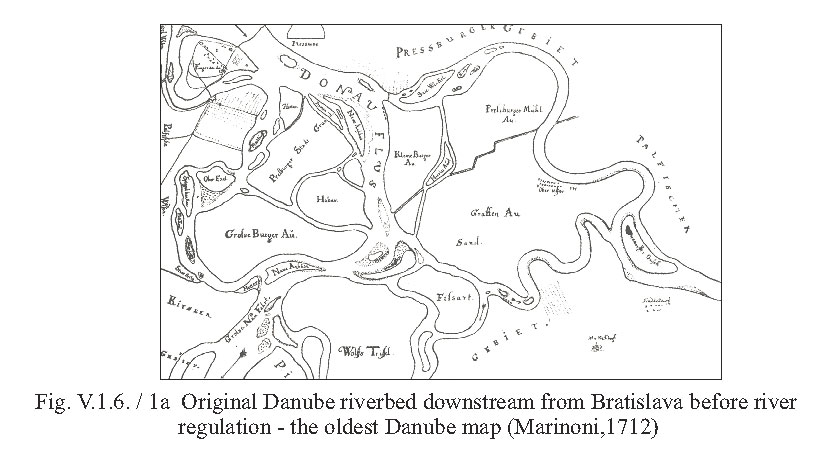
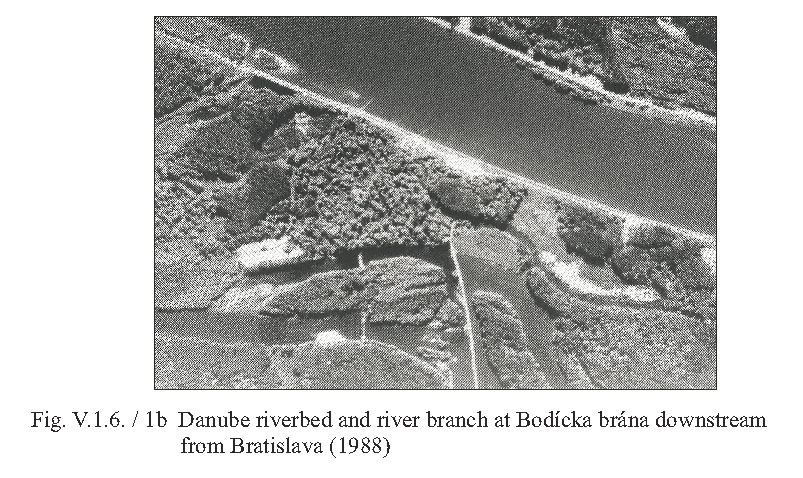
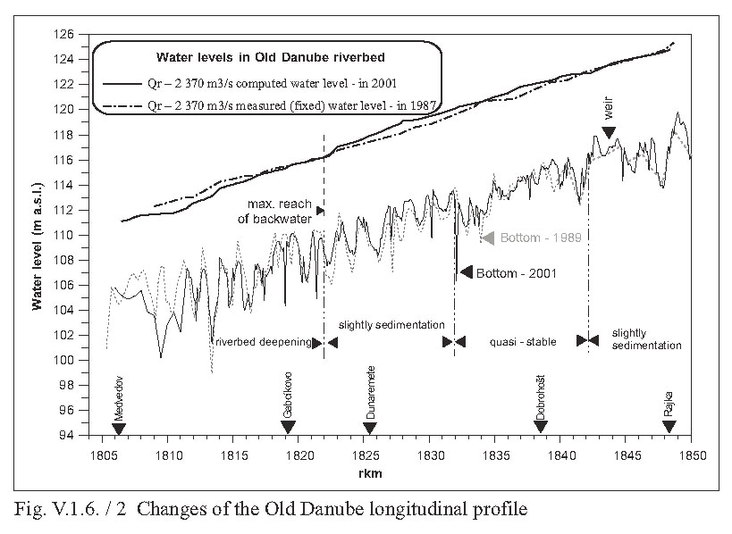
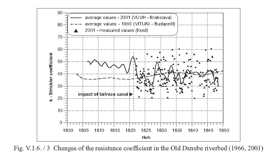
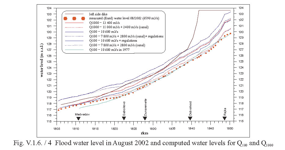
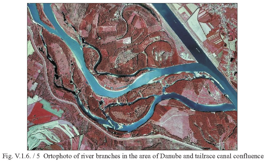
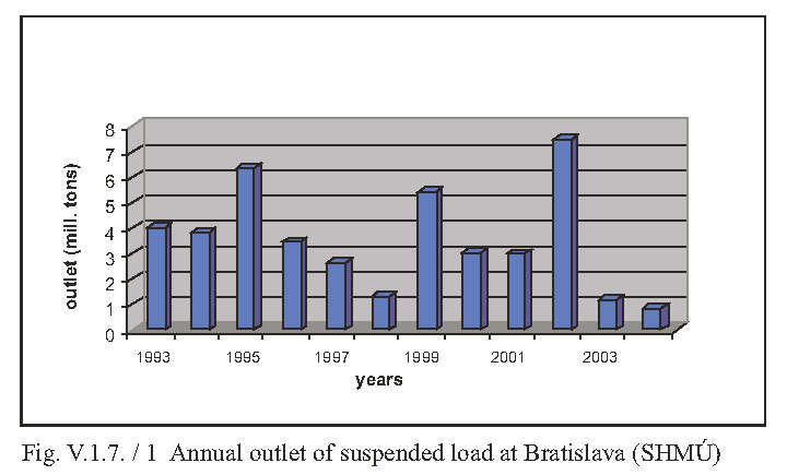
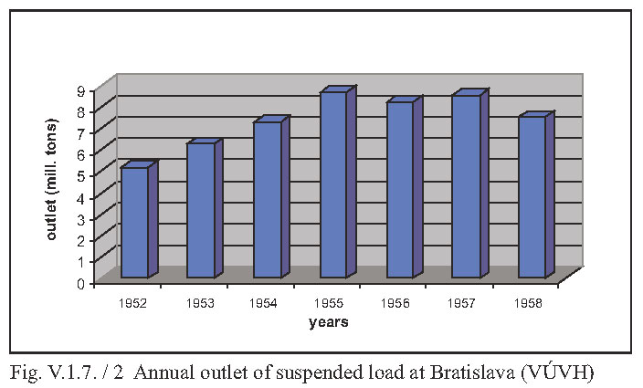
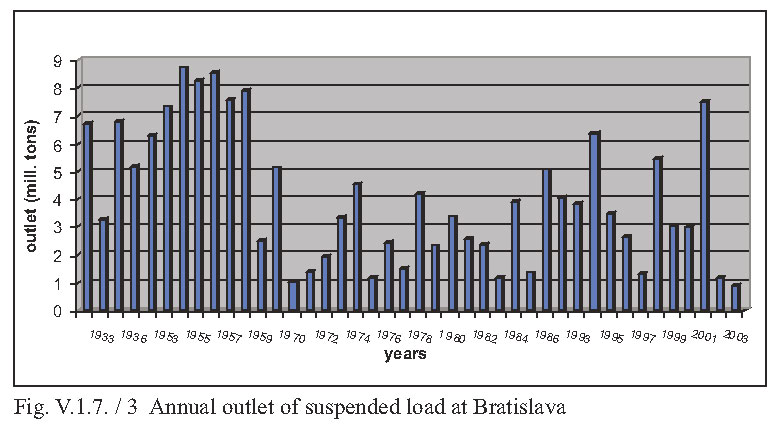
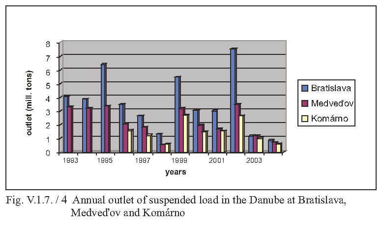
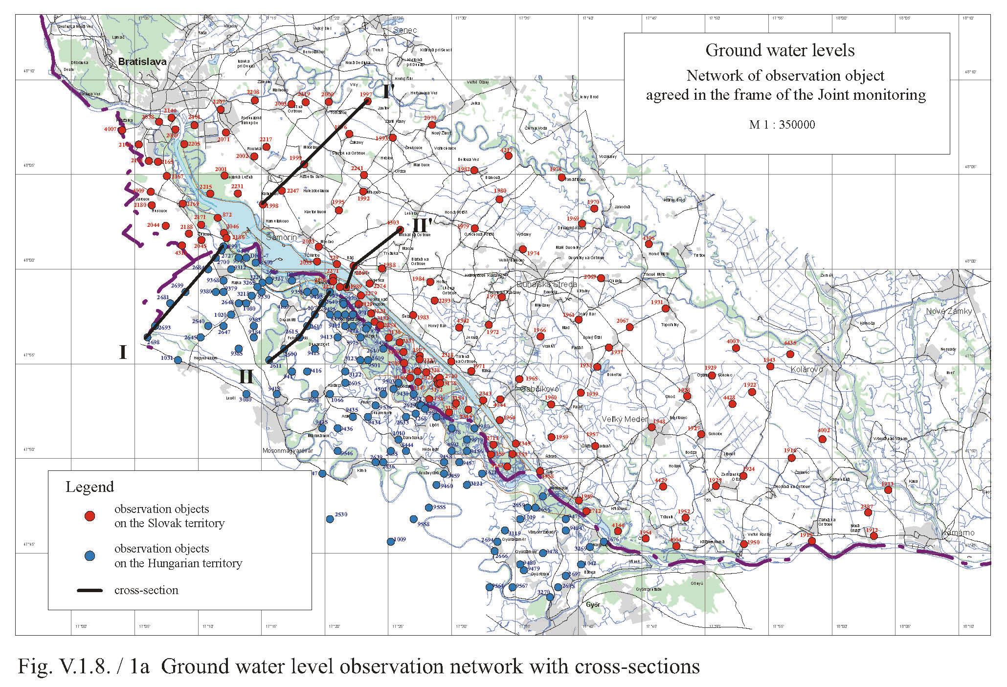
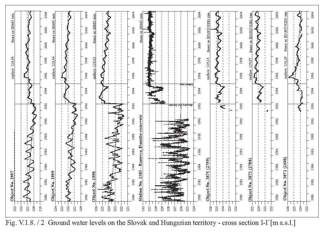
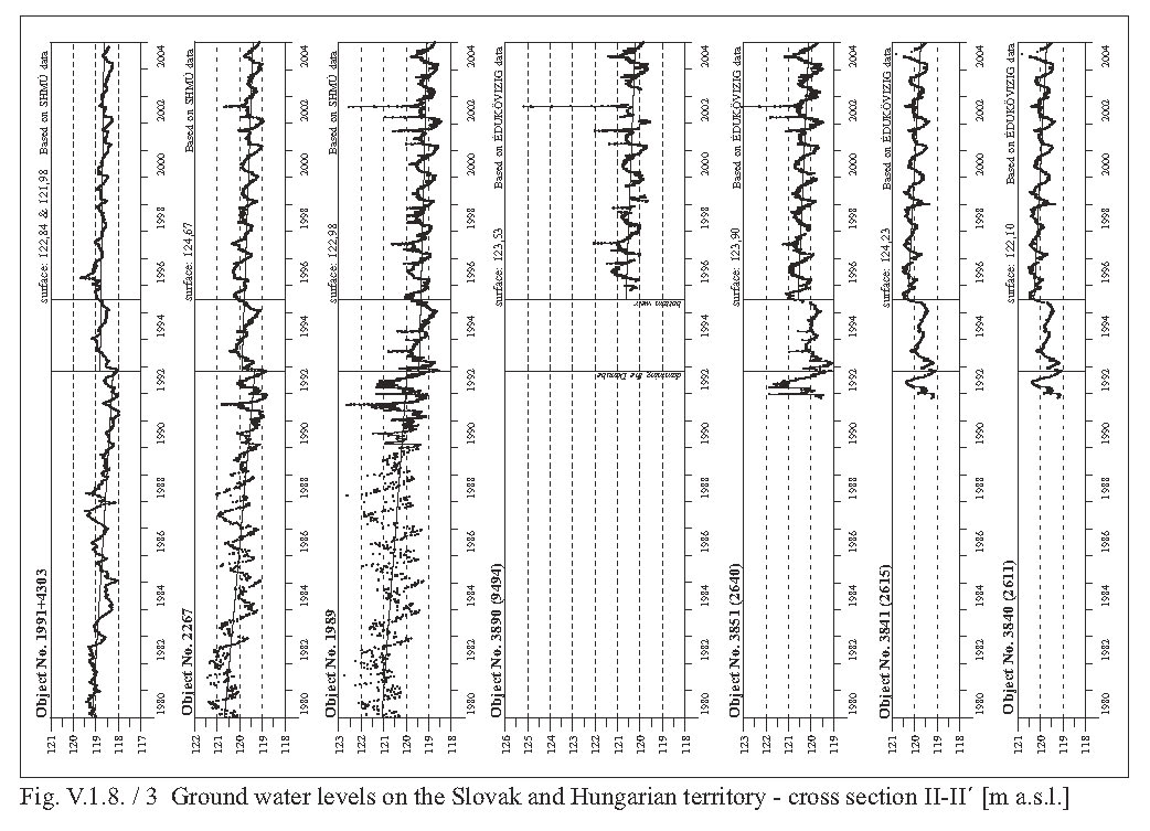
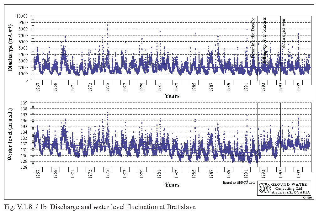
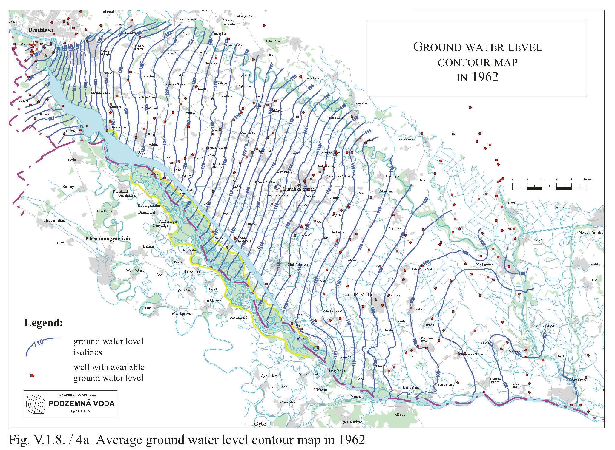
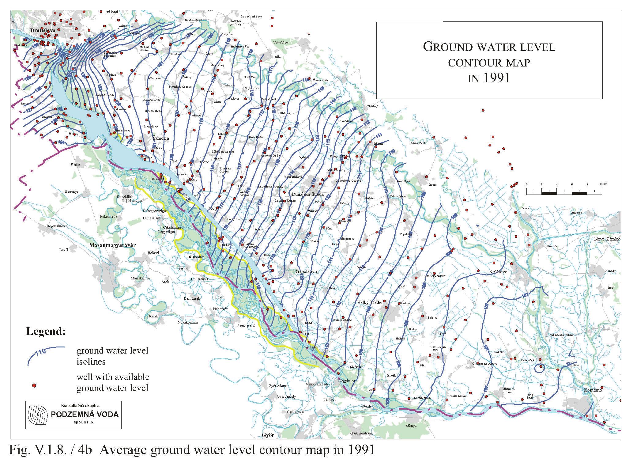
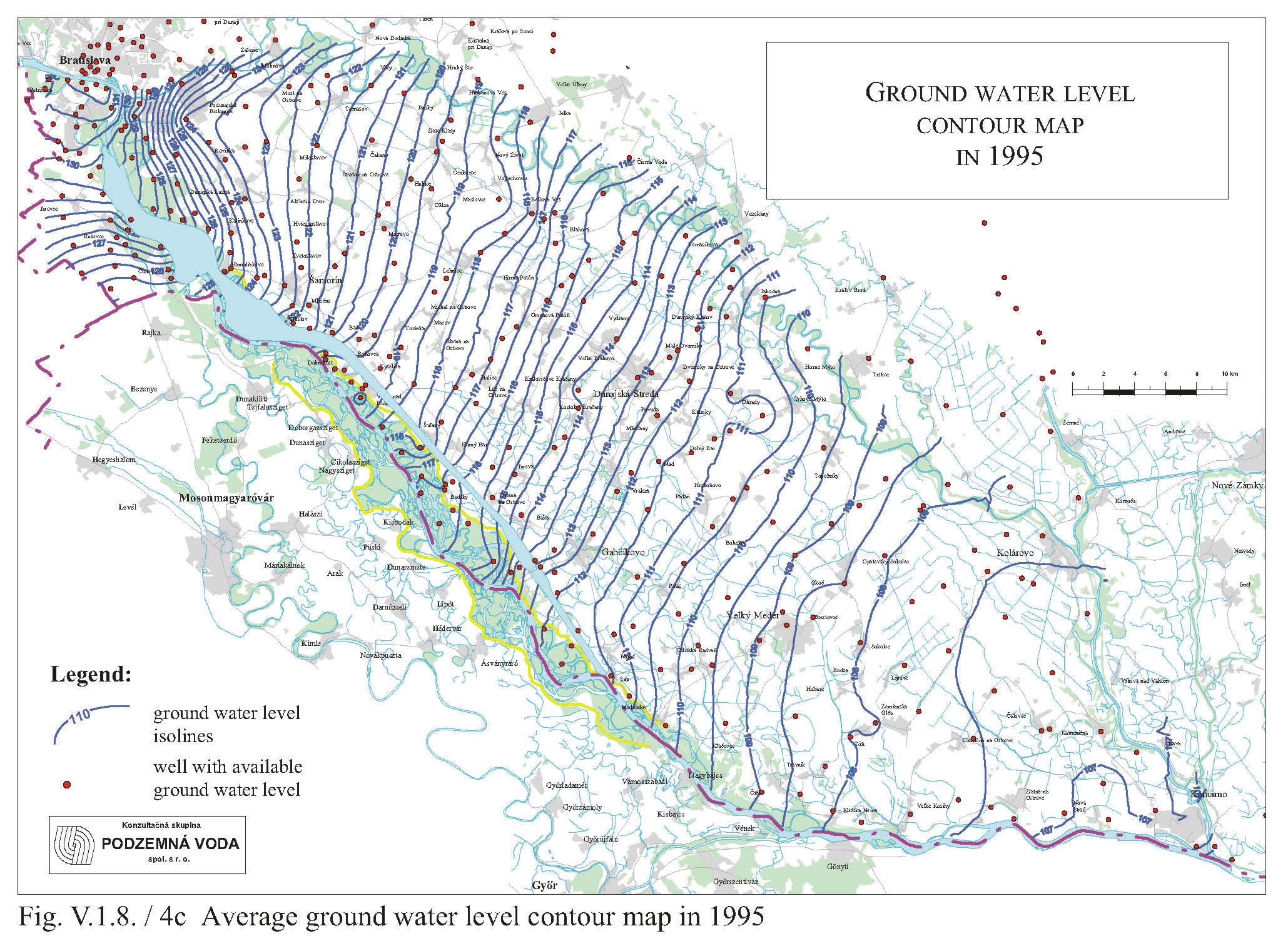
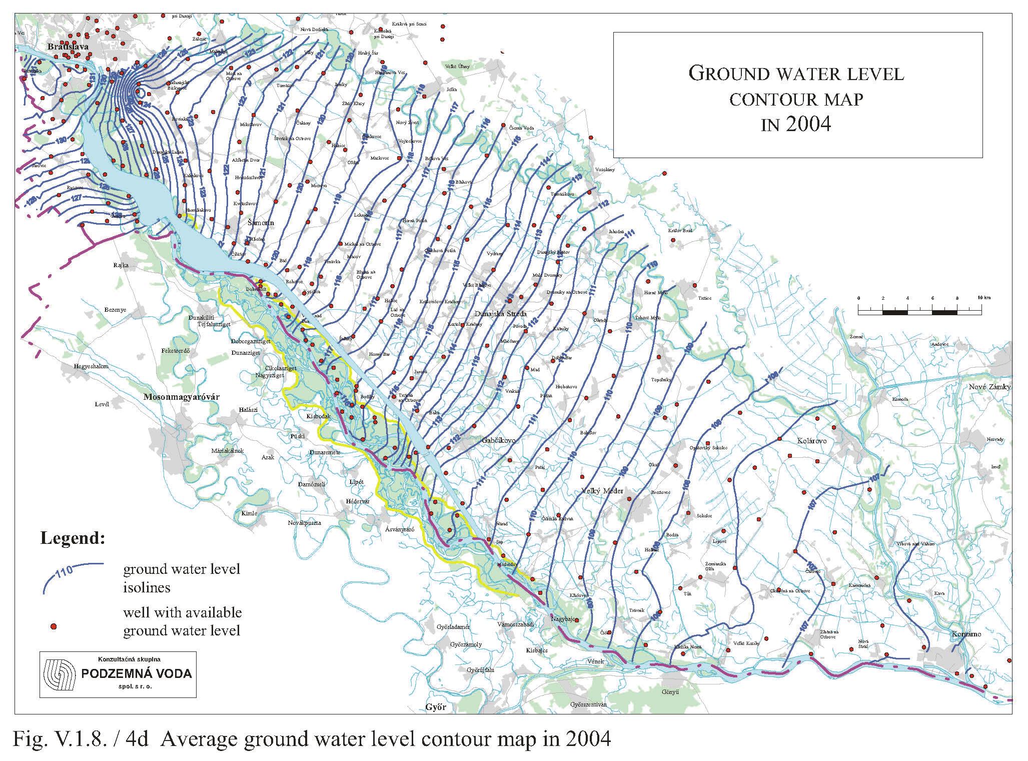
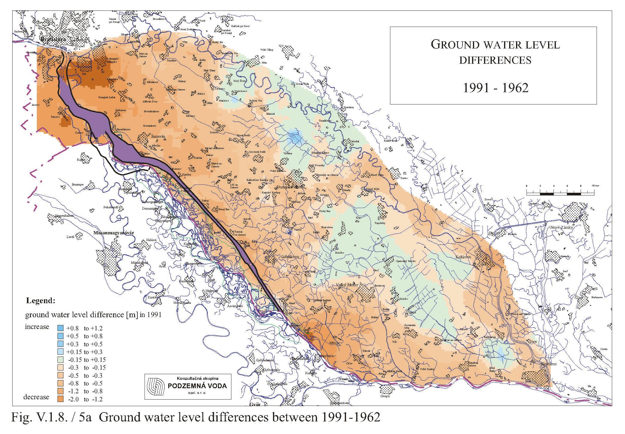
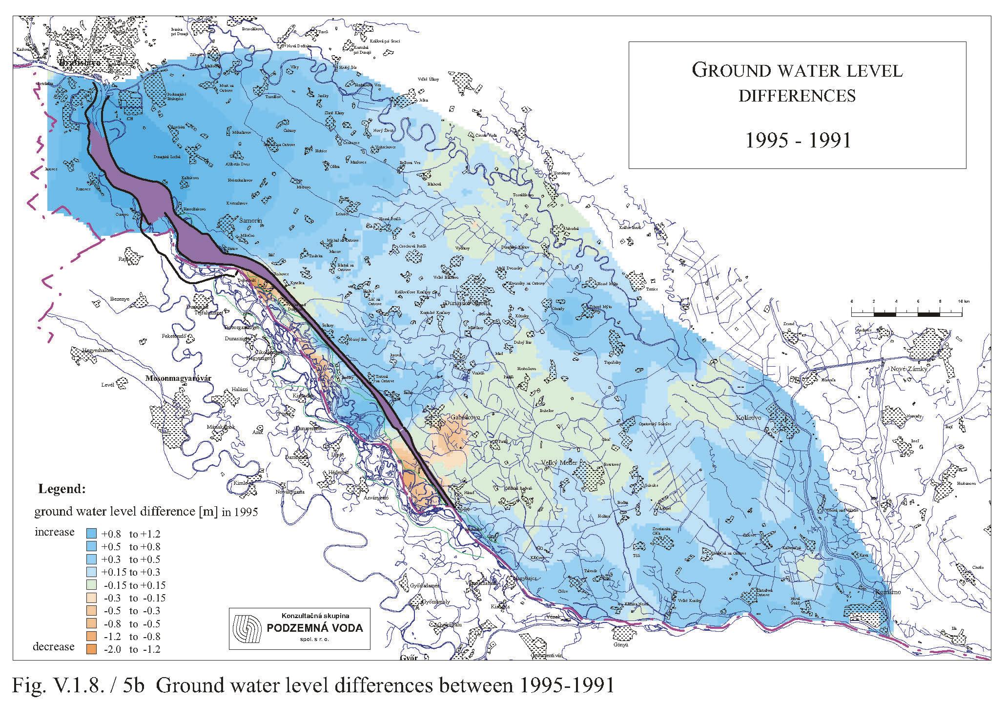
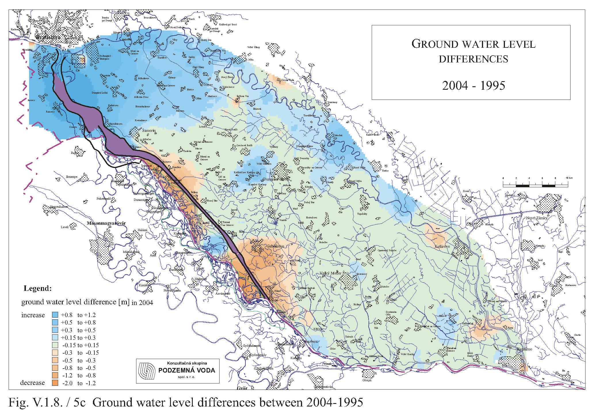
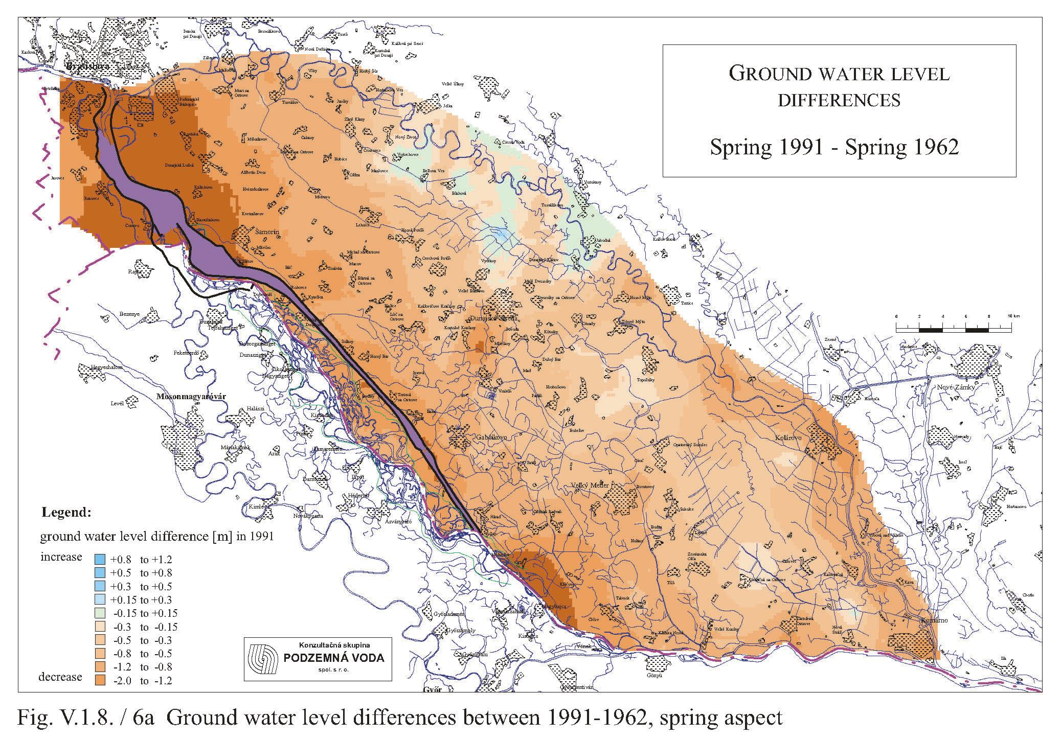
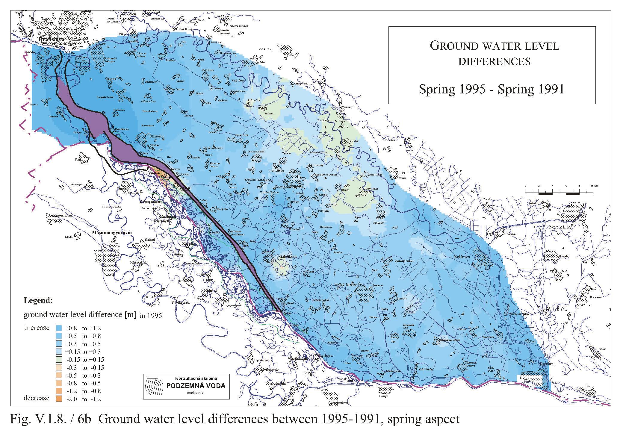
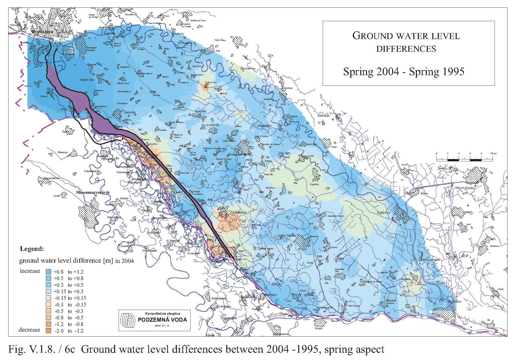
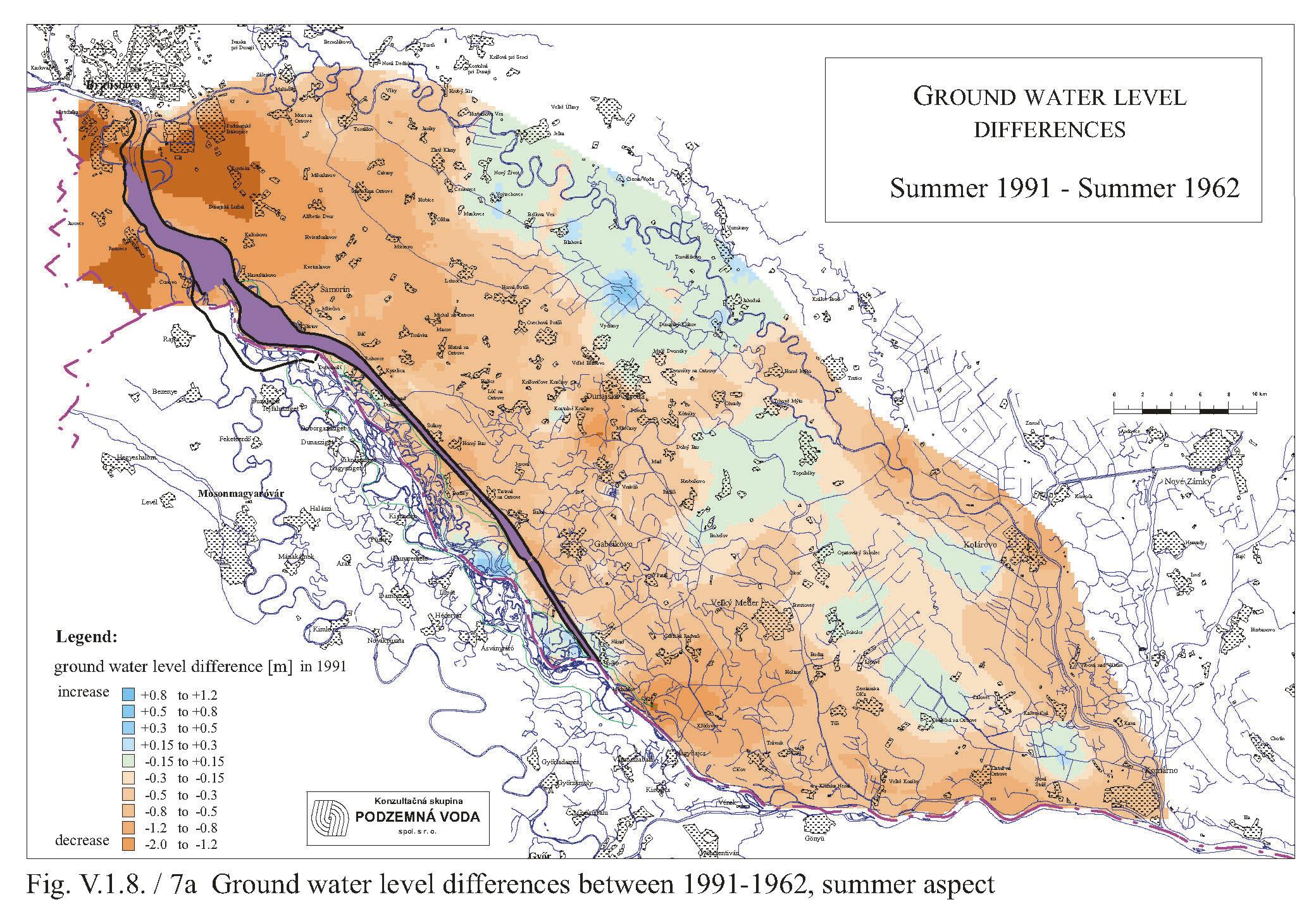
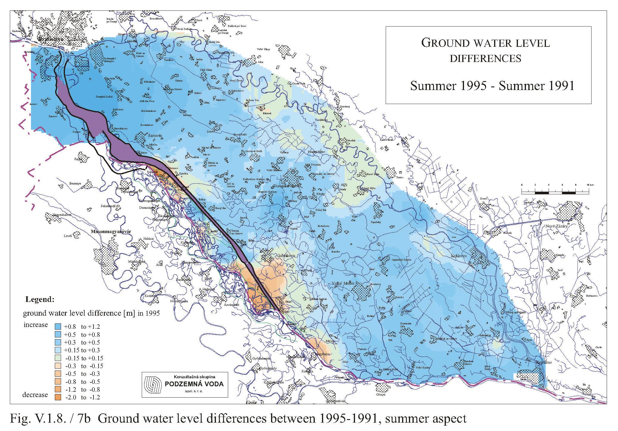
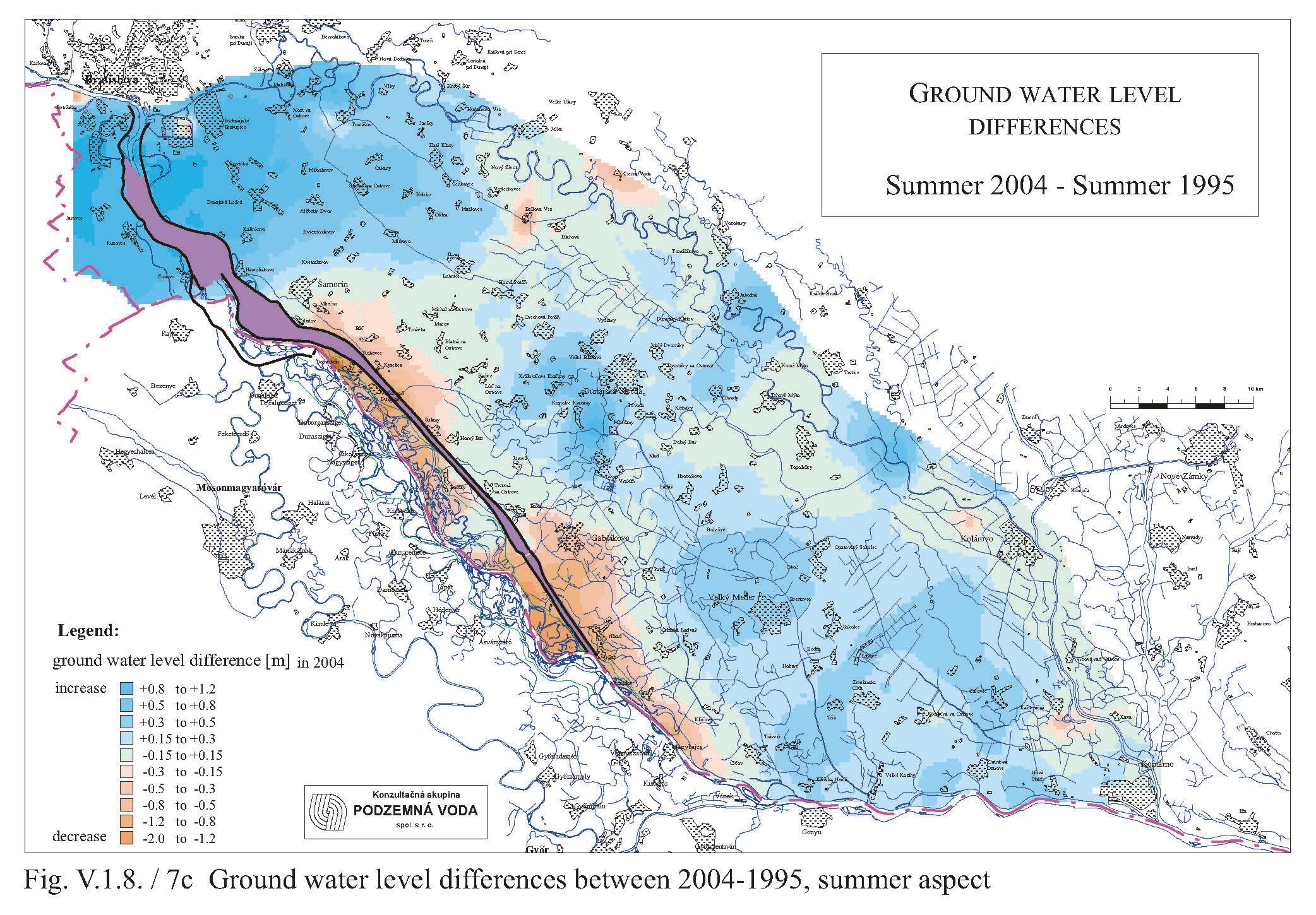
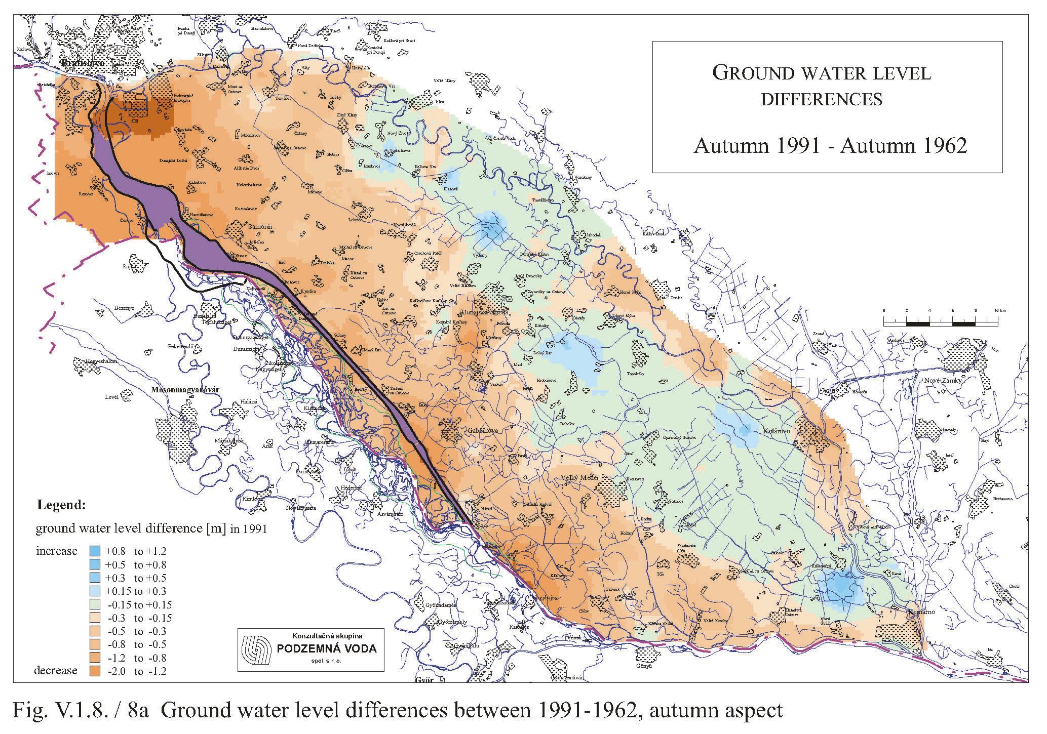
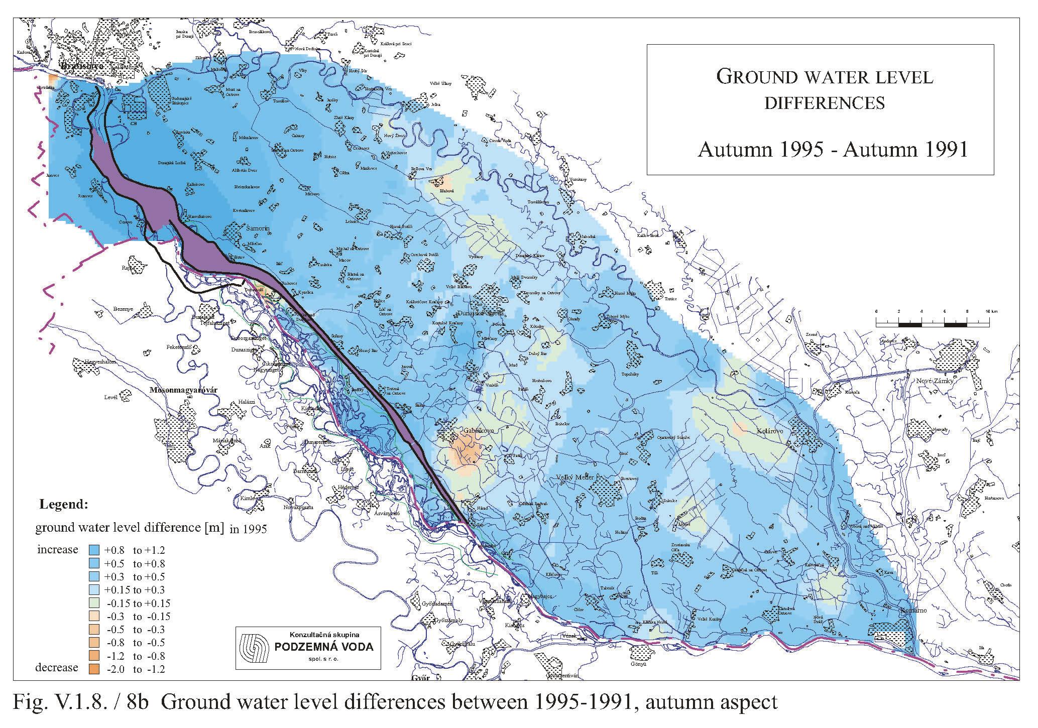
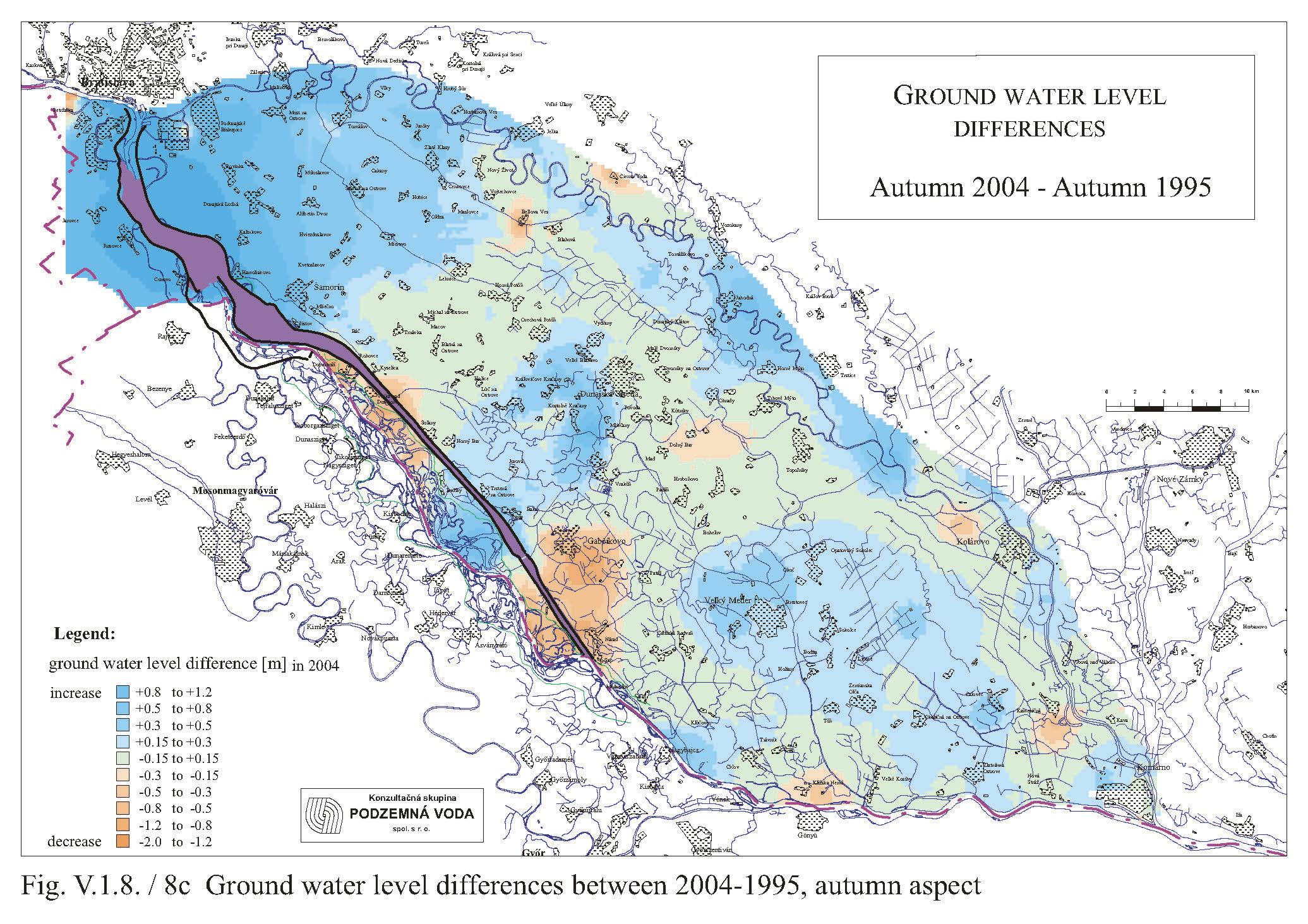
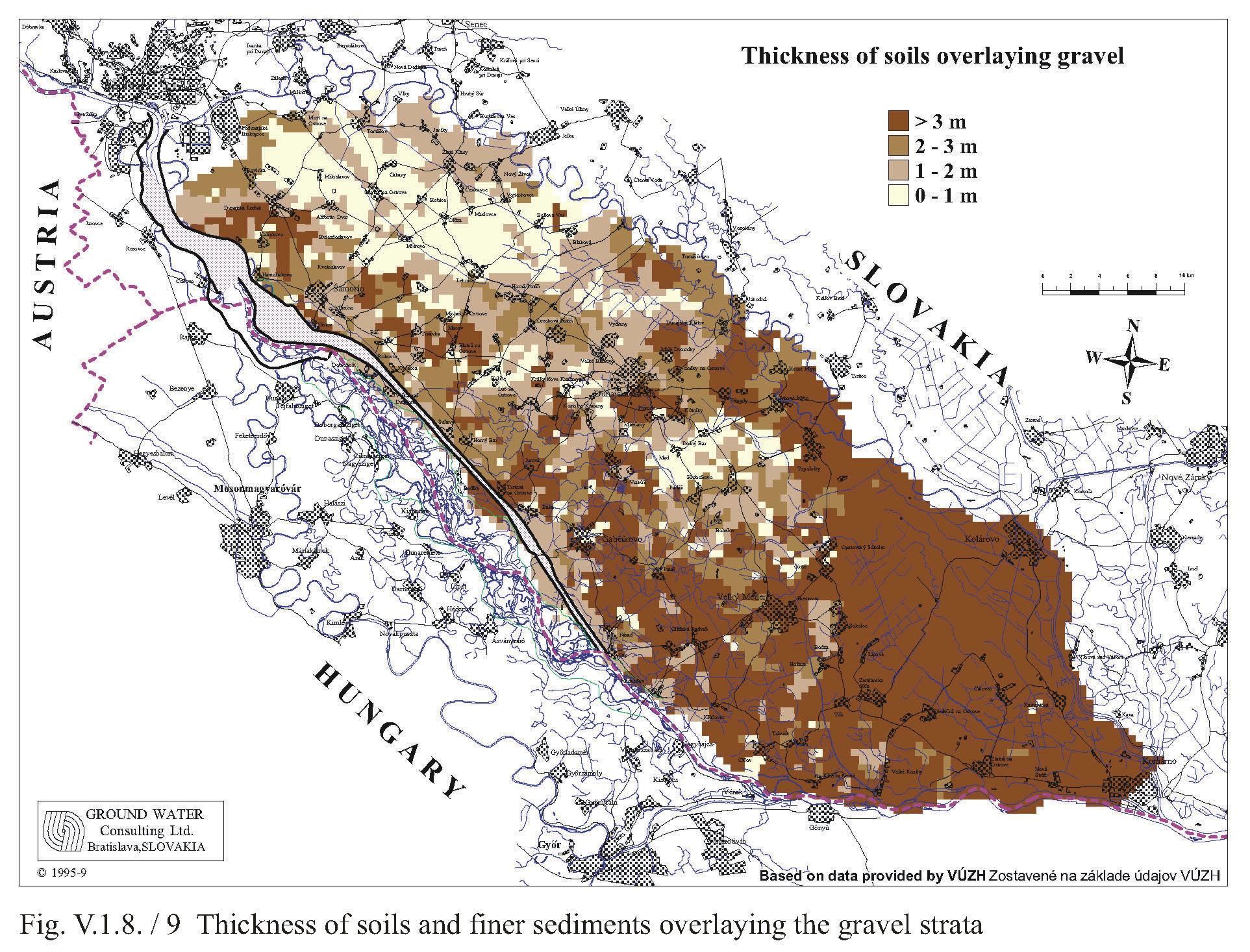
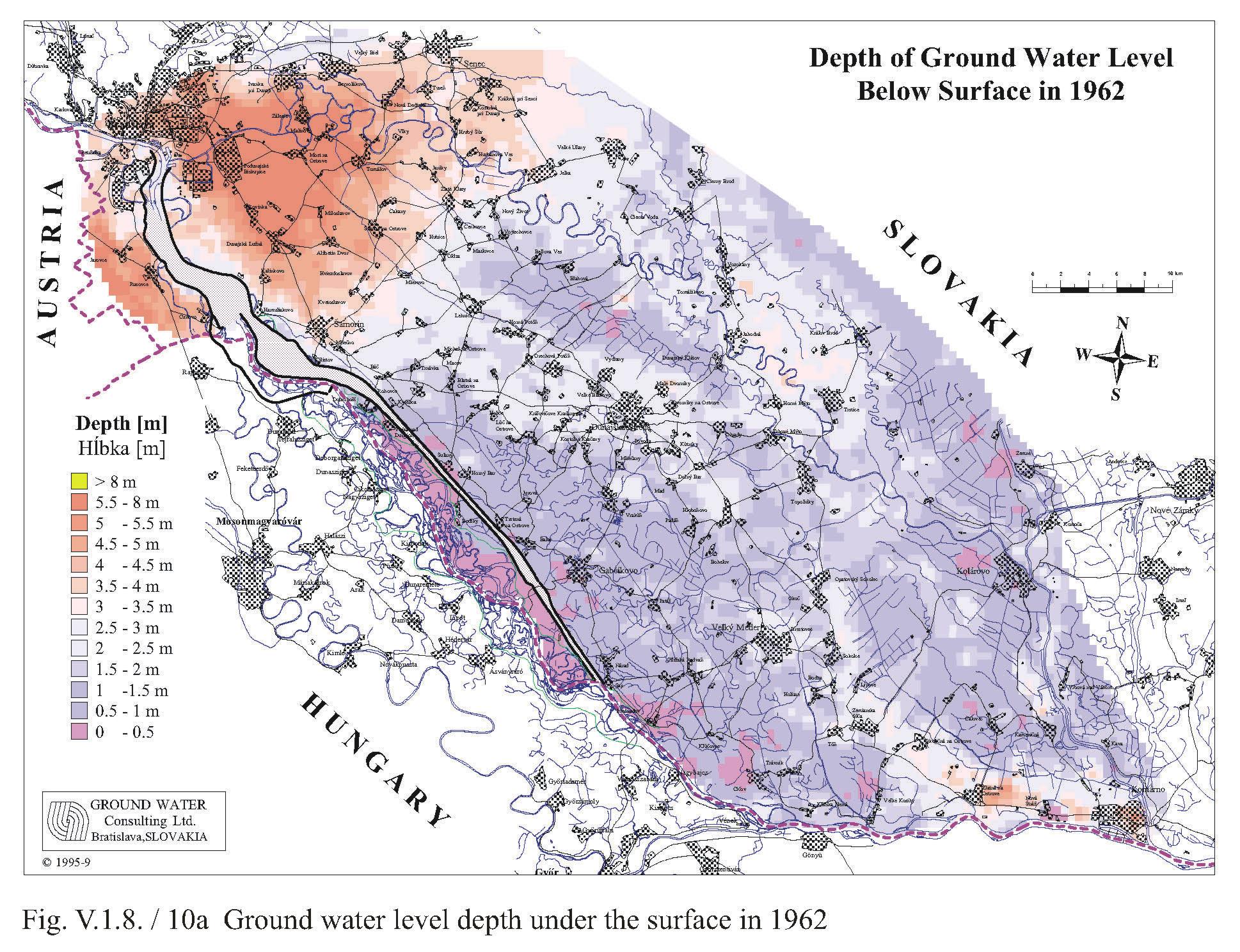
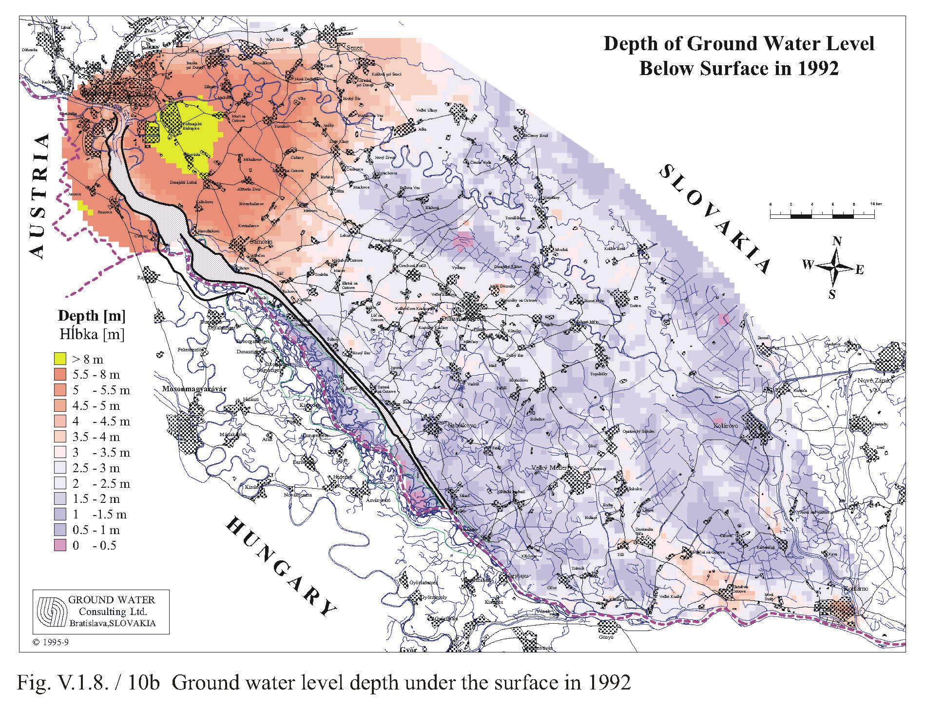
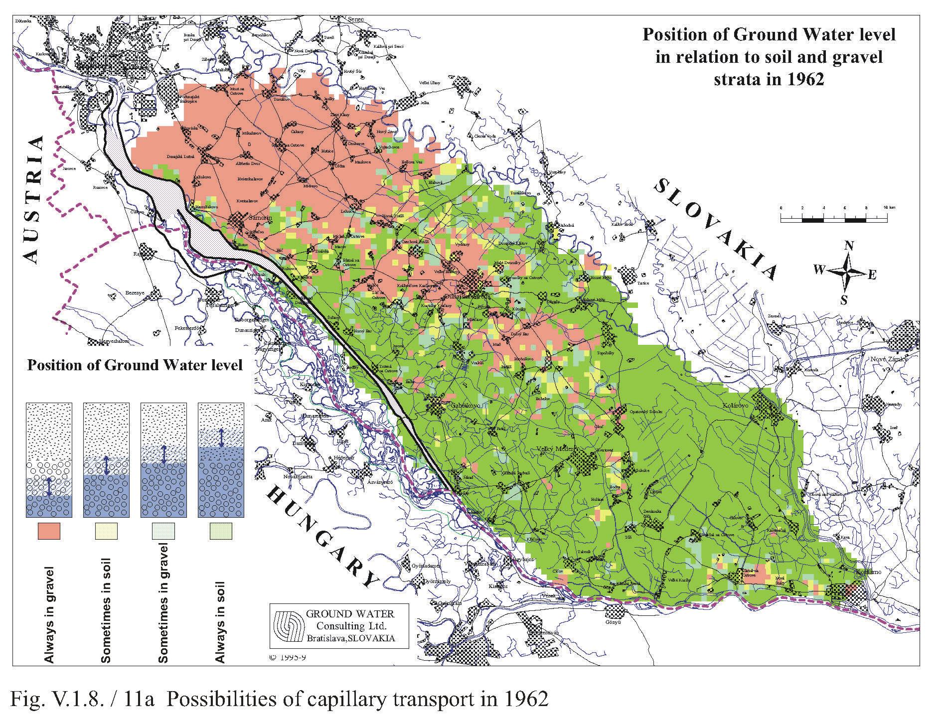
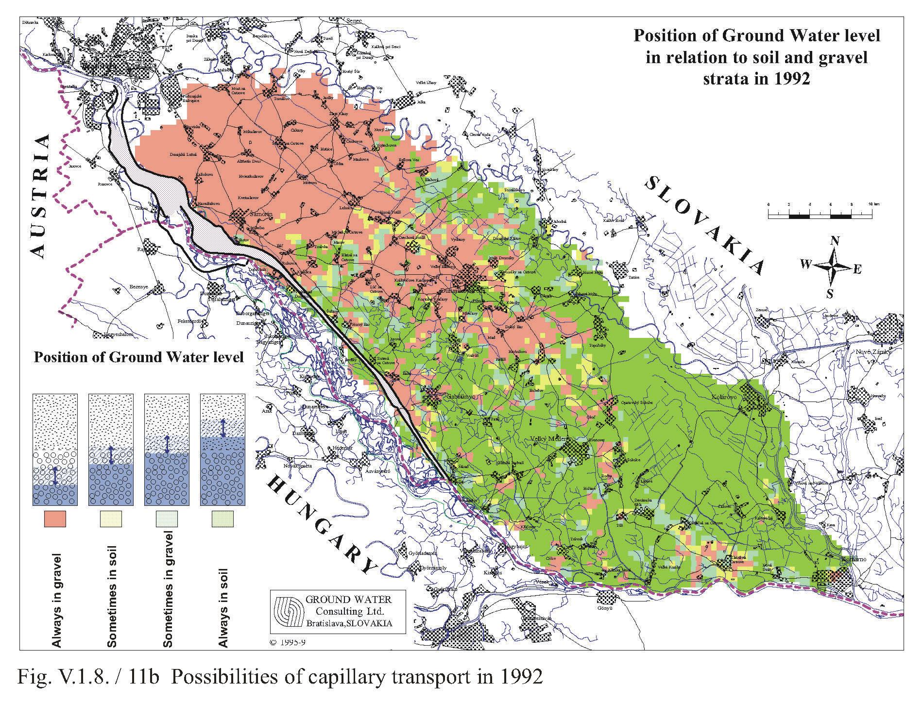
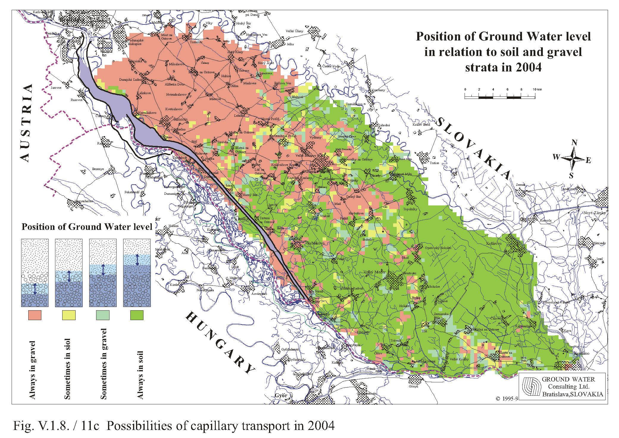
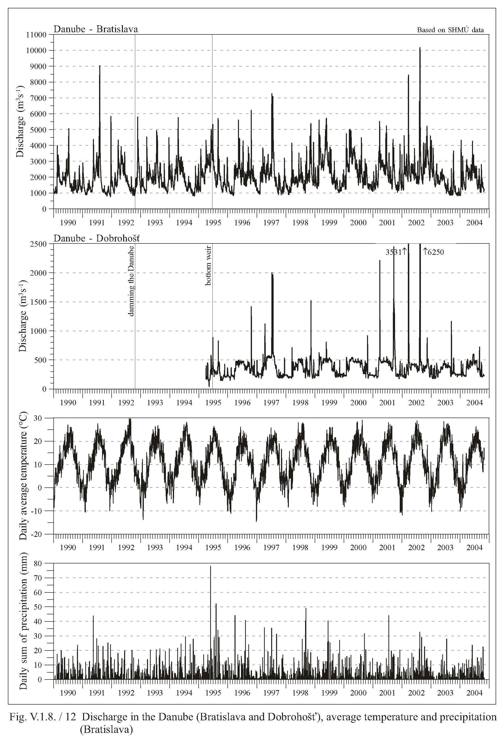
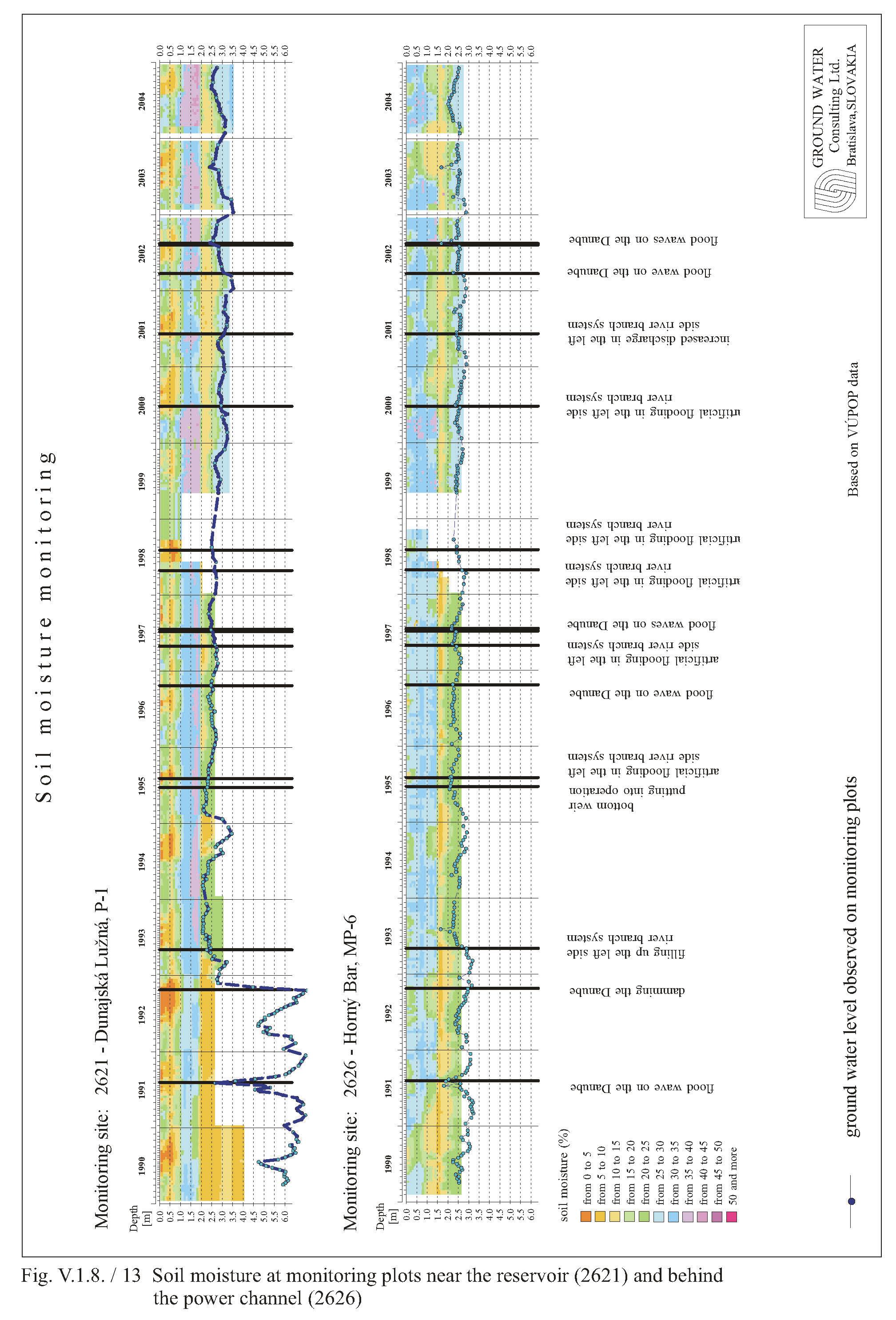
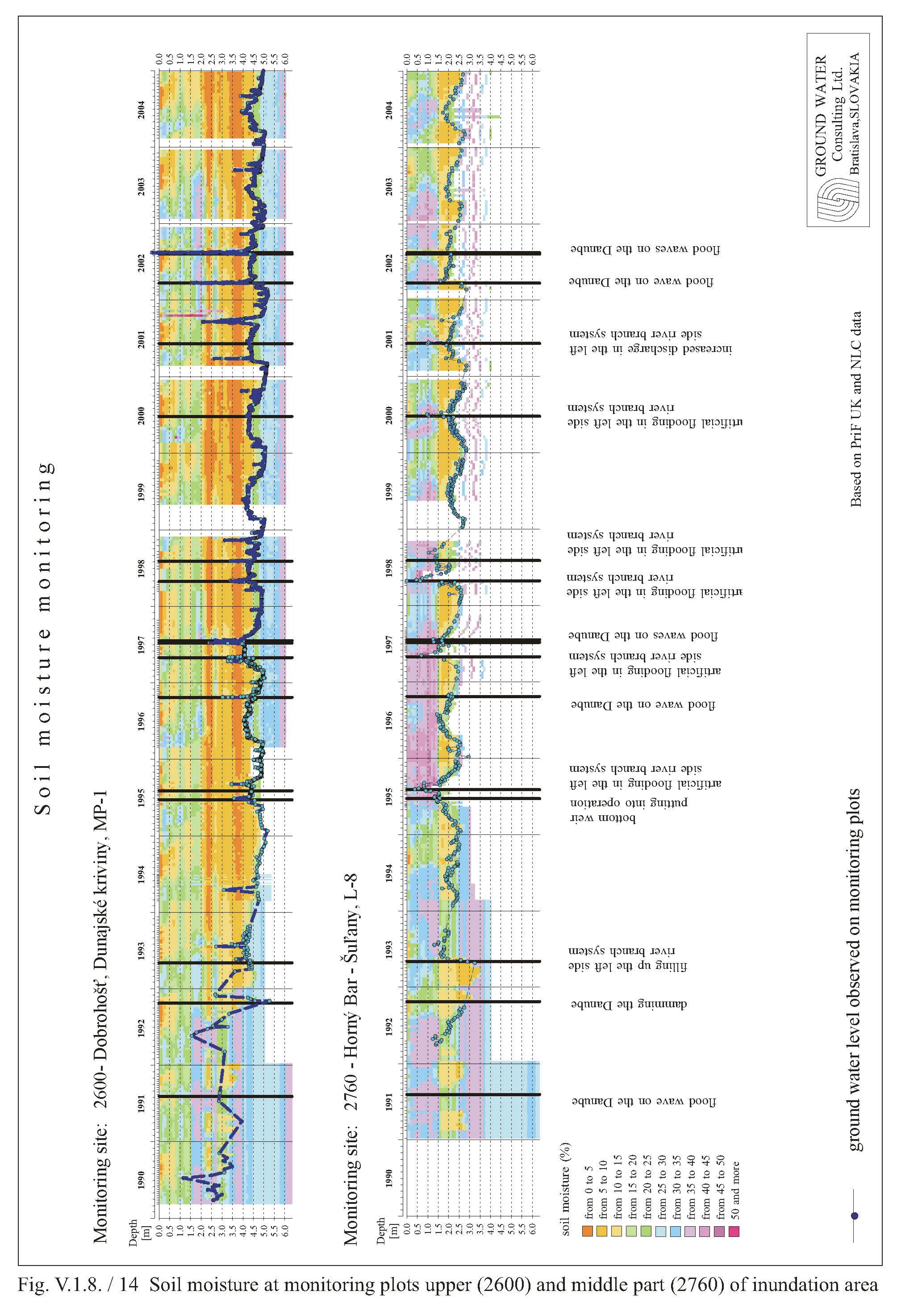
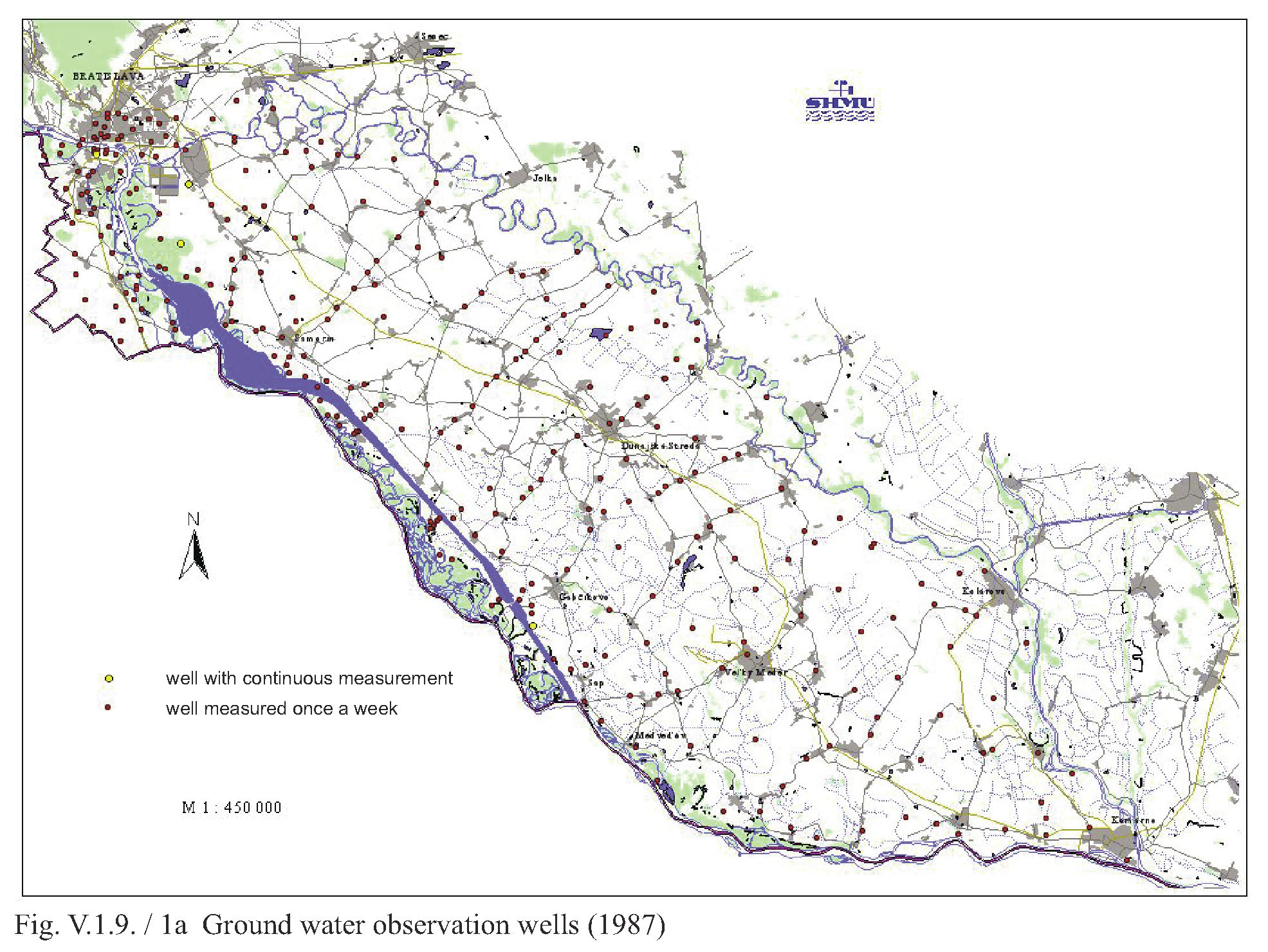
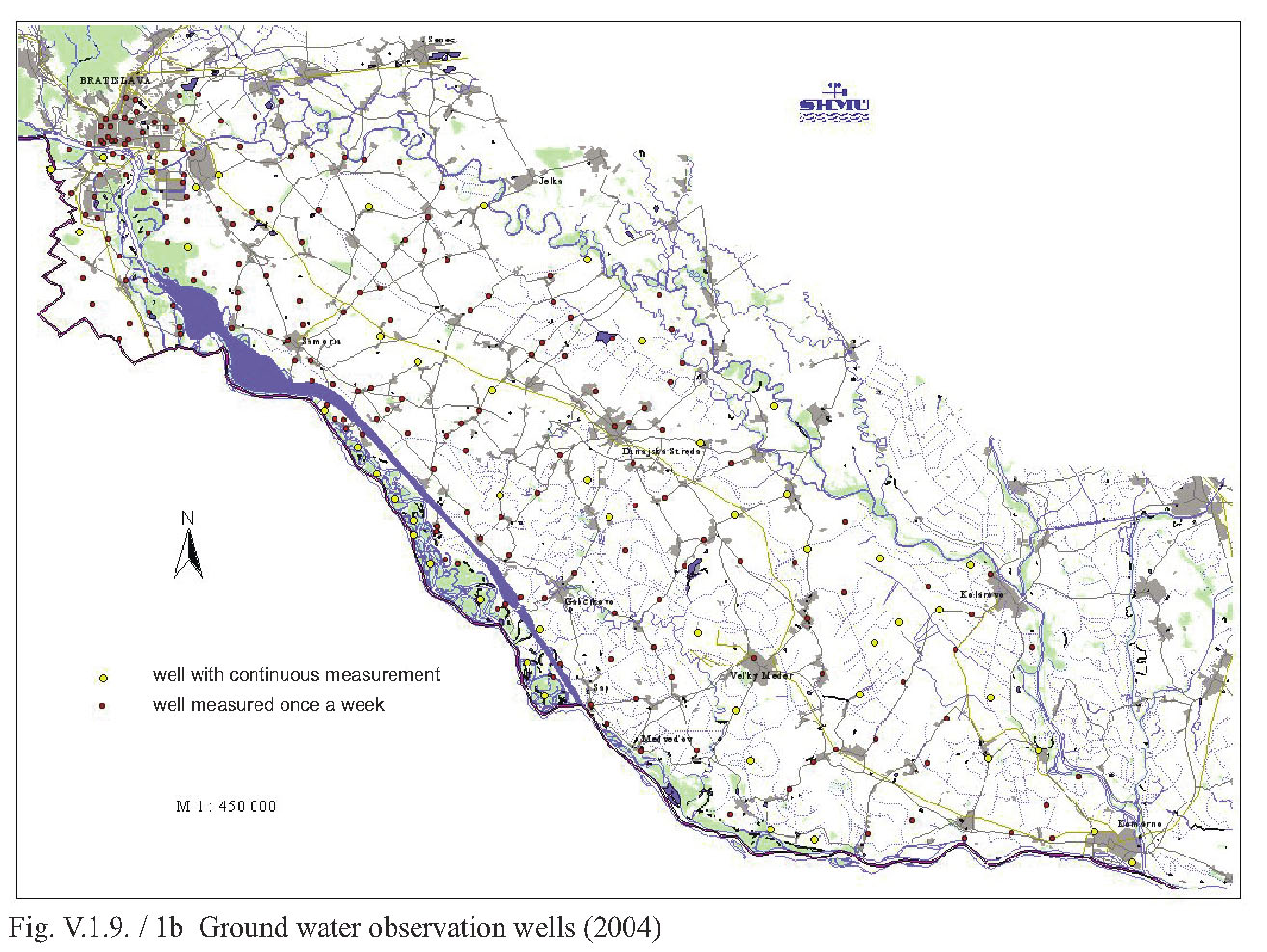
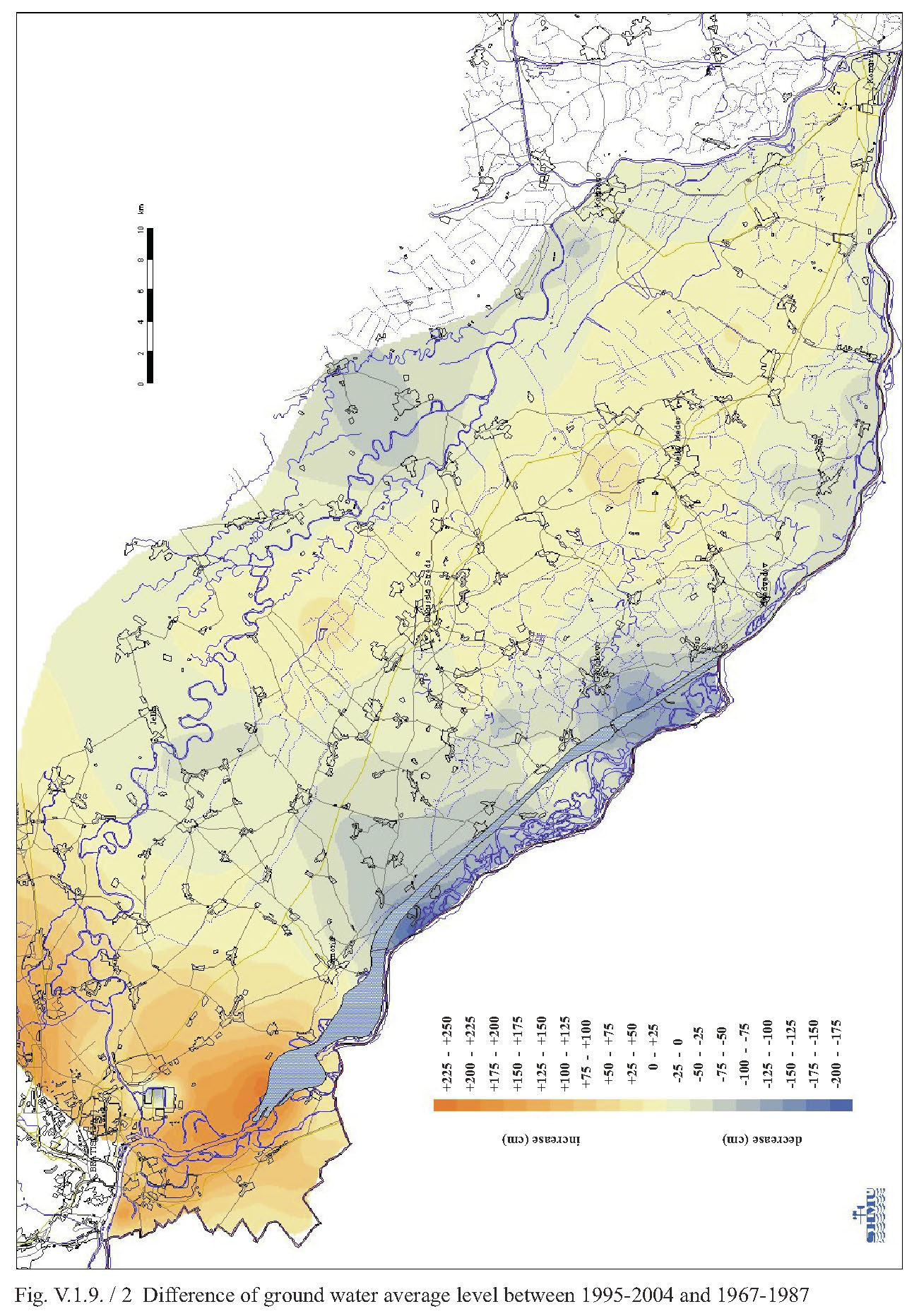
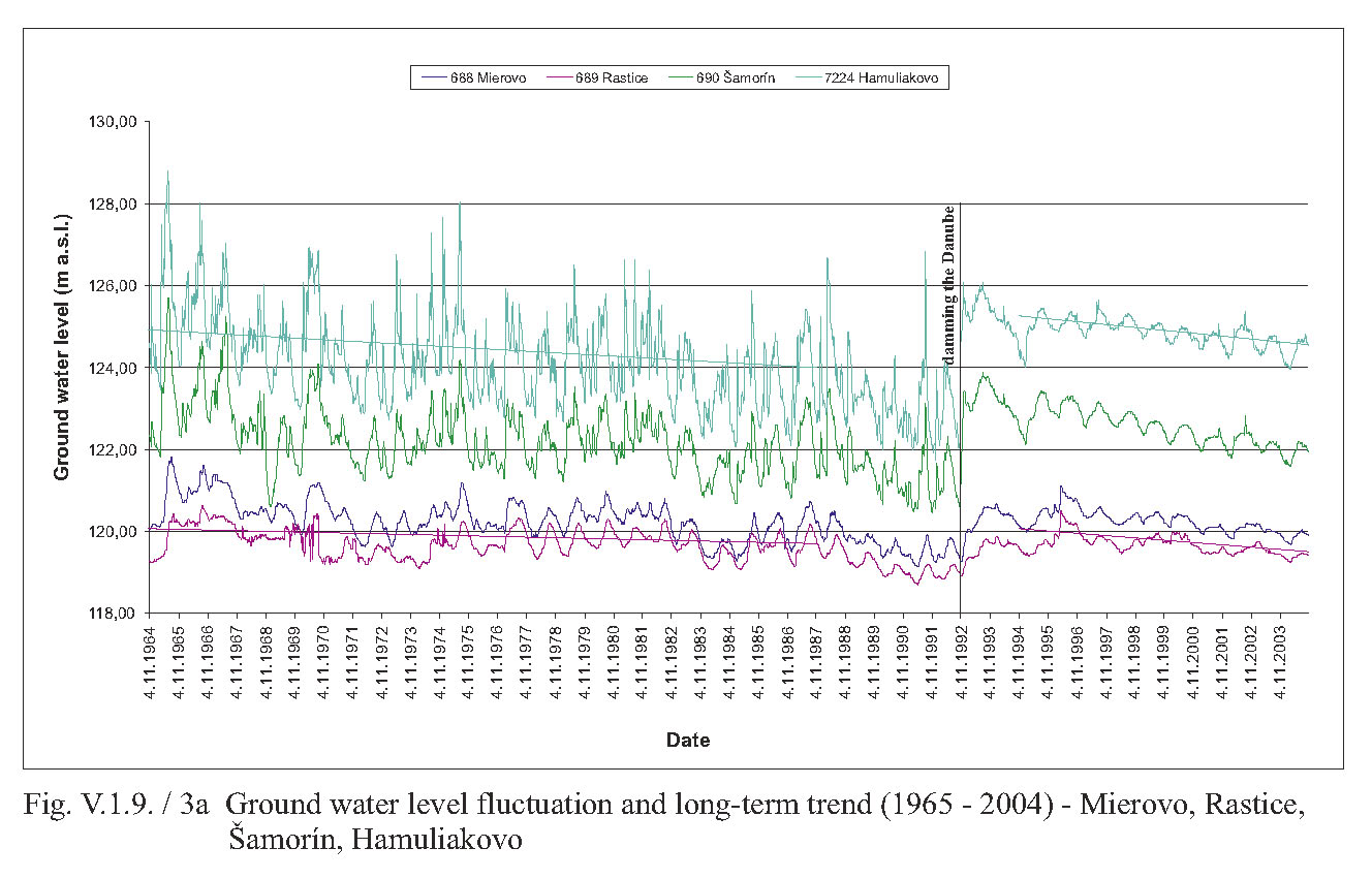
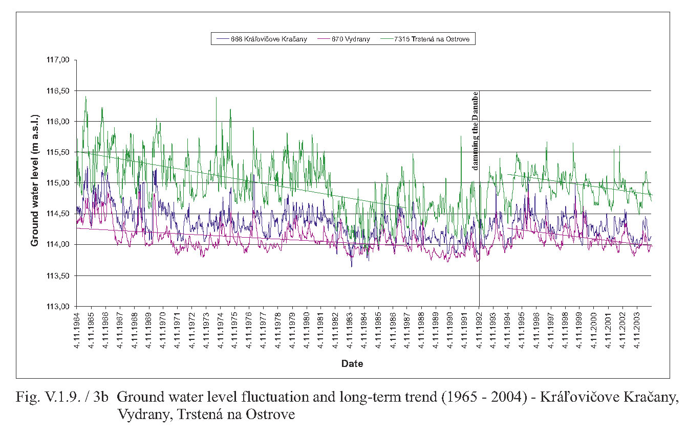
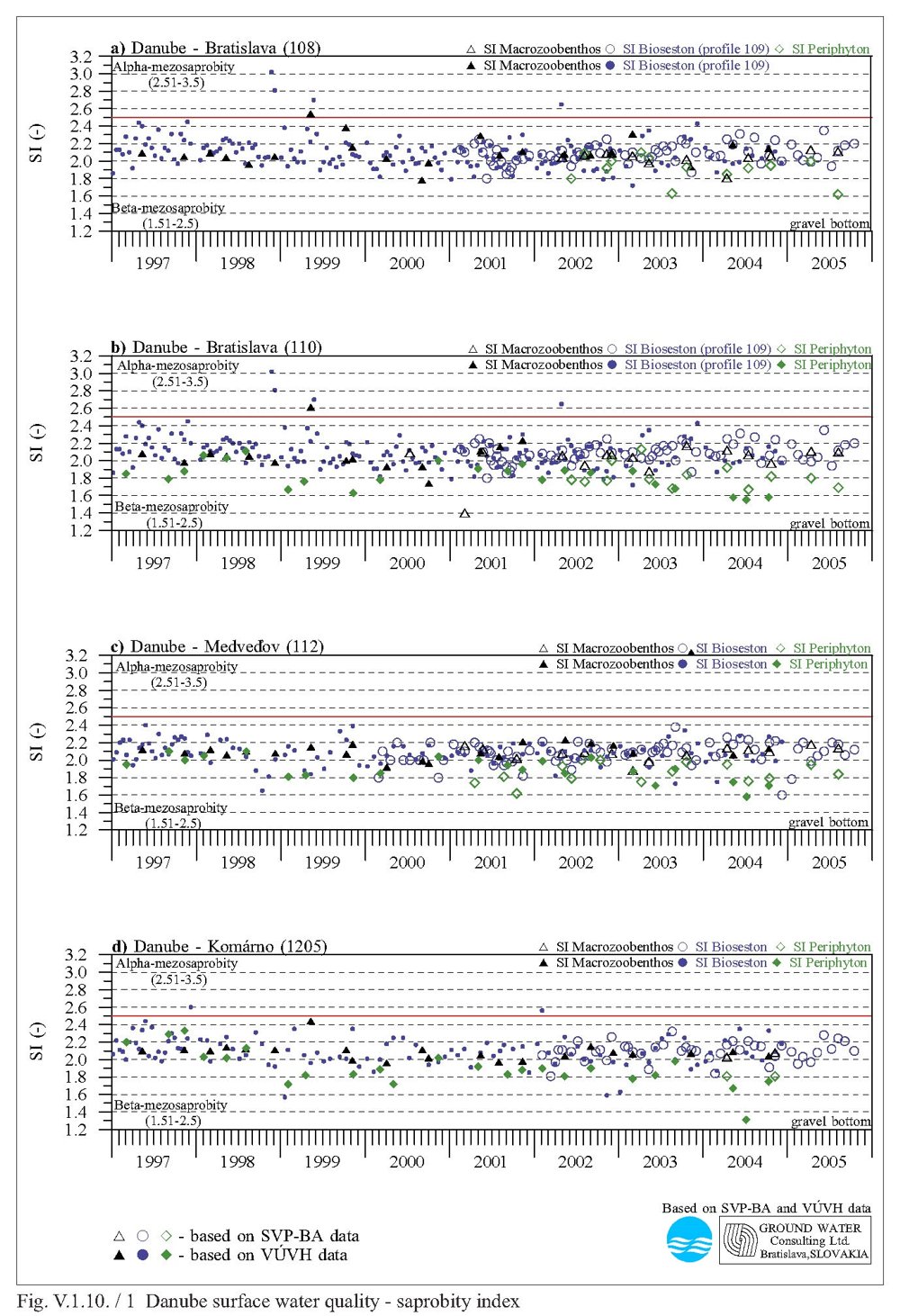
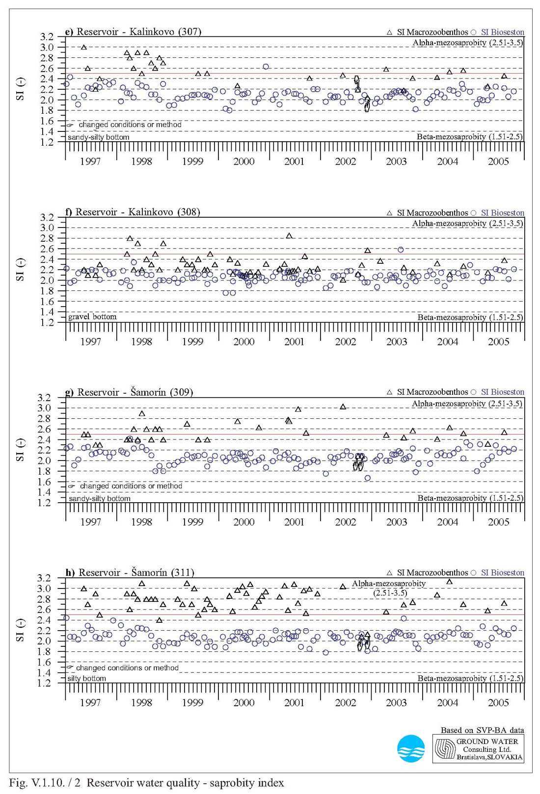
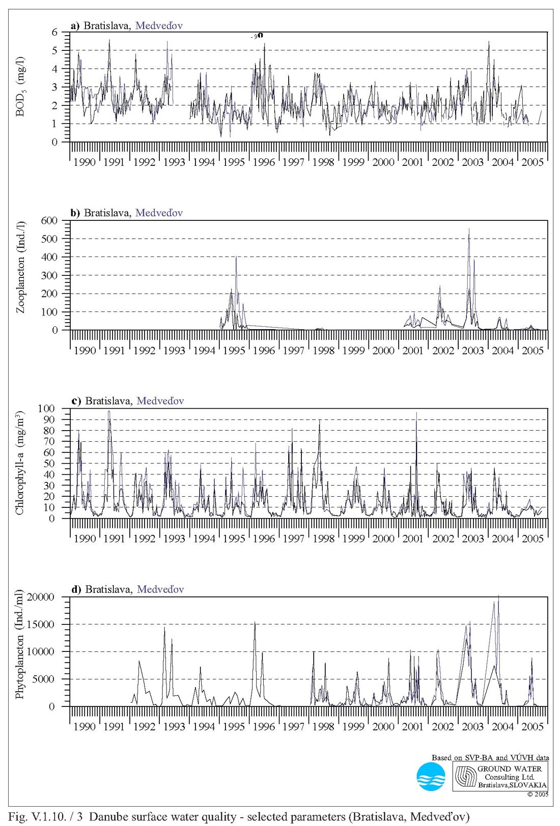
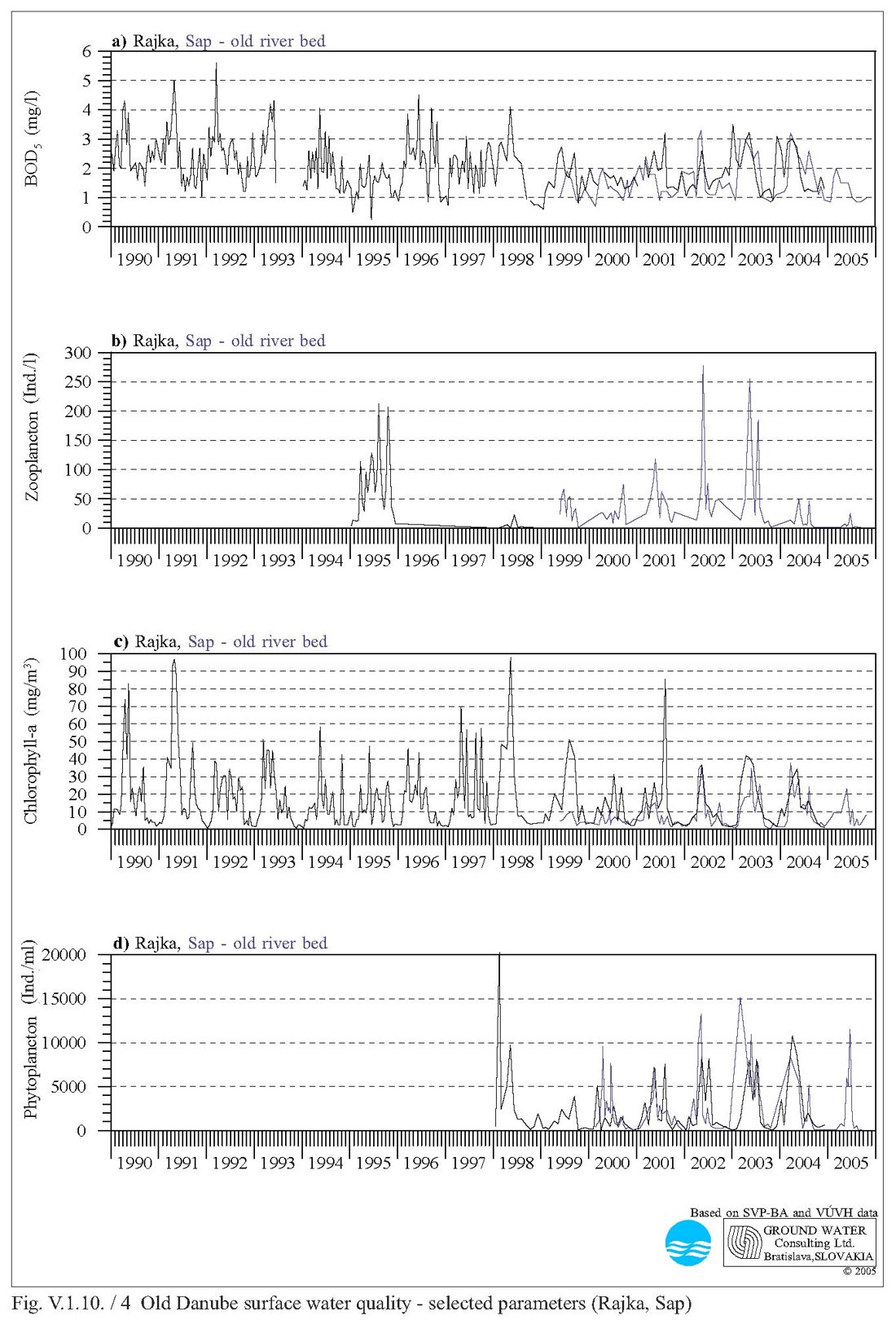
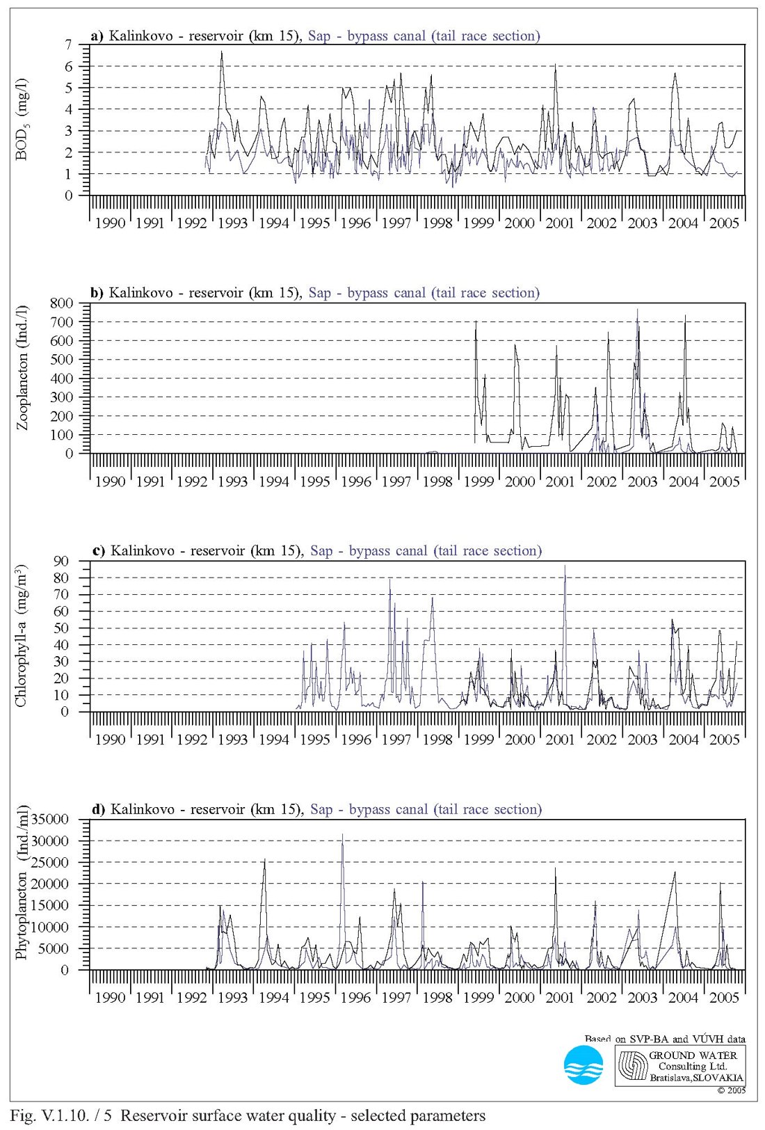
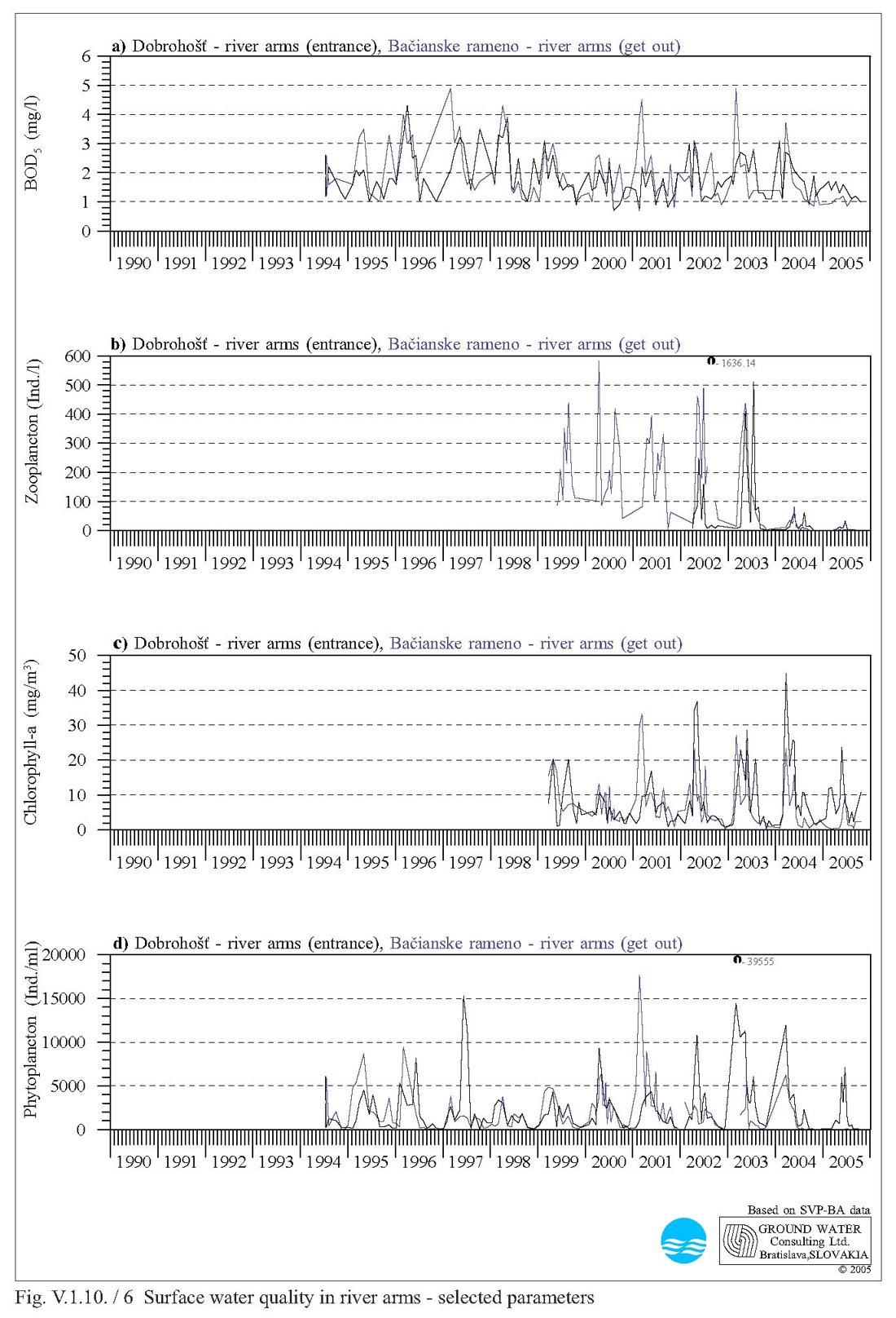
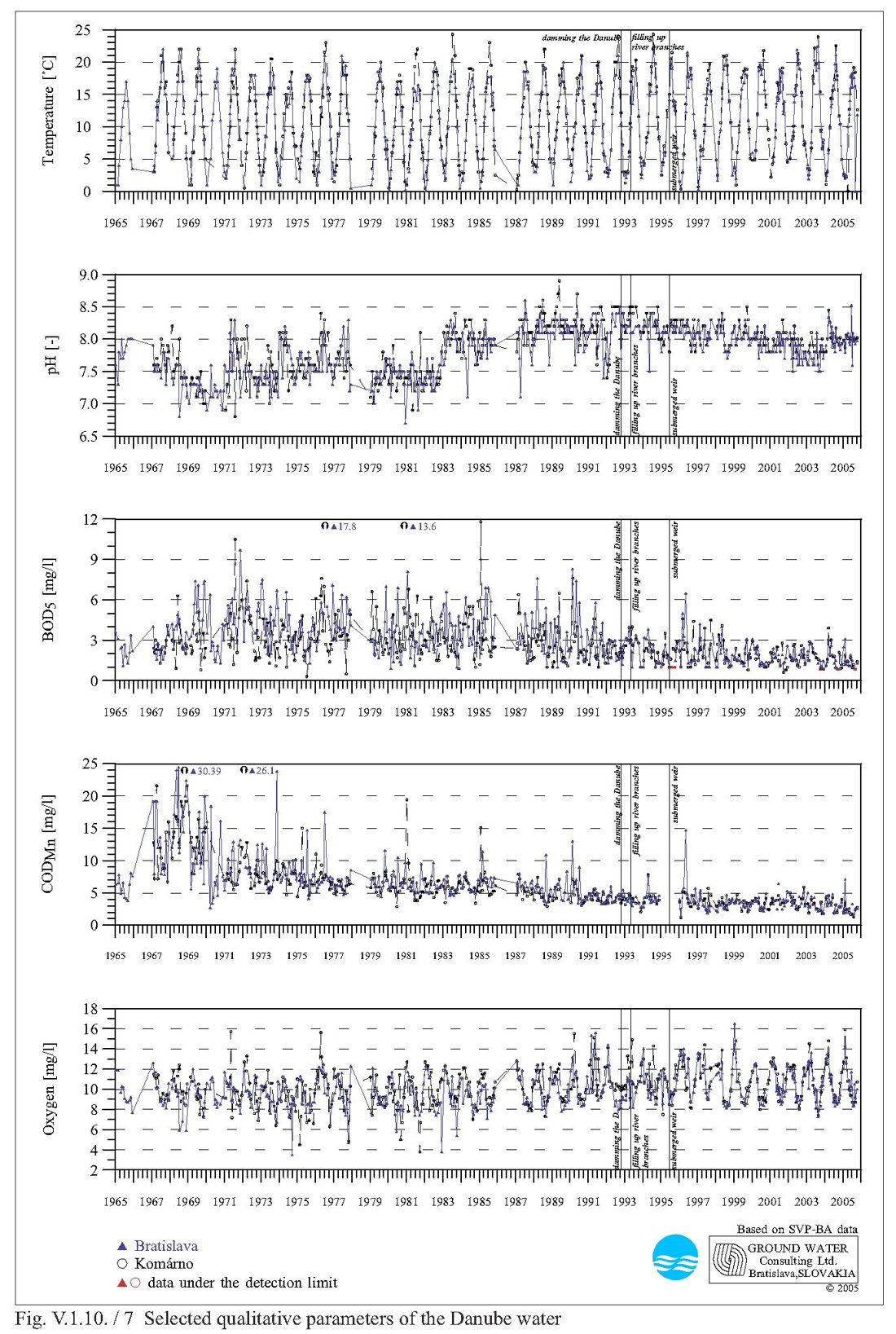
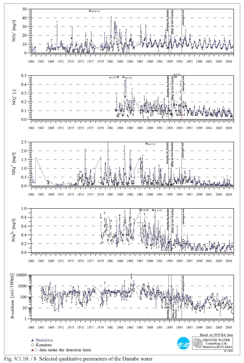
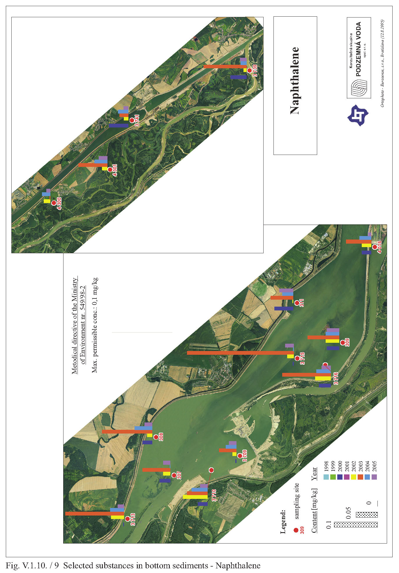
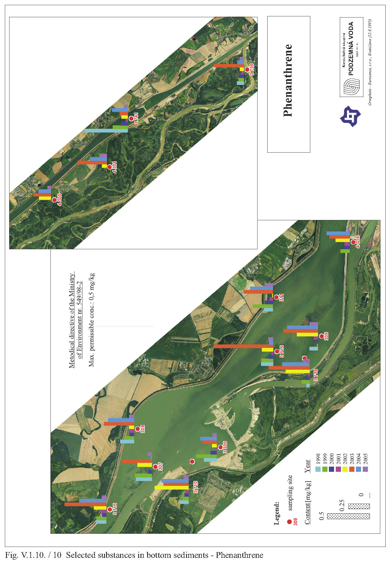
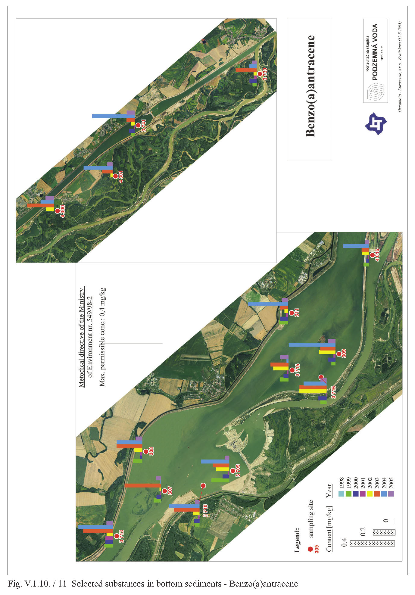
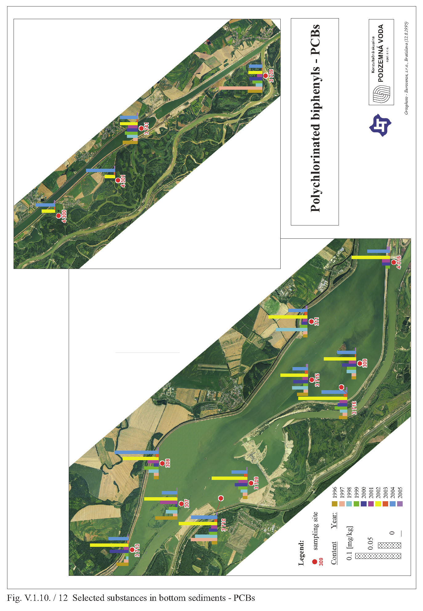
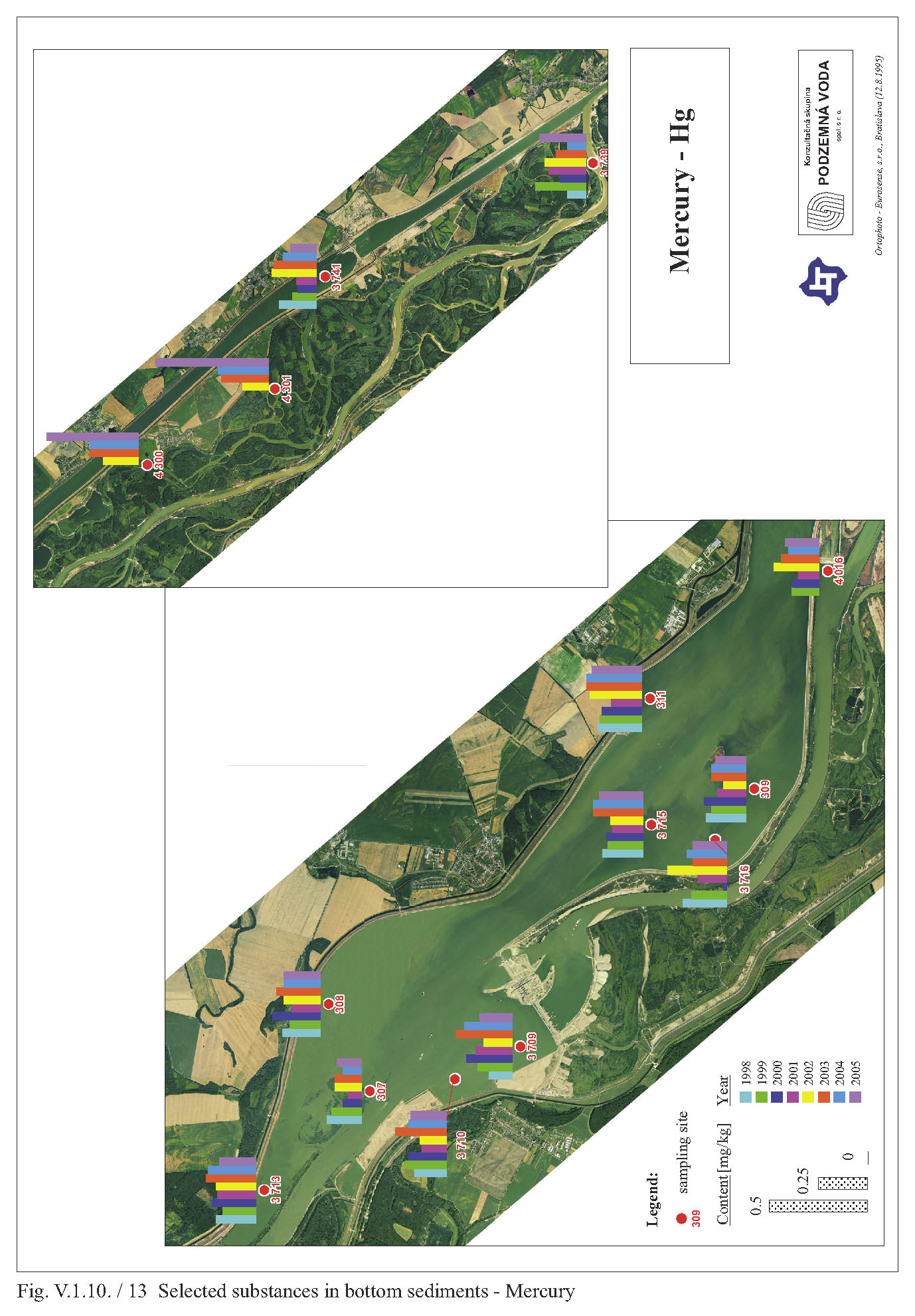
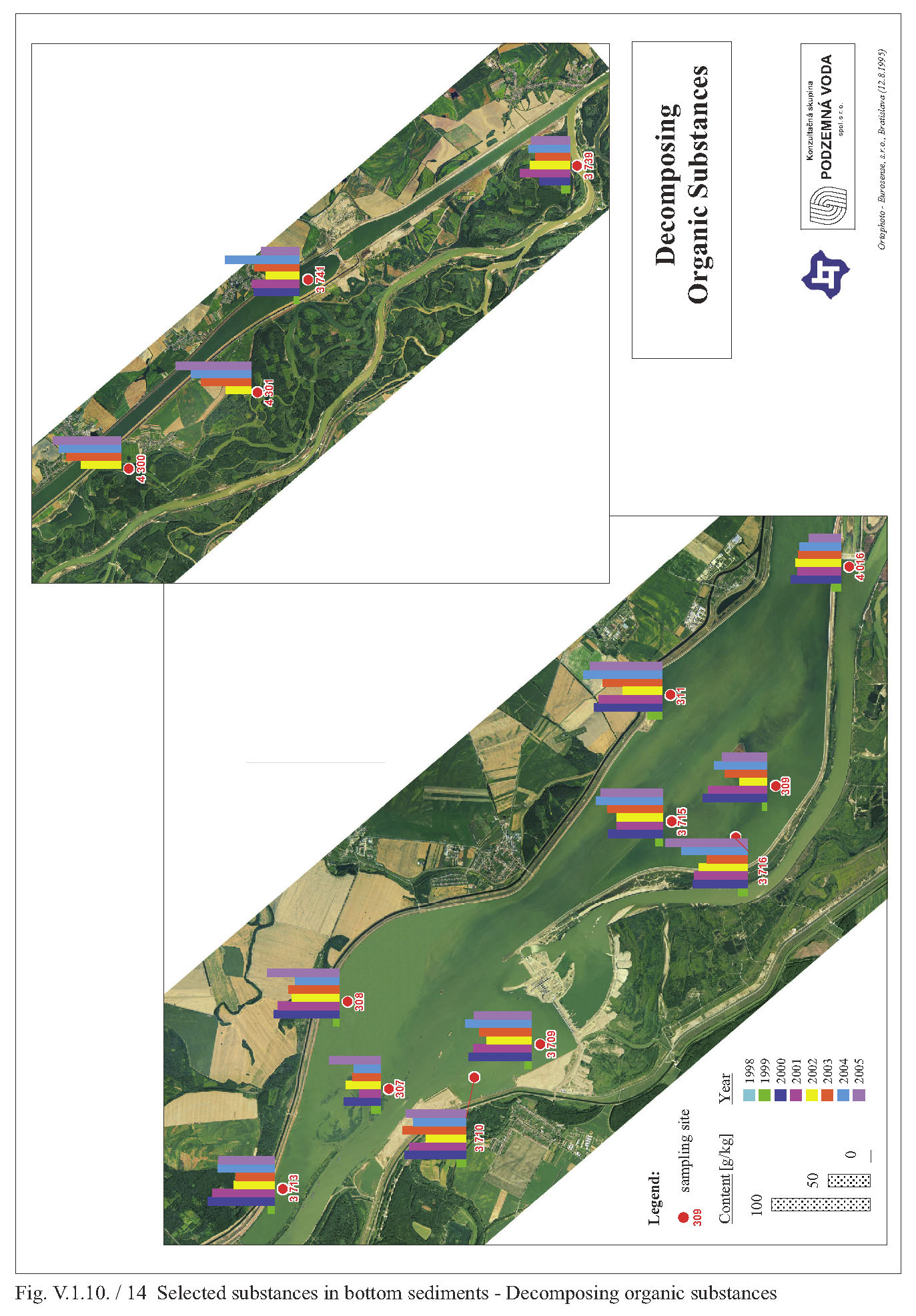
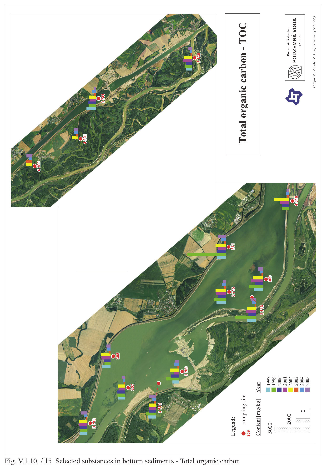
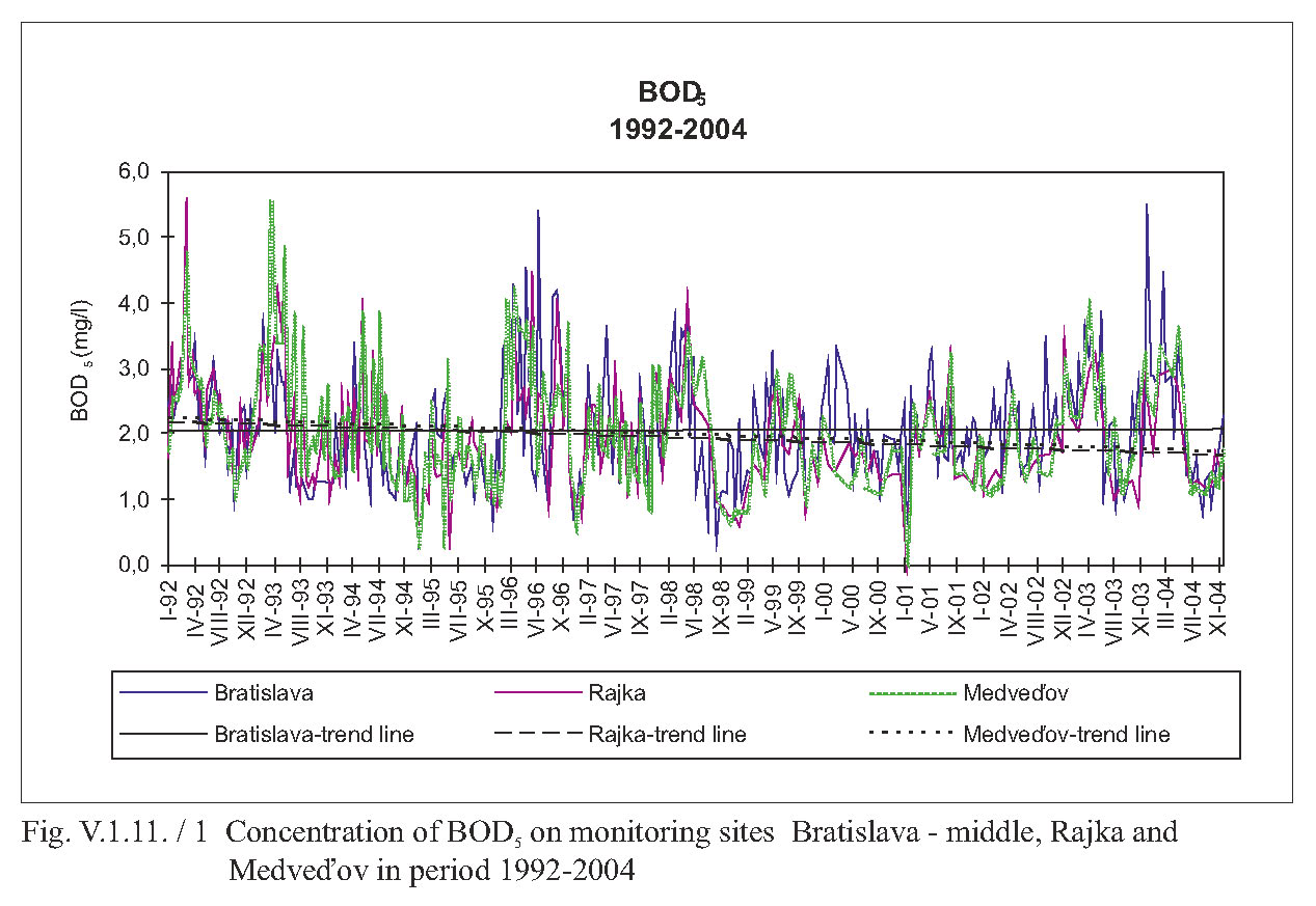
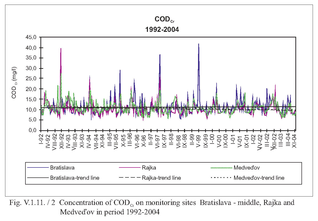
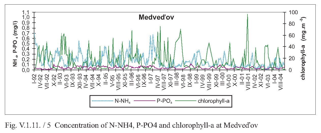
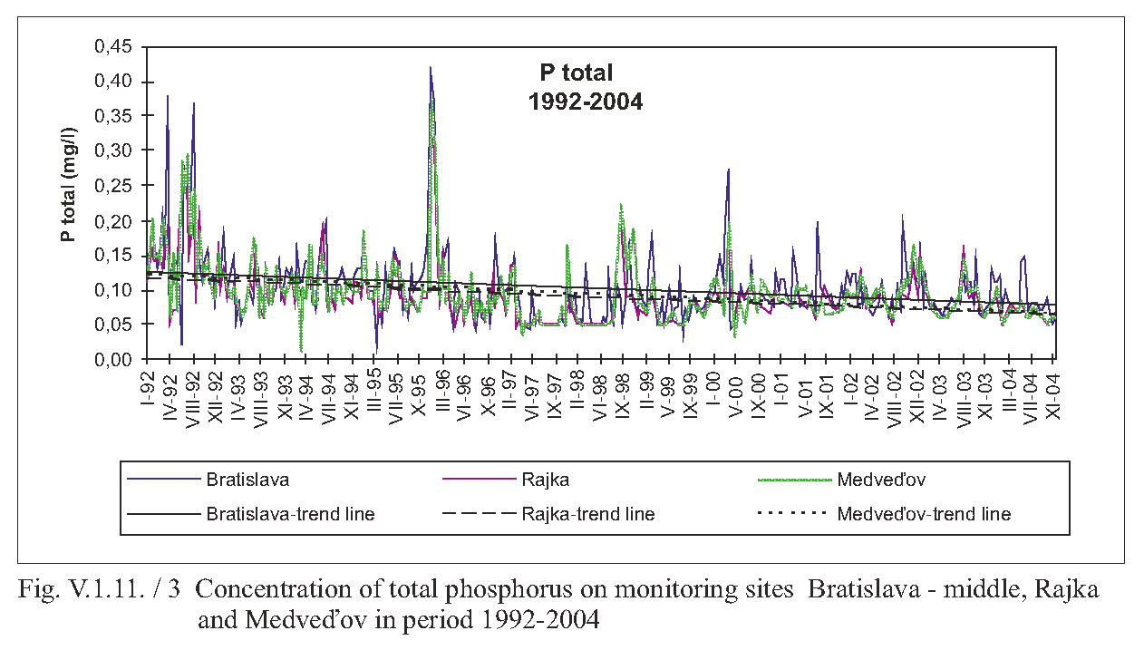
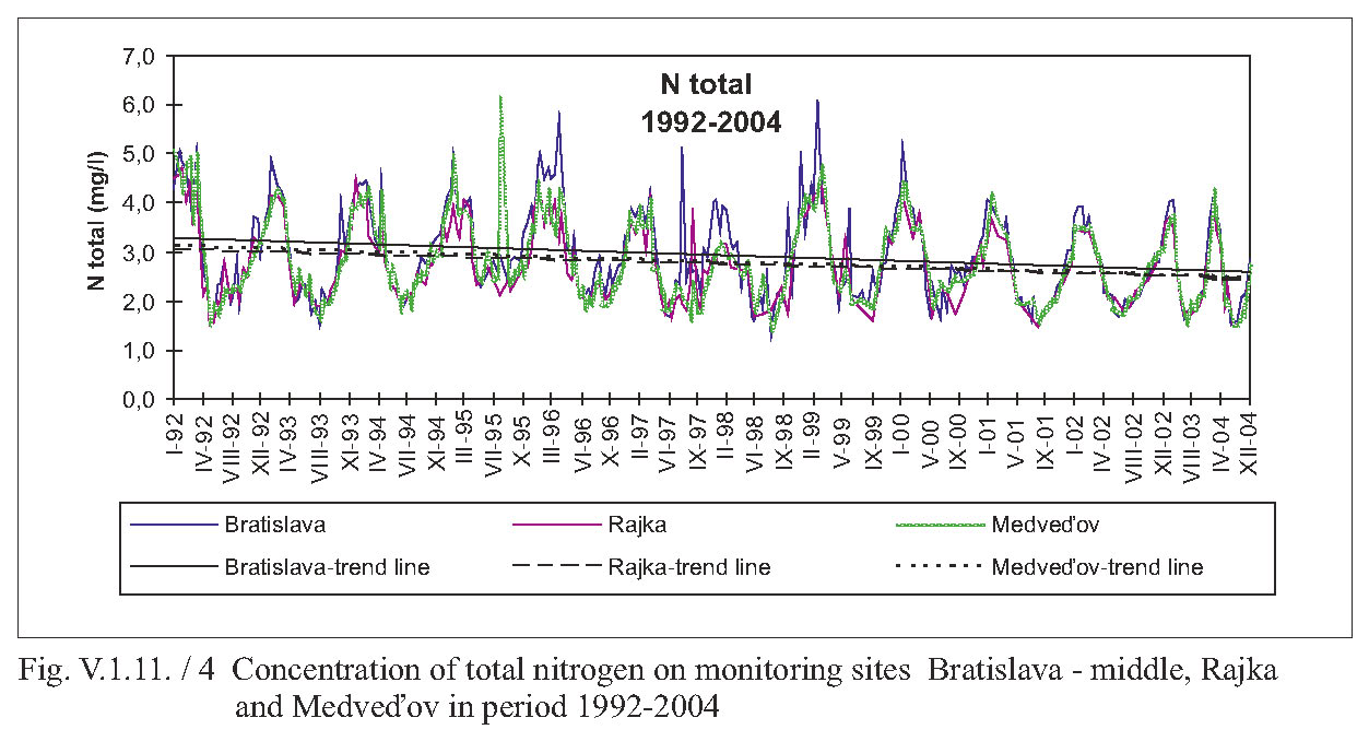
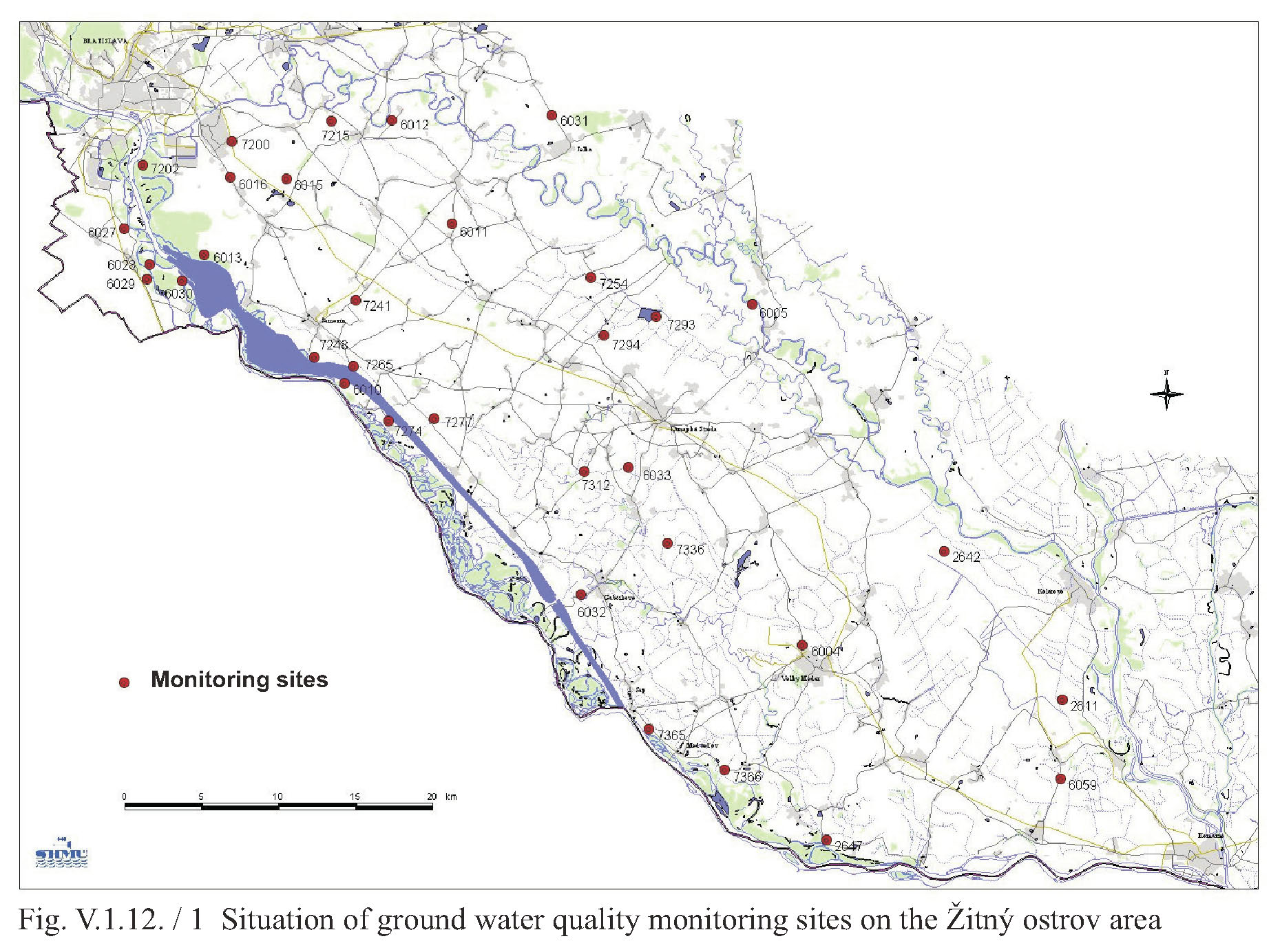
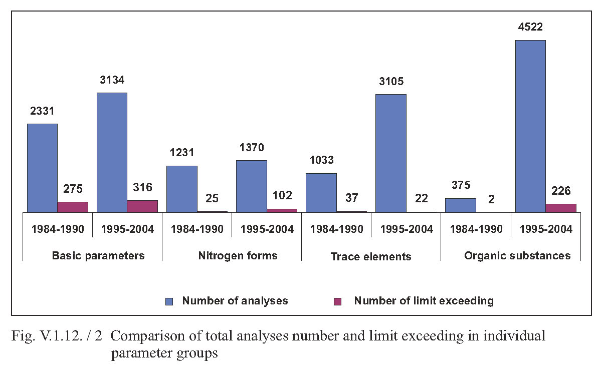
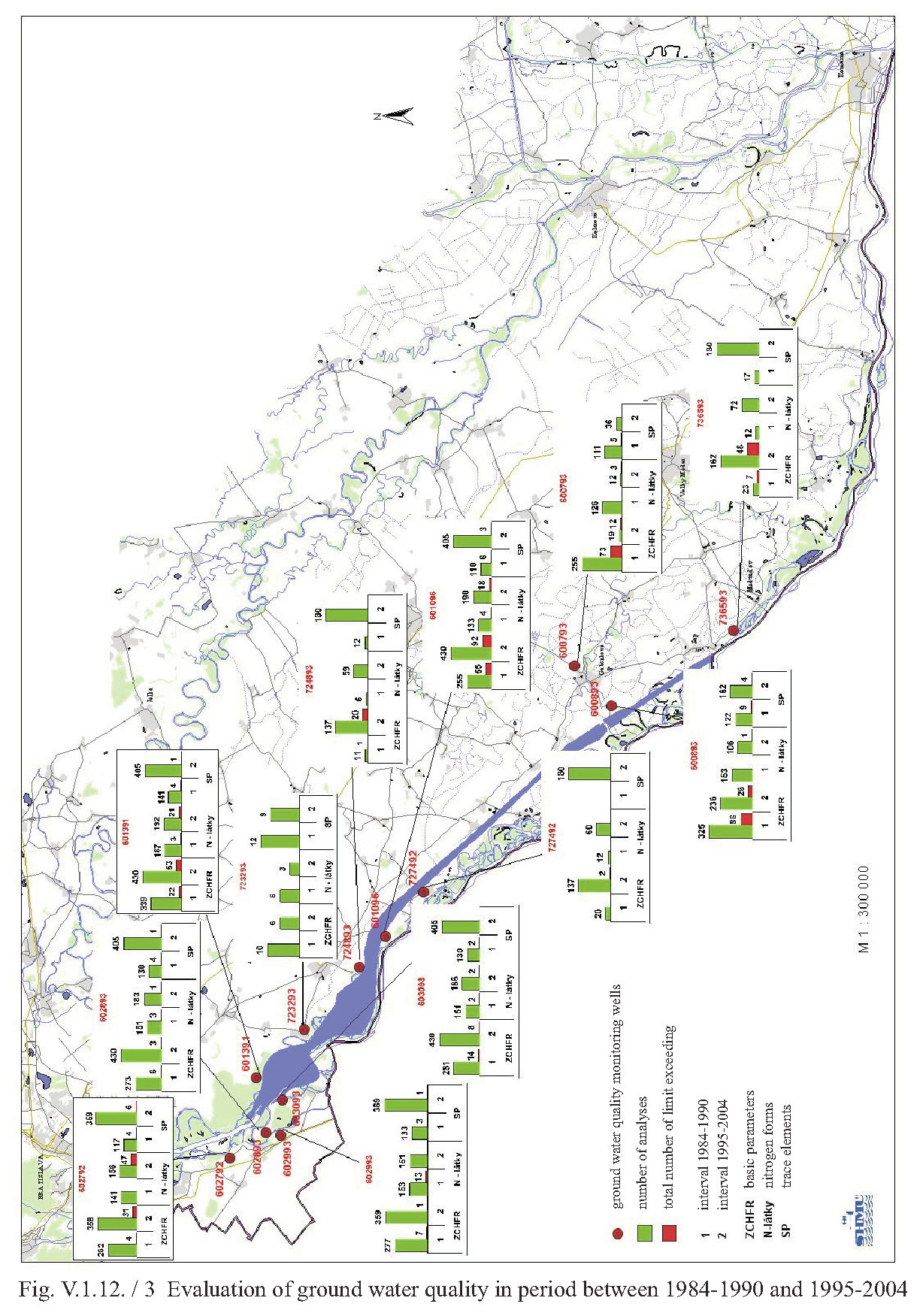
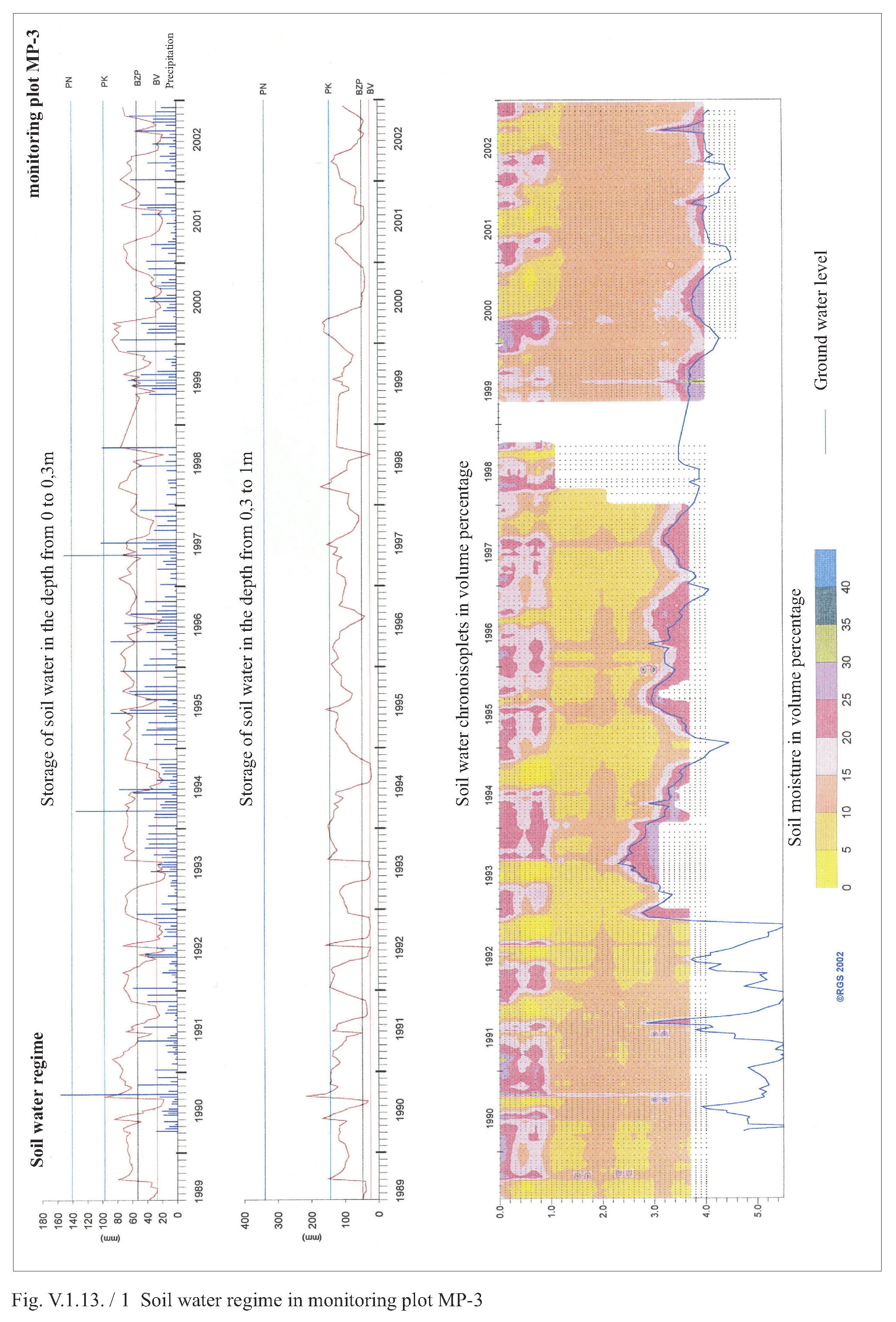
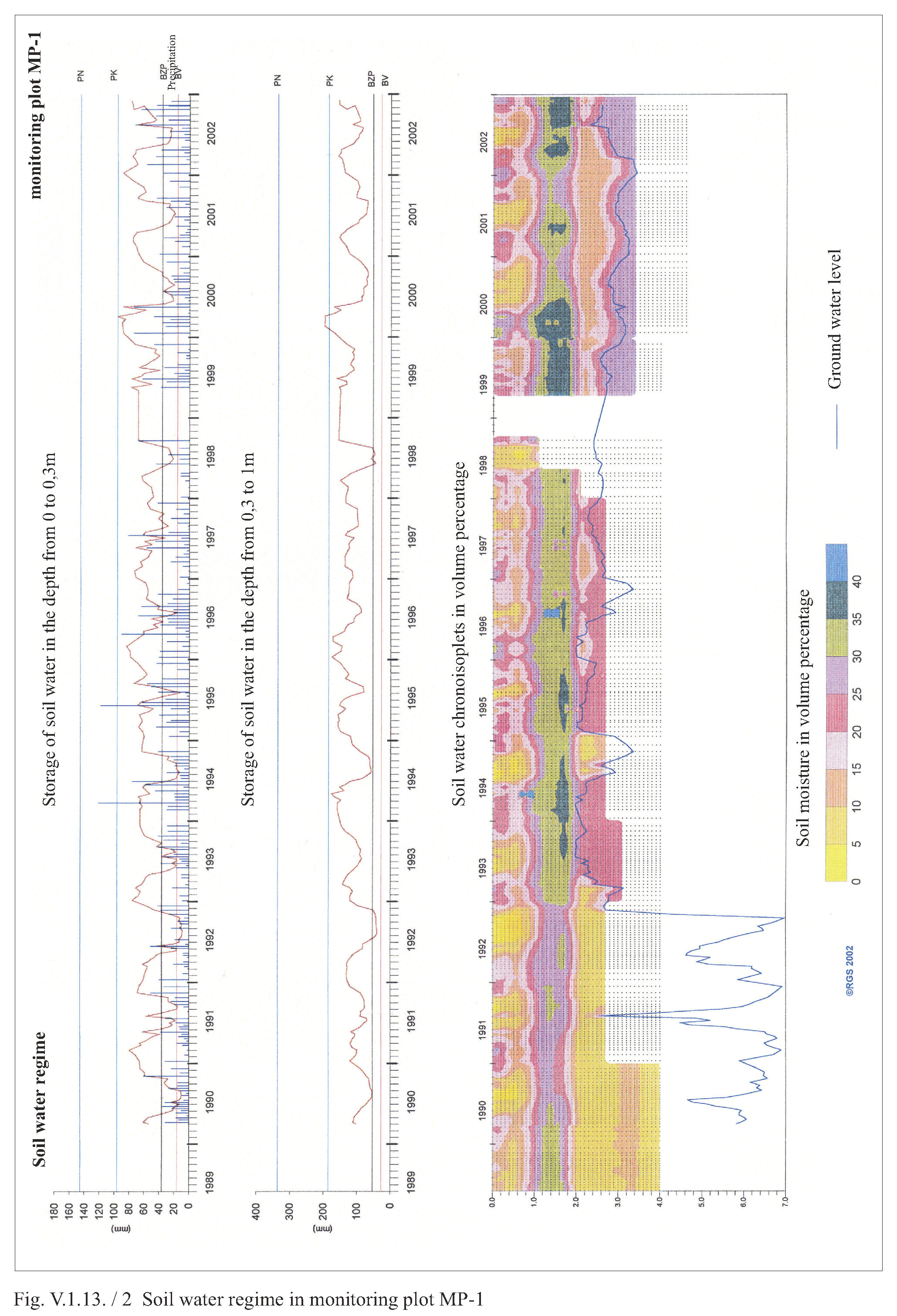
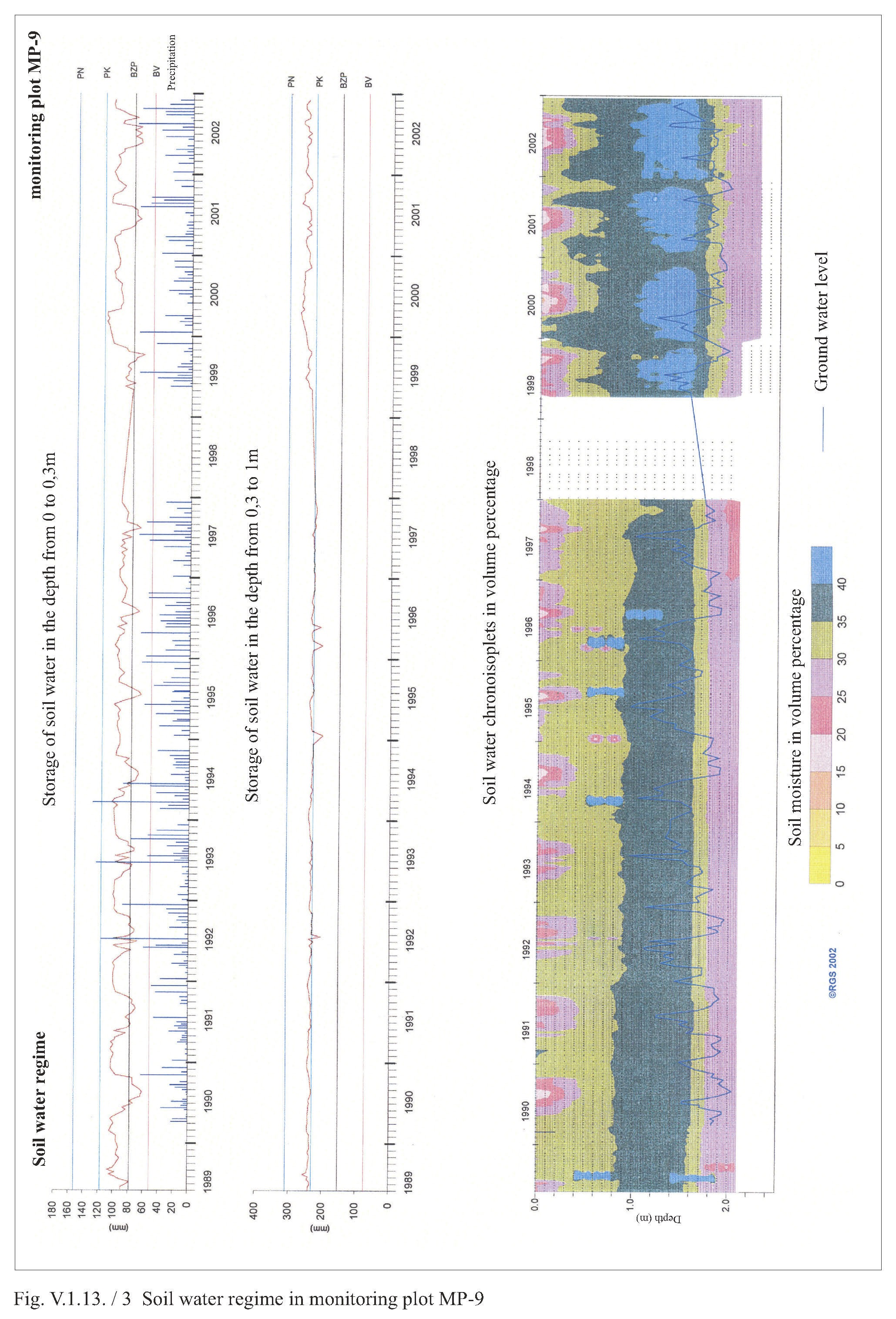
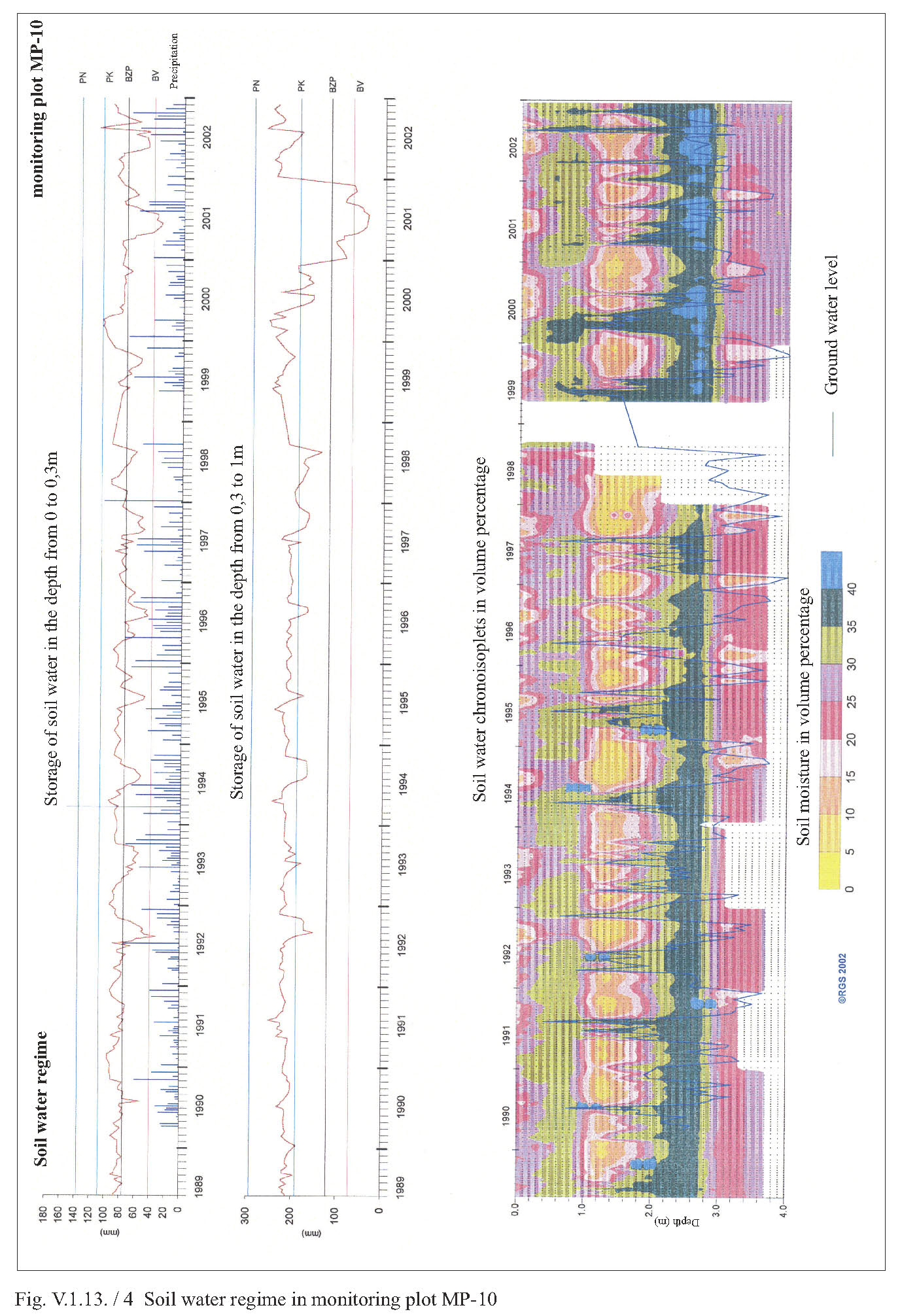