V. Monitoring of natural conditionsV.1. Climatic, hydrological and ground water conditionsV.1.1. Evaluation of the climate monitoring in the area of the Gabčíkovo hydraulic structuresOľga Majerčáková, Pavol Faško, Jozef Pecho, Pavel Šťastný Since beginning, monitoring of the area around the Gabčíkovo-Nagymaros project included the atmosphere. The basic aim was collection of all available meteorological data and data on air quality, reviewing whether the network of meteorological stations and stations for monitoring of air quality is sufficient and whether the monitored data can be continuously evaluated. At evaluation of climate and trends of the climate development, it was to be established and assessed whether filling of the Hrušov reservoir with water (reservoir according to the original project spread also on the Hungarian territory) would identify any measurable change in the climate. The evaluated territory (the Žitný ostrov area) spreads in the Slovak part of the Podunajská nížina (Danubian lowland) between the Danube and Little Danube. It is the southernmost part of Slovakia with very little variable topography. At edge of the Little Carpathians, the Danube antecedently (related to rising geological structures) deepened its riverbed and created the s. c. Devínska Brána gate upstream from Bratislava. Just through this gate the air masses from the northwest and north fall into the lowland, which causes fast changes in the weather. However, altitudinal zoning does not occur here. Monitoring network The network of meteorological stations is optimal in regard to the monitoring demands. The data are obtained from 12 meteorological stations. Five of them are climatologic stations, Bratislava - airport, Gabčíkovo, Žihárec, Hurbanovo and Kráľová pri Senci. They are distributed approximately on the circumference of the Žitný Ostrov Island. Seven stations are rain gauge stations: Jelka, Šamorín, Dunajská Streda, Jurová, Veľký Meder, Dedina mládeže and Komárno. The climatologic stations monitor the complete scale of meteorological elements; while the rain gauge stations observe atmospheric precipitation, snow cover and atmospheric phenomena. All stations have had a sufficiently long series of observation, so that a climatic “normal” (climatic characteristic for 30 years) could be established for all these stations beginning in 1931. Today we have to disposal two “normal” periods: 1931-1960 and 1960-1990. We particularly focused on the 30-year period from 1951-1980 as the prime period, which serves as the initial point for identification of possible climate changes resulting from global warming. The longest observation series available is that from the station in Hurbanovo, where temperature has been observed since 1871 and precipitation since 1876. The distribution of meteorological stations is given in Fig. 1. Evaluation of air quality refers to two categories: imissions and emissions: The category of imissions (industrial exhalants) also includes ozone, which has been evaluated separately on the Žitný Ostrov Island since 1995. Due to the short data series, we do not include it in this evaluation. The National network for monitoring of regional pollution consists of 7 stations, among which the station in Topoľníky well characterizes the rural landscape of Žitný Ostrov Island. Local pollution is bound to large urban and industrial areas. It is monitored in 4 stations in Bratislava and in one station in Šaľa. Emissions are monitored in the districts of Bratislava, Dunajská Streda, Komárno, Galanta and Šaľa. Evaluation of climatic conditions To characterize the climate, the following shows the air temperature and atmospheric precipitation, for the 5 climatologic stations over the two “normal” periods. From the viewpoint of dynamic climatologic evaluation, the weather can be divided into two categories: cyclonal and anti-cyclonal. In individual seasons, days with cyclonal type of weather predominate in the Danubian lowland, except for autumn, when cyclonal and anti-cyclonal conditions almost balance each other. When comparing the periods 1960-1990 and 1991-2004, no change in the number of cyclonal and anti-cyclonal air circulation occurred. Table.1. Average air temperatures and precipitation totals
In order to identify possible effects on the climatic conditions by the filling of the Čunovo reservoir (part of projected Hrušov reservoir) we compared the data from Gabčíkovo and Hurbanovo. By comparing temperature, air relative humidity and sum of atmospheric precipitation we found out that there is no significant difference between these elements in the two stations. Change and trends in maximum, minimum and amplitude of air temperature, identify impact of the reservoir water surface on the temperature regime. In the Gabčíkovo project case it does not happen. The annual maximum and minimum air temperatures, temperatures in the summer and winter half-year have grown almost equally. Only the average air minimum temperatures in the summer (warm half-years) have grown slower. This could be explained by the relatively strong decline in cloudiness in the summer half-years. The decline of cloudiness at night supports radiation and thus cooling of the near-ground air layer. Based on these results, it can be confirmed that declinations from “normal” values in each meteorological element had regional character, independent on reservoir. Similarly, as follows from all previous studies [6, 13, 14], even at the time horizon until 2004, there were not detected any effects from the construction and operation of the Gabčíkovo project on climatic conditions. Locally, in the arm system, increased water level and the area of water surface could moderately shift the microclimatic conditions to a more humid one. Trends of climate development Trends of general climate development can be best identified through long observation, which are not influenced by local conditions. The Hurbanovo meteorological observatory is situated so that it is not influenced by the Gabčíkovo project and its observations are some of the most accurate not only in Slovakia, but also in Central Europe. The data collected over a period of 90 years, including air temperature, atmospheric precipitation, relative air humidity and cloudiness indicate changes, which were evident already before construction of the Project. The average air temperature has increased since 1871 with a linear trend of 1.18 ºC/100 years. Average annual precipitation has decreased since 1876 with a linear trend of 70.1 mm/100 years, Fig. 2 and Fig. 3. The increase of average air temperature in the warm and cold half-years is approximately the same. Trends in precipitation from summer and winter half-years do not show such significant development as the air temperature, but they do confirm a decline in precipitation. The decline of the average annual relative air humidity, as well as average humidity for the warm and cold half-years, are almost insignificant. When comparing the period 1991-2004 with the period 1961-1990, which is the period of time before putting the Gabčíkovo project began operation, the increase of average monthly air temperatures is similar. In the case of monthly atmospheric precipitation, we compared the period 1991-2004 with the periods 1951-1980 and 1961-1990. Neither of the long-term 30-year averages of monthly precipitation is able to include all cases of precipitation variability. This is a result of large differences between the periods being compared. Differences in individual localities exceeded 20%. This fact makes, to certain degree, differences in monthly characteristic of precipitation between individual periods more difficult to interpret. The spatial and temporal variability of precipitation is, of course, greater than variability in other meteorological elements. Air quality Imissions: The imission pollution is based on regional air pollution, quality of precipitation water, and local air pollution. Regional pollution refers to pollution of the border layer of atmosphere approximately up to 1 km above the ground surface in a rural landscape, sufficient distance from local industrial or urban sources, where the vertical dispersion of industrial exhalants is already homogeneous. We compare the processed measurement with the critical level, i.e. the highest tolerable concentration of pollutants, which does not damage ecosystems. The critical level of pollutants is based on international standards. In the area of the Gabčíkovo project we obtain such data from the station Topoľníky, which was established in 1983 and was included in the European Monitoring network. Large urban and industrial areas directly affect the local air pollution. We find the local pollution mainly in the area of Bratislava and on the northern margin of the Danubian Lowland in the area of the town of Šaľa, which is relatively remote from the area monitored. The main polluter is chemical industry, energy production and transportation. The analysis of the monitored data shows that area of the Žitný Ostrov Island, except for Bratislava, represents a relatively unpolluted landscape. Only in urban and industrial areas does it reach a degree of moderate pollution. Pollution increases in the city of Bratislava and spreads to the villages Rovinka, Hamuliakovo and Kalinkovo. Local pollution declines southeast of Bratislava. Within 10-12 km of the city we observe only the background values of pollutants. Bratislava is very well ventilated. This results from the large frequency of northwest wind (proportion 40-50%) with relatively high wind velocities. Natural acidity of precipitation water pH is 5.65. Water with acidity below this level is considered acid. The acidity of Bratislava’s precipitation has been monitored since 1977 and in Topoľníky since 1983. Time series of pH values in Bratislava has greatly increased (in the late 1970s the pH values were around 4.3, in the early 1990s they exceeded 5), hence the precipitation acidity gradually decreased. Decrease in concentration of dominant sulphates in precipitation water approximately corresponds to decline of sulphate emission in Europe. When comparing Topoľníky station with Bratislava, the precipitation from the Topoľníky has a changeable acidity; the pH varies between 4.4-5.6. In some months the pH exceeds 6. This is caused by higher concentration of dust in the landscape, which neutralizes the precipitation water acidity. We estimate that 60% of long-range pollutants, including regional pollution and precipitation acidity reach Slovakia from abroad. Emissions: Until approximately 2000, emission pollution steadily decreased. This resulted from reduced production, reduced energy use, change of combustibles in favour of high-grade energy resources and wider application of separation technologies. After 2000 emission pollution also decreased slightly, but not as consistently as before. This is caused by local increase in production and a partial return to classical combustibles. Overall, in Slovakia emissions of heavy metals strongly dropped. In the last 15 years, the amount of selenium decreased to 4/5, cadmium to 3/5, zinc to 1/2, copper and mercury to 1/4, lead and nickel to 2/5 and amount of arsenic and chrome to 1/10. Emission of the basic pollutants (solid pollutants SO2, NOx and CO) reaches the highest values in Bratislava. The surrounding area of Bratislava is relatively clean in regard to emitted pollution. The remaining part of the Žitný Ostrov Island has relatively low values of the emitted pollution. The Gabčíkovo project has a positive effect on air quality because it produces clear, renewable, and waste less energy, which replaces energy from burning fossil resources and it absorbs a part of pollutants in the air, especially in the areas with increased humidity conditions in floodplain forests. Impact of climate development on water resources A time series of climatic elements indicate that the climate is changing in the area. Its possible future development is presented in so called scenarios of climate changes, which have been created in the Slovak hydrometeorological institute and at the Faculty of Mathematics, Physics and Informatics of Comenius University. Lapin and other authors, for example [6, 7, 8, 17, 18], were significant contributors. According to the scenarios, we can expect an increase in average air temperature approximately by 3°C in the next century; precipitation will slightly decrease or will change insignificantly. Distribution of precipitation in the course of a year can change and a decrease in summer season (the season with the most precipitation) is expected. There is possibility of periods of more intense precipitation and longer periods without precipitation. Both of these factors strongly influence surface, ground and soil water resources. The effect of the possible climate changes on run of and surface water regime was dealt with, for example, in [20, 21, 1, 3, 15, 13, 16]. Possible effect of climatic changes on ground water resources and soil moisture is described in [2, 4, 5, 23, 19, 24]. A general view of sensitivity and vulnerability of surface and ground waters resources is characterized by maps having been elaborated, for example, by [12, 15, 20, 5]. All these publications show that the area of South Slovakia is the region most at risk. In spite of this, the Third National Report about Climate changes (2001) presents statement: ”We recommend to pay a special attention to protection of the unique source of ground water in the Žitný Ostrov Island, which probably will remain of the existing level also in future”. The reason for this recommendation is that the Danube supplies the ground water resources downstream from Bratislava. In the area of the Žitný Ostrov Island the Danube is an allochtonous river. It has relatively balanced water regimen originating in the upstream areas. We do not expect a strong change in the discharge regime of the Danube in the future. Summary The climatologic monitoring and monitoring of air quality in the area of the Gabčíkovo project is sufficient and reliable. The collected data are continuously evaluated. The length of observation time makes it possible to evaluate the influence of the Gabčíkovo structures on the surrounding area. After 15 years of detailed monitoring and evaluation, it can be concluded that:
References
V.1.2. Changes in the Danube riverbed from Bratislava to Komárno in the period prior to its regulation for medium water (1886-1896)Peter Pišút Natural conditions in the late glacial and mainly postglacial period and their stabilizing under the anthropogenous influence resulted in the present state of the Danube bifurcating into the main channel river arm (The Danube), Little Danube and Mosoni Danube. Geological, geomorphologic and paleoecological investigations have gradually piece together a precise picture about development of lowland rivers of the periglacial zone and foreground of the Alps, including the Danube. According to them, phases of higher or lower flood and geomorphological activity repeatedly occurred in the last 11,000 years. They strongly influenced behaviour of rivers and structure of river terraces. The late Neolithic period and Bronze Age (ca. 4500 - 2500 BC) were periods of relatively low discharges and low flood activity (low frequency and magnitude of floods) in the basins of the Upper Danube, Main River [40] or Morava River [30]. Archaeological investigations in the historical centre of Bratislava confirm that at that time there were particularly favourable conditions for human settlements directly in the space area of the Danube floodplain [6]. In the younger and later Bronze Age, there was a drier climate with lower discharges. It was possible to colonize lower lying grounds with an altitude of only 134 m a.s.l. in the Danube floodplain. On the other hand, during the relatively more humid climatic micro-periods in a part of Eneolith and later in the earlier Iron Age, it was only possible to build up settlements in areas with a minimum altitude of 136-137 m a.s.l. [3]. The Roman period and period of migration of peoples also represented a relative sedimentation calmness (also in the Morava river [30]). According to analyses of bog-oaks from the gravel terraces, the climatically conditioned periods of increased flood and river activity lasted only shortly in the Holocene period (at most several hundred years), except for the youngest phases, in which a strong anthropic activity and increased discharge due to deforestation were observed. This phase began at the Upper and Middle Danube in the early Middle Ages, about 580 – 770 AD [6]. Hydrographic conditions during the late Middle Ages (13th – 14th century) Geographically the most significant anabranch in this territory was the Č a l o v (Csalló in Hungarian), the medieval Little Danube, because it separated the biggest island of the C s a l l ó k ö z (for details about the development of this name see [36]). In Hungarian, this name represents a characteristic type of toponyms in alluvia, which where derived from the name of the smaller river or arm, which created with the larger river (arm) the interfluvium [17]. The Čalov arm turned to the south at Topolníky (= the village of Zalonta Zakalus, today Opatovský Sokolec, laid in 1276 already between the Čalov and Váh River), where its flow passed through extensive marshes in the oldest Danube palaeomeandres. Therefore the Čalov did not mouth into the Váh River at Kolárovo, but into the Danube at Čičov (Fig. 1). However, southwards from the Okoč village it was known by the name of M i l l é r (Myler 1268, 1380), because inland waters from marshes in the area of the villages of Vrakúň - Boheľov - Veľký Meder entered the arm. Thus, the Žitný Ostrov Island, in its present form, did not exist in 13th und 14th centuries. The island formation „Medzičalovie“ (“the Čalov interfluvium”) also had alternative names derived from names of significant settlements: in 1339 according to Ráb (lat. Iaurinium, today Győr) - Insula Iaurien(sis), que et Magna dicitur, i. e.”The island of Ráb, also called Great” (medieval map by A. Dulcerti). After the municipal privilege had been awarded to Šamorín, it was also called after this town´s name of that time: Insula Sanc(t)e Marie que dicitur Magna (map of M. Pizigani, 1367, [36]. Against the rehashed hypothesis (c. f. [34, 35]) in which the čalov represented the Danube main stream until modern times, speaks not only the medieval existence under a name of its own [17], but also the latest knowledge about structure of the Danube basin (program DANREG) and morphometric parameters of its older palaeomeanders (near villages Vrakuňa, Most n. Ostrove, etc.). The notice about low discharge in the Čalov, allegedly due to building up of the only mill at Podunajské Biskupice, dated to the period between 1310-1342 [39] also contradict this hypothesis indirectly. The flow-system of the medieval Čalov also consisted of another, often tens km long, parallel arms. The northernmost was Č i e r n a v o d a [32], originally called P l a z o v, because of its creeping, slithering (= in Slovak “plaziaci sa”) meandering stream (with the čalov it formed an interfluvium called P l a z ó k ö z). The parallel arm B e l d é r (1301 Bulder; 1430 Belderduna, alio nomine Nagherduna; 1517 Nagbelder; Kysbewlder, sive hayoswth) existed between the villages Orechová Potôň and Trhová Hradská. Its remnant is the present Klátovské rameno arm. In the subsystem of southern arms, the longest (at least 50 km) and geographically the most significant arm *Č e l i c (resp. *Čilic / Čelec) separated from the Danube at Čilistov. Its remnant is the present brook Či l í z (aqua Chelch, 1270; fluvius Chylch, 1272; Chelz, 1330; Chelez, 1400). This anabranch flew alongside the villages of Dobrohošť, Rohovce, Horný Bar, Bodíky, Baka, Gabčíkovo, Pataš, Baloň and Kľúčovec, joining the Danube between Kľúčovec and Čičov. The note from 1272 Chelch ibi vocatur Agagus i.e. in Hungarian Agyagos „= loamy“[19] reveals that even in 13th century Čilíz did not carry much water, although it had more water than later. In 1330 the Čilíz was located in the same place as the present Danube main channel between Bodíky (in Hungarian Nagy Bodak) and Kis Bodak. The main channel must have been situated more southwest at that time. Written records show that the Danube in the stretch Bratislava – Rusovce had a similar character as later in 18th and 19th century. In short stretches it formed several relatively stable islands. Similarly, as in the territory of Bratislava [7], also a wide main stream (ad magnum Danubium 1258; ad Danubium Magnum 1305-6) is known. More than 10 km long parallel narrow side arms accompanied it. On the right side it was the Kopčianske rameno arm also known as G e r i n n [7, 29]¸ and on the left side was the Starduna, arm [1] around an island, identical with the Vlčie Hrdlo (Farkas Torok), which powered the ship mills until the 19th century [8]. Between Hamuliakovo and Šamorín a branching into longer arms - K o r o u s d u n a (Starý Dunaj) and P r a n d u n a is documented. One of them was probably identical to the present day Mosoni Danube arm (Mošonský Dunaj), whereas the second arm could probably be matched with the disappeared stream flowing on the western edge of Püski, Mosondarnó and Zseli villages. This stream became the border between the county of Bratislava and Moson in the 11th century [39]. Anastomosing character of the channel planform (branching and rejoining irregularly to produce a net-like pattern) is also documented in the area of Sap – Čičov / Vének. In 13th century the Little Danube still did not exist where it does today, between Topoľníky and Kolárovo. Thus the Lower Žitný Ostrov Island area of today (heading east from the Topoľníky – Holiare – Čičov) represented a separate geographical unit, s.c. V á g k ö z - near or at the Váh River - („Privažie“ or „Medzivažie“). The Váh and paralelly flowing Dudváh, which joined the Váh River southeast of Čalovec (Fig. 1) were dominant streams of the Komárno castle area. The area south of Žihárec, between both streams, was occupied by extensive marshy floodplain (marsh Sampsa, 1252). Changes in river streams in 15th century For the first time we find the Žitný Ostrov Island approximately in its present form on the map of Lazar Deák in 1528. According to that map, sometime after 1378 (at that time Čičov was still situated „in Vagkuz“) essential changes in hydrography occurred in the area between Bratislava and Komárno. They resulted in creation of a new 16 km long stretch of the Little Danube from Topoľníky to Kolárovo [35]. Simultaneously, the former area of the historical Vágköz between Komárno, Čičov, Topoľníky and Kolárovo became a part of the considerably enlarged Žitný Ostrov Island, which included the strategically significant Komárno. The landscape changes were also documented in written notes and maps of the time when they referred to Žitný Ostrov Island by the alternate name, according to Komárno, Insula Comaromiensis. This name was used by Mikuláš Oláh in 1536, Š. Münster in 1554 [32], and by W. Meyerpeck on his 1594 map [36]. Although the above change could be caused by an intentional human intervention, it was most probably a result of the Danube increased flood and lateral activity in the late 14th and first quarter of the 15th century. A well-known document from 1426 illustrates the changes in the subsystem of the southern arms in the area upstream from Šamorín (for complete transcription see [8]). The changes in the riverbed after 1400 are also reflected in disputes over fishing facilities on at least 6 islands at a relatively short stretch (of the Danube) Vének – Klížska Nemá – Gönyű. In the Austrian and Bavarian stretch of the Danube, great and numerous floods occurred in 1402, and from 1405 to 1408 [43]. Increased activity of the Danube in the Žitný Ostrov Island at that time coincides with a period of increased soil erosion and transport of sediments by the Naab and Regen rivers in the northern part of the Danube Bavarian stretch. This activity also coincides with the most productive period for the local iron industry in 14th –17th century [6]. The changing climate and increasing human activities in the valleys of the Danube and Isar Rivers were responsible for deposition of the youngest gravel terrace H6 dated to the time from the 14th to the mid 18th century (before 1769 on lower Isar), [38]. In the late Middle Ages, sedimentation of flood loams also culminated in the Morava River, where most settlements in the floodplain existed only up to the 12th –13th century [30]. Increased discharges probably also resulted in forming a more or less single-thread main channel of the Danube in the stretch from Bodíky to Bajč. As for the Little Danube, interesting information follows the note from 1422 about subsequent years of repeated flooding making fieldwork impossible in the area of Čalovec. This most probably documents the first phase of origin of the Little Danube new stream, when Čalov first broke into the Dudváh River situated 6 km away. Floods in surrounding areas were a logical consequence of waters over-spilling from the Dudváh channel, whose capacity was not adapted to the new discharge situation. In the second phase another 10 km stretch of the Čalov riverbed was also formed, which extended down to Kolárovo. Gradual siltation and shallowing of at least 24 km long remnant of the Dudváh riverbed started after the change of the Čalov riverbed. However, even in the 18th century, Dudváh was at least periodically active. Brestovec village had 2 mills on Dudváh still in 1737 [1]. A 1789 list of fishponds in the area of Veľký Meder [2] mentions 9 lakes including the name Millér in their name (Holló-, Határ-, Kigyós-, Nagytótárka-, Járom-, Körtefás-, Kő-, Megye- and Hidnál levő hugyó millér), which illustrate gradual terrestrialization of the abandoned lower Čalov and its transformation into a system of isolated water bodies. Some stretches of its riverbed were transformed into drainage canals in 19th century [11]. The Danube in 16th and 17th century In connection with hydroclimatic manifestations of the s. c. Little Ice Age (a colder and more humid climatic period of the past millennium), frequency and magnitude of floods increased in more European rivers in the second half of 16th century [5]. Also at the Danube, great and numerous floods affected Bratislava and Žitný Ostrov Island in 1568, 1569, 1570, 1572, 1573, 1587, etc. [14, 34, 15, 37]. In this period (the break of the Danube meander at Wolfsthal also happened during this period, [29]), geomorphological activity of the Danube also increased and simultaneously the discharge became distributed more evenly into three principal arms. As a result the volume of water in the northern arm significantly increased, so that this period became The Golden Age of Čalov. The increased water flow could also have been caused by favourable inflow conditions at Bratislava. The upper entrance of Čalov was situated in the direction of the Danube spillway main channel into the area of Vydrica and the suburb of the Rybárske predmestie suburb. At that time, Čalov (=Little Danube) already at Bratislava in the present Ružinov reached a width of 150-200 m [27] and its channel width at Komárno was at least equal with that of the “Old” Danube. After Čalov migrated into Váh at Kolárovo in 15th century, it obtained a new significance from the viewpoint of shipping, especially in the transport of goods upstream [42]. In addition, in the time of the Ottoman threat it became an important road for shipping provisions to fortresses, especially after completion of the most modern European fortress of that time in Nové Zámky (1573), which was only 14 km from Kolárovo. Therefore, the Little Danube began to be referred to by the Hungarian and German names of Nové Zámky (Ramus Érsék Újváriensis, Neuhäusler Donau Arm, Érsekújvári Ág). The fact that the locality Aszód near Topoľníky [1] obtained a leading position in profitable fishing of beluga (Huso huso) and other great sturgeons in 16th century (besides of Komárno and Kolárovo) is also connected with origin of the new stretch of the Little Danube and increased discharges in it. Culmination of water discharge through the Little Danube in the second half of 17th century is reflected on maps of the Žitný Ostrov Island [10, 32], local maps and vistas of fortresses in Kolárovo (Gúta) in 1664, Fig. 2) and Komárno (see [15]), toponyms from the area of the Vážsky Danube River [32] as well as parameters of the preserved paleomeanders. During some of the floods of that period – possibly in 1688 [8] another upper entrance to the Little Danube arose by avulsion (= an abrupt change in the course of a stream resulting in the creation of several kilometres long new channel) in the 5 km stretch between Prievoz and Komárov - later known as W a r t l i n g arm – crossing the existing arm F a r k a s T o r o k (Vlčie Hrdlo). At the same time, meander of the Little Danube flowing around the village Vrakuňa, developing here continuously from the 13th century by an lateral erosion of 1.67 m per annum [25], was broken and cut-off. Thus, Vrakuňa became a geographical part of Žitný Ostrov Island [8]. Intensification of fluvial activity of the Danube in 18th and 19th century Since the late 17th century the discharge in the Little Danube definitely decreased, probably as a result of the terrain changes in Bratislava and gradual shifting of its upper entrance farther away from the city [14, 3]. In addition, efforts to maintain its navigability increasingly conflicted with the expanding mill trade, especially after 1751 [8, 42]. Thus at latest in 1712 (map by J. Marinoni), the present middle arm cartographically represented the unambiguous main channel, whose discharge increased when compared with the discharge of the preceding period. According to the Mikovíni´s map of the County of Bratislava (1735) and part of Žitný Ostrov Island [31], Kováč´s map of the Moson county [33], as well as according to local maps [21, 25], the main channel formed six large regular meanders between Šamorín and Sap in the first third of 18th century. Minor parallel arms also carried some water ([18], map on p. 206). An intensive lateral development of smaller meander loops in the form of four subsequent cut-offs is documented in the stretch at the rkm 1824 – 1831 [21]. Their remnants are the palaeo-meanders „Pálfi sziget“ and „Alsó Zátony“ on the Hungarian side and the plesiopotamal type oxbow Kráľovská lúka (biota monitoring plot - MP 10) on the Slovak river arm. Since the 1720s, the increasing activity of the main stream and its side arms was demonstrated not only by frequent dike breaches, but particularly by undermining and destruction of protective dikes, which had been built all along the Danube at that time. Strengthening or substitution of the eroded stretches with new dikes situated further from the river required manpower, considerable funds and coordination at the level of the county administration [8, 11]. According to a 1729 report by S. Mikovíni functioning as the county engineer, the main channel threatened to shift into the arm flowing downstream from the Vojka village and to flood the lower part of Žitný Ostrov Island. In 1730, the Danube destroyed a major part of Bodíky. By 1736, according to Mikovíni´s proposal [33], the main channel of the Danube was diverted by digging the first known artificial Danube meander cut-off in the length of 950 m and initial width of 29 m at Vojka village. In connection with the last gust of the Little Ice Age, approximately since 1753, the hard winters with large amounts of snow were more frequent and frequency of high waters also increased. Freezing of the Danube was accompanied by dangerous ice floods, which had great geomorphological effects. In addition, in the 18th century the surface runoff increased as result of introducing new agricultural methods and crop plants (potato, maize, tobacco). The general increase of sediment supply resulted in the increased lateral activity of the rivers. In the Danube it was manifested by the accelerated development and change of its meander size. For example, while the meander at Wolfsthal (16th century) had a radius of about 750 m at the time of rupture, other meanders in the 18th – 19th century reached a radius of even 1100-1300 m [23, 29]. The sediment migration was indicated by a considerable increase in the number and total area of bare deposits, still not overgrown by pioneer vegetation of flood plain forests (bare lateral and central gravel banks in the riverbed) (Fig. 3). Bars and new islands pushed the stream laterally and caused bilateral widening of the riverbed. Large surfaces of point bars on the map indicate strong lateral erosion on the opposite riverbanks. For example in Bratislava during the period of 1712-1779, the average values of lateral erosion (depending on the position in the meander bends) reached at least 7.5 m (max. even 37 m) a year [25]. In the valley of the upper Danube and the Isar river the changing climate and the anthropogenous activities in the area were responsible for forming the youngest clearly distinguished terrace H7, dated to the period from the mid-18th century up to the later Danube regulation [38]. Until now, the chronological sequence of natural changes in the riverbed and anthropogenous regulative interventions, which definitively resulted in permanent instability of the Danube riverbed, has been best documented (since 1712) in the area of Bratislava [25], which simultaneously had the key control over the future of the Little Danube. The ice jams in the severe winters of 1766-1768 caused a shift of the main stream of the Danube at Pečenský Ostrov Island (the present day rkm 1869.5 – 1873) [22]. Subsequently, a 7 km long embankment of Petržalka (=Engerau) was built downstream from the Austrian village of Wolfsthal in order to protect the Petržalka village and the important road to Vienna. It was one of the first known closures of a side arm (1777). The major, 6 km long and more than 200 m wide Danube right side Chorvátske rameno arm in Petržalka significantly relieved the main channel until this closure. It shortened and straightened Danube at Bratislava, what resulted within a short time in breach of opposite-direction meanders of the Danube (1780) between Petržalka village and the Vlčie hrdlo arm at the present day rkm 1862-1864. The channel width gradually increased twofold from 165 m in 1774 to 339 m in 1816 [25]. Simultaneously the ferry between the villages Kopčany and Biskupice located here since the Middle Age ceased to exist. The river probably also responded by local bottom erosion and decrease in ground water level after 1779 which explains the sudden shallowing and silting of the Mlynské rameno arm, representing the main upstream entrance to the Little Danube [25]. In order to maintain navigability in the Little Danube a regulation structure (stone groins and bank revetment) in the upstream entrance of Wartling arm was built up in 1790-1791. These measures increased stream velocity and lateral erosion along the Little Danube, especially in the stretch downstream from the Horné Mýto village and on the Vážsky Dunaj [11]. This problem existed even after 1816, when the training structure at Wartling was washed away by the Danube [25]. The systematic river changes, at least partially caused by the increased bedload transport from the area of Bratislava, are already well visible on the I. military maps from 1783-1784 (Fig. 3). Out of numerous sand and gravel bars in the widened riverbed (at Vojka and Bodíky), breaches of six regular meanders between Šamorín and Sap are visible. This is also confirmed by the Lichterstern´s map (1791). Approximately since 1788, reports about severe lateral erosion, endangerment or replacement of the dikes at Szemét (Kalinkovo), Gútor (Hamuliakovo), Čilistov, Šamorín, Dobrohošť, Vojka and Šuľany [8] started to appear more often in the administrative records of the County of Bratislava. The strong lateral erosion in two large meanders required diversion of the Danube main stream at Čičov, where a further artificial cut off (length 380 m, initial width 38 m) was implemented after much dispute in 1798 [11]. A relic of the cut off meanders is the present day Čičovské mŕtve rameno oxbow, and on the right bank the paleomeander at Bajcs (Fig. 4) with a diameter more than 900 m (rkm 1799 - 1802); both formations did not exist on 1783 maps [41]. A product of the Little Ice Age from the late 18th and early 19th century is large elevated gravel accumulations, which originated from major point bars in the Danube riverbed. Some of them were exploited and now artificial lakes exist there (the Draždiak in Petržalka), others form now cores of some natural reserves - Ostrov Kopáč Island (the present day Monitoring plot of biota - MP 1), Gajc and Ostrovné lúčky (MP No. 3), nature monuments Panský diel and Protected Site Bajdel [25]. In the first half of the 19th century three catastrophic ice floods occurred. They subsequently destroyed Bratislava (January 1809), Vienna (1830) and Buda and Pešť (1838). The ice flood in January 1809 destroyed the first side-arm closure and re-activated the Chorvátske rameno arm after 33 years of siltation. Oversaturation of the Danube main channel with sediments, its widening and tendency to braiding are clearly illustrated by military maps (II. Military mapping, 1840). The arms Biskupické rameno and Rusovské rameno originated from the breach of the great meander at Kopáč between 1826-1830. Enlarging of mid-channel bars (after 1840 [16]) produced the present day MP 18 (Kľúčovec, Sporná sihoť; Fig. 4) and Istragov Island (MP 14), where two gamekeeper’s cottages fell victim to the Danube left-side lateral erosion. Altogether, between 1855-1866 the Danube eroded away 2000 quadrate “Morgens” (a historical German surface unit approximately equivalent to an acre, = 1150 ha) [8]. The 1880-s Danube regulation in Austria caused the last increase of lateral erosion of the still unregulated Danube downstream from Bratislava [11]. Anthropogenous interventions in the period up to the systematic regulation Already in the far past, the Danube waters were manipulated and smaller periodically active arms were partitioned and dammed for purposes of fishing [9]. Numerous pile and wicker constructions, especially the stable beluga weirs, dammed the side arms or in the case of narrower arms dammed the whole stream, these could have had considerable impact on the deposition in the riverbeds [1]. These facilities were represented by “sedza” (Hungarian cége) and “vojsa/vejsa” (Hungarian vejsze) traps, which were fishing fences and gorges (the Farkas Torok arm). The most typical technical appliances of the feudal period – boat and pile mills also could have influenced the erosion-sedimentation processes by enhancing lateral erosion with surf, transformation of water streams into mill-races, construction of submerged dams or by sedimentation downstream from the mills [17, 39, 42]. Fascines and earthen bridges that crossed the old arms [8] or pontoon-pile bridges (for example in Bratislava, [14] could have caused changes in the riverbed. Low local dikes built up around some settlements reduced the inundated territory long ago [43]. Filling of the side arms by waste in areas surrounding settlements is archaeologically documented [3]. The oldest adjustment water works in the area studied were protective constructions against lateral erosion (wicker works, fascines, cut trees serving as groins, later bank facing by piles). However, they were often ineffective in the most exposed banks of the active arms, and especially in meanders associated with the river’s main channels in the period of the increased lateral activity of the Danube. In 15th – 17th century, lateral erosion was probably the immediate cause of doom for some medieval villages situated near the stream. Major parts of Hrušov (Körtvélyes) and Görgeteg near Šamorín, and Čilistov were destroyed [13, 8]. As for the Little Danube, a meander breach destroyed a part of the villages Vrakuňa (by the end of the 17th century) and Faristar. Allegedly the neighbouring Tomášov had to be relocated several times [13]. In Prievoz, four houses were undercut by the Danube and deserted in 1646 [12]. In the 17th and 18th centuries, respectively, the villages of Remete (on the right bank of Danube) and in 1730 of Bodíky (left bank) were almost destroyed and subsequently were moved to new localities. The little military fortress Seprős situated in their vicinity was completely carried away by the Danube shortly before 1753 [21]. Fritsch´s 1753 map shows up to 70 m long groins (groin, groyne, – structure built out from a shore) and bank revetments that were built up to protect Pertžalka. However, the ice floes destroyed them, so that the eroded bank retreated by an average velocity of 11.0-17.5 m /year by 150-200 m and the Danube washed away a third of the village, up to the church [21, 25]. Many houses had to be sacrificed for the construction of the new dike in Dobrohošť after the ice flood in 1830. In Sap the Danube eroded a bank with 20 houses on it during the ice flood in 1850 [11], and in Vojka it eroded a part of a street and a chapel [8]. From 1796 – 1798 (in 1839 in Malé Kosihy) stone groins (in Latin calcar, in Hungarian sarkantyú) were built up to control the lateral erosion near Kameničná and Kolárovo. In 1825 bank revetment is also documented near Hamuliakovo and Čilistov (however, already two years later the stream bypassed the built up groins). Attempts were made at bank revetment near Šuľany and Bodíky in 1833, after 1861 between Remete and Lipót, near Sap, in the area of Malé Kosihy, Klížska Nemá, Zlatná na Ostrove and Nová Stráž. Closely before the regulation in 1880 (Birtli Ág) and 1881 (Macskaszigeti ág) definitive closures of dangerous arms began to be constructed. As to the expenses and organization, the most prodigious works built in the 18th and in the first half of the 19th century to divert the stream in a secure direction were artificial cut-offs. Anyway, they had only short-term effect due to the power of the Danube at that time. For example, 20 years after the cut-off at Vojka (1736), the geometer A. Fritsch proposed further protection of the more northerly moved Bodíky as an alternative [21]. The breach of the Little Danube meander near Trstice was approved in 1796 and realized in 1817, but it silted up several years later so that it was again necessary to dig through it again in 1827 and 1847 [11]. The cut-off made for the protection of Hamuliakovo in 1817-1818 had a similar destiny [8]. On the other hand, Bratislava succeeded in stabilizing banks and tops of strategically favourably situated islets by building piles and stony piers (Mostná niva; [28]). For example, near Pečeň island (around 1774) or in Brenner, there were 42-104 m long groins and piers built for quicker silting of naturally cut-off arms [25]. In 1830s, also water-concentrating structures started to be gradually built to ensure sufficient navigation depth in the Danube riverbed in order to develop steam navigation. In 1829 the First Danube Steam Navigation Company was founded. In 1831 regular traffic started on the Vienna line – to Budapest. In 1851 the company already owned 51 steamers [43]. Later, the Little Danube became unsuitable for navigation because of advanced silting and shallowing of its riverbed. Similar longitudinal and transversal groins, as shown on the map from the 19th century of the area of the Vlčie hrdlo arm, were also built up in the stretch between Hamuliakovo and Vének [11]. Summary of important results of historical research and final notes
References
V.1.3. The Danube hydrological regime and its changes after putting the Gabčíkovo project into operationMichal Martinka, Peter Škoda, Jozef Turbek The Danube flows through Slovakia, from the mouth of the Morava River (at rkm 1880.2) down to the mouth of the Ipeľ River (at rkm 1708.2). A major part of this stretch represents a border between Slovakia and Hungary (149.5 km). The character of the Danube discharge reflects geomorphologic, geological, and climatic conditions and also the human activities along the river. The long-term hydrological monitoring carried out by the Slovak Hydro-meteorological Institute has recorded the development of the inflow and outflow of water and changes caused by construction of the Gabčíkovo project hydraulic structures. Monitoring of the Danube hydrological regime Complex discharge relationships in the Danube downstream from Bratislava are complicated by the intake of waters from the Danube into the Little Danube and Mosoni Danube branch. In addition, some water infiltrates into the huge gravely aquifer on both sides of the Danube. All this has influenced the layout of the water-gauging network. At the beginning, water level gauges were erected in order to record just water levels (the first one in Bratislava in 1823), mainly for navigation and flood control purposes. The early time of their erection (late 18th and early 20th century) and the relatively dense present distribution (11 water level gauges along the ca. 115 km long stretch between Devín and Komárno) illustrate their need and importance. Water level gauges on the Austrian and Hungarian side make up the system. Later, water level measurements were completed at some gauging station by regular measurements and quantification of discharges (first in Bratislava in 1901). In order to continuously record the water levels, the water-gauging station in Bratislava has been equipped with a water stage recorder since 1933. Other stations were equipped with water stage recorders after 1990, mostly in connection with the construction of the Gabčíkovo project. Before construction of the Gabčíkovo project, the basic monitoring network in the Slovak stretch of the Danube consisted of 3 stations monitoring water levels and discharges (Bratislava, Medveďov, Komárno) and 10 stations observing only water levels (Devín-prístav, Devín-lom, Rusovce, Hrušov, Gabčíkovo, Sap, Kližská Nemá, Zlatná na Ostrove, Radvaň nad Dunajom, Štúrovo). As to the number and placement of the water gauging stations, they were organized this way to serve the purposes and needs of monitoring at that time. After finishing the Gabčíkovo project, the key function – monitoring of the entry discharge data in the Slovak stretch of the Danube – was filled by the water gauging station at Devín. It has been equipped with a water stage recorder, allowing continuous quantification of discharges. From the function viewpoint, it completely substitutes the original water gauging station in Bratislava, which was located in the backwater area of the reservoir after the Gabčíkovo project was put into operation. Discharges in Bratislava are derived from the gauging station in Devín. However, the continuous recording of the impounded water level in Bratislava remains preserved (situated at the Propeller). Immediately, after putting the Project into operation, quantification of discharges started in the old Danube riverbed at Gabčíkovo. The obtained values are informative, because backwaters from the tailrace canal influence the recorded water levels. The quantification of discharges at Gabčíkovo was stopped after the new water stage recorder station at Dobrohošt (18.9 km upstream from Gabčíkovo, out of the evident influence of backwater) was put in operation in April 1995. Measurement of water levels, however, continues at Gabčíkovo. The gauging station at Dobrohošť (downstream from the submerged weir at Dunakiliti) has become the key water level gauging station in the Old Danube riverbed. From the Čunovo reservoir part of the Danube, there are three significant water intakes: - into the Little Danube (established long before the building of Gabčíkovo structures), - into the Mosoni Danube arm (after the filling of the Čunovo reservoir), - and in the Danube left-side (Slovak) arm system by means of the intake structure at Dobrohošť. Since the middle of 1995, water is also taken from the Old Danube upstream from the weir at Dunakiliti into the right-side (Hungarian) river branch system The Malé Pálenisko gauging station has provided recordings of the discharges at the entrance of the Little Danube since 1968. In order to record discharges flowing into the Mosoni Danube arm, a gauging station was built closely downstream from the Čunovo weir intake structure in 1994. In 2003, it was replaced by a new station built in a more appropriate location in the intake canal in Slovak territory. The discharges flowing from the bypass canal into the Danube left-side (Slovak) river branch system are measured upstream from Dobrohošť. Water intakes from the Old Danube (upstream from the submerged weir at Dunakiliti) into the Danube right-side (Hungarian) arm system are measured at the Hungarian station called Helena since 1995. At present, the hydrological regime of the Danube and adjacent river arms is monitored, in Slovak territory in the stretch between Devín and Komárno, by 15 stations (besides water levels, 8 stations also measure discharges, 5 measure water temperature and 3 measure suspended solids), and in the stretch from Komárno to Štúrovo by 3 stations (two stations measure also discharges and water temperature). The system supplies sufficient information for a reliable evaluation of the state and changes of the river, as well as the Danube discharge regime prognoses. According to its function, the gauging network on the Danube is divided into the regime and the operative (prognostic) networks. The measuring methods are identical; the operative method represents a selection from the regime network. The difference is in the information transfer. Data from the operative stations are provided operatively (at least once a day, during floods more often), whereas from the regime stations they are mostly collected in monthly intervals. Four stations are included into the operative network; 3 of them are equipped with an automatic recorder, with the ability to transfer data. Tab. 1. Review of gauging stations of Slovak Hydro-meteorological Institute on the Danube (in 2005)
Explanations: H water levels LG automatic recorder since Q discharges “O” altitude m a.s.l. of water level gauge zero T water temperatures P dispersed particles (suspended load) * station disestablished The two gauging stations in the Austrian stretch and seven in the Hungarian stretch adequately supplement the monitoring network of the Slovak Hydro-meteorological Institute. Especially significant are the stations at Rajka and Dunaremete, where the joint Slovak-Hungarian measurements of discharges in the Old Danube are carried out. In order to record water intakes from the Old Danube (upstream from the submerged weir at Dunakiliti) into the Danube right-side (Hungarian) arm system, a new gauging station was established in the intake canal at the place called Helena in 1995. The Danube long-term hydrological regime The Danube receives water from the Alpine areas of permanent snow and glaciers. It has relatively balanced discharges throughout year. From May to July, mainly as a result of snow melting on the alpine slopes, in average up to 34% of the total annual discharge. In the case of heavy precipitation occurring in this time it results into a characteristic increase in water levels and summer flooding. The Danube’s hydrological regime is well documented by the discharge characteristics for the period 1961-2000. The mean annual discharge in the Danube at Bratislava was 2061 m3.s-1 for the period 1961-2000. Individual mean annual discharges ranged from 1400 to 3000 m3.s-1.The lowest mean annual discharge was in 1972. The largest mean annual one was in 1965 (2982 m3.s-1), as a result of the largest flood discharges flowing through the Danube in May and June (the largest monthly means of that period). The overall balance of the Danube’s discharge regime is characterised by the average distribution of the annual discharges among individual months. The largest discharges fall between May and July, but the maximum in June does not exceed 12% of the annual discharge. The lowest discharges occur from October to January with the January minimum exceeding 6% of the annual discharge. The lowest mean monthly discharge for the period 1961-2000 occurred in January 1964; while the largest mean monthly discharge occurred in June 1965, when it exceeded 7000 m3.s-1. The lowest daily mean discharges in Bratislava occur between October and January reaching about 600 m3.s-1, while the largest ones for summer occur between June and July reaching 9000 m3.s-1. Bifurcation of discharges has been preserved in the Danube downstream from Bratislava. Unlike the generally increasing discharge in the Danube downstream the main channel, the measurements between Bratislava and Medveďov generally show declining values. The discharge in this stretch, after division of some water into the Little Danube and Mosoni Danube, and infiltration into the aquifer, is markedly reduced directly downstream from Bratislava. This is demonstrated by the annual average discharge for the period 1981-1990 from 2060 m3.s-1 at Bratislava to 1960 m3.s-1 at Rajka. In the next stretch, between Rajka and Medveďov, discharge remains almost unchanged. In Komárno (after confluence with the Mosoni Danube and the Váh River, including the Little Danube) usual increase of discharges is recorded again, except for the peak discharges, which are lower in this profile than in Bratislava, due to retention ability of the floodplain and infiltration into the ground waters. The smallest decrease of the discharges (by ca. 50 to 90 m3.s-1) usually occurs in the period of the lowest discharges in the Danube from October to February (at that time there are also the lowest intakes into the Mosoni Danube and Little Danube) while the major declines (by ca. 100 to 150 m3.s-1) occur in the period of the greatest discharge in the Danube, which lasts from March to June. Changes in discharges after putting the Gabčíkovo project into operation will probably be similar to presented discharge declines. However, they will be statistically evident after a longer period of monitoring. The long-term character of the Danube discharge regime is presented in Fig. 1. Changes in the Danube hydrological regime caused by the Gabčíkovo project Changes in discharge After the Danube was dammed by the Čunovo weir (in October 1992), the regulation of discharges flowing into the Old Danube became possible. The impoundment reaching upstream to Bratislava resulted in an increased water level, and a decline of stream velocity, what has stopped unwanted bottom erosion at the Starý most bridge in Bratislava. Downstream of this place sedimentation of bedload and suspended load started. Construction of the bypass canal outside of the inundation and the river branch system created an “island” in the Slovak territory. The major part of the Danube non-flood discharges flow through the bypass canal and a minor (agreed) part into the Old Danube. Construction of the reservoir dikes, as well as distribution of the Danube discharges into two channels considerably improved the flood control in this stretch. However, the intensive growth of vegetation in the Old Danube riverbed reduces the riverbed capacity and increased the flood water level. Gradual lowering of the Danube riverbed, before the Gabčíkovo project was put into operation, as well as the planned decline of discharges in the Old Danube, generated necessity to regulate water supply into the both side river arm systems. The Danube left side arm system takes water from the intake structure at Dobrohošť, the Danube right side arm system takes water from two intake structures: one at Čunovo (taking water from the reservoir in the Mosoni Danube arm) and the second takes water from the Old Danube (upstream from the submerged weir at Dunakiliti). Manipulation at the hydroelectric power station in Gabčíkovo results in insignificant fluctuation of water states and discharges downstream. Evaluation of changes Since 1995, the Slovak Hungarian Intergovernmental „Agreement“ from 1995 regulates the discharges and thereby water levels (see Chapter II.). Evaluation of changes in the Danube discharge regime is based on the statistical comparison of the characteristics of: - the influenced water levels and discharge regimes, - the uninfluenced initial state and - the estimated (computed) uninfluenced present state for actual discharges at Bratislava - Devin. The uninfluenced initial state is represented by the long-term characteristics of the representative period 1931-1980, while the uninfluenced present state (unaffected by the hydraulic structures) is represented by present discharge characteristics continuously derived from the uninfluenced gauging station at Bratislava-Devín, using the original valid regression relationships of discharge. Comparison of measured discharge characteristics influenced by the Gabčíkovo project and derived characteristics estimated for the state without Gabčíkovo structures, for the decade 1995-2004, documents the extent of the Project impact. Upstream from the Gabčíkovo hydraulic structures (in Bratislava), impact of the Gabčíkovo project is presented by increase of water level and partial sedimentation and erosion of the Danube riverbed. The degree of water level increase usually scale up with the Danube discharge decline. This is recognised as a positive impact. In addition, increased water level in the reservoir also caused an increase in the ground water level in the adjacent area. In the period 1995-2004, the mean water level influenced by the hydraulic structures (350 cm at the Bratislava water level gauge) was higher by 120 cm in comparison with the derived uninfluenced water level (230 cm). The maximum (peak) water level during that period has increased from the uninfluenced level of 924 cm (in 2002) to the influenced level of 991, i.e. by 67 cm, (undesirable effect). The minimum level increased from 25 cm (in 1995) to 111 cm, i.e. by 86 cm. Minimum values in the last years increased to a considerably higher level (by ca. 150-230 cm) than at the absolute minimum values in the hydrological year 1995 (a consequence of non-standard water manipulation in November 1994). The biggest change in discharge and water level occurs in the Old Danube between Dobrohošť and Sap. The mean discharge in 1995-2004 (364 m3.s-1) was lower by 1646 m3.s-1 in comparison to the uninfluenced discharge (2010 m3.s-1). Discharge in the old riverbed was approximately 18% of the Danube total discharge. The minimum discharge dropped in this period from 788 m3.s-1 (in 1995) to 139 m3.s-1. The maximum flood discharge dropped from 9561 m3.s-1 (in 2002) to 6134 m3.s-1. In the Old Danube, upstream from the intake canal at Helena, the influenced discharge was larger, according to water intakes at Helena (in average by 63,7 m3.s-1). The mean discharge (including the intakes at Helena) was 428 m3.s-1 in the monitored period Approximately 23% of the Danube total discharge flew through this part of the Old Danube, which is in accordance with the Slovak-Hungarian intergovernmental „Agreement“. Downstream from the Gabčíkovo hydraulic structures, at the monitoring profile Medveďov, the Danube discharge regime was influenced only insignificantly. Predominantly only a small fluctuation of momentary discharges and water levels with minimum impact on their average characteristics were recorded. The influenced mean discharge in the period between 1995 and 2004 (2074 m3.s-1) was 60 m3.s-1 larger then the uninfluenced discharge (2014 m3.s-1). In spite of this, the maximum influenced discharge (9240 m3.s-1) was by 321 m3.s-1 lower than the uninfluenced discharge. In the downstream direction the Danube discharge regime was unaffected. Comparison of some selected characteristics of the influenced and uninfluenced Danube by the Gabčíkovo hydraulic structures are presented in Fig. 2 – 4.
References
V.1.4. Discharges in the Danube Mosoni arm in hydrological years 1993-2005 (natural possibilities without the Gabčíkovo hydraulic structures and the reality) Martin Bačík The present state of the Danube and its floodplain in the stretch between Bratislava and Komárno represents a result of natural development, which has been influenced for several hundred years by purposeful technical measures (see Pišút in this monograph). In the water management practice, the following stages in the Danube regulation has been distinguished:
Regulation of a big gravel-transporting stream such as is the Danube, is a process that can never be considered to be finished. Development of the river, human society, and also global climatic changes, continuously bring new tasks and possibilities. Concepts of water management measures were formed in different times and in accordance with different criteria. The largest impact on the surrounding space is exhibited by the regulation for high water levels. Its aim was to create a cultivated area along the river and to protect against floods. It used the active influence of dikes for riverbed forming processes in the stream during floods. On the Danube left-side bank the large Žitný Ostrov gradually arose, whose external margin is bordered by the Little Danube. In the Hungarian territory, on the right-side bank, the little Žitný ostrov Island (Szigetköz) arose, which is bordered by the Mosoni arm (the Mosoni Danube). The Danube wateriness in the hydrological years 1993-2005 For evaluation of the Danube wateriness (relative water volume overrun during hydrological year), we used the series of average annual discharges from the period of hydrological years (from 1 November to 31 October) 1901-2005 as measured at gauging stations in Bratislava and Devín (Fig. 1). From the course of the series of the average annual discharges during the 105-year period, we derived wateriness interval limits of individual years based on percentage ranging of probability. Into these intervals we classified the individual hydrological years that passed since putting the Gabčíkovo project into operation with the beginning of the hydrological year 1993 (Fig. 2): Tab. 1. Occurrence of wateriness since putting the Gabčíkovo project into operation
Original and present state of supplying the Mosoni arm with water After the basic regulation for the medium water levels, finished before World War I, the entrance into the Mosoni arm was situated on the Danube right bank at approximately rkm 1854.3 to 1854.4 (Fig. 3). The Mosoni arm mouths back into the Danube at Hungarian village Gönyű at rkm 1794.0. The amount of water flowing into the Mosoni arm always depends on the water level in the Danube. During the flood period, the regulation weir could reduce it (Fig. 3). However, in periods of low discharges in the Danube, the water amount flowing into the Mosoni arm could not be increased. Since the 1960s, a systematic decline of the water level has occurred at low and medium discharges in the Danube as a consequence of the natural riverbed development and due to technical modifications of the fairway. Despite the severe measures against dredging the riverbed in the 1970s, the bottom subsidence did not stopped. Thus the water amounts flowing into the Mosoni arm had gradually declined. In the joint project of the Construction and operation of Gabčíkovo – Nagymaros system of locks [1], supplying the Mosoni arm was solved by an intake of water from the reservoir via the Dunakiliti weir, constructed on the Hungarian territory at rkm 1842. According to the Treaty of 1977 [2], the volume of Q = 20 m3∙s-1 should be discharged into the Mosoni arm. One of the aspects of the project of putting the Gabčíkovo structures into operation according to Variant C was a further improvement in the water management regime in the area on both sides of the Danube. An intake structure was built in the Čunovo reservoir, on the right side of the floodplain weir, for supplying the Mosoni Danube arm with water. This structure makes it technically possible to release a discharge slightly exceeding Q ≈ 40 m3∙s-1. According to the Agreement between Hungary and Slovakia from 1995 [3], a volume of Q = 43 m3∙s-1 is to be discharged into the Mosoni arm, including the water from the right side seepage canal, which begins in Bratislava - Petržalka. The volume of water discharged into the Mosoni arm does not depend only on manipulation of the intake structure at Čunovo, but also on setting of the water level by the regulation weir in the Hungarian territory. Reduction of discharge by this object almost immediately results in an increase in the water level directly under the intake structure at Čunovo and requires a reduction of discharge. Thus the Hungarian side has the possibility to influence discharges taken via the intake structure into the Mosoni arm. In addition, at the Bezenye village, the Mosoni arm receives waters from Austria through Wiesgraben (Leitha canal), which is called in Hungary Rét–árok. A further water source is the rivulet Leitha, which flows from Austria and mouths into the Mosoni arm at the town Mosonmagyarovár. In Győr, the arm takes water from the tributaries Rábca and Rába. However, none of these tributaries has water quality and discharges comparable with the possibilities offered by the intake of water from the Čunovo reservoir. Hypothetical discharges in the Mosoni arm in the case that the Gabčíkovo project would not have been put into operation Before putting the Gabčíkovo project in operation, only such an amount of water could discharge into the Mosoni arm as was allowed by the water level in the Danube. Based on trend analysis of the morphological development of a longer stretch of the Danube bottom in the area at the entrance into the Mosoni arm in the pre-dam conditions, we estimated the further possible development of water levels at the profile rkm 1854.35 and constructed a time sequence of H = f(Q) relation, which continued the non-linear developmental trend recorded before 1993. Without the Gabčíkovo project, the water levels would have declined as a consequence of the bottom morphological development at discharges lower than Q < 8000 m3∙s-1. The water level decline would have been most manifested at discharges in the Danube ranging in the interval ca. Q ≈ 1500 ~ 4000 m3∙s-1. A little lower decline would have occurred at small discharges Q < 1500 m3∙s-1. However, at the flood discharge intervals, the water level would have remained at a level on approximately equal to that of before putting the Gabčíkovo project into operation. The water amount that could have naturally discharged from the Danube into the Mosoni arm would have been significantly influenced by the water level decrease at its entrance at the Danube right bank. We evaluated this capacity on the basis of hydraulic calculation results using the data from geodetic measurements carried out in September 1990. In these calculations, we presumed a stable state of the entrance into the arm, in spite of the fact that sedimentation would have occurred there and would subsequently reduce the profile discharging capacity. Such a developmental trend would have had a permanent character and the discharging capacity of the entrance would have been maintained only by removing sediments. Water from the Danube would have streamed into the arm only in the periods, when the water level in the main channel would have been higher than H > 124,0 m a.s.l. In 1992, such a level was reached at a discharge of Q > 890 m3∙s-1, but by 2005 it would be reached only at discharges exceeding 1230 m3∙s-1. For reaching the discharge of Q ≥ 20 m3∙s1 in the Mosoni arm, the water level in the Danube main channel would have to reach H ≥ 125,38 m a.s.l. In 1992, such a level was reached at the discharge of Q > 2010 m3∙s-1, while in 2005 a discharge of Q > 2520 m3∙s-1 in the Danube would be necessary. For reaching a discharge of Q ≥ 43 m3∙s-1 in the Mosoni arm, the water level in the Danube would have to reach H ≥ 126,03 m a.s.l. In 1992, the discharge Q ≥ 43 m3∙s-1 in the Mosoni arm occurred at a discharge of Q > 2560 m3∙s-1 in the Danube, but in 2005 a discharge of > 3110 m3∙s-1 in the Danube would be necessary. These data show that the unfavourable morphological development of the Danube riverbed would further worsen the natural hydrological regime in the Mosoni arm. The gradual lowering of the Danube riverbed would be most manifest just in the interval of average discharges and water level, which are the most important for supplying the Mosoni arm with water. Discharge of water from the Čunovo reservoir into the Mosoni arm has been regularly recorded since 1 April 1993. Therefore we evaluated the period from 1 April 1993 to 31 October 2005, when the hydrological year 2005 ended. Some broad image about the probable possibilities of supplying the Mosoni arm with water without the Gabčíkovo project and about the real discharges from the Čunovo reservoir can be made based on average monthly discharges (Fig. 4). However, the one-month intervals are not sufficiently detailed for a more accurate evaluation. The whole period, 1 April 1993 – 31 October 2005, has 4,597 days, among which 214 days belong in the hydrological year 1993. The data set is sufficiently extensive for statistical processing. In the statistical analysis, we focused especially on the probability of reaching or exceeding the discharges of Q = 43 m3∙s-1 and Q = 20 m3∙s-1 into the Mosoni arm in the case that the Gabčíkovo would not have been finished (Fig. 5). During the whole period a discharge of Q = 43 m3∙s-1 would have been reached or exceeded with an average probability p = 19.3 %. In a separate evaluation of the hydrological years 1993-1997 (1675 days), the probability of exceeding this value would have been p = 22.4 %, in the hydrological years 1998 – 2001 (1461 days) p = 19.9 % and in the period 2002 – 2005 (1461 days) p = 15,3 %. A similar trend was also recorded in the decline of the probability of reaching or exceeding a discharge of Q = 20 m3∙s-1. In the whole period, this discharge would have been reached or exceeded with an average probability p = 39.7 %. This probability would have declined from the initial probability of exceeding p = 44.0 % in 1993 – 1997, through p = 39,8 % in the years 1998 – 2001, to p = 34.7 % in the years 2002 – 2005. Even if these phenomena had continuously depended directly on the Danube wateriness (Fig. 1 and Fig. 2), they would have also been significantly influenced by the unfavourable development of the Danube riverbed. As to the water quality, ground water level and soil moisture in the area adjacent to the Mosoni, the worst periods would have been those in which only a negligible or even no discharge would have flown into the Mosoni arm due to a low water level in the Danube. During the evaluated period, the discharge Q ≤ 1.0 m3∙s-1 would have occurred during 432 days (9.4 % of the period duration) and absolutely no discharge (Q = 0 m3∙s-1) would have occurred on 243 days (5.3 % of the period duration). The worst situation would have occurred if such a low discharge had lasted for a longer continuous period. Such a situation would have lasted an extremely long time, namely from 1 May 2003 to 30 April 2004 (Fig. 6). In this time, no water would have flown from the Danube into the arm for 124 days, inclusively of one continuous period, lasting 67 days (6 November – 11 January). This year long dry period would have been interrupted by only two days with discharges of about Q = 0.8 m3∙s-1, and one 24-day period in summer (9 August – 1. September). Summary After putting the Gabčíkovo hydraulic structures into operation, the discussions about technical measures for providing the water discharge in the Mosoni have become purposeless. The čunovo reservoir guarantees that the necessary water amount will discharge from the Danube into the Mosoni arm at any time. Since putting the Gabčíkovo project into operation, the water discharge into the Mosoni arm has provided adequate ecological and water management conditions, even in the periods of low discharges in the Danube, for example in 2003. In addition, the possibility to reduce discharge in the Mosoni arm by the structures in the Čunovo weir and in the weir on Hungarian territory creates favourable conditions for protection against floods at high water level stages in the Danube. The Hungarian side also uses them effectively, for example as it did during the flood in August 2002.
References
V.1.5. Changes of flow dynamics and river processes in the DanubeKatarína Holubová In the period after putting the Gabčíkovo project into operation, changes of flow dynamics and river processes in the Danube represent a continuation of previous long-term processes. The morphological development of the Danube took over on a situation characterized by an already strongly degraded riverbed, essentially changed flow conditions, changed regime of sedimentation and erosion and, subsequently changed tendencies of the river bed development. Besides this, the river processes were influenced by river channel regulations (especially for navigation) and partly also with the operation of the Austrian (Freudenau) system of hydropower constructions. The flow dynamics is significantly changed particularly in the area of backwaters upstream from the Gabčíkovo structures, which reach up to the Lafranconi Bridge in Bratislava. The change in flow regime dynamics is connected with process of sedimentation not only in the Čunovo reservoir, but also in that part of the Danube river channel, which is influenced by backwater. Intensive morpho-dynamic processes influence the Danube river channel downstream of Sap, where intensive riverbed erosion and lowering predominates. Changes of river processes also significantly influence the Old Danube riverbed (see the next contribution). Morphological and hydrodynamic changes of the Danube The Danube downstream of Devín The flow conditions in the area between the Čunovo reservoir and Devín divide the Danube into two different areas. In the stretch between the reservoir and the Lafranconi Bridge (end of the maximum backwater), the flow dynamics are influenced by the operation of the Gabčíkovo structures. Bedload deposition is characteristic for the upstream part backwater stretch and sedimentation of suspended load predominates in the area of the reservoir. A complex evaluation of the reservoir sedimentation has not been carried out yet, though the reservoir topography has already been surveyed (1992, 1995, 1999) and there are available complete research results of suspended load and bedload regime in the stretch upstream and downstream of the hydraulic structures. Updating data of the reservoir volume and quantitative balance of sediments (sediments inflow/outflow, volume of deposits) based on field measurements would provide reliable knowledge about the real amount and distribution of sediments in the reservoir. Meantime the outflow of suspended load can be estimated only by means of regression relationships derived for calculation of discharge of suspended load sediments based on field measurements [7]. A more detailed analysis of sedimentation development would make it possible to verify the efficiency of the regulating constructions built up in the reservoir, and allow a more reliable prognosis of sedimentation development using numerical models. Sedimentation processes, which also predominate in the stretch between Devín and the Lafranconi Bridge, are significantly influenced by measures implemented downstream from the Freudenau (Vienna) hydropower station and by the realization of some regulation measures downstream from Heinburg. In order to provide the Danube bed stability downstream of the Freudenau, river channel is artificially supplied with bedload in a volume of 300000 m3/year [2]. This material is gradually transported downstream by water and a part of it is getting into the stretch downstream of Devín. Increased sedimentation was also confirmed by the results of bedload and suspended load investigation as well as by analyses of morphological changes of the Danube riverbed in the Slovak-Austrian stretch. Morphological development of the riverbed is shown in Fig. 1. It represents volume change of the riverbed since the Danube damming (1992) up to 2002, and in the last three years of the period (1999-2002). While in the whole evaluated period degradation of the riverbed prevailed in the stretch between rkm 1877 and 1880, in the years 1999-2002, the situation starts to change and a tendency to sedimentation can be observed [5]. The Danube riverbed in the Slovak – Austrian section is also influenced by some regulation measures undertaken in the Austrian stretch. At the Danube left bank in the area downstream of Heinburg, an artificial gravel bar was created from material originally taken from the Danube riverbed. This unstable bar form is washing out particularly during higher water discharges and the material is transported downstream into the river section between Devín and Bratislava. The increased intensity of sedimentation results in an increased demand for maintenance of both navigation and flood protection of Bratislava town. Staff of the Danube River Basin Authority confirms the increased demands on maintenance of this Danube stretch. In the stretch of the vessel turning point (rkm 1879.65 – 1879.10), it was not necessary to dredge the riverbed in the fairway over a long period. However, since 1999 regular dredging has been necessary and its extent has been gradually increasing [4]. In the stretch of r. km 1880 – 1877, altogether 278470 m3 of sediments were dredged in 1999-2003, and the volume of dredged material has increased in recent years. In Bratislava (rkm 1862 – 1866) altogether 2272635 m3 of sediments were dredged through 1999-2003, in order to provide protection to the city against floods. Although the amounts of the dredged riverbed material are comparable with the river transport capacity, in the last few years, sedimentation also predominates in the stretch upstream of the backwater (rkm 1877- 1880). Observation of the riverbed confirms that, as a consequence of the increased transport of sediments between Devín and the Lafranconi Bridge (deposited sediments gradually shift into the backwater stretch), it will be necessary to carry out riverbed maintenance at regular intervals. The present tendencies in the development on the Danube riverbed in the Slovak – Austrian stretch are in agreement with the results of bedload investigation, which indicated an increased dynamic of bedload transport as well as an increased bedload supply into the stretch downstream of Devín [1]. A comparison of the bedload volume, which was estimated on the basis of relationship derived from field measurements (Fig. 2) carried out downstream of Devín in 1950s [8], shows that the bedload volume was lower by even 50% (224,000 m3 /year) to than at present (341000 m3/year). A significant change is also observed in the beginning of bedload movement that now starts at lower discharges. In the past, the beginning of bedload movement was bound with discharges exceeding 2000 m3.s-1, while at present it already starts at discharges ~ 900 m3.s-1. Changes of the Danube transport capacity are evident from the diagrams of bedload transport and water discharges compared in Fig. 2. The riverbed material consists of coarse gravel and the d50 value moves in the range 0.18 – 0.35 m. The d50 values of the bedload material move in the range 0.25 – 0.30 m. Although new riverbed forms (dunes) appear on the Danube riverbed [1], we have recorded the creation of armour layer in several stretches. Opposite tendencies in changes of physical characteristics of the riverbed material (Fig. 3) in recent years and their comparison with data from the 1960s also indicate increased dynamics of bedload transport. The changes of morphological characteristics of the bottom and bedload transport are caused by changes of stream dynamics and mainly by regulation measures within the river channel. Quantification of suspended load discharge as a part of broader research programme was carried out on the basis of an extensive series of whole-profile measurements of suspended load concentration. The discharges of suspended load sediments were established by means of the derived regression relationships of discharge of water and suspended load sediments. A comparison of calculated values shows that the 1992 – 2002 suspended load discharge was much lower (2.721 mil. m3/ average year) under the present conditions than in the 1960-s (4.6 mil. m3/ average year). The decline amounts of suspended load sediments transported from the upstream parts of the Danube catchment results from the construction of the cascades of hydropower stations in the Austrian Danube stretch, which trap the major portion of suspended load sediments. The anti-erosion measures and increased number and efficacy of sewage treatment plants also contributed to the decline in concentration of suspended load sediments. The volume of suspended load sediments transported into the area of the Čunovo reservoir in 1999-2001 was evaluated using the results of field measurements. Presuming that the total volume of suspended load sediments (8.8 mil. m3) will remain in the Čunovo reservoir, the reduction of the total volume of the reservoir would represent 5.5%. A survey of its bottom and evaluation of the present state [7] will provide an reliable evaluation of sedimentation in the reservoir. The Danube in the stretch downstream of Sap Morphological development of the river channel downstream of the tailrace canal and Old Danube confluence is highly dynamic due to complicated flow conditions and deficit in sediment supply. The results of investigating the Danube transport capacity, which was realized in 2000-2002 [6], contributed to an understanding of the morpho-dynamic changes of the river channel connected not only with operating the Gabčíkovo structures, but also with some regulation measures carried out especially to ensure the navigation conditions. Regression equations derived from the results of field measurements quantify the discharge of sediments for the given conditions. Fig. 4 shows relation of suspended load discharge and water discharge in the Danube downstream from Sap (down to rkm 1795). A comparison of the Danube transport capacity downstream from Devín shows that the intensity of bedload transport is comparable in both stretches, in spite of differences in flow dynamics and composition of the riverbed material. Bedload transport capacity in the stretch downstream of Sap is 252000 m3 for average year. In the period 1992-2000, it ranged from 165000 m3 to 412000 m3. The riverbed downstream of Sap is unstable and covered by bed forms – predominantly by dunes (dune length Ld = 0.6 - 2 m; dune height Hd = 0.2 m – 0.6 m). This instability was indicated by results of assessment of the riverbed stability and analysis of physical characteristics of the riverbed material and confirmed by repeated ultrasonic surveying of the longitudinal profile. The increased intensity of bedload transport is paradoxically manifested in spite of the fact that the riverbed slope is much smaller in this stretch of the Danube than downstream from Devín. The relatively large amount of transported bedload in the stretch downstream of Sap is influenced by increased flow dynamics by bedload deficit (trapping effect of the reservoir) and also more fine-grained riverbed material. The Danube riverbed in the stretch downstream of Sap has considerably changed in connection with operation of the Gabčíkovo project, which is also confirmed by the extent of morphological changes of the riverbed. The most intensive changes of the Danube riverbed have occurred in the stretch between rkm 1811-1794 (rkm 1811 is the confluence of the Old Danube and tailrace canal, where there are strong changes of flow streamlines). Morphological development of the riverbed in this section is illustrated in Fig. 5. In the first years of the Gabčíkovo operation (1992-1994), the riverbed considerably incised (locally even by 4 m), but only on a relatively short section (1.5 km). The level of the Danube riverbed decreased below the level to which it had to undercut under presumption of construction of the Nagymaros hydropower plant. Significant riverbed erosion, which occurred in the initial period as a quick response to the changed flow conditions and sediment transport, spread in the following period and shifted in the downstream direction to the rkm 1801. Due to the backward erosion the deepening of the riverbed spreads in an upstream direction also into the Old Danube. Significant change connected with downstream propagation of the riverbed erosion occurred in the area of Medveďov. The river section between rkm 1808-1801 was relatively stable until 1994, even with a moderate predominance of sedimentation (Fig. 5, 1992-1994). Later the situation changed. A release of stability in the ford stretch, which fixed the riverbed for a long time against the spreading of bed erosion at Medveďov, resulted in propagation of the rived bed incision in this stretch as well (see Fig. 5, period 1992-2001). This riverbed incision spreads with a different intensity up to rkm 1801. Morphological development of the riverbed is supported by the flow dynamics, finer granulometric (particle size) composition of the riverbed material and also by deficit of sediment in water releases downstream of hydropower plant. The riverbed development is influenced not only by operation of the Gabčíkovo project, but also by continuing riverbed training – especially by the construction of groins and other hydraulic measures, as well as riverbed dredging, all provided to maintain conditions for navigation. Downstream from rkm 1801, the shorter stretches of sedimentation and erosion alternate with a moderate predominance of sedimentation in the area. Downstream of Zlatná na Ostrove (rkm 1788) where the traction force decreases due to the reduction of the river bed slope. When compared with the stretch downstream of Devín, the riverbed material and bedload consist of a more fine-grained gravel and sand (Fig. 3 and Fig. 6). The average value d50 of the bed material is ~ 0.11 m and d50 of the bedload is ~ 0.07m – 0.10 m. Very similar characteristics of the bedload and riverbed material indicated that bedload sediments originate from erosion of the river cannel itself. The homogeneous distribution of grain size of the bedload (d80, d50, d35,) along a stretch with a stronger degradation of the riverbed, as in the transversal, as in the longitudinal direction (Fig. 6), illustrate an increased intensity of bedload transport. In regard to small differences in the size of sediments of surface subsurface layers of the riverbed material, and with respect to flow dynamics, there is no precondition for the creation of a continuous armour layer on the riverbed. A higher content of coarse fractions occurs on the dredged stretch between rkm 1792-1796, where the riverbed material is more sorted (Fig. 6). Total discharge of suspended load for an average year (1.707 mil. m3) was established on the basis of field measurements in the stretch downstream of Sap at rkm 1795.58. When compared with 1960s (2.850 mil. m3), the present discharge of suspended load has decreased, in spite of the fact that this decrease is not as strong as it was expected with regard to the trapping effect of the Čunovo reservoir. A larger amount of suspended load is getting into the river system downstream of Sap from the floodplain area of the Old Danube during the floods [6]. The extent of morphological changes of the riverbed (erosion/sedimentation) is manifested by changes in the water level at low discharges, which follow the course of the riverbed. For this reason, water levels are a good indicator of morphologic changes of the riverbed. Systematic narrowing of the riverbed, and concentration of the stream energy between groins, supports continuing erosion of the riverbed. Erosion of the Danube in the stretch downstream from Sap is subsequently reflected by a decline of water levels. The development of changes in water levels of low regulation and the navigation water in the period 1957-2003 is shown in Fig. 7, which illustrates the extent of changes of the Danube riverbed downstream of Sap. In the first years of the Gabčíkovo project operation (1992-1996), in a relatively short stretch downstream of the tail-race canal mouth, the maximum decline of water levels of low regulation and navigation water (Q ~ 1010 m3.s-1) reached a value ~ 30 cm in comparison with the year 1984. In the downstream direction up to rkm 1804 the differences decreased, but in the stretch between rkm 1804-1774 a stronger decline of water level ~ 70 cm occurred (Fig. 7). The continuing decrease of the riverbed also causes a further decline of the water levels of low regulation and navigation water. At present this level is lover by 1.3 m in comparison with 1996 and 1.6 m in comparison with the pre-dam conditions (1984). The water level decline is manifested in the downstream direction from rkm 1840 to 1811. In the next stretch the water level moderately increased (up to rkm 1765), probably as a consequence of the slight aggradation of the riverbed. This is an unfavourable impact on navigation conditions. In future, the increased intensity of sedimentation in the riverbed also could influence flood control in this stretch of the Danube [5]. After putting the Gabčíkovo project into operation, changes of water level at flood discharges were observed. Experience from the flood in August 2002 confirmed that water levels of this flood were higher in the Old Danube and downstream of the Sap than they would have been at similar discharges in the past. Therefore, the Slovak and Hungarian experts of Commission of Boundary Waters (SH CBW) try to analyse this situation in detail and to propose effective measures. The flood water level regime was analysed based on the measured water levels during the flood culmination in August 2002. Courses of water levels for Q100 and Q1000 were established. The levels Q100 were evaluated in the frame of redefinition of standard water levels as a requirement of SH CBW. This means that given values of discharges Q100, defined by the Slovak Hydro-meteorological Institute and EDUKOVIZIG for the gauging profiles (Tab. 1) were used and thus the simulations of water levels were done for steady, nonuniform flow conditions. The preliminary levels (Fig. 7) were compared with the levels Q100 from the Joint Treaty Project [9] of the Gabčíkovo-Nagymaros Project, and with the calculated water levels from 1977. When compared with the level at Q100 calculated in 1977, the present level at Q100 is higher by ~ 70 cm in the stretch Sap –Kližská Nemá (rkm 1811 – 1792) and is approximately 2 m higher than the level presumed in the Joint Treaty Project [9]. The increased water levels at Q100 are also visible in the Old Danube riverbed. Tab. 1. Discharge values at gauging stations (SHMÚ and ÉDUKöVIZIG 2005)
An evident increase of floodwater downstream of Sap has several reasons, which are now under the detailed analysis. Between the other reasons, mainly the floodplain changes (vegetation overgrowing, human impacts, reduced capacity of Medveďov bridge profile, etc.) and hydrological coincidence of flood discharges downstream of the confluence of tailrace canal and the Old Danube are important. Combined effect of these changes has a major influence on flood levels than the changes of the river channel capacity (up to bankfull discharge). Although the results of investigation of the water level regime of flood discharges (Fig. 8) have only a preliminary character, the changes of water were already shown in the above localities during the flood in August 2002. It is evident that implementation of the Joint Treaty Project [9] would create different flow conditions downstream of Sap thus some of the problems particularly those connected with the river bed degradation and water level changes would not be manifested. Summary The data of bedload transport and morphological changes of the Danube riverbed illustrate the dynamics of river processes and changes, which are influenced by the Gabčíkovo hydraulic structures and partly also by not fulfilling the Joint Treaty Project [9] (maintenance of the Old Riverbed, not realised measures downstream of Sap). Their significance lays first of all in their practical application for optimisation of the proposed regulation measures (navigation conditions, flood control, revitalization of the river branches and within-dike zone). Data on changes of river processes in the Danube are also a significant source of information, which represents a basis for a qualified evaluation of the river’s present state, as well as for the subsequent decision making process in the frame of preparing water-management plans for the river basin within the implementation of the Water Framework Directive of EU.
References
|
||||||||||||||||||||||||||||||||||||||||||||||||||||||||||||||||||||||||||||||||||||||||||||||||||||||||||||||||||||||||||||||||||||||||||||||||||||||||||||||||||||||||||||||||||||||||||||||||||||||||||||||||||||||||||||||||||||||||||||||||||||||||||||||||||||||||||||||||||||||||||||||||||||||||||||||||||||||||||||||||||||||||||||||||||||||||||||||||||||||||||||||||||||||||||||||||||||||||||||||||||||||||||||||||||||||||||||||||||||||||||||||||||||||||||||||||||||||||||||||||||||||||||||||||
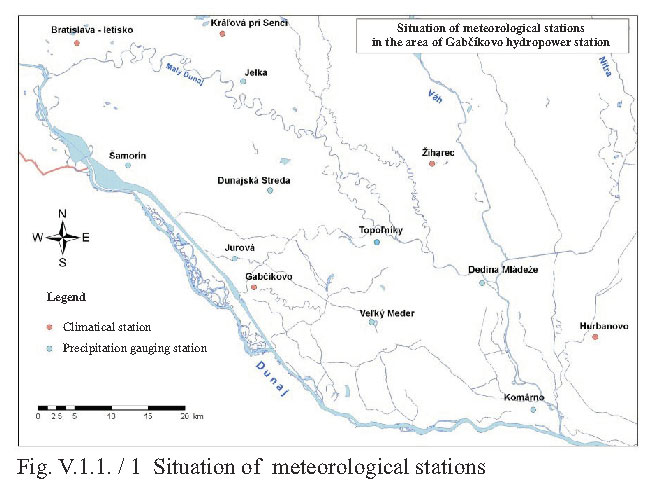
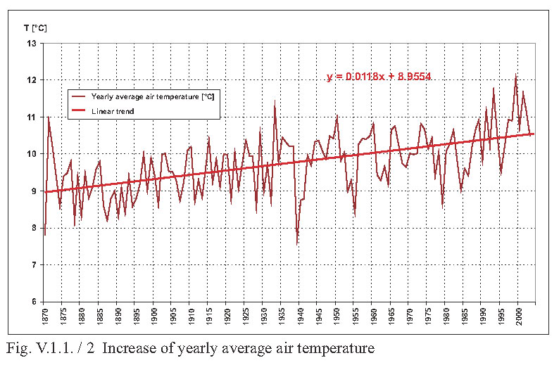
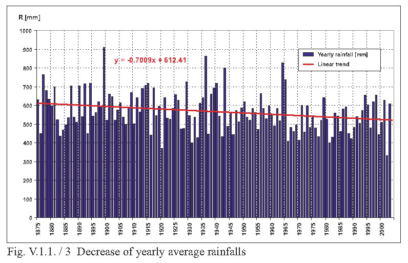
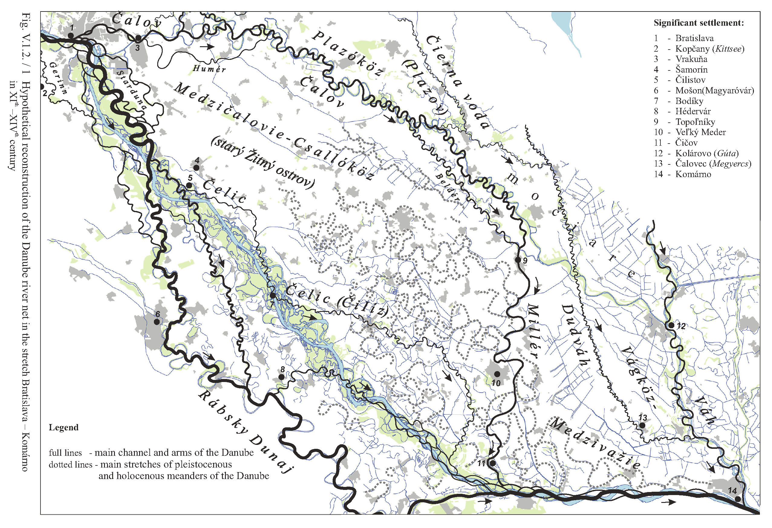
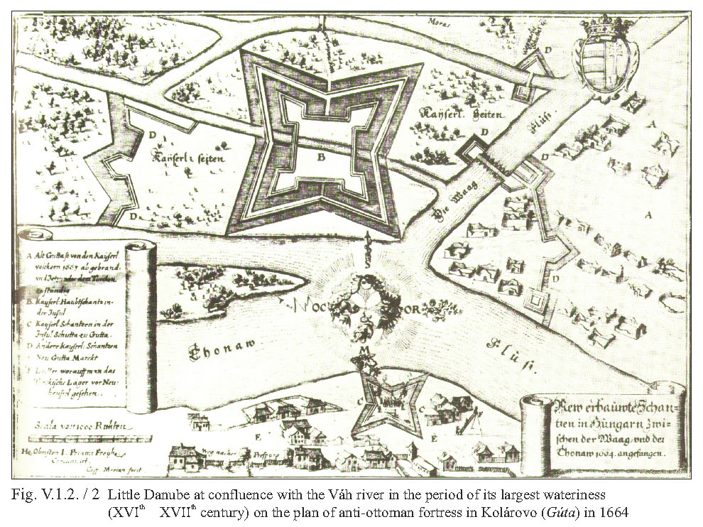
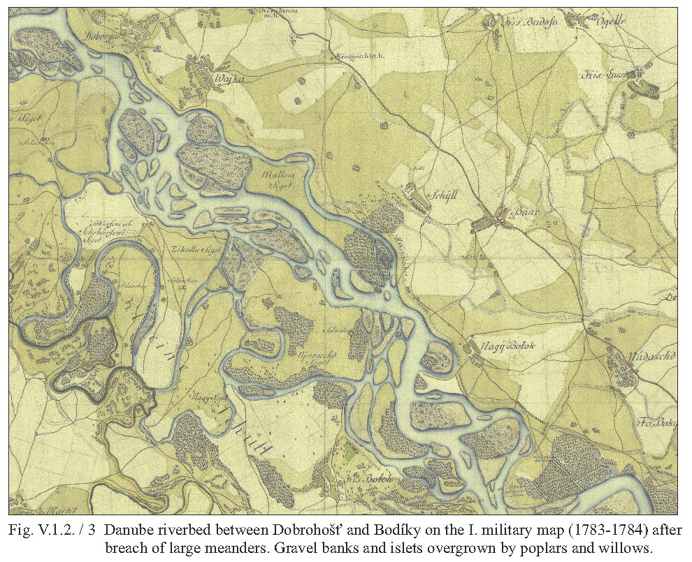
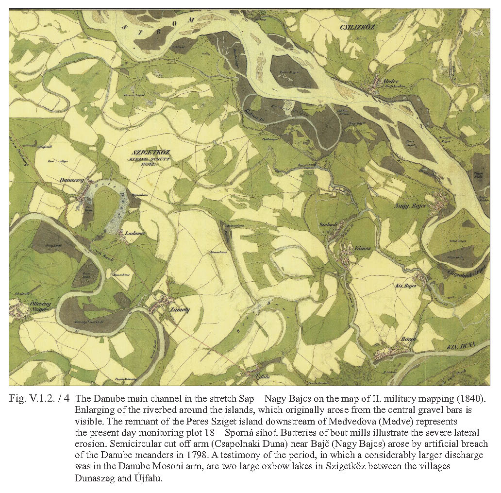
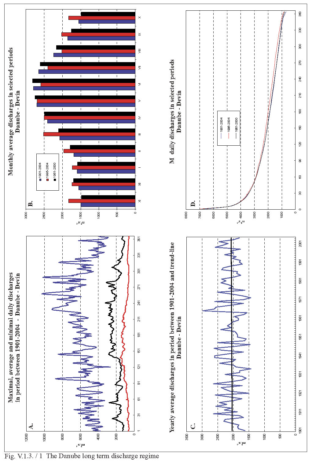
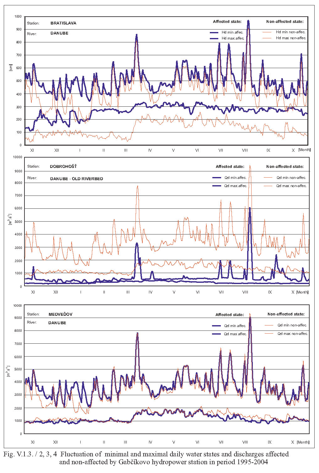
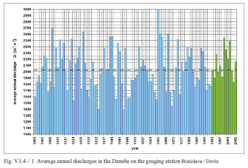
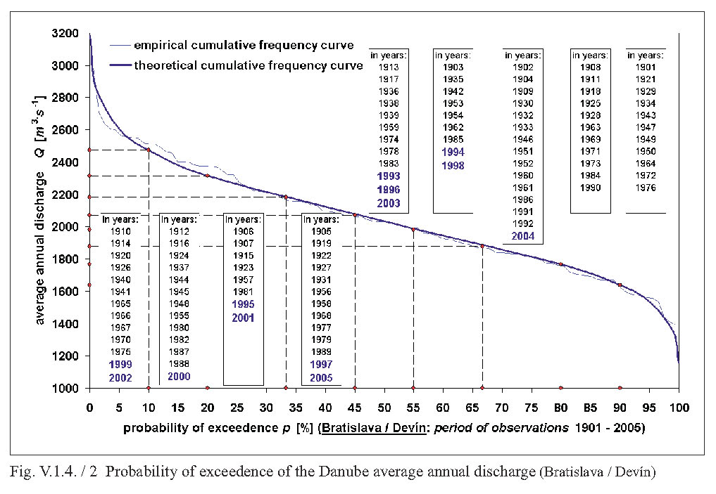
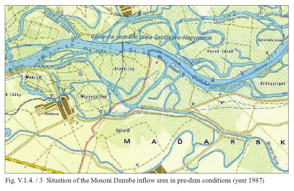
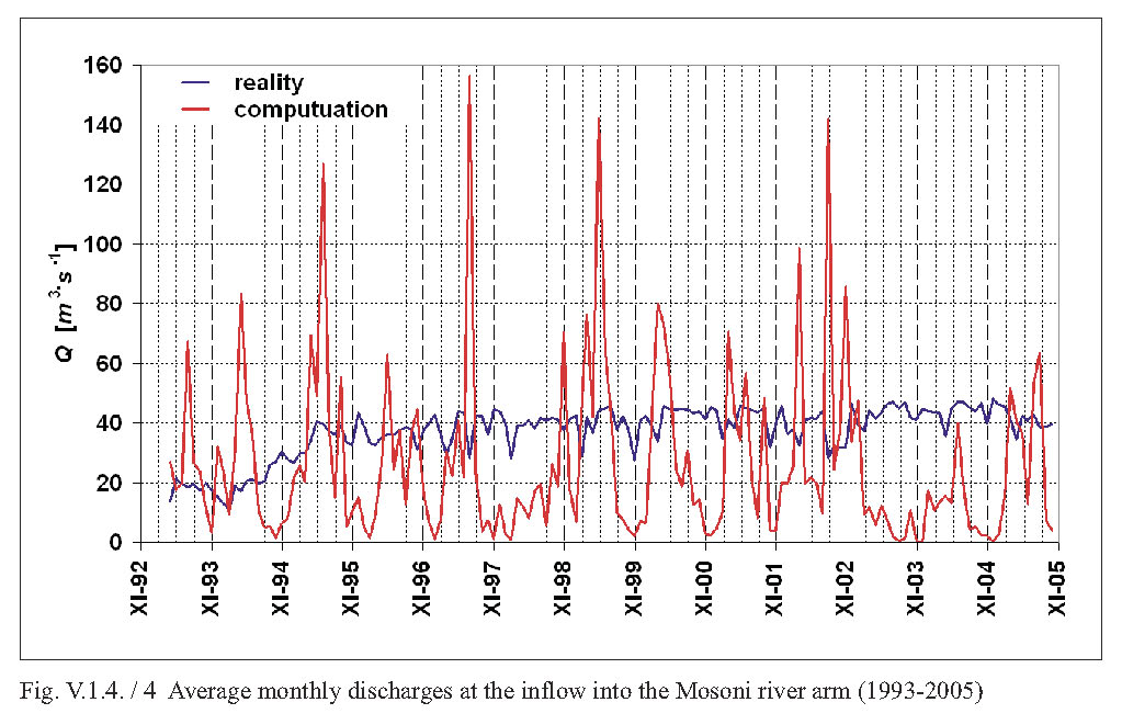
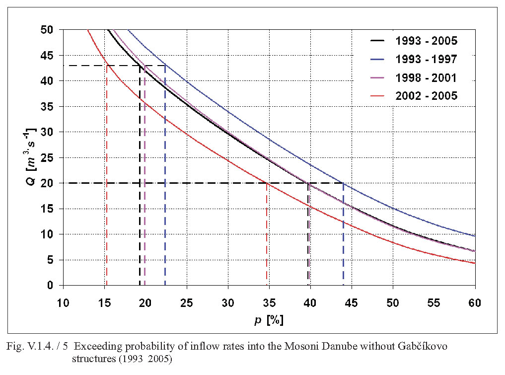
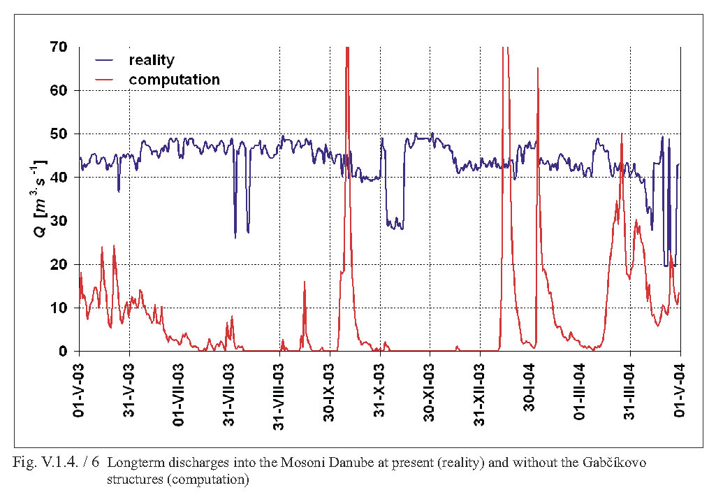
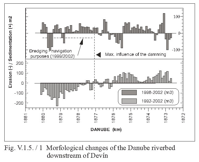
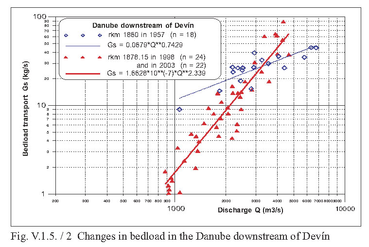
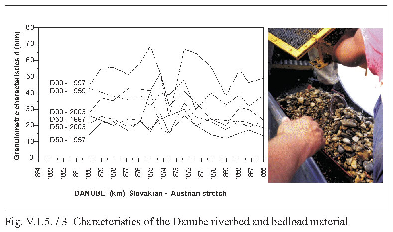
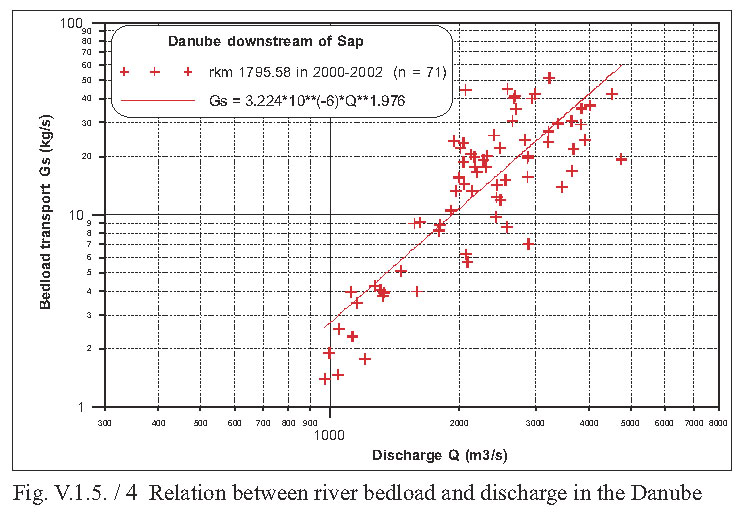
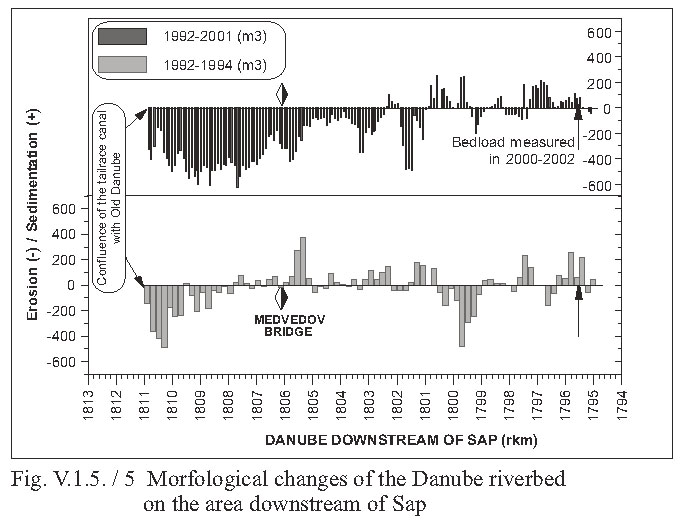
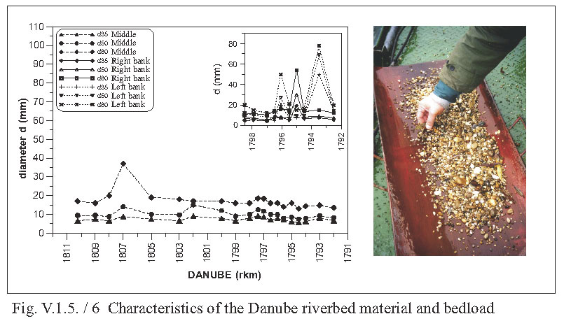
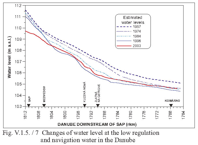
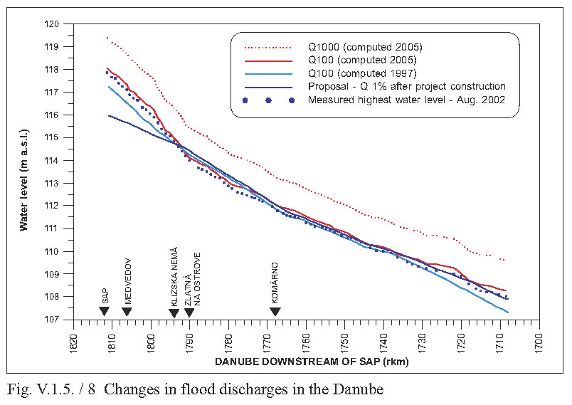