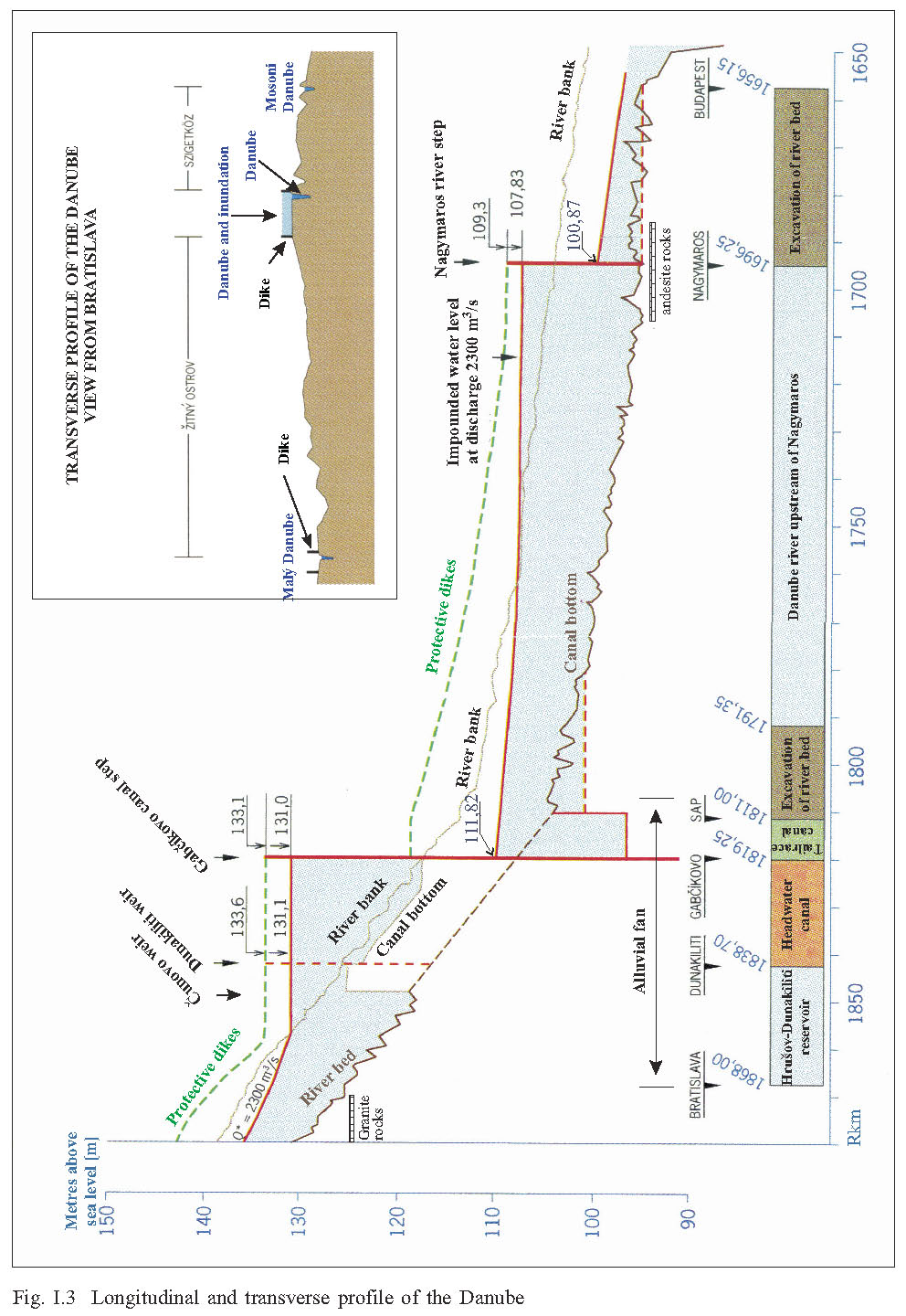
IV. Natural environment, processes and mankind impactIV.1 European union, exploitation and protection of natural environmentDominik Kocinger, Igor Mucha, IV.1.1 Global Climate Changes and Kyoto ProtocolThe aim of the Kyoto Protocol is a reduction of anthropogenic greenhouse gas emissions to a level that prevents dangerous anthropogenic interference with the climate system [14]. Greenhouse gasses referred to are: - Carbon dioxide (CO2) - Methane (CH4) - Nitrous Oxide (N2O) - Hydrofluorcarbons (HFCs) - Perfluorocarbons (PFCs) - Sulphur Hexafluoride (SF6) In the information society we tend to overreact to any change in the conditions of our life. However, scientific evidence indicates that climate change is happening. This is also the experience of the Commission of the European Communities in Communication from the Commission to the Council, the European Parliament, the European Economic and Social Committee and the Committee of the Regions in the document entitled “Winning the Battle Against Global Climate Changes”[1]. Over the 20th century, the global average temperature has risen by some 0.6 OC, in Europe a bit more. The overwhelming scientific consensus is that the cause is emissions of greenhouse gases from human activities. As a consequence, emissions and temperatures are expected to increase further in the coming decades. From the geological viewpoint it is nothing very unusual. After the end of glacial time, some 12000 years ago, sea levels had risen 120 m during the following 6000 years, on average 2 cm per year. Since 6000 years ago, a warm climate period followed, supporting a golden age of civilisation, agriculture, crafts and mankind’s development. In these past 6000 years, periodical changes in climate have existed. This is indicated by the so called little ice age, from approximately 1500 to 1850, portrayed for example by Flemish painters. According to geologists, after the present global warming, we should approach a new glacial time (see, for example, [15], page 43). In general, dry and wet years, cold and warm years, years with large and small discharges, floods and without floods, were changing in the past (see Pišút, in this issue). The minimal measured discharge in the Danube at Bratislava was 570 m3/s, maximal measured discharges were 10870 and 10400 m3/s (1899 and 1954). Historical estimated flood discharge in Vienna reached 14000 m3/s in 1501. We would like to stress that for the sustainable development of our societies and economies, it is wise to adapt our policy to mitigate climate changes, either global rise or decrease in the temperature, a wetting or drying climate, and the occurrence of floods, droughts, and other extreme events. Doing nothing is not a sensible option. What is awaiting us is described in the Commission of the European Communities Communication [1]. In the younger and later Bronze Age, there was a drier climate with lower discharges. It was possible to colonize lower lying areas with an altitude of only 134 m a.s.l. in the Danube floodplain. Later, in a part of Eneolit and in the earlier Iron Age, it was only possible to build up settlements in areas with a minimum altitude of 136-137 m a.s.l. (see Pišút in this issue). In Agriculture in central and northern Europe there are expected higher temperatures, extending growing seasons. Bad harvests could become more common due to an increase in the frequency of extreme weather events (droughts as in 2003, floods as in 2002, storms, hail), and pests and diseases. The same is valid for forestry (storms, fire, pests, e.g. 2004, 2005). In the southern parts of Europe, drops in yield of up to 30 % are expected. Lack of irrigation water could significantly increase this drop of yield (e.g. year 2004, 2005) in some regions. Experience from Spain, France, Italy and Portugal shows that the first measure is reducing water consumption for watering, washing and agriculture. In comparison with pre-dam conditions, installations and structures of the Gabčíkovo-Nagymaros hydropower stations project, completed at the Gabčíkovo step, make it possible to manage surface and groundwater, ground water recharge, the water supply of the Old Danube, Little Danube, Mosoni Danube river branch, the left and right Danube side inundation area, irrigation canals, and draining the surface and ground water, if necessary. For European agriculture this means some insurance to prevent large drops in yield because of extreme weather events and drought periods. Management possibilities with the surface and ground water regime is the only immediate measure available against sudden climatic events, mainly drought, floods, extreme temperatures, etc., in the municipal water supply, agriculture and forestry. In energy, the use of electric energy is likely to change both in terms of overall energy supply, and to meet peak consumption demands. The system of Gabčíkovo-Nagymaros hydropower plants was planned to supply continuous and peak electric energy (Gabčíkovo step in average 3000 GWh per annum, Nagymaros step in average 1000 GWh per annum). This means first of all production of renewable, clean, waste less, sustainable and secure European energy (Europe currently imports more than 50% of its energy needs) [2]. Clean – because hydro reduces the pollution in comparison with other sources. Sustainable, because it is renewable and does not contribute to the build up of greenhouse gases, and in addition, actually reduces the natural production of greenhouse gases (mainly methane) by changing previous stagnant water conditions in river branches. Secure – because they are sourced within Europe, not imported, and thus they reduce Europe dependency on events elsewhere in the world. In addition this production is waste free. The transport sector [7] uses 30% of EU energy consumption. It was predicted that CO2 emissions from EU transport in 2010 would be 39% higher than in 1990. In transport, [3] shows it is presently the root of 90% of the increase in CO2 emissions. A large improvement in navigation conditions on the Danube between Bratislava and Budapest, planned in connection with the construction of Gabčíkovo-Nagymaros system of locks, creates the possibility to shift the transport balance by promoting the less polluting and energy saving Danube waterway from the Baltic to the Black sea. This means adding a transport decrease in CO2 gas to the decrease caused by replacing fossil fuels with hydroelectric energy, into the bargain. However, this needs a better understanding and knowledge of the benefits and costs and investment needs in both hydroelectric energy and improving navigation conditions. (This means to produce hydroelectric energy and to save energy by using shipping transportation instead of road). However, this also needs EU policy support, to assess effects and effectiveness of different measures and policies, to increase the contribution of renewable and clean energy sources, and to help to fulfil the EU energy and climate change policy to meet the respective objectives [7]. Such an initiative is clearly stated as well in the Resolution of the European Industrial and Commerce Chamber [8]. What is not mentioned is, that one bottleneck on the Danube can considerable worsens the whole river transport effects and efficiency. From the health view point [1] improvement of the water regime (recovery – increase of ground water level after long term decrease, and through flowing water in the river branches) has a significant positive impact on gardens, town parks (Petržalka and Chorvátske river branch), inundation area, agricultural area, and improving the microclimate against future heat waves. Raising temperatures will bring risks of diseases like malaria (area of the Danube downstream of Bratislava is an endemic malaria area), dengue, schistosomiasis and various infectious intestinal diseases. Significant impacts on ecosystems [1] are likely when temperatures rise more than 1OC above pre-industrial levels. Some hotspots with high biodiversity and protected areas will begin to suffer, which will be intensified by a lack or decrease in water availability. A significant and general decrease of surface water level in the Danube and its river branches, and thus also a ground water level decrease on the broad inundation area, has been observed on the Danube from Bratislava to Budapest. A continuation of such processes combined with a rise of temperatures would increase the impact on ecosystems. By an impoundment of the Danube, and in that manner watering of the river arms, increasing the ground water level, soil moisture, and in addition, by a simulation of floods, it is possible not only to reduce the negative impacts but also to improve conditions for ecosystems. Water resources, ground water recharges and water quality are expected to worsen. Water self-purification processes, supported by flowing water in more natural conditions in river branches, in eupotamal (for example proposed new main riverbed) and in through-flowing reservoirs, together with higher water levels, could help to significantly reduce the adverse impacts of the global warming, including growth of algae (eutrophication). After the 2002 damaging floods along the Danube and Elbe rivers, protection against floods received greater awareness and involvement of the Commission of the European Communities [4], [5]. In communication [5] there is written, „Many Member States are already taking flood protection measures, but concerted and coordinated action at the level of the European Union would bring a considerable added value and improve the overall level of flood protection”. This means the European Commission is giving flood protection higher priority. The need of higher priority was further confirmed in this spring (2006). Doing nothing is not a sensible option. An example of coordinated action could be the area of the Danube between Bratislava and Budapest, where there are specific flood protection conditions. The Danube is flowing on the top of an alluvial fan consisting of very thick, coarse and high permeable gravel (Fig. I.3). Flood discharge in the Danube generally increases downstream until Bratislava [9]. Crucial impulses to construct Gabčíkovo – Nagymaros System of Hydropower Plants and Locks were the catastrophic floods on the Danube in 1954 and 1965, when large areas on both the Hungarian and Slovak sides of the Danube were flooded. The main integrated floodwater management measures to be taken into consideration by the planning of the Gabčíkovo-Nagymaros structures were:
Results of the 2002 summer flood peak discharge along the Danube are in the following table. Table: Culmination of water levels and flow rates during the flood event in August 2002
X – flow rate of the Danube confluents between Bratislava-Devin and Budapest was approximately 300 – 400 m3/s. Peak flow in Budapest was lower in comparison with Bratislava-Devín by app. 2500 m3/s. New experience was the spring flood in 2006. Melting of extreme large snow masses caused high discharges of the Danube tributaries (Váh rive 1500 m3/s, Hron, Ipeľ 500 m3/s each). Maximal flood discharge was therefore in Budapest much higher as in Bratislava. High snow masses are still laying in mountainous areas. It is lesson to revaluate Nagymaros project from its all water management functions (flood protection, navigation, energy production, revitalization of the nature, water supply, development of infrastructure and others). However, flood protection is never absolute; only a certain level of protection can be reached [4]. The concept of residual risk should therefore be taken into consideration. That means clearly define the design level of protection to which the flood control structures might be reliable defended, or local conditions that might weaken it, and determine flood risks in the protected floodplain basin [4]. Build, maintain and rehabilitate, where necessary, dams, flood ways, bypassing channels, dykes and other flood-control works, hydraulic structures and other water construction works in order to ensure that they are safe and provide a sufficient level of flood protection [4]. Dam safety, the operation of dams during flood events and the legal framework concerning the operation of dams during flood events should be taken into consideration.
IV.1.2. Exploitation of the Danube natural resourcesDIRECTIVE 2000/60/EC is establishing a framework for Community actions in the field of water policy. As set out in Article 174 of the Treaty, the Community policy on the environment is to pursue the objectives of preserving, protecting and improving the quality of the environment, in prudent and rational utilisation of natural resources [18 (11, 12)] based on available scientific and technical data, environmental conditions and the economic and social development. This includes integration of protection and sustainable management of water into other Community policy areas [18 (16)]. In this case it means: - flood protection, - energy, - transport, - agriculture, - improvement of the quality of the environment, - tourism, - public health, - and other specific policy areas as for example water supply, decrease of anthropogenic greenhouse gas emissions, and others. The same objectives are the objectives of the Treaty 1977 [19] and the objectives of the Judgment of the International Court of Justice [20]. Directive 2004/101/EC [6] (amending Directive 2003/87/EC) provides guidance for the environmental evaluation of hydroelectric power generation as a potential source of renewable and waste-less electric energy. According to DIRECTIVE 2004/101/EC [6 (14)], criteria and guidelines that are relevant to considering whether hydroelectric power production projects have negative environmental or social impacts have been identified by the World Commission on Dams in its November 2000 Report “Dams and Development – A New Framework for Decision-Making” [21], by the OECD and by the World Bank. In chapter 8, Strategic Priority 3, Addressing Existing Dams, there are ideas about comprehensive monitoring and the evaluation process, optimisation of benefits, and the effectiveness of environmental mitigation measures. A range of monitoring based measures to enhance and restore the Danube inundation ecosystems is published [22, 23] and further described in the following chapters. According to DECISION 884/2004/EC [17], taking into account the objectives for the development of a trans-European transport network, the priorities (related to the Danube section Bratislava – Budapest, covered also by the international Treaty 1977 [19] and confirmed by the Judgement of the International Court of Justice [20] ) shall be: - elimination of bottlenecks, especially in their cross-border sections and cross natural barriers (e.g. river fords), - promotion of long-distance, short sea and inland shipping, - integration of safety and environmental concerns in the design and implementation of the trans-European transport network When transport projects are planed and carried out [16] environmental protection must be taken into account by the Member States by carrying out, pursuant to Council Directive 85/337/EEC, environmental impact assessment of projects of common interest which are to be implemented and by applying Council Directive 79/409/EEC on the conservation of wild birds (amended by Regulation (EC) No 807/2003) and 92/43/EEC.
|
|
Changes or redistribution in the flow rates and water distribution |
|
- among the Old Danube, derivation canal, left side and right side inundation area and their river branches including Mosoni and Little Danube |
|
- creation of artificial reservoir – through flowing lake – in the place of previous river and a part of inundation area. |
|
Changes in surface water regime |
|
- changes in flow velocities in surface water bodies, |
|
- changes in water levels in water bodies |
|
- changes in water level fluctuation in water bodies |
|
- changes (general enlargement) of water bodies areas and water bodies banks |
|
- changes in surface water quality and river bed composition |
|
Changes in ground water regime |
|
- changes in ground water levels and its fluctuation |
|
- changes in ground water level depth |
|
- changes in soil moisture |
|
- impact on microclimate |
|
- changes in ground water quality |
|
Changes in biota |
|
- changes and redistribution of aquatic flora and fauna |
|
- changes and redistribution of terrestrial flora and fauna |
|
- changes in soil properties |
|
Changes in land use |
|
- improvement of flood protection |
|
- production of renewable and waste less energy |
|
- improvement of navigation conditions |
|
- improvement of water management possibilities |
|
- impact on agriculture |
|
- impact on forestry |
|
- impact on tourism and recreation |
|
- impact on water supply |
|
Other aspects, which should be taken into consideration |
|
- climate changes |
|
- long term pre project natural and manmade changes (e.g. meandering, flood protection, navigation) |
|
- present man made changes (e.g. roads, sport activities, irrigation, drainage, etc.) |
|
- agricultural and forestry practices and activities, fishery |
|
- comparison with areas not influenced by the project |
REFERENCES
|
[1] |
European Communities, 2005: Communication from the Commission to the Council, the European Parliament, the European Economic and Social Committee and the Committee of the Regions, “Winning the Battle Against Global Climate Changes”, Brussels, 9.2.2005. |
|
[2] |
European Commission, Directorate-General for Energy and Transport, 2004: Electricity from renewable energy sources, Encouraging green electricity in Europe. |
|
[3] |
European Commission, 2002: Directorate-General for Energy and Transport, Presentation. |
|
[4] |
Water Directors of the European Union, (Sept. 25th, 2003): Best Practices on flood prevention, protection and mitigation. |
|
[5] |
Commission of the European Communities, 12.07.2004: Communication from the Commission to the Council, the European Parliament, the European Economic and Social Committee and the Committee of the Regions, Flood risk management, Flood Prevention, protection and mitigation. |
|
[6] |
DIRECTIVE 2004/101/EC of the European Parliament and of the Council of 27 October 2004 amending Directive 2003/87/EC establishing a scheme for greenhouse gas emission allowance trading within the Community, in respect of the Kyoto Protocol’s project mechanisms. |
|
[7] |
Decision No 1230/2003 of the European Parliament and of the Council of 26 June 2003 adopting a multiannual programme for action in the field of energy “Intelligent Energy – Europe” Global Work Programme for the years 2003-2006, 15 October 2003. |
|
[8] |
UNION europäischer Industrie- und Handelskammern Rhein, Rhone, Donau Alpen, 2005: Resolution Engpässe im Donaukorridor unverzüglich beseitigen. Linz, 16 September 2005. |
|
[9] |
Lászlóffy, W., (sc. ed.), 1965: Az 1954. évi Dunai árvíznek szentelt szám, Vízügyi Közlemények az Országos Vízügyi Főigazgatóság kiadványa 1955. év 1-2. füzet. |
|
[10] |
Report on the activity in 1995 of the Hungarian-Slovak Joint Monitoring System Defined in the Intergovernmental Agreement, 19 April 1995, submitted by the Hungarian side as the Hungarian National Annual Report. |
|
[11] |
Joint Annual Report of environmental monitoring in 1995 according to the “Agreement between the Government of the Slovak Republic and the Government of Hungary about Certain Temporary Measures and Discharges to the Danube and Mosoni Danube”, signed April 19, 1995, submitted by the Slovak and Hungarian sides including Minutes from meetings of 29 May 1995, 29 November 1995 and 25 March 1996. |
|
[12] |
National Annual Report of environmental monitoring on Slovak Territory for 1995. |
|
[13] |
Észak-Dunántúli Vízügyi Igazgatóság, 1995: Fenékküszöbbel történő vízpótlás hatásai (Impact on the water supply by means of the underwater weir, 1995, West-Danube Water-Management Directorate). |
|
[14] |
Council Decision (2002/358/CE) of 25 April 2002 concerning the approval, on behalf of the European Community, of the Kyoto Protocol to the UN Framework Convention on Climate Change and the joint fulfilment of commitments thereunder. |
|
[15] |
Michalík, J., Reháková, D., Kováč, M., Soták, J., Baráth, I., 1999: Geológia stratigrafických sekvencií, VEDA, SAV Bratislava, 234 pp. |
|
[16] |
DIRECTIVE 2003/87/EC of the European Parliament and of the Council of 13 October 2003 establishing a scheme for greenhouse gas emission allowance trading within the Community and amending Council Directive 96/61/EC. |
|
[17] |
DECISION 884/2004/EC of the European Parliament and of the Council of 29 April 2004 amending Decision No 1692/96/EC on Community guidelines for the development of the trans-European transport network. |
|
[18] |
DIRECTIVE 2000/60/EC of the European Parliament and of the Council of 23 October 2000 establishing a framework for Community action in the field of water policy. |
|
[19] |
Treaty Between the Hungarian People’s Republic and Czechoslovak Socialist Republic Concerning the Construction and Operation of the Gabčíkovo-Nagymaros system of Locks (United Nations – Treaty Series, Vol. 1109, I-17134). |
|
[20] |
International Court of Justice, Year 1997, 25 September 1997, Case Concerning the Gabčíkovo-Nagymaros Project (Hungary/Slovakia). |
|
[21] |
Dams and Development, a new framework for decision-making, the report of the World Commission on Dams, November 2000, EARTHSCAN, 404 pp. |
|
[22] |
Mucha, I., (sc.ed.) 2004: Vodné dielo Gabčíkovo a prírodné prostredie - Súhrnné spracovanie výsledkov slovenského a maďarského monitoringu v oblasti vplyvu VD Gabčíkovo. (Hydroelectric Power Project Gabčíkovo and natural environment – summary of the Slovak – Hungarian monitoring in the area of the Gabčíkovo barrage structures.) Plenipotentiary of the Slovak Republic for Construction and Operation of the Gabčíkovo-Nagymaros Hydropower Project. Bratislava, Slovakia. 413 pp. |
|
[23] |
Lisický, M., J., Mucha I., (sc. eds.), 2003: Optimalization of the Water Regime in the Danube River Branch System in the Stretch Dobrohošť-Sap from the viewpoint of Natural Environment, Faculty of Natural Sciences, Comenius University, Bratislava, and the Plenipotentiary of the Slovak Republic for Construction and Operation of the Gabčíkovo-Nagymaros Hydropower Project. Bratislava, Slovakia. 205 pp. |
|
[24] |
Commission of the European Communities, Czech and Slovak Federative Republic, Republic of Hungary, 1992: Working Group of Independent Experts on Variant C of the Gabčíkovo-Nagymaros Project, Working Group Report, Budapest, Nov. 23, 1992. |
|
[25] |
Commission of the European Communities, Czech and Slovak Federative Republic, Republic of Hungary, 1992: Fact Finding Mission on Variant C of the Gabčíkovo-Nagymaros Project, MISSION REPORT, October 31, 1992, Bratislava. |
|
[26] |
Dosztányi, I., (ed.), 1988: Gabčíkovo Nagymaros Environment and river dams, AQUA KIADÓ, Budapest. |
|
[27] |
Decision of government of the Republic of Hungary 1139/2004 (XII.11) concerning the principles of river and land rehabilitation in the area of Gabčíkovo-Nagymaros project impacts, and of the position to be held in connection with Hungarian – Slovak negotiations. |
|
[28] |
Agreement 1995: Agreement between the Government of the Slovak Republic and the Government of Hungary about Certain Temporary Measures and Discharges to the Danube and Mosoni Danube, signed on April 19, 1995 |
|
[29] |
The treaty establishing the European Community, Official Journal of the European Communities, C 325/33 |