III.2.4 PART 3: Ground Water RegimeThe impact of the temporary technical measures and discharges into the Danube and Mosoni branch of the Danube, realised according to the Agreement, and the impact of the water supply on the ground water regime and ground water levels in the hydrological year 2003 was monitored by 265 observation wells on the Slovak and the Hungarian territories. These monitoring objects are situated in the area of Žitný ostrov and in the Szigetköz region. The situation of the observation networks on both sides is shown in Fig. III.21. Evaluation of ground water level data in 2003 was done by the Parties themselves and is given in the respective National Annual Reports. The evaluation in this report was prepared according to the jointly constructed ground water level equipotential lines. The equipotential lines were constructed for comparison of the ground water levels in the influenced area in the current year and the ground water levels before construction of the bottom weir and introducing a water supply into the river branches on the Hungarian side. Joint evaluation of the ground water regime Considering the course of water levels in the Danube River during the hydrological year 2003 it can be stated that it was an atypical year (Fig. III.13 and Fig. III.14). In general, the highest ground water levels were recorded in the winter period as a consequence of extremely water rich months, while in the vegetation period a continuous decrease of natural water level was observed. However, where water was supplied – in the Slovak and Hungarian river branch system and along the Mosoni Danube – the ground water level was artificially raised in comparison to the natural water level. This evaluation is focused on the area influenced by the river branch water supply. The ground water level position depends mainly on the water level fluctuation in the Danube, water level position in the reservoir, and water level fluctuation in river branches. For computing the ground water level differences three hydrological situations were chosen in the period before and after introducing the water supply. The hydrologic situations were selected to characterize the low, average and high flow rate conditions in the Danube, corresponding to flow rates approximately 1000, 2000 and 3000 m3s-1. However, due to the atypical flow rate regime of the Danube in 2003, the chosen hydrological situations are not fully comparable. The climatic conditions and evapotranspiration at low and high flow rates were different. Table 6: Dates and the corresponding flow rates in the Danube at Bratislava-Devín
* Low winter discharge into the Old Danube riverbed and river branches, including water redirection into the Mosoni Danube branch. Low flow rate period in hydrological year 2003 occurred in the second half of the vegetation period, while normally it occurs during the winter period. For evaluation purposes the hydrological situation at the end of a period with low flow rates in August 2003 was chosen. The average flow rate period was chosen in the first decade of June, in a comparable hydrological situation as the period chosen in 1993. The high flow rate period was chosen at the beginning of December 2002. Maps of equipotential lines were jointly constructed for the selected dates using the measured ground water levels, Fig. III.22, Fig. III.23, Fig. III.24. In wells where the water level is measured once a week, the ground water levels for the selected dates were computed by linear interpolation. In all other wells the daily average values were used. The altitudes of the ground water levels are given on maps for each observation object used for the equipotential line construction. For constructing equipotential lines, computed surface water level data in the Danube was used as well. These levels were computed by a calibrated model, using river morphology and measured water level data. The other surface water levels (in river branches) were not used for constructing of the equipotential lines. The constructed equipotential lines represent general ground water levels and flow direction, and do not show the local influences of the channels or river branch systems. Differences between ground water levels for selected comparable hydrological situations are expressed in Fig. III. 25, Fig. III.26, Fig. III.27. The evaluation is mainly focused on the area influenced by the technical measures and discharges according to the intergovernmental Agreement and by the water supply realized on the Hungarian side. In this sense the inundation and the flood-protected area on the Hungarian side, and partly the inundation area on the Slovak side, represent the influenced area. Comparing the low water hydrological situations (approximately 1000 m3s-1) in periods before and after realizing the technical measures and releasing discharges according to the Agreement (2003 versus 1993) it can be stated that, in consequence of an increased water level in the Danube old riverbed and water supply into the right side river branch system and into the Mosoni Danube, on the whole part of the influenced area a significant increase of ground water levels occurred, both on the flood-protected area and the inundation area as well Fig. III.25. In the upper and middle part of the Szigetköz area, significantly higher ground water levels were created at low flow rate conditions. A significant increase in the ground water level also occurred along the Mosoni Danube. In the lower part of the Szigetköz, around the Bagoméri river branch system, where the water supply is still not solved, the ground water levels were lower than the ground water levels in 1993. Lower ground water levels were recorded at the whole lower part of the Žitný ostrov as well, due to the extremely low flow rate in the Danube in the vegetation period. However, the most significant decrease of ground water levels occurred along the tailrace channel, downstream the confluence of the tailrace channel and the Danube old riverbed. The riverbed erosion influences this region. In general, the increase of ground water levels is about 0.5-1.2 m in comparison to ground water levels in 1993. This occurs mainly in the area affected by the water supply realised on the Hungarian side. There is an increase of ground water levels in the inundation area on the Slovak side as well, which is evoked by the water supply on the Slovak side, however this is independent on the measures according to the Agreement. The ground water level fluctuation during the year in the upper and middle part of the Szigetköz region was around 0.5-1.5 m. In the lower part of the Szigetköz it changed between 1.5-3 m. Due to extremely low flow rates in the Danube, the ground water levels in observed wells approached their lowest recorded levels. On the left side of the reservoir a decrease in the ground water levels can be observed. This is connected with a lower water level in the reservoir compared to the 1993, and a decrease in permeability of the reservoir bottom as well. However, the ground water levels at present are much higher than before constructing the dam. The decrease in the ground water levels on the reservoir left side is significantly less in comparison to the situation before the two big floods on the Danube in 2002. After the floods in hydrological year 2002, the permeability of the reservoir bottom significantly increased and the ground water levels around the reservoir almost returned to their position after filling the reservoir. The decrease of ground water levels downstream of the Gabčíkovo hydropower station is partially caused by a deepening of the tailrace canal and erosion of the Danube riverbed downstream of the confluence (at the mouthing of the Bagoméri river branch). However, the decrease in 2003 is more significantly due to extremely low flow rates in the Danube in the vegetation period. Comparing the ground water levels in the period before realising the technical measures and after increasing the discharges into the Danube according to the Agreement, and after introducing the water supply on the Hungarian side, at average flow rate conditions in the Danube (approximately 2000 m3s-1), the result is similar to that at low water conditions. A significant increase in the ground water levels occurred in both the upper and middle part of the Szigetköz area. The ground water level increase is about 0.3-1 m (Fig. III.26). The most significant ground water level increase occurs in the upper and middle part of the Hungarian inundation area, where it reaches 0.5-1 m. Compared to 1993, the ground water levels along the Danube in the lower part of the Szigetköz (Bagoméri branch) were slightly lower and were influenced by the low flow rates in the Danube, however on the rest of the area they remained unchanged. The ground water levels decrease is caused by riverbed erosion. On the Slovak territory no impact from the technical measures according to the Agreement appears. Higher ground water levels in the left side inundation area reflect the different water supply regime in the river branch system in 1993 and 2003. A ground water levels decrease can be observed around the left side of the reservoir. This results from a lower water level in the reservoir than in 1993, and a decrease in the permeability of the reservoir bottom as well, but in general the ground water levels are higher than before damming the Danube. On a large part of the Slovak side there were no changes in ground water levels observed. When comparing the high flow rate conditions in the Danube (approximately 3000 m3s-1 on 02. December 2002 - winter water management envisaged in Agreement) with the period before realising the measures according to the Agreement (before 1993), a decrease in the ground water levels can be seen along the Danube, both in the Szigetköz and Žitný ostrov regions (Fig. III.27). Decrease in the inundation area reaches 0.3-0.8 m. This is caused by the difference in the discharges released to the Old Danube in 1993 (1020 m3s-1) and in 2003 (392 m3s-1) and due to comparatively different water management situations (low winter discharge regime into inundation and into the Old Danube). On most of the area no change is documented. Changes in the area around the reservoir on the Slovak side are related to the lower water level in the reservoir and a decrease in the permeability of the reservoir bottom. Conclusions In spite of unfavourable hydrometeorological conditions in 2003 (low flow rates in the Danube during the whole vegetation period, and insufficient precipitation) no significant changes were observed in the area affected by the water supply in comparison to the previous years. The water supply into the right side river branch system plays an important role in influencing ground water levels over the Szigetköz region. As a result of the measures realised according to the intergovernmental Agreement a significant increase in the ground water levels occurred for low and average flow rates in the Danube. However, no significant changes in the upper and middle part of the Szigetköz region, and a decrease of ground water levels along the Danube are characteristic for the high flow rate conditions. The monitoring results highlights the necessity of increasing the ground water level in the lower part of the inundation area on both sides. The necessary ground water level increase in the lower part of the Ásványi river branch system, in the Bagoméri river branch systems, and the Istragov island on the Slovak side could be solved by an extension of the water supply system to these areas or by measures applied in the Old Danube upstream of the confluence with the tailrace channel. Such measures can improve the situation. An increase of ground water levels in the strip along the Old Danube on both sides could be ensured only by increasing water levels in the Danube by measures realised in the riverbed. The most simple, quickly realisable measure seems to be the solution applied at Dunakiliti at rkm 1843, realised according to the “Agreement”.
III.2.5 PART 4: Ground Water QualityHungarian territory The subject of the joint ground water quality monitoring on the Hungarian side consists of 22 wells. 16 observation wells are situated in the upper part of the gravel sediments, and 6 wells are used for drinking water supply. Samples were taken 4 times during the year. In 2003 no samples were taken from the Darnózseli I drinking water well. Dissolved oxygen measurements in ground water quality monitoring wells were done as well. Water quality monitoring wells are shown in Fig. III.28. In compliance with point 1 of the Recommendations of the Joint Annual Report in 1999 long-term evaluation of the ground water quality starting in 1992 has been elaborated in the 2003 National Annual Report. The detailed evaluations, tables and graphs of ground water quality data are part of the Hungarian National Report as well. The ground water quality in the selected four observation wells on the Hungarian side was as follows. Well No. 9327, locality: Dunakiliti. On the basis of long-term data the seasonal, periodical variation of water quality was markedly observed in the ground water observation well, the water of which had low salt content, similar to the Danube water. Periodicity appears mainly in changes of water temperature, dissolved oxygen, conductivity, pH and nitrate ion concentrations. Along with this a slight increase of sodium and chloride concentration was recorded. No substantial change occurred in the organic contamination, phosphate ion concentration or in the content of nitrogen forms in comparison to the previous year. Iron in was detected in a concentration below the ground water quality limits, while the manganese concentration, which increased in comparison to the previous year, exceeded these limits in the second half of the year. Well No. 9413, locality: Sérfenyősziget. In the year 2003 the meteorological conditions did not affect the water temperature significantly. Seasonal fluctuation was monitored in pH values and sodium, iron and manganese contents. The conductivity values, which refer to the salt concentration in the water, fluctuated more significantly; on the basis of average values a decreasing tendency can be seen. The content of potassium, magnesium and chloride was below ground water quality limits, with a further decreasing tendency. Calcium in 2003 was present in a lower concentration, however it exceeded the ground water quality limits. The concentration of organic matter showed a slight increase. From among the nitrogen forms, limit values were measured for nitrite ion on one occasion, while the ammonium ion and nitrate ion concentrations, as well as the organic contamination remained below the limits. Among nitrates, a limited fluctuation and decreasing tendency was observed. The iron content slightly increased and exceeded the ground water quality limit on one occasion. The manganese content fluctuated seasonally and consistently exceeded the limit value. Well No. 9430, locality: Kisbodak. The temperature water, with a moderate salt content, was lower than in the previous year; the fluctuation was of a lower rate and it did not follow changes of air temperature. The previous trend of decreasing salt content stopped; values were stable in comparison to the previous year. An increase was observed in organic contamination and in phosphate concentration. Values of nitrite and nitrate ions were similar to values of the previous year, with maximum observed in spring. There was a decrease recorded of ammonia ion and sulphates. Considering the drinking water use, only the ammonia ion content could be objectionable. The iron and manganese concentrations in the water were high. The iron content fluctuated significantly throughout the year, while the manganese content showed a seasonal fluctuation. Well No. 9456, locality: Ásványráró. The conductivity values of this water, with a stable, slightly seasonally fluctuating water temperature and medium salt content, did not change significantly from the previous year. The organic material content was below the ground water quality limit values and presented a slight seasonal fluctuation; no significant change occurred in values compared to the previous year. From among the nitrogen forms, the ammonia ion concentration exceeded the limit value, with a maximum in the summer period. The slight increasing tendency stopped. Nitrite and nitrate contamination is not typical. The iron and manganese concentrations demonstrated a seasonal fluctuation over the limits. Slovak territory For purposes of the Slovak-Hungarian monitoring, data of the Western Slovakia’s Waterworks Enterprise (ZVS), the Waterworks Enterprise Bratislava (BVS), Slovak Hydrometeorological Institute (SHMÚ) and Ground Water Consulting Ltd. were used. The wells of the Waterworks Enterprises are used for drinking water supply; the other wells are observation wells. The evaluation for every well included in the joint monitoring, as in the previous years, was done for a period of eleven years (1.10.1992-31.10.2003) in the National Annual Report. The evaluation in this report is focused mainly on the ground water quality in waterworks, which are more representative because of their continuous exploitation. Since April 1, 2004, a new Ordinance No. 151/2004 of the Slovak Ministry for Public Health was set, which completely transposed the EU Directive No. 98/83/EC from November 3, 1998, describing the water quality limits for human consumption. Where the Slovak national standard prescribes other values, the notice “SK” is in the Table 7. Short evaluation of the ground water quality in monitoring objects included in the data exchange In comparison to the previous year, there were no significant changes in the parameters observed during hydrological year 2003. A long-term evaluation was done in the Slovak National Annual Report in 2003 for an eleven-year period, comparing the data from all monitored wells with the agreed limit values for ground water quality. Ground water quality at wells used for drinking water purposes has been very stable over the long term and satisfies the agreed ground water quality limits. The only exceptions are the waterworks at Bodíky (No. 485), where manganese concentrations 17 times, and ammonia concentration once, exceeded the limit value during the whole observation period, and the waterworks at Rusovce (No. 102), where sulphate concentration once exceeded the limit value (1992). (See table “Exceeding Standard limits in ground water quality parameters” in the Graphical Appendix of the Slovak National Annual Report in 2003.) The ground water quality in observation wells is more influenced by local impacts. From the table “Exceeding Standard limits in ground water quality parameters” in the Graphical Appendix of the Slovak National Annual Report in 2003 results, the agreed limit of ammonia concentration was more frequently exceeded at object No. 899, while occasionally at objects 87, 329, 872 and 888. For nitrite concentration, the limit values were exceeded more frequently at object No. 170, while occasionally at wells No. 234 and 872. In the case of manganese, the limit value was exceeded more frequently at object No. 899, occasionally at objects No. 170 and 3. The iron concentrations overrun the limits at objects No. 170 and 872, occasionally at objects No. 262, 265 and 87. Only sporadically do values exceeding limit concentrations occur for magnesium, CODMn and chlorides. Concentrations of all other quality components satisfy the limits for ground water quality. Ground water quality evaluation at waterworks for the drinking water supply Right side of the Danube (Waterworks at Bratislava No.–907, at Rusovce–102, at Čunovo–2559) The waterworks water quality at Rusovce and Čunovo is very similar. Damming the Danube had a great influence on the ground water quality due to the changed infiltration conditions and changed ground water flow direction, especially at the waterworks Rusovce. After the damming, the concentration of cations (Na, Ca, Mg) and anions (Cl, SO4, HCO3) significantly decreased, which resulted in permanent decrease in conductivity. A similar process, but to a lesser extent, was observed at the waterworks Čunovo, mainly in case of sodium, chlorides and sulphates. At Rusovce there is a slight increasing tendency of pH values. In the period of 1998-1999, the ground water quality stabilised, and now the cations and anions fluctuate in a narrow range; for calcium and magnesium there is a slight increase observed, while for sulphates and hydrocarbons the decrease continued. At both waterworks the nitrate concentrations, as well as the organic contamination, expressed by CODMn and TOC, decreased and then got stabilised. The situation is different at waterworks No. 907, Bratislava. Values of respective parameters fluctuate a lot during the year, except the pH value. This waterworks is situated near the Danube and concentrations of the observed parameters follow the fluctuations of these parameters in the Danube. Based on the measured values, it can be stated that an increase of magnesium concentration, and a decrease of sulphates, manganese, phosphates and organic contamination has occurred. Left side of the Danube (Waterworks at: Kalinkovo No.–116, Šamorín–105, Dobrohošť–467, Bodíky–485, Gabčíkovo–103) The ground water quality at waterworks situated on the left side of the Danube was not influenced to the same extent as the waterworks on the right side. The ground water quality at waterworks No. 116 at Kalinkovo and No. 105 at Šamorín is similar. Some differences (at Kalinkovo a slight increase, at Šamorín a slight decrease) exist in calcium, magnesium and hydrocarbonate concentrations and conductivity values (wider range at Kalinkovo). The manganese concentrations at Kalinkovo fluctuate around 0.2-0.3 mgl-1. At both waterworks the concentrations of nitrates had decreased, however since 2001 there has been a slight increase. Sulphate concentrations decrease, at both waterworks. The concentrations of silicates slightly increased, with increase since 2002 more evident. The CODMn values in 2002-2003 slightly decreased at both waterworks. TOC at Kalinkovo increases, at Šamorín the increase of TOC stopped in 2000 and the concentrations have begun to decrease. In comparison to the previous period, the average water temperature 2003 increased by 1°C at Kalinkovo waterworks in the period 2001-. The Gabčíkovo waterworks is situated in the area drained by the tailrace canal and the water comes to the wells from the inland area. The conductivity, content of dissolved solids, chlorides, sulphates, sodium, potassium and nitrates have slightly increased in the long term. This fact shows that the amount of ground water coming from the inland area has gradually increased. Concentrations of silicates are higher in comparison to waterworks Kalinkovo and Šamorín, moreover since 2002 there is an additional slight increase. The oxygen content is low, but the nitrate concentration slightly increased and the TOC and CODMn values decreased to 1 mgl-1. The oxidative capacity for organic carbon oxidation slightly improved. The iron content is below the detection limit, however the manganese content rarely exceeds the given limit. The ground water quality at waterworks No. 467 – Vojka and No. 485 – Bodíky is strongly influenced by the local conditions. Although the waterworks are close to each other, it can be stated that tendencies in ground water quality parameters are different: a decrease of conductivity, calcium, manganese and sulphate concentrations at Bodíky waterworks; an increase of conductivity, calcium, manganese, sulphate and hydrocarbonate concentrations at Vojka waterworks. At waterworks Bodíky the ammonia concentrations fluctuate in a wide range from 0.05 to 0.57 mgl-1, however a slight decrease in 2002-2003 could be observed. The manganese concentrations fluctuate mainly from 0.2 to 0.8 mgl-1. Nitrate concentrations decreased at both waterworks during the whole monitoring period, however since 2001 a slight increase has been observed. Concentrations of CODMn and TOC slightly decreased at both waterworks during the last two years. Concentrations of silicates slightly increased during the observed period at both waterworks. Conclusions The basic physical and chemical parameters, cations, anions and oxygen, satisfy the agreed ground water quality limits at all monitoring objects. The nutrient content satisfies the agreed limits in the long term as well, except the nitrates at object No. 170 during the period 1994-2000, while in 2001-2003 the situation got better, and the ammonia content, particularly at object No. 899. The iron and manganese contents satisfy the agreed limits at most of the monitored objects, however the manganese content frequently exceeds its limit at objects No. 116, 485, 899 and 262, and the iron content exceeded the limit at objects 170 and 872, occasionally at objects No. 262 and 234. Summarizing the results of the long-term water quality observations of 16 groundwater quality observation wells on the Hungarian side, it can be stated that the water base of Szigetköz is typically characterised by a higher iron and manganese content. The manganese content was continuously over the groundwater quality limit at 12 wells, while the iron concentration exceeded the limit value at 9 wells. In 2003 further changes in ground water quality could be observed at certain wells, since the content of components, like nitrogen forms and organic material, changed from well to well, presumably indicating contamination of agricultural origin and waste water. However, their content was generally lower or it did not change in comparison to the previous year. Ground water quality at some places reflect an integrated effect of the transformations that occurred in the region, in which the ground water flow directions affected by the Szigetköz water supply changed. The ground water quality of the drinking water producing wells could be characterised by a high degree of stability. The drinking water wells in the Győr region show a small scale of manganese and ammonia contamination. The salt content, iron and manganese concentrations were higher in wells at the Győr-Révfalu water source, than in wells at Győr-Szőgye, which were pumped from larger depths. The ground water quality in drinking water wells, occasionally after pre-treatment, is suitable for drinking water supply. Limits for drinking water quality used for evaluation in the frame of Joint monitoring are given in Tab. 7. Table 7: Ground water quality limits for drinking water.
EU – European standard, SK – Slovak standard, H– Hungarian standard IV – indicating value RV – recommended value LV – limit value HLV – highest limit value III.2.6 PART 5: Soil Moisture MonitoringData collection methods The Slovak side measured soil moisture by a neutron probe. The measurements were performed either down to a prescribed depth or to the depth of ground water level. The Hungarian side carried out the measurements with a capacity probe to the prescribed depth. Soil moisture is expressed by the total water content in volume percentage recorded in 10 cm depth intervals. Measurements on the Slovak side were performed on 12 forest monitoring areas, 5 biological monitoring areas and 3 agricultural areas. Measurements on the Hungarian side were performed on 9 forest monitoring areas and 5 agricultural areas. The location of observation objects is shown in Fig. III.29. Data presentation methods Both Parties present soil moisture in figures showing the average soil moisture content in volume percentage for the depth interval from 0 to 100 cm and from 110 to 200 cm. A small difference can occur in the Hungarian data, where the value for a depth interval under 110 cm can represent the average value for the rest of the total measured depth (the average value can be calculated from less than 10 measured values). On colour figures the soil moisture time distribution for the whole measured depth is presented. Presentation of the whole set of measured data is given in the Slovak and Hungarian National Annual Reports. Evaluation of results on the Hungarian side The soil moisture measurements on the Hungarian side in 2003 continued at forestry monitoring sites in the floodplain area as well as at agricultural monitoring sites in the flood-protected area. The moisture conditions of soils are essentially influenced by the rainfall conditions, by the soil layer thickness and composition as well as by the ground water level. The observed soil moisture values in 2003 were significantly influenced by unfavourable rainfall distribution. The total amount of rainfall at the beginning of the year was low and reached only 40-60% of the long term average. The soil saturation by water at the beginning of the vegetation period reached 70-80%. A higher amounts of rainfall occurred in May, June and July, however it was not sufficient and there were also major differences in the spatial distribution. The soil moisture continuously decreased and minimal values were reached in August and September when the rainfall conditions were very unfavourable. Partial replenishment of the soil moisture in the upper part of the soil layer was induced by precipitation in October, however the following two months were characterized by insufficient rainfall again. The soil moisture in the Szigetköz region was adversely influenced by the atypical flow rate regime in the Danube as well. While in the winter period (November 2002- January 2003) several significant flood waves occurred, no flood or higher discharge occurred during the vegetation period. Moreover, from the middle of June till the middle of September there were unusually low flow rates in the Danube. The average ground water level in the Upper part of Szigetköz lagged behind the average ground water level in 2002 by 7-25 cm, while in the middle part of Szigetköz it lagged behind the average water level in 2002 by 32-78 cm. For all soil moisture monitoring points on forestry areas it was characteristic that in the soil layers down to 1 m depth the maximum and average values of the soil moisture content were lower in comparison with the previous year. The minimal values were comparable or only slightly lower compared to the previous year, because periods with a critical lack of moisture occurred in both years. The highest average soil moisture contents in the layer down to 1 m depth on most observed sites were recorded at the first measurement cycle in the year 2003. From then the soil moisture content continuously decreased and the lowest values usually occurred at the end of vegetation period. Similar situation arose in the layer below 1 m depth. However on monitoring sites influenced by the water supply, the groundwater in varying depth moisturized the soil - monitoring sites No. 9355, 9994, 9995 (Fig. III.30, Fig. III.32). The positive influence of the water supply on monitoring sites No. 9498, 9996 and 9997, which are situated closer to the Old Danube riverbed, was limited because of the drainage effect. The drainage effect prevails at monitoring site No. 9972. Monitoring site No. 9452 (Fig. III.31), in the middle part of Szigetköz, is situated near a water supply river branch and it was continuously moisturized by the ground water, however the ground water level was lower in comparison with the previous year, Fig.III.31. Monitoring site No. 9998 is situated below the water supply system and the ground water level is influenced only by the water level fluctuation in Old Danube. So, due to the unfavourable hydrological conditions, the ground water level fluctuated in a much lower rank than in the previous year. The soil moisture at monitoring sites on the flood protected areas No. 2630 and 2653 in hydrological year 2003 was influenced by the precipitation only, due to the depth of the ground water level. Maximum soil moisture values were recorded at the beginning of measurement in 2003. At monitoring site 2630, situated near the Dunaremete gauging station on the Danube, a continuous decrease of soil moisture values was observed. Although the ground water level at monitoring site No. 2653 is situated deep, the soil moisture values both in the layer down to 1 m depth, and below, showed only very slight decreases. Monitoring sites No. 2605 and 9443 are situated in areas with a thick covering layer. The ground water moisturised the base of soil layer throughout the whole year, however the rainfall influences the upper layer. Monitoring site No. 7920 is situated in the area where the drainage effect strongly influences the ground water level. The surface water level is influenced by the backwater effect. Due to low water levels in the Danube, the ground water only moderately moisturised the thick covering layer. Evaluation of results on the Slovak side According to the soil moisture observations at monitoring sites situated in the agricultural area (sites No. 2716, 2717 (Fig. III.33), 2718) the soil moisture content during the whole observed period remained unchanged. Only at monitoring site No. 2718 did the soil moisture content decrease significantly due to unfavourable climatic conditions. The position and fluctuation of ground water levels remained unchanged as well. In the year 2003, the ground water level at monitoring site No. 2716 fluctuated in depths of 2.2-4 m, at site No. 2717 in depths of 2-3.8 m and at site No. 2718 in depths of 1.6-2.8 m. The fluctuation of soil moisture content in the depth interval from 0 to 1 m mostly depends on climatic conditions. In the depth from 1 to 2 m, the soil moisture fluctuation, except monitoring area No. 2716, is partly influenced by the ground water level. The soil moisture content in the depth to 1 m mostly fluctuated in the range from 7 to 18 % at monitoring site No. 2716, and in the range from 19 to 32 % at monitoring sites No. 2717 and 2718. In the depth between 1 and 2 m, the soil moisture content mainly varied from 15 to 20 % at monitoring site No. 2716, in the range from 30 to 35 % at monitoring site No. 2717, and in the range from 12 to 26 % at monitoring site No.2718. Situation in the inundation area is more complex. Changes of the soil moisture depend mainly on the location of the monitoring site in respect to the Danube, in respect to the river branch water supply, and on the soil profile thickness. The soil moisture is along with the ground water level and precipitation, highly dependent on natural or artificial floods. In hydrological year 2003 there were neither natural nor artificial floods in the area. During the winter period the moisture in the soil profiles reached values comparable to previous years. Hydrological and climatic conditions were rather favourable, although the precipitation amount in February was very low. However, the precipitation in the following two months (March and April 2003) was low again. From the beginning of the vegetation period the soil moisture was decreasing. The next three months (May, June and July 2003) were richer in precipitation, however the amount of water was not sufficient to supply the soil and the soil moisture decrease continued. August and September 2003 were dry and warm. The soil moisture reached values close to the lowest ones recorded during the whole monitoring period. Soil moisture was not supplied from the ground water either, because of unusually low flow rates in the Danube during the whole vegetation period. These unfavourable hydrological and climatic conditions were partially reduced on areas were the water supply is applied. However, an artificial flooding of the inundation area would have been the best solution. In the inundation area around Dobrohošť and Bodíky villages, the thickness of the soil profile is low, similarly to the Hungarian side at monitoring sites No. 2703 (Fig. III.35), 2764, 2763, 2762 and 2761. The ground water level in hydrological year 2003 fluctuated only in the gravel layer. The ground water level at site No. 2703 fluctuated from 4 to 5 m, at sites No. 2764, 2763, 2762 and 2761 it ranged from 2.5-4.5 m. The average values of the soil moisture content, both on top, a depth to 1 m, and below, significantly fluctuated and they were highly dependent on the climatic conditions Fig. III.35. Maximal average soil moisture contents occurred in January 2003. During the vegetation period the soil moisture content, both in the layer down to 1 m depth and the lower layer, significantly decreased. Minimal values occurred at the end of October 2003. The thickness of the soil profile in the middle part of the inundation area is higher. In general the ground water regime in this region is influenced by the water supply of the river branch system, introduced in May 1993. Moreover, the natural or artificial floods have a high influence on the ground water level. The ground water level usually fluctuates above the boundary between the soil profile and gravel layers - monitoring sites No. 2704, 2705, 2758, 2759 (Fig. III.36), 2760 (Fig. III.34), The lack of precipitation during the dry period in 2003 resulted in a continuous decrease of the soil moisture content, both in the upper and lower parts of the soil layer. The ground water supplied the soil profile only at a depth below 2 m. No natural or artificial floods occurred in 2003, so the upper soil profiles were not supplied from the ground water. The maximal values of soil moisture content were reached in January 2003, minimal values mostly occurred at the end of the year. In the lower part of the inundation area, downstream of the confluence of the river branch system and the Danube (monitoring sites No. 2706 (Fig. III.37), 2756, 2755), the ground water level usually fluctuates around the boundary between the soil profile and the gravel layer. However, in 2003, due to low flow rates in the Danube, the ground water level dropped by 1 m in comparison to the previous year and did not supply the soil profile. The average values of the soil moisture significantly fluctuated, and are strongly dependent on the ground water level fluctuation. The minimum and maximum values are related to the minimum and maximum ground water levels respectively. In 2003 low water levels in the Danube negatively influenced the soil moisture and at the end of the vegetation period soil moisture reached the lowest values ever recorded, Fig. III.37. Minimal values of soil moisture in the layer down to 1 m depth occurred at the end of September and in the layer between 1 and 2 m in depth at the end of 2003. The soil moisture contents at monitoring sites No. 2707, 3804, 3805, located in the inundation below the confluence of the tailrace canal and the Old Danube, are highly influenced by the flow rate regime in the Danube. The maximum values in the year 2003, in the depths down to 1 m and between 1 and 2 m, occurred in January, while the minimum values occurred at the end of the vegetation period. The ground water level at monitoring site No. 2707 and 3804 fluctuated mostly in the depth 2.5-4.5 m, on the other site in the depth 0-2.8 m. These monitoring areas were negatively influenced by the low flow rates in the Danube similarly to the monitoring areas located in the area influenced by the Gabčíkovo structures.
III.2.7 PART 6: Forest MonitoringBoth countries examine the growth and the health state of forest stands in a similar way. Monitoring sites on the Slovak and Hungarian territories, included in the joint monitoring, are shown on Fig. III.38. Both the Slovak and Hungarian Parties in the present report evaluate the development of the basic growth parameters, weekly girth growth and the health state of trees in forest stands for the year 2003. The Hungarian Party in its National Annual Report performed an analysis of aerial photos taken in 2002 and 1991 with an accent on changes in the extent of forest area on the right side of the river. The atypical flow rate regime of the Danube and unfavourable climatic conditions influenced the development of the tree stands in 2003. A detailed review of abiotic conditions is given at the beginning of Part 7- Monitoring of Biota. The Slovak territory The forest monitoring on the Slovak side is carried out on monitoring areas situated in the inundation area Fig. III.38, where the most productive, rapidly growing wetland forest communities occur. These communities have high demand on water and have relatively high resistance to pests and pathogens. Table 8: List of the forest monitoring areas and species on the Slovak side
Monitoring areas No. 2683-2690 are situated in the region with regulated ground water level (between the intake structure at Dobrohošť and confluence of the Bačianske river arm and the Old Danube). Specific conditions between the individual cross-weirs in the river branch system are created, depending on the ground water level and thickness of the soil profile. Presence of unfavourable moisture conditions was confirmed in the region of Dobrohošť, upstream of the cross-weir B (monitoring site No. 2690), due to the shallow soil layer. Although the soil moisture depends mostly on climatic conditions, an increase of soil moisture values are observed during the realisation of artificial floods. The development of forest communities at monitoring sites No. 2689 and 2688 is affected by the specific conditions in the strip along the Old Danube, where the drainage effect strongly appears. The ground water level usually fluctuates in the gravel layer during the greater part of the vegetation period, and in 2003 it fluctuated in the gravel layer only. Forrest communities under such conditions depend on precipitation. The precipitation ensures favourable moisture conditions for development of wetland forest thanks to the excellent retention ability of soils. However, in case of repetitive dry periods, as occurred in 2003, damage to the forest communities can be expected without a water level increase in the Danube. This is confirmed by the not fully successful reforestation of the area No. 2689. In other parts of the region with regulated ground water, favourable water supply to forest stands can be confirmed. The positive impact of artificial or natural floods can be shown as well. An earlier increase of the discharge into the left side river branch system could further improve the moisture situation at the beginning of the vegetation period. The best time, from the forest development point of view, seems to be the beginning of March, before the vegetation period and start of intensive forest transpiration. During the vegetation period, the immediate evaluation of soil moisture measurements could help in operationally changing the discharge and water level regime in the river branches, or it could even signal the need for artificial flooding of the area, in time of act. The region with unregulated ground water is situated downstream from the mouth of the Bačianske river arm to the confluence of the Old Danube and the tailrace channel. Monitoring areas No. 2681, 4219, and 2682 represent this region. Moisture conditions in this region are mostly favourable. The soil moisture is generally supplied from the ground water. The ground water level is more favourable during higher flow rates in the Danube, and full saturation of soils occurs than. This phenomenon, thanks to the excellent retention ability of the soil, has a long-time effect. The unfavourable hydrological conditions in 2003 (the long lasting average and low water period in the Danube) demonstrated the need to supply water to this region. The moisture conditions were further deteriorated by the long lasting dry and warm period in the summer of 2003. The monitoring areas No. 3802 and 3803 are situated in the region downstream of the confluence of the derivation canal and the Old Danube riverbed. Direct impacts of the Gabčíkovo hydropower structures were not proven in this region, the moisture conditions of biotopes were very favourable. Two strong natural floods, at the beginning and at the end of the vegetation period in 2002, were the main factors influencing the development of vegetation. A long lasting dry and warm period and simultaneous low flow rates in the Danube were characteristic for the vegetation period in 2003. This was reflected in the growth and the health state of forest stands on most of observed areas. The growth of poplars “I-214” and “Robusta” in the region with regulated ground water level has been continuously adequate; trees growth corresponds to the curve of the absolute quality class of 36-40, although they are behind their growth culmination. The girth growth of trees was relatively even throughout the whole vegetation period, which points out the absence of natural or artificial flooding of the inundation area in 2003. A more frequent occurrence of zero weekly increments on several poplar stands, which were recorded during the previous year, was not repeated. The gradual spreading of the newly cultivated clone “Pannonia” was registered in the inundation area. It is being planted on areas after the original monitoring stands are cut. Evaluation of some of these young stands will start in the following year. According to the evaluation of the health state of this clone, no significant deterioration has been documented in the region. A decrease of resistance to leaf damagers was registered on every present clone in 2003, due to the dry and warm vegetation period. Spreading of fungicidal illnesses was restricted. On the other side, the climatic conditions evoked premature defoliation in several regions – particularly the region at Dobrohošť (area No. 2690) and the strip along the Old Danube (areas No. 2688, 2689) where the drainage effect occurs strongly. The older stands don’t actually show damage signs due to water insufficiency; however, this phenomenon will probably cause problems for reforestation of these stands. This is already indicated by not fully successful reforestation at monitoring area No. 2689. The growth and the health state of poplar “Robusta” in the region with unregulated ground water level, upstream of the confluence of the Old Danube and the tail race channel, was adequate as well. This region is characterised by the positive impact of the backwater effect and the regular presence of floods; however, the long lasting period of low flow rates in the Danube in 2003 influenced this region negatively. This is demonstrated by the unsuccessful reforestation of monitoring area No. 2681 by cultivated white willow, which emphasizes the need to solving the water supply of this region. The Hungarian side The forest monitoring areas on the Hungarian side, except monitoring area No. 9452 at Hédervár, are situated in the inundation area Fig. III.38. The forestry observations in 2003 included measuring the wood yield and the increase in girth of selected individuals, as well as the tree health state observation. Table 9: List of the forest monitoring areas and tree species on the Hungarian side
According to the wood yield measurements in 2003, poplar stands “I-214” and “Pannonia”, which occur in stands ideal for poplars, were able to reach much higher growth rate than correspond to the relevant forest yield charts. However, in line with the growth data since diverting the Danube, the changed environmental conditions slightly affected the older stands with outstanding capabilities and the middle-aged stands enjoying good habitat, but sensitively affected the stands situated on locations unsuitable for poplars. In the case of willows, the growth rate in monitoring areas with younger stands can be still considered as favourable. However, taking into account the slower growth rate of willows, it is unfavourable that the growth rate of 13-14 year old stands has decreased, although the growth of these stands is supposed to culminate between 20-25 years. In general, conditions for willow cultivation became noticeably worse at their original planting places. According to the weekly girth increments, the growth of poplar clones has been slow in recent years, although their yearly height growth was suitable. Similarly to previous years, two peaks were registered in the girth growth of tree on Hungarian side, which were followed by a small one at the end of the vegetation period. The first peak occurred at the end of May, which was followed by stagnation during June. This corresponds to a dry period with high temperatures and soil moisture decreases. The second peak is bounded to the beginning of July, when a higher amount of rainfall moisturized the soils. The growth of willows for the entire year was similar to the previous period, however its rate was lower than the expected values. The changed hydrological conditions influenced, in addition, the health state of forest stands. The impact of diverting the Danube is mostly present on the original willow stands. The health state of willows shows a remarkable deterioration in the region upstream of the Dunasziget and Kisbodak villages in 2003. With the current water supply, and due to the high calcium content in soils and the high location of willow stands, along with missing floods, most of sites became not suitable for willow growth. Few willows along the Danube riverbank has dried up in previous years, but the state of the remaining individuals have become better in recent years. The health state of poplars showed improvement in the year 2003; bark infection of poplars was rare, premature defoliation was minimal. The herb layer is a good indicator of biotope moisture conditions as well. In spite of the drought in 2003 the undergrowth reached higher values than the previous year, when two big floods influenced the development of vegetation. The species composition changed in favour of nettle, which appeared everywhere in large volume and reduced the spreading of other species. Spreading of the invasive Impatiens glandulifera was lower. The comparison of aerial surveys of the inundation area performed in 1991 and 2002 was done within the framework of analysing and evaluating the health condition of the alluvial woods of Szigetköz. According to this comparison the wooded area of Szigetköz grew. This increase reflects the net change of extension of the bush-willow strips along the Old Danube and the decrease of the forest area in the inundation area. Concerning the evaluation of the health state, the Hungarian side has the opinion that under the present conditions, neither the automated picture processing used in 2002, nor a visual one as, tried out in 2003, is suitable for unambiguous appraisal of the health condition changes of the region’s forests. According to the Hungarian side, the use of field investigations seems to remain the most important method for the estimating health conditions.
III.2.8 PART 7: Biological MonitoringThe biological monitoring of aquatic and terrestrial fauna is carried out on six complex monitoring areas on the Slovak side. On these areas the phytocoenological observations were realised as well, which record the spring and the summer aspect of plant communities. Aquatic macrophytes observation was restarted in 1999. The monitoring continued by the method of phytocoenological relevés of Braun-Blanquet until 2002, as it was introduced at start of the monitoring. In 2003, due to unification of observation methods, the Slovak side began to use the Kohler index method in the frame of aquatic macrophytes monitoring. The same groups of fauna and flora, agreed in the frame of joint monitoring, are monitored at 31 monitoring sites on the Hungarian side Fig. III.39. There continue to be differences in some monitoring methods on both sides henceforth (e.g. on the Hungarian side the similarity index and the ecological analysis of terrestrial plant communities is not evaluated; reed communities on the Slovak side are not observed in such detail as on the Hungarian side; the monitoring of Ephemeroptera, Trichoptera and Odonata on the Slovak side is based on aquatic larvae observation, while the Hungarian side it relies on observations of images), however, further unification is ongoing. Abiotic conditions, which influence the growth and development of plant and animal communities in the area on both sides of the Danube can be characterised as follows in 2003:
Phytocoenology The left side river branch system The changes of biota on monitoring area No. 2600 are caused by a gradual long-term drying up of the locality, which had already been observed since the seventies of the twentieth century. The observed phytocoenoses developed relatively favourably, which could be explained by the increase of soil moisture after two strong floods in 2002. A similar phenomenon was registered at the beginning of the vegetation period in 2003. The development of every three layers of phytocoenoses was relatively favourable. Neither premature defoliation nor mosaic loosening of the herb layer coverage occurred in the summer period. The extremely dry weather was visible on drying of nettle, but only in August. Only the increase of species diversity and the rising number of invasive species reflect the tendency of a gradual change of community towards a more xerophilous one. Monitoring areas No. 2603 and 2604 are situated downstream of the intake structure to left side river branch system, thanks to which the moisture conditions have not changed significantly after damming the Danube and a high water level can be kept in the river branches too. Some change was recorded in the flood regime of the region. From monitoring area No. 2603, attention should also be aimed at changes caused by the drainage effect of the Old Danube. Phytocoenological monitoring on monitoring area No. 2603 (TMP 9A) was restarted in 2002 in the five-year-old cultivated poplar stand, after an interruption in the period 1998-2001 due to a cut out. The gradual development of the stand in the second year was shown by the increase of the tree layer coverage and the decrease of ruderal and nitrophilous species in the summer aspect. The decrease of species numbers and coverage of the herb layer in the summer period was caused by the long-term drought. The plant communities at monitoring area No. 2604 are stable. Life form changes after floods in 2002 and the fluctuation of several ecological factors, which are not caused by hydropower station operation, testify to the dynamic development of the softwood phytocoenoses. Monitoring areas No. 2608 and 2609 are situated in a region where the backwater effect upstream the confluence of the tailrace channel and the Old Danube significantly decreases the impact of water diversion. Although the situation in this area is relatively stable (particularly at monitoring area No. 2609), the some improvement of the water regime should be realised. In the case of long lasting low and average flow rates in the Danube, the area becomes vulnerable. Premature defoliation of willows and fading and drying of plant species was registered during the extremely dry summer period in 2003, accompanied by high temperatures and low ground water level due to the long lasting low flow rates. On monitoring area No. 2609, a well-preserved willow stand is present, typical for softwoods. Dry weather conditions did not affect the phytocoenoses in 2003. However, the spring dominance of Aster lanceolatus, accompanied by the simultaneous retreat of protected species Leucojum aestivum, is an atypical phenomenon. Reference monitoring area No. 2612 is situated downstream the confluence of the tailrace channel and the Old Danube, where the direct impact of the Gabčíkovo waterworks is insignificant. In spite of unfavourable moisture conditions in 2003, the development of transitive floodplain forest was relatively favourable. A strong spreading of nitrophilous species was registered in the evaluated year, because of a new sediment layer rich in organic matter, brought by the two floods during the previous year. The right side river branch system The evaluation of plant and reed communities monitoring on the Hungarian side is based on data of the summer aspect. According to the obtained results, changes of vegetation in the observed area are slow and not significant. Interannual differences in meteorological conditions do not alter the vegetation to such an extent that could be detectable by field investigation methods used in the frame of joint monitoring. In 2003, according to the phytocoenological studies, a slightly significant increase in species richness was recorded, however the rise from the point of view of coverage values was not significant. Average values of leaf area were lower in comparison to the previous year, while no clear tendency appeared in this variable for the reed stands. The vegetation of oxbow lakes had regenerated where water supply created sufficiently high water level. Since the water level in Mosoni Danube was artificially kept stable the ground water table depth stabilised, thus no vegetation change appeared that could be attributed to the diversion of the Danube. A number of semi-natural willow stands grow at the banks of the Old Danube; however, hardwood plantations on the drying floodplain have replaced several willow forests. Field observations indicate a high regeneration potential for wetland vegetation. Artificially watered wetlands are rapidly and spontaneously colonized, or re-colonized, by characteristic wetland species. The bank of Lipót Lake is a good example for this. This indicates that there would be a quick regeneration for floodplain vegetation if the water recharge for an oxbow lake, for a river branch, or even for a complete tributary system could be provided artificially by distributing sufficient water in the area. The influences of a high water table and temporary flooding of vegetation are more pronounced if these occur from April to September, than during the rest of the year. Terrestrial molluscs The left side river branch system The process of drying out in the area of monitoring site No. 2600, which was recorded in previous decades, speeded up after diverting the Danube. The terrestrial mollusc’s community had stabilized at a medium degradation level of the original community of dryer softwoods type. A temporary decrease in further hygrophilous species was registered during the dry summer. In the year 2002, the monitoring of terrestrial malakocoenose in the original monitoring site “9A” of monitoring area No. 2603 was restarted. It had been temporarily moved to the monitoring site “9B”, due to the forest stand cut out. A high degree of similarity was noted between the two sub-sites and the composition of malakocoenoses in 2002 was comparable to its composition before the damming. During the dry year 2003, the malakocoenose develop an atypical structure, with the dominance of two ecologically different species (semi-steppe and hygrophilous forest species). The gradual development of the tree layer will lead to a decrease of microclimate fluctuations in the next few years, which should be reflected in the stabilisation of the malakocoenose. The permanent presence of a natural wetland community of terrestrial molluscs can be observed on monitoring site No. 2604. Polyhygrophilous and hygrophilous forest species remain dominant. The drought in 2003 was reflected in the decrease of abundance only. According to the monitoring results in 2003, the malakocoenoses on monitoring site No. 2608 are moving towards the xerophilous type. The expected decrease of non-original species after the flood in August 2002 was not confirmed, moreover a further decrease of hygrophilous species was registered due to unfavourable moisture conditions in 2003. The high species diversity, atypical for wetland communities, was maintained as well. A hydro-technical water supply solution for this part of the inundation seems to be necessary. The water regime changes in the area of monitoring site No. 2609, after diverting the Danube, are minimal thanks to the backwater effect. The unfavourable moisture conditions in 2003 were shown by the irregular occurrence of several polyhygrophilous species, and by a significant decrease of abundance, mainly during the summer sampling. Penetration of xenocenous (alien) species was not registered. The hydrological regime of the area downstream the confluence of the Old Danube and the tailrace channel was not changed. The malakocoenose of monitoring site No. 2612 consist of species with various ecological demands, from polyhygrophilous to eurytopic species. The mixing of communities from diversified surroundings during regular floods created wide species diversity. The lack of moisture in 2003 was shown in a decrease of species number and their abundance during the summer. The right side river branch system The terrestrial molluscs community in the inundation area, as well as in the flood-protected area, is intact. The decrease in the number of individuals of the terrestrial molluscs in the year 2003 is an unfavourable phenomenon. On the other hand, the proliferation of Lithoglyphus naticoides, the occurrence of Unio crassus and the regular presence of Palidilhia oshanovae should be regarded as a favourable trend of change. The settlement of the species Planorbis carinatus and Gyraulus riparius in the side branches was recorded. Aquatic macrophytes The Danube Two Hungarian monitoring sites are situated (No. 2 and 7) in the Old Danube. The old riverbed had not been providing favourable conditions for the development of macrophyte communities before it’s damming. Monitoring area No. 2 is in the main riverbed downstream of the bottom weir, where the flow rate prevents the creation of macrophyte communities. Monitoring site No. 7 is separated from the Old Danube by shoreline vegetation of Salicetum triandrae and Scirpo-Phragmitetum. This part of the water area was isolated and it had a macrophyte community rich in species in the last years. The left side river branch system The state of the macrophyte community at monitoring area No. 2603 has been determined by the water supply through the intake structure since 1993. Macrophytes in deep arms with flowing water mainly occur along the line structures, where they are protected from the strong current. Strong floods washed out their stands in 2002, and their regeneration was not registered in 2003. Only one isolated submerged species was recorded along the line structure. The results of macrophyte monitoring in the dead arm of monitoring area No. 2604, since resumption of macrophyte monitoring (1999-2002), are comparable with findings before damming the Danube. The marshy lake is bordered by a reed stand of the association Phragmitetum communis, the open water area is almost fully covered by Ceratophyllum demersum, and endangered aquatic and marshy species occur in the littoral. The region of monitoring area No. 2608 is characterised by the existence of depressions. Due to the regular flooding of the surface, they are occupied by species of wet and very wet biotopes, which tolerate water level fluctuation and flooding. The observed river arm at monitoring site No. 2612 was influenced by the extremely low water level in 2003. Dense stands of species not directly dependent on an aquatic environment dominate, due to the very frequent occurrences of limose ecophase. The right side river branch system The discharges supplied into the active floodplain were similar to discharges in previous years. The species composition in recent years is stable, however some quantitative changes were noticeable. In the deep slower flowing water of the Csákányi river arm (monitoring site No. 9) the macrophytes stand extended. The water of Schisler oxbow (monitoring site No. 4) is shallow and nearly stagnant. In the river arm algae growth occurred and rhizophytic macrophyte species were present in small groups in recent years. Due to its permanent water supply the hydrological conditions of the flood-protected area (monitoring sites No. 6, 8) remained unchanged. The number of observed macrophytes species remained unchanged as well. Aquatic molluscs The Danube The evaluation of the aquatic molluscs’ community in the Danube in 2003 is based on the data provided by both the Slovak and Hungarian Party (Slovak observation sites are situated at rkm 1841, 1817 and 1804, Hungarian observation sites are situated at rkm 1831 and 1824). These observations show that the molluscs’ community in the Danube is stable. The malakocoenose is characterised by a dominance of rheophilous species during the whole observed period, although a slight increase of species number indifferent to the flow velocity was observed after damming the Danube. The left side river branch system The aquatic molluscs’ community in the river branch system on the Slovak side is monitored at sites No. 2603 and 2604. Because of the connection of the river branch at monitoring site No. 2603 with the neighbouring river arms and the Danube, a high species diversity of community can be continuously observed, which consists mainly of stagnicolous and indifferent species. Changes in the community after floods in the previous year were not registered. The connection of the isolated community of aquatic molluscs at monitoring area No. 2604 (since last big flood in 1991) was temporarily restored during the floods in 2002. An increase of species richness and abundance was registered in the mollusc community. However, regarding the wide food offer, the community of aquatic molluscs could be richer in species and number of individuals. The right side river branch system No significant changes in malakofauna of the right side river arm system were recorded in 2003. The Stable occurrence of some species in the river branch system should be regarded positively. Dragonflies (Odonata) The left side river branch system The species composition of dragonflies’ community on the Slovak side during the whole observed period is rather poor. Monitoring of dragonflies in monitoring area No. 2600 was, in 2002, restored in a gravel pit, which is filled up with Danube water and had a muddy-gravel bottom. The newly formed biotope was not overgrown by macrophytes yet and the dragonflies’ community was poor. A more significant settling of this biotope by dragonflies can be expected in the following years. The abiotic conditions of aquatic biotopes at monitoring area No. 2603 was not changed by introducing a water supply to the river branch system in 1993. Stabilisation of odonatocoenose, mainly consisting of rheophilous and semirheophilous species, has been registered since then. The raised values of species number and abundance in 2003 probably reflect the reaction of the community to atrophic influences (forest cultivation). A moderately rich dragonfly community at monitoring site No. 2604 remains on a similar level as in 2002, in spite of the dry vegetation period in 2003. Flooding and washing out of the dead arm in previous year slowed down its natural gradual degradation. The sampling site at monitoring area No. 2608 was moved due to the unfavourable biotope conditions for dragonfly communities. Although the abiotic conditions of the newly chosen site were favourable, the irregular occurrence of one rare species was registered only in 2003. Monitoring of odonatocoenose at the monitoring area No. 2612 was moved to neighbouring river arm with more favourable conditions for dragonflies’ occurrence in 2002. The dragonfly community in 2003 had a relatively high species richness and consisted of species of eutrophic water bodies and semireophilous species, however with low abundance. The right side river branch system The species composition of odonatocoenose of regularly monitored sites has stabilised during last years. The recorded number of species in 2003 was 36. Crustaceans (Cladocera, Copepoda) The Danube The development of Cladoceras and Copepods communities is evaluated based on the results of the Slovak side (monitoring site No. 2600 and 2608). The stabilised conditions of the Old Danube allowed the formation of stable communities of Cladoceras and Copepods. The actual spread of the macro vegetation in the river influences their development in the respective year. Their species diversity was rather high in the evaluated year; even the proportion of euplanktonic and tychoplanktonic species was comparable to the pre-dam state. The left side river branch system The Cladoceras community in the river arm at monitoring area No. 2603 was relatively stable during recent years, however this state is not comparable with the pre-dam period. The difference is in a lower species diversity and the now insignificant occurrence of euplanktonic species, which used to form the main part of this community before the dam. Similar changes were observed in the Copepods community as well. The euplanktonic species were displaced by the gradual spread of macrophytes, however their repeated dominance was recorded in 2003 (probably due to a wash out of macrophytes in previous year). The gradual overgrowing of the dead river arm at monitoring area No. 2604 is causing changes in the Cladoceras community, where a loss in dominance by euplanktonic species is going on. The number of phytophilous species and species settling biotopes rich in organic detritus is increasing. The temporary interconnection of the river arm during floods in previous years did not stop this tendency. Similar changes in the Copepods community have significantly lower intensity. Only the fluctuation in abundance of present species within the dominant euplanktonic group of species has been registered. Following a temporary interruption of the permanent dominance of euplanktonic Cladocera species at monitoring site No. 2608 in 2001 and 2002, the proportion of euplanktonic and tychoplanktonic species reached the pre-dam state again. The Copepods community did not show significant fluctuation during the whole observed period. The water level of the isolated river arm at monitoring site No. 2612 was very low in 2003 due to hydrological and meteorological conditions. Therefore a significant dominance of tychoplanktonic species was registered in the Cladoceras and Copepods communities, whose occurrence in the pre-dam period was very poor. Due to the extreme hydrological conditions, the species richness of the Cladoceras community was poor, while the species diversity of the Copepods community remained relatively rich. The right side river branch system The development of planktonic Crustaceans in the Schisler arm (monitoring site No. 4) and in the Zátonyi Danube (monitoring site No. 5) was similar to the previous years. In 2003 a significant decrease of species number was observed in the Lipót oxbow (monitoring site No. 6), where several species dependent on macrophytes was not observed. Increase of species diversity was registered in the Csákányi river arm (monitoring site No. 9) in the inundation area, but the species density was low, except one tychoplanktonic phytophilous Cladocera species. The Cladoceras and Copepods communities were characterised by a maximum abundance during the spring period in 2003. Probably because of the extreme hydrological conditions, the species densities in summer and autumn were low, while the maximal density in the previous year was registered in autumn. The most frequent species were Bosmina longirostris and Chydorus sphaericus, as in the previous year. Caddis flies and Mayflies (Trichoptera, Ephemeroptera) There are differences in the monitoring methods used by the Slovak and Hungarian Party for mayfly (Ephemeroptera) and caddis fly (Trichoptera) taxocoenoses. On the Slovak side the larvae of mayflies and caddis flies living in the water are observed, while on the Hungarian side the flying images are monitored. The Hungarian Party did not carry out sampling of caddis fly communities in 2003; only an evaluation of the amassed biological material was performed. The Danube Changes of ecological conditions in the Old Danube resulted in changes in mayfly and caddy flies’ communities. The monitoring results on the Slovak side (monitoring sites No. 2600, 2603 and 2608) indicate the presence of a very poor mayfly community. However, the presence of further species can be expected in the deeper part of the river, where a gravel bottom occurs. The mayfly community was represented by semirheophilous and rheophilous species, while only one species in the caddis flies community, belonging to the filtrator group, was registered in the last years. The occurrence of the species indicate a gradual decrease of scrapers, spread in the Danube due to changes in food occurrence after the Danube diversion. The differences in the mayfly community registered by the Hungarian side during the last year in the upper and middle part of the Old Danube were balanced in 2003. A rich appearance of eutrophic water mayfly species was recorded on both sampling sites (Rajka and Szőgye). The monitoring of mayflies based on flying imagines shows the existence of a richer community than is represented by results obtained by the Slovak Party, which are based on insect larvae. While the Slovak Party indicate the presence of rheophilous and semirheophilous species, imagines observed on the Hungarian side give evidence of several stagnant water species, which settle the Old Danube riverbed. The left side river branch system The mayfly and caddis fly communities in the left side river branch system are generally characterised by low species diversity and low number of individuals of species present. This is valid for every monitored river arm in the left side inundation area (monitoring sites No. 2603, 2604, 2608 and 2612). The mayfly and caddis fly communities in the river arm of monitoring area No. 2603 in 2003 consisted of irregularly present species from semirheophilous to stagnicolous types. The forest cut out in the river arm surroundings did not influence the development of the community for the present. After a moderate increase of species diversity in the mayfly community at monitoring site No. 2604 in 2002, only larvae of two stagnicolous species were registered in 2003. Regeneration of the caddis fly community, after its absence in 2000 and 2001, did not occur in 2002 and 2003, not even after favourable floods in 2002. In 2003 only one species was registered, which was bound to macrophytes. The presence of mayfly and caddis fly communities at monitoring site No. 2608 was irregular in the last period. No larvae were found in 2002 and 2003. Moving the monitoring site within the complex monitoring area seems to be necessary. The mayflies’ community in monitoring area No. 2612 is represented by a single stagnicolous species during last years, which was accompanied by further species of eutrophic water bodies in 2003. The presence of any caddis fly community in individual years and individual samples was irregular. The occurrence of one species of filtrator type was registered in the 2003summer sample only. The right side river branch system Different results in the monitoring of mayflies and caddis flies on the Slovak and Hungarian side have been reached in the river branch system too. The species diversity and the abundance of mayfly species on the Hungarian side are significantly higher in the long-term. High species diversity was again observed on the monitoring site at Mosoni Danube near Feketeerdő. The Ephoron virgo, liking river branches with a silted bottom, was the dominant species in 2003. This mayfly community is characterised by high stability. Mass occurrence of mayfly of eutrophic water bodies (Caenis horaria) persist in the Lipót marsh, along with a lower number of other species. Species composition changes were registered in the individual years as well. No caddis fly observation was performed in 2003, however according to the evaluation of amassed biological material of several years it can be stated that the composition of caddis fly communities did not basically change. According to the observation of flying imagines, the caddis fly communities in the Szigetköz region are very rich, which is proved by a high species number and the high number of individuals (51 species was determined). The rheophilous species preserves its dominance; The population of several other characteristic species are stabilised as well. Based on the caddis fly communities’ development and composition, the water bodies of the Szigetköz region are in a good state. Fish (Osteichtyes) The ichtyofauna monitoring on both sides is carried out by electro-fishing (with moderate high power-output apparatus – 600 W). In 2002 a very high power electro-fishing boat was alternatively used in the Danube by the Hungarian Party (10000 W). The 10000 W apparatus has a higher range and therefore allows observation of deeper parts of water. Due to the different species-selectivity of the methods, the obtained results are not directly comparable with the data of previous years; therefore the Hungarian Party in 2003 used the medium power apparatus again. The methods of electro-fishing have limited range and are species-selective, therefore they cannot give complete overview of the ichtyofauna. The Danube The evaluation is based on Slovak observation results at monitoring areas No. 2600 and 2608, and Hungarian observation results at monitoring sites No. 10 and 11. In general, the fish community in the Old Danube is stable. After diversion of the Danube, a decrease of the number of rheophilous species was recorded; eurytopic species replaced them. Significant changes of the relatively rich species composition were not registered during recent years. Fluctuation of species number and abundance in individual samples could be caused by different flow rates at the time of sampling. Results of the last years are influenced by difficult access to the shoreline, due to the spreading of littoral willow stands. The left side river branch system The ecological conditions in the river branch system at Bodíky (monitoring area No. 2603) have changed after introducing the water supply in 1993. The ichtyocoenose of the area is characteristic by stability in last years, with a dominance of eurytopic species. The positive impact of floods in the previous year was observed in an immediate, significant increase of species diversity, which remained on the same level in 2003 as well. The long-term isolation of monitoring area No. 2604 resulted in a decrease of species diversity in the dead river arm. However, a moderate increase of species number and abundance was registered in the recent years, explained by the absence of over warming of the water body and by floods in 2002. However, in 2003, due to unfavourable meteorological and hydrological conditions, low species diversity and abundance was registered in the ichtyocoenose. The ichtyocoenose at monitoring area No. 2608 is observed at two partial monitoring sites in the river branch system (upwards and downwards from the Foki weir), which differs in their connection with the Danube. The monitoring site upwards from Foki weir is permanently connected with the Danube, particularly during higher flow rates. The fish community is stable, with high species diversity, abundance, as well as with the dominance of eurytopic species. While in 2002 the occurrence of rheophilous species was characteristic, a significant spreading of limnophilous species was registered in 2003 due to the extremely low flow rates. Connection with the main riverbed was lost in the river arm downwards from Foki weir with the damming of the Danube. Only a temporary reconnection occurs during big floods. After the floods in 2002, a temporary increase of species diversity and abundance was registered. However, the ichtyocoenose in 2003 consisted of several mainly eurytopic species. The occurrence of rheophilous species was insignificant. The development of ichtyocoenose at monitoring area No. 2612 depends on the hydrological regime of the Danube. The area is situated downstream the confluence of the tailrace channel and the Old Danube and is not influenced by the flow rate discharged into the old riverbed. A connection with the Danube is restored only during big floods on the Danube (1991, 2002). During the ten year long isolation it almost lost its spawning function, which was accompanied by a significant decrease of fish species and number of individuals (to 3-4 limnophilous species). The connection with the Danube was temporarily restored during the floods in 2002. Due to this a significant increase of species diversity and abundance was registered. Besides limnophilous species, the eurytopic ones became dominant. In consequence of the unfavourable hydrologic conditions in 2003, the species diversity and abundance of individuals returned to the level recorded before the floods in 2002. However, the dominance of eurytopic species remained. The right side river branch system The ichtyocoenose on the Hungarian side is monitored at two monitoring sites in the inundation area (No. 4 and 9) and at two monitoring sites in the flood protected area (No. 5 and 12). The ichtyofauna of the Schisler river arm was restored after its artificial reconnection with Csákányi Danube in 1997. The species number radically increased; the species richness of the fish community is moderately rich at present. Eurytopic fish species were dominant in 2003. Limnophilous species occurred in the middle part of the river arm, however rheophilous fish species were found in the connection channel as well. The state of ichtyofauna in Csákányi Danube (monitoring site No. 9) in recent years (since introducing the water supply in 1995) was comparable to the community found before the damming. The macrophytes vegetation retreated due to the continuous water supply, and rheophilous fish replaced the limnophilous fish species. A slight decrease of species diversity can indicate the silting tendency of the river bottom at the sampling site, however this cannot be generalised to the whole river arm system. After introducing the water supply, marsh regeneration of ichtyofauna is observed by monitoring site No. 5 – Lipót. Eurytopic species were dominant. The species richness site is significant and balanced at present. The hydrological conditions of the Gazfűi Danube (monitoring site No. 12) since introducing the water supply of the flood-protected area are equal to previous conditions. Moderate species richness characterise the stabilised ichtyofauna, which consists of eurytopic and limnophilous species. The eurytopic species Rutilus rutilus remain dominant.
III.2.9 PART 8: ConclusionConclusion statement After considering the evaluation of the environmental monitoring results in hydrological year 2003 the Nominated Monitoring Agents conclude: 1. The gauging station Bratislava-Devín plays the key role in determining water amounts discharged into the Old Danube downstream of the Čunovo dam. The average annual flow rate in this station in the hydrological year 2003 was 2000.75 m3s-1, which was close to the annual average flow rate considered in the intergovernmental Agreement (2025 m3s-1). In contrast to the normal average annual flows, extremely low flow rates were recorded during the vegetation period, which influenced the soil moisture, the forest and biota development. Taking into consideration obligations envisaged in the intergovernmental Agreement, the Slovak Party was obliged to release an average annual discharge of 395.21 m3.s-1 into the Danube riverbed downstream of Čunovo dam. According to the observations carried out at the Doborgaz and Helena gauging stations, the yearly average discharge released to the Old Danube downstream of Čunovo in the hydrological year 2003 was 398.97 m3.s-1. When subtracting the amount over 600 m3.s-1, released during floods (1 value), the annual average flow rate of 397.94 m3.s-1 is obtained. This means that, according to the water management agreed in the intergovernmental Agreement signed in 1995, the obligation of the Slovak party to release the yearly average discharge, which is function of the yearly average flow rate recorded at the Bratislava-Devín gauging station, was fulfilled. The discharge into the Mosoni branch of the Danube, taking into consideration the technical and hydrological circumstances envisaged in the intergovernmental Agreement, was 44.87 m3.s-1. This means that the obligatory amount of water released to the Mosoni branch of the Danube envisaged in the Agreement was fulfilled as well. 2. The surface water quality in the Danube in the observed period slightly improved in the long-term, which is reflected in a decrease of nutrient contents, CODMn, TOC, saprobic index and bacteria. Changes in water quality at observation points in the Danube throughout the year refer to the water quality fluctuation at Bratislava, which is characterising the water quality entering the influenced area. The hydrological year 2003 in water quality was similar to the previous hydrological year; no extreme values of any parameters were observed. The reservoir, situated downstream of Bratislava, depending on the actual flow rate and flow velocity, plays a certain role in settling and in removing of suspended solids. The water quality in the main right side river branches follows the water quality observed in the Danube, due to the water supply. The water quality in tributaries and the pollution from the settlements on the Hungarian side primarily affect the water quality in the Mosoni Danube, observed at the Vének profile. 3. Considering the course of water levels in the Danube River during the hydrological year 2003, it was clearly an atypical year. In general the highest ground water levels were induced in the winter period as a consequence of extremely water rich months, while in the vegetation period a continuous decrease of natural water level was observed. However, where water supply was applied – in the Slovak and Hungarian river branch system and along the Mosoni Danube – the ground water levels were artificially raised in comparison to the natural water level. In spite of the unfavourable hydrological and meteorological conditions in 2003 (low flow rates in the Danube during the whole vegetation period, and insufficient precipitation) no significant changes were observed in the area affected by the water supply in comparison to the previous years. In general, the water supply into the right side river branch system plays an important role in influencing ground water levels over the Szigetköz region. As a result of the measures realised according to the intergovernmental Agreement, a significant increase in ground water levels occurred for low and average flow rate conditions in the Danube. However, no significant changes in the upper and middle part of the Szigetköz region and no decrease of ground water levels along the Danube riverbed are characteristic for the high flow rate conditions. The monitoring results highlight the necessity of solving the ground water level decrease in the lower part of inundation area on both sides. Only increasing the water level in the Danube by measures realised in the riverbed could satisfactorily ensure an increase in ground water levels in the strip along the Old Danube on both sides. Such measures will improve the ground water regime in the inundation area and could also help in artificial flooding. However, these measures have to conform to the flood protection activities in this area. 4. According to the long-term data evaluation on the selected 16 observation wells on the Hungarian side, the water base of Szigetköz is typically characterised by a higher iron and manganese content. The manganese content was continuously over the groundwater quality limit at 12 wells, while the iron concentration exceeded the limit value at 9 wells. In 2003, further changes in ground water quality could be observed at certain wells, since the content of components like nitrogen forms and organic material changed from well to well, presumably indicating contamination of agricultural origin and waste water. However, their content was generally lower or unchanged in comparison to the previous year. These changes in the water quality might reflect the integrated effect of the changes in the area, in which the changed ground water flow directions, affected by the water supply, might also play a role. On the Slovak side the basic physical and chemical parameters, cations, anions and oxygen regime parameters satisfy the agreed ground water quality limits at all monitoring objects. The manganese content frequently exceeded the given limits at 4 of 18 evaluated wells, while the iron concentrations frequently exceeded the agreed limits at 2 wells and occasionally at another two wells. In the case of the wells used for drinking water, the water quality parameters are excellent and the water composition is characterised by high stability on both sides. 5. The soil moisture content in 2003 was strongly influenced by unfavourable hydrological and meteorological conditions. Although the winter period was characterised by high flow rates in the Danube, due to a lack of precipitation in February and March the soil moisture content reached only 70-80% of the content in the previous year on most of the monitoring sites on both sides. A higher amount of rainfall occurred in May, June and July only, however this was not sufficient and there were major differences in the spatial distribution. Due to this, and due to average and below average flow rates in the Danube through the vegetation period the soil moisture content decreased from the beginning of the vegetation period. On monitoring sites that are not influenced by the water supply, the soil moisture content reached the lowest values recorded in the whole (1993-2003) observed period. Unfavourable hydrological and meteorological conditions were partly reduced in areas where a water supply was realised. In such a situation in the future, an artificial flooding of the inundation area would be the best solution. 6. The monitored forest stands on the Slovak side consist of willow and cultivated poplars. The cultivated poplar stands are widely spread in the inundation area. The height increments on most of them still meet the curves for the I. growth class. On the other side, the climatic conditions in 2003 evoked premature defoliation in several regions – particularly the region at Dobrohošť and the strip along the Old Danube where the drainage effect strongly occurs. The older stands don’t actually show signs of damage due to the water insufficiency; however, this phenomenon will probably cause problems in reforestation of these stands. The yearly increment of the willow stands in the year 2003 remained at a stable level. The health state of the willow stands in the evaluated year remained good. The long lasting period of low flow rates in the Danube in 2003 influenced the lower part of the inundation area negatively (in the neighbourhood of the tailrace channel). This is demonstrated by the unsuccessful reforestation of the white willow, which emphasizes the need to solve the water supply requirements of this region. The composition of forest stands on the Hungarian side is comparable to that of the Slovak side. The increment of willow and poplar stand trees on shallow soils lag behind the expected growth rate. The general health condition of willows was moderate, but in the area upstream of Dunasziget and Kisbodak, the health conditions show a remarkable deterioration. High calcium content has been found in the soil, which can be blamed for the destruction of the willows under water-poor site conditions. Soils with such a high carbonate content – over 20 % – can be used for cultivation of willows only with an advantageous water supply. In the case of missing floods, the stands covered by willow became unsuitable and conditions for willow cultivation became noticeably worse. The health conditions of poplars show continuous improvement during the last years. The unfavourable moisture conditions, especially when a low amount of precipitation occurs during the vegetation period, could be improved by artificial flooding of the inundation area. 7. Unfavourable hydrological and meteorological conditions in 2003 negatively influenced the soil moisture conditions in the area, particularly in regions where the water supply is not solved – the lower part of the inundation area on both sides. Although the initial conditions for an optimal start of vegetation growth were almost reached at the beginning of the vegetation period, intensive deterioration of moisture conditions in the following months was registered. At monitoring areas with sufficient water supply and favourable moisture regime changes of the phytocoenoses were not observed. However, in areas where the water supply was missing or was not sufficient, changes towards more xerophilous communities were registered. The macrophyte communities are highly dependent on site-specific hydrological conditions. After introducing the water supply, the river branch system became through flowing. Macrophytes settled riverbank and the parts with a slow current of water. In the flood-protected areas the development of macrophytes remained unchanged thanks to the continuous water supply and unchanged hydrological conditions, however some quantitative changes were noticeable in the river branch system after floods in the previous year. Considering the terrestrial molluscs, the unfavourable climatic conditions were reflected in a significant decrease of abundance, mainly during the summer sampling. On the other hand, the occurrence and regular presence of several rare species were confirmed in 2003. Changes in aquatic fauna reflect the changes in the river arm system. It can be generally stated that along the water supply path the number of species rose (the number of rheophilous species increased). The species composition became stable. The reappearance of some rheophilous species in the ichtyofauna reflects the partial reconnection of the right-side river branch system with the main riverbed. The characteristics of the fish community became stable at monitoring areas supplied by water. In consequence of the unfavourable hydrologic conditions in 2003, the species diversity and abundance that had increased after floods in 2002, returned to the level recorded before floods in 2002. In the flood-protected area the species richness became stable and during the last years was balanced. Proposals Proposals given to this point will be obligatory for both Parties and will not require further approval when the actual Joint Annual Report is approved and signed by the Nominated Monitoring Agents. 1. The negotiations between the Parties on defining the term “flood event” have not been finalized yet. Therefore, continuation of negotiations will be performed between the experts on surface water hydrology in the next few months. Elaborating a detailed method to determine the amount of water to release into the Old Danube in case of high discharges will also be completed. 2. Negotiation will be started in order to achieve a unified evaluation of sediment quality. Both Parties are now using Canadian standards, however they differ in limit values and classifications. When the procedure of evaluation will be elaborated, specific conditions of the region where the method of evaluation will be used must be taken into account (e.g. background concentration of parameters, etc.) 3. New standards on drinking water were accepted in both countries in 2003. Considering this, a new table should be elaborated in the ground water quality section, with regard to the possible changes in EU standards as well. 4. Considering the approximation of EU legislation in surface water quality, revision of biological data included in the data exchange in the joint monitoring should be done. The emphasis in evaluation of the ecological state is on biological parameters. 5. The Slovak Party in monitoring of Odonata, Ephemeroptera and Trichoptera will consider the possibility of observation of flying imagines, simultaneously with the larvae monitoring. Comment The full text of quoted reports and publications is available on www.gabcikovo.gov.sk. There are also results of monitoring carried on outside of the monitoring based on Agreement [4]. This publication is relies on all survey and monitoring activities in the area.
References
|
||||||||||||||||||||||||||||||||||||||||||||||||||||||||||||||||||||||||||||||||||||||||||||||||||||||||||||||||||||||||||||||||||||||||||||||||||||||||||||||||||||||||||||||||||||||||||||||||||||||||||||||||||||||||||||||||||||||||||||||||||||||||||||||||||||||||||||||||||||||||||||||||||||||||||||||||||||||||||||||||||||||||||||||||||||||||||||||||||||||||||||||||||||||||||||||||||||||||||||||||||||||||||
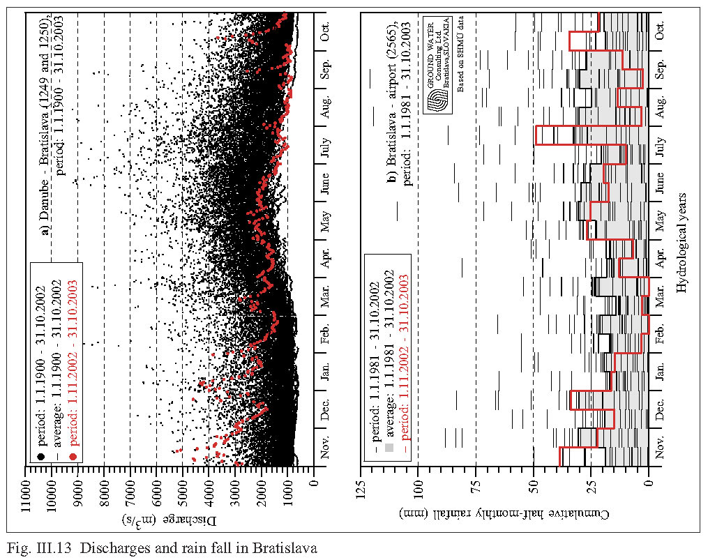
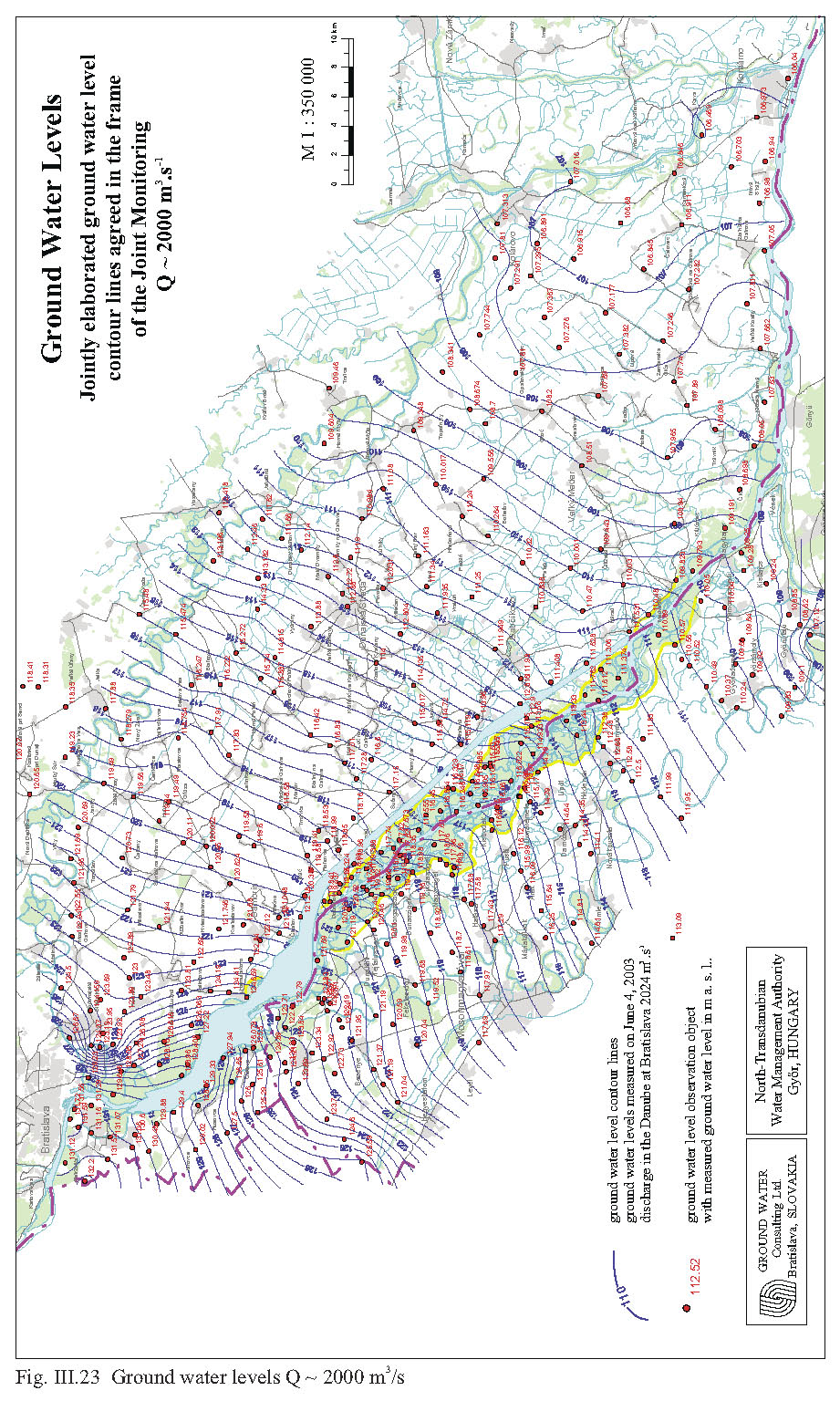
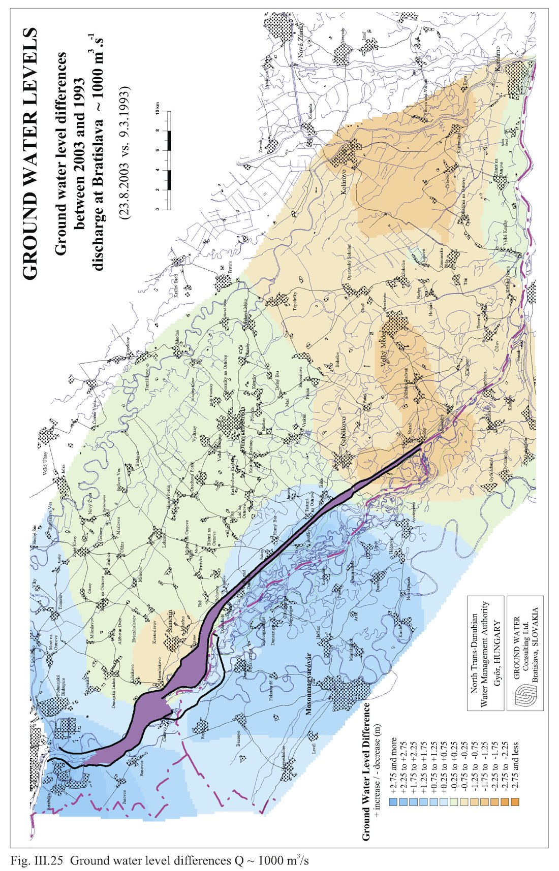
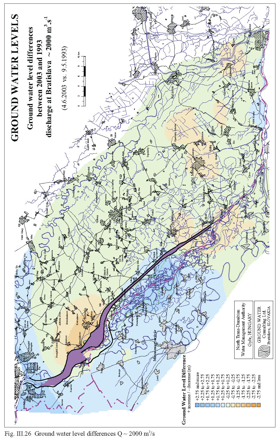
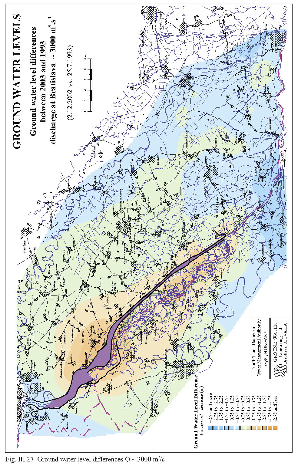
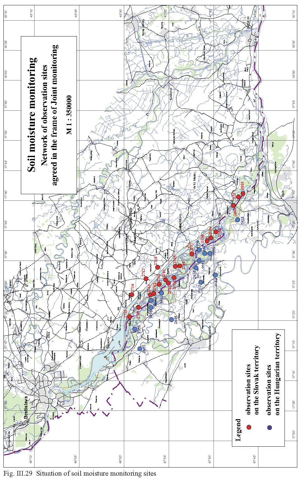
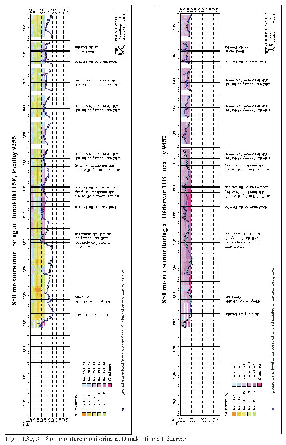
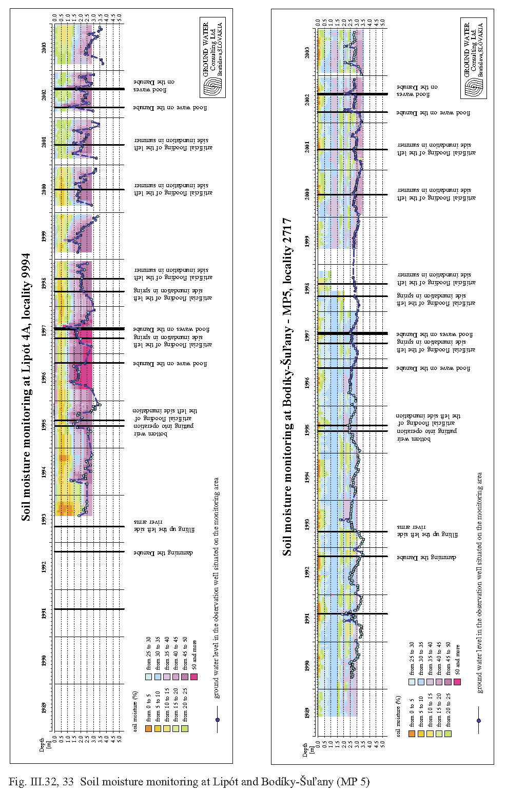
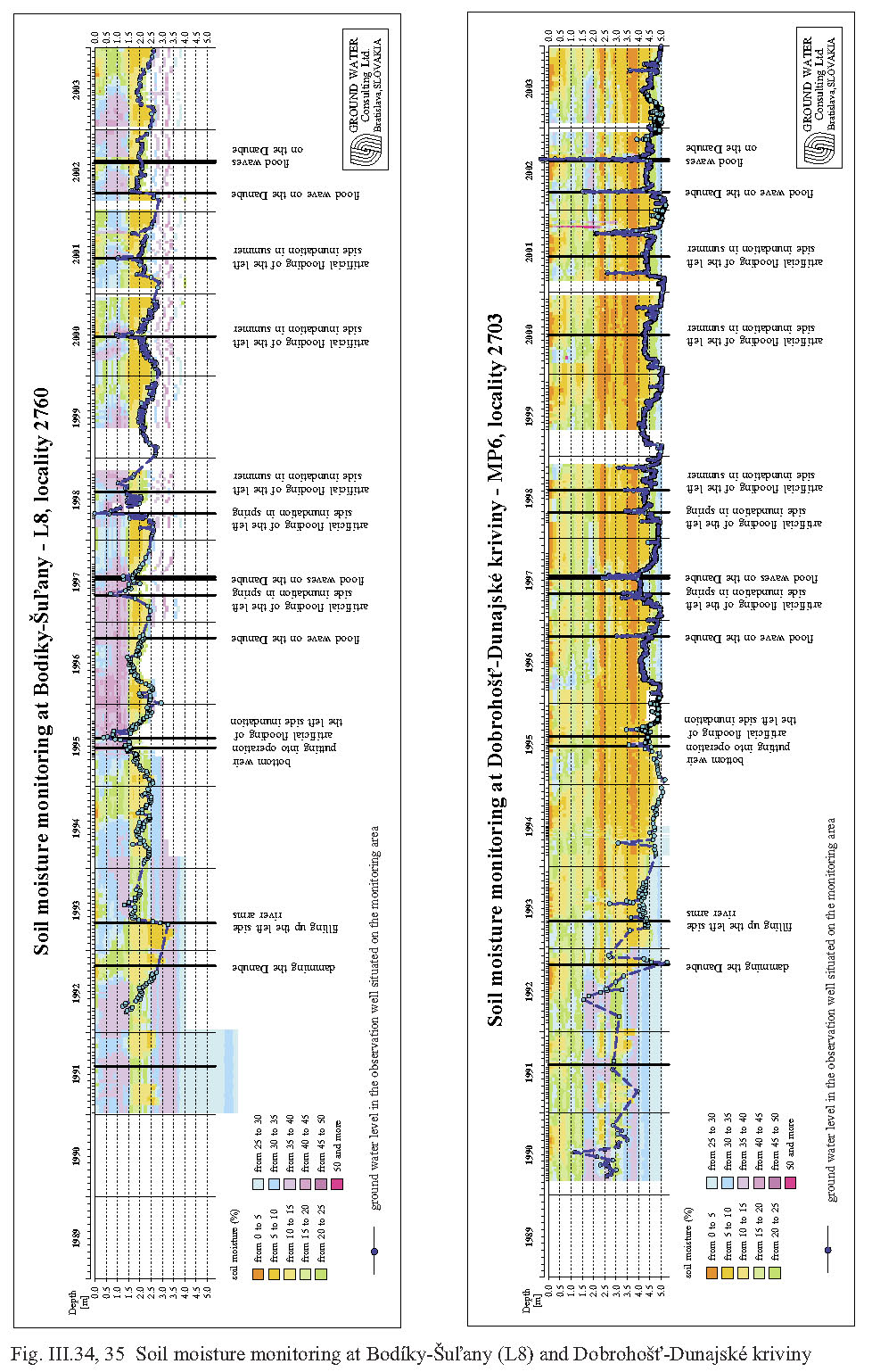
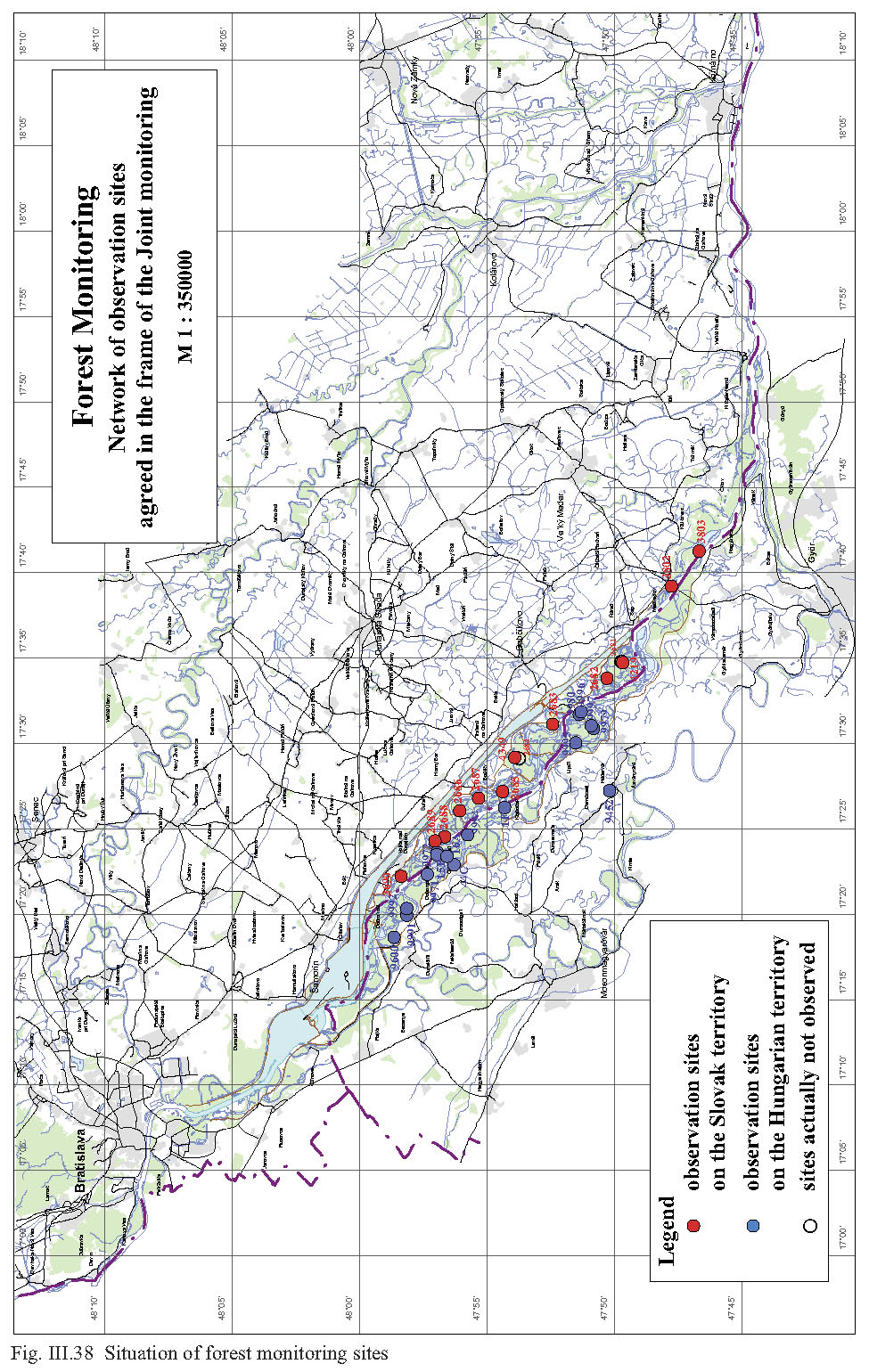
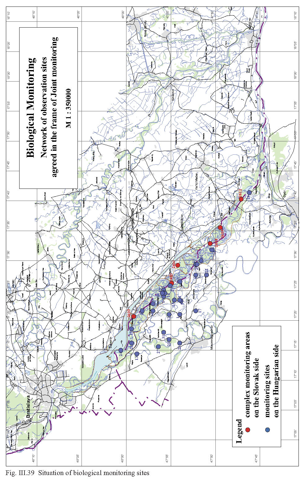