|
V.2.10. Ecological significance and vulnerability of the Danube floodplain forest ecosystems Ferdinand Kubíček, Július Oszlányi Forest ecosystems along rivers represent a significant landscape-ecological element forming the overall character of a landscape. Floodplain forests in particular are a characteristic dominant feature of this territory. Floodplain forests are stands consisting of hygrophilous and flood tolerating wooden plants and herbs in the vicinity of watercourses, conditioned by floods and a high ground water level. The soils are very rich in nutrients because they have developed on sediments of rivers bearing gravel, sand and humus from upstream parts of the river catchment. The dynamic of ground water is crucial for vegetation of floodplain forests, meaning floods, moistening of the plant rhizosphere in the spring and summer, autumnal drought, enrichment by nutrients etc. Ecological significance and vulnerability Ecological significance reflects evaluation focused on landscape quality, determines the scale for preservation of positive ecological processes and functions in the landscape [1]. Ecologically positive landscape elements are considered those elements that create very good prerequisites for the functioning of positive processes in the ecosystem and for protecting and preserving suitable conditions for maintaining and restoring the landscape gene pool, natural resources, ecological stability and biodiversity. This is evaluated according to the degree that ecological and selected positive functions of the landscape are fulfilled. According to Jurko [2], territories with high ecological significance are indicated by increased quality of gene pool, health, landscape aesthetics and further environmental and socio-economic functions. In regard to the character of floodplain forests of the Danube floodplain after the Danube damming, we evaluated their ecological significance by the three following degrees: 1. degree – ecologically very significant forests 2. degree – ecologically significant forests 3. degree – ecologically less significant forests. A significant element for determining ecological significance is the vulnerability of vegetation (forests). Evaluation of vegetation according to its vulnerability by external factors is very complex, because the vegetation units represent a complex, and stress factors also act in complexity [2, 3, 7]. If the structure of vegetation has not completely changed and is able to return by means of its own auto-mechanisms to the original state, the change was caused by stress factors. On the other hand, the destructive factors destroy vegetation. Similarly, the permanent negative interventions that essentially change the present environmental conditions lead to a situation where the vegetation (forests) is not able to return to its original state. The vegetation disappears or is replaced by other types, which gradually adapt to the new conditions (for example a rise or decline in the ground water level). The degree of vulnerability or expected possible change in vegetation does not depend only on the type and intensity of the negative impact, but also on different circumstances that can essentially influence such consequences. The vulnerability of floodplain forests was evaluated according to Roberts [6] as a “relative scale of the ability of vegetation type to resist certain pressures and changes without loss of its quality” in the three following degrees:
We selected the following stress factors for evaluation of floodplain forest vulnerability: A – Artificial changes of vegetation – afforestation, the introduction of new tree species and neophytes, destruction of vegetation. B – Mechanical destruction of soil surface – water or wind erosion, concentration of people, recreational activities (trampling), hunting and angler activities. C – Changes in ground water level – increase, decrease. D – Chemical pollution of environment –eutrophisation, influence of emissions, synathropisation. E – Clear-cutting. Evaluation of the Danube floodplain forests Several types of forests occur in the Danube floodplain, in dependence on flood frequency and ground water level [8]:
Evaluation of the ecologic significance of the above forest types, as well as of their vulnerability by stress factors, is given in Tab. 1. On the basis of ecological significance and vulnerability, the Danubian floodplain forests can be divided into three categories: 1. ecologically very significant forests – the willow-poplar floodplain forests and original cornel – oak forests with some rare and disappearing species. Accounting for the high degree of ecological significance these forests categories are very vulnerable, hence sensitive to selected stress factors. An extraordinarily stressful factor for softwood floodplain forests is a drop in the ground water level. For cornelian-oak forests the changes in ground water level are not so significant. The water deficit determines the occurrence of rare xerophytic and subxerophytic vegetation. 2. ecologically significant forests - transitional and hardwood floodplain forests and hornbeam-oak forests, which are medium vulnerable, hence sensitive to selected stress factors including a decline of ground water level, but highly sensitive to any anthropogenous changes. 3. ecologically less significant forests – monocultures of all types with low vulnerability. At present poplar monocultures constitute a high percentage of the Danube floodplains and their ecological significance is evidently lower than that of the original floodplain forests, although their economic functions in forestry is not negligible. Their vulnerability is lower and depends on silvicultural activities. Natural and semi-natural Danubian floodplain forests have a high ecological significance and are relatively highly vulnerable to stress factors. In spite of the fact that these communities have undergone many changes during the last hundred years, there is still a presumption that they will be preserved for future generations provided mankind treats them sensitively. Table 1. Ecological significance and vulnerability of the Danubian floodplain forests
Influence of construction of the Gabčíkovo project on floodplain forests In the area influenced by the construction of the Gabčíkovo project it is not possible to speak about any original wooden plant composition of the floodplain forests. Already long before the construction the main trees in the transitional and softwood forests had been changed by the preference or introduction of euro-American poplar cultivars. In a certain sense the floodplain forests were also influenced by further changes like deepening of the Danube riverbed due to gravel exploitation in the 1960s and the almost complete extinction of elm after the calamity of Dutch elm disease. A major part (about 80%) of existing Danube floodplain forests between the villages of Dobrohošť and Sap consist of Euro-American poplar cultivars with a predominance of the clones “I 214” and “Robusta”. These facts manifest in the distribution of individual forest types both before and after the construction of the Gabčíkovo structures. Before its construction, two types of floodplain forests were most represented here – the hardwood floodplain forests in the upstream part of the territory, with softwood floodplain forests in the within-dike zone. The softwood floodplain forests, especially in the downstream part, also covered a relatively large part of the territory, while other forest types covered only a very small part of this area. After construction of the Gabčíkovo structures the surface of floodplain forests decreased by 30%, which influenced the distribution of individual types of forests. The surface of hardwood floodplain forests decreased to approximately 8%. On the other hand, the surface of transitional and softwood floodplain forests has almost not changed. However, it is to be noted that there is a general tendency toward the transformation of plant communities from more humid to drier ones, irrespective of the impact of the Gabčíkovo structures. This is caused by the reduced transport of sediments (dams in Austria and Germany) and a drop in the Danube bottom (for details see [4, 5]). Finally, it is possible to state that the preservation of present ecological (growth) conditions in the area of the Danube floodplain forests will depend on an adequate level of ground water. There is a chance that operation of the intake structure at Dobrohošť can provide favourable conditions for development of the floodplain forests. Other possibilities include underwater weirs to increase the Danube water levels and new meandering eupotamal. References
V.2.11. Evaluation of growth and some habitat characteristics of production forest stands in permanent monitoring plots Vladimír Bajcar In the frame of monitoring of forest communities, evaluation of selected parameters of individual planted trees or of tree clones is regularly carried out on the permanent monitoring plots. Herbage vegetation is also monitored. The observable or measurable parameters can have, depending on objective circumstances and subjective approach, quantitative or qualitative character. The number of permanent monitoring plots in the forests in the area of the Gabčíkovo project, evaluated from a forestry research viewpoint, fluctuated. Until now, the following monitoring plots were evaluated: L3, L4, L5, L6, L7, L8, L 9, L10, L11, L12. In addition, the plots L14, L18, L19 and L20 situated in the area Podunajské Biskupice region were monitored. The plots L3 and L4 are situated in the area between the Gabčíkovo harbour and the confluence of the tailrace canal with the Old Danube. In this area ground water level couldn’t be regulated. All other plots are situated in an area with a more or less controlled ground water level. In 1998, because of limited financial means, the forest monitoring was carried out only in the downstream part of the area from Dobrohošť to Sap, where plots L3 – L12 are situated. In 1999 we established the plots L25 and L26 in the area downstream where the tailrace canal joins with the Old Danube. This area is out of the direct influence of the Gabčíkovo project. The monitoring results from 1993-1996 were summarized and published in final reports [11], in which the area was divided into five parts according to ground water level fluctuation and its relationship to forests stands. The results of natural environment monitoring in the area influenced by the Gabčíkovo project are published annually in final reports, for example [1, 3, 4, 5, 6, 7, 11, 12]. Each monitoring plot is equipped with a well in which the ground water level is measured in weekly intervals in order to establish its seasonal changes and long-term characteristics. In addition, series of six further wells, oriented perpendicularly to the Danube, are crossing L10 and L12 plots. The basic quantitative parameters of planted trees are documented by measuring the girth (at a breast height of 1.3 m) and the tree height. These parameters are annually measured after the end of vegetation season. Stem girth is measured in all living trees in the monitoring plot; 50 living trees were chosen at the plots establishment. The height of three selected trees was measured in each plot. In addition, we measured the height of all trees in the monitoring plots at the end of 2005. During the vegetation period, we measured girth increment at a breast height in the plots L3, L5, L6, L8, L10 and L12 in three selected trees. In the case of a plot that had been clear-cut we measured the increment in 3 trees of corresponding species in vicinity of the clear-cut plot. The growth in all plots corresponds, in principle, to the age and health state of the planted trees. In the older monitoring plots, it is not possible to expect faster growth. The disadvantage of the method used was measuring tree height in only in 3 selected trees, which do not represent all of the trees in the plot. There also arose complications and possible biases when some of these trees died and were replaced by other trees with corresponding height. Other problem in older stands with limited growth rate is that we are unable to measure tree height accurately. The accuracy of devices to measure height is only 0.5 m. It means that, assuming no other mistakes, we are not able to record growth increments smaller than 0.5 m. Other inaccuracies occurred, which are known. Prevention is measurement of a larger number of trees and in larger time intervals (in most tree species 2-5 years). Results are interpolated for individual years. In plots with young plantations of poplar cultivars, the height increment can be measured annually without problems. In the plots with old trees, as well as in plots L18, L19 and 20, the growth is so slow that with a measurement accuracy of 0.5 m, and real annual increment of 10-20 cm a zero increment could be recorded during several years. Than suddenly an increment of 0.5 m occurs, which would not correspond to the reality. Therefore it would be better to measure height increments in longer intervals. Measurements of girths and subsequent calculation of those increments are more reliable because the measurements are more accurate. Trees that grow in better conditions usually have bigger trunk’s increment. But age and density of the stand or by silvicultural measures in the stands also influenced the diameter of the tree trunks. The trees are reacting on more space and light input, resulting from thinning, by increased increment. The girth increment in selected monitoring plots is also evaluated from the viewpoint of its beginning, culmination and final phase. Graphical comparison of its course with the changes in ground water levels show that increment of some trees, more or less positively, corresponds to the increase of ground water level with some delay, usually 1-2 weeks. But some trees do not show any change relation to ground water level. Clear confirmation of this relationship is complicated due to expected influence of additional factors, especially temperature and its fluctuations, atmospheric precipitation, soil moisture and soil conditions, which vary widely in the monitoring plots. Also the biosociological position of the tree in the stand and, perhaps, by some unknown intrinsic processes influence this relationship. At the same time it is clear that increased ground water level can influence positively the growth rate to certain point. After it’s reaching the ground water increase has no more a positive effect or, on the contrary, can act negatively. Measuring of the tree trunks and a comparison of their average values along growth curves as well as characterisation of individual site classes of individual tree species or clones in individual monitoring plots from 1990-2003 were published in graphs [13]. This paper also includes the comparison of cumulative girth increments in selected plots during the period 1997-2003. The diagrams show not only relatively good growth of poplar cultivars, but also the hardwood broadleaved trees, from the viewpoint of their quality classes and perspective of their next development. In each monitoring plot we evaluate the health of all trees at least twice a year. We evaluate ecologically and economically significant diseases, the occurrence of pests and, among the deficiency diseases, chlorosis of some broad-leafed tree species. In poplars, we evaluated Chondroplea populea, Marssonina brunnea and Melamspora sp., infestations brown sap flow, the long-horned beetle Saperda carcharias and insect defoliators. In other tree species than poplars or willows we yearly evaluated the degree of defoliation and the degree of yellowing leaves as a result of calciosis. In the monitoring plots where white willows existed we evaluated, aside from the same pests and diseases as in poplars Rhabdophaga saliciperda infestation. In addition, in some years, we evaluated the percentage of loss of assimilation organs as characteristics to the results obtained by aerial surveying. This characteristic is very similar to degree of defoliation, but it is more accurate and time demanding. It is important in documenting the health of the trees. The characteristics mentioned above are important for evaluation of biotic and abiotic impacts on forest environment. Impacts of construction and operation of the Gabčíkovo project is transferred by surface water, ground water, and soil moisture regime. The health state of forest is simultaneously influenced by other various factors, mentioned before. Often the trees die primarily due to damage during thinning and secondarily due to infection of wounds by wood-destroying fungi. The time span between in infection and the manifestation of disease can differ and can be influenced by factors such as the tree’s ability to occlude the wounds or by the fungi’s ability to spread in the wood. Infected trees can dry or rot and eventually fall in a strong wind. Among other evaluated pathogens, the health of the trees in plots L18 and L19 which contain Pedunculate oaks and Turkey oaks, was affected by the parasitic shrub Loranthus europaeus and fungi Microsphaera alphitoides and Ophiostoma spp. Microsphaera alphitoides reduces the vitality of the infested trees and can possibly reduce the rate of growth in these trees. Ophiostoma spp. causes a tracheomycotic disease in of oaks known as oak plague. This fungus as well as Loranthus europaeus, can kill the trees directly. Particularly, in the last several years, damage to tree plantations by red deer has become significant. It can also be one of reasons for unsuccessful reforestation in the monitored plots. Some final reports [6, 7] consider the gradual decline of the ground water level as the main reason for unsuccessful reforestation of those plots, which were earlier covered by relatively successfully poplar plantations whose deep root systems were able to adapt to the declining water level. However, eventually, younger seedlings with shallow roots depended only on atmospheric precipitation after planting. Poplars demand a lot of available water during the vegetation season and the precipitation water is insufficient in light soil in years with standard or substandard precipitation. During the establishment of the monitoring plots, we marked 50 trees in each plot, with accent on their probable span at the felling age and in regard to their actual qualitative and quantitative parameters. Out of the silvicultural interventions in the permanent monitoring plots, which we cannot influence and which are under the supervision of respective forest managers, natural factors, like drying of individual trees due to diseases or infestation by pests, suppression and dying off due to competence of neighbouring trees or windfalls and breaks, are playing an significant role. All these factors play a role in the gradual reduction of selected trees in individual monitoring plots. Efforts to select the trees for evaluations that will probability survive up to the felling age can negatively influence objectivity of evaluation. The selection of good quality, dominant or co-dominant trees growing in a span, excluding their removal by thinning, or the selection of above-average trees as to quality and quantity of wood mass and health, reduces representability of these trees in monitoring. Sometimes, this influence is only theoretical, other times it can be real. This happens most when founding monitoring plots or in the marking of trees in newly planted areas on clear-cut plots. On the other hand, this influence is minimal on the plantations of poplar cultivars in good quality stands, in good quality habitats, because these stands consist of genetically identical individuals. This selection process has a bigger effect in areas where plantations of poplars and willows are not homogenous and where environmental factors play a big role. Sometimes the genetic predisposition of the selected trees does not reflect what we would call the ”theoretical average” of the whole population. For this reason, it seems to be more desirable to mark of plots of a certain size, which would correspond to certain presumed number of trees of un-felling age. This number should be representative, with some reserve from mathematical-statistical viewpoint, of the monitored and measured characteristics of individual trees. Although the selection should be based on concrete goals, practical ability to measure and variability of measured characteristics, the minimum number of measured individuals selected is generally 30. On the basis of long-term experience and under the assumption that certain principles are maintained at their selection, this number can be taken as a representative selection for a concrete population of tree species in a given site. If we accept this number as sufficient for our conditions (it is to be noted that this number means number of trees in felling age), it should be still increased to be on the safe side. Subsequently the size, suitable shape and dimensions of monitoring plots should be determined by means of the growth rate tables and optimum numbers of trees per hectare. The size of monitoring plots can be also determined in other ways based on of experience or according to an agreement between the Slovak and Hungarian side. It is to be noted that our task is not to characterize the population of the given tree species in the monitoring plot, but the habitat in general. This is especially important in the case of plots with plantations of poplar cultivars, which cannot be taken as a population due to the fact that they are genetically identical. The most significant characteristic recorded during the monitoring of the natural environment influenced by the Gabčíkovo project is the ground water level and its changes not only during the vegetation season, but also through the entire year. Šmelko [9] evaluated changes in ground water level in the monitoring plots L4 – L12 from 1992-1995 from the viewpoint of average level and variability and its relationship to the thickness of the soil. He stated that it did not essentially change in plots L4, L6, L7, L8 and L9, but it considerably declined in plots L5, L10, L11 and L12. Šmelko [10] compared ground water levels before and after the damming of the Danube in the area of Podunajské Biskupice, where he recorded significant ground water level increasing in 1993, 1995 and 1996 in comparison with year 1992. An exeption was monitoring plot L18 where the ground water level was already relatively high. He declared an improved growth and health of trees. Neštický and Varga [3] published diagrams of hydrological regime development in selected monitoring plots from 1993 to 2001. They stated that there was an unfavourable ground water level in the area where the ground water level can be controlled. Exception is the stretch between the line F and mouth of the Bakanské rameno arm to the Old Danube, where monitoring plots L5 and L6 are situated. They also stated that the ground water levels are supported by the increased discharge in the arm system and in the old riverbed. The area between line G and mouth of the Bakanské rameno arm (represented by the plot L5) is not influenced by changes in the ground water level resulting from floods. The attached diagrams illustrate the changes in the ground water level in individual monitoring plots in relation to terrain altitude from 1997 (2000) to 2005. The diagrams show the beginning of a gradual decline of the ground water level in all monitoring plots, except for the plots L10 and L11, where the ground water levels seemed to be balanced throughout the monitoring period. The diagrams also show the rate of the ground water level fluctuations. The strongest declining trend of ground water level is in the area outside of the impact of the hydraulic structures and areas outside of the river branches controlling the ground water level. Ground water level can be relatively strongly influenced by a favourable year, for example 2005. Flooding of monitored plots, during which the ground water level could not be measured and therefore the data are missing, also influenced evaluation of trends. Phytocoenological relevés (notation) of spring and summer aspect of herbage stratum is elaborated each year. To do this, we used the professor Zlatník’s scale, which is a standard scale used in forest typological studies in Slovakia. It represents a finer modification of the Braun-Blanquet´s scale. However, for practical reasons the relevés are not recorded on a fixed network of small plots, but are recorded by an overall survey of herbage synusia in the whole monitoring plot. Subsequently, we can compare the coverage and presence of a species with that of the preceding year. Initially, on small plots (fixed plots of 1x1 m), we counted all individual herbs present. We than took average samples of selected species in order to establish the phytomass of the given species and it’s annual changes. However, the plots were gradually damaged during thinning or felling. Therefore, even if other plots, in almost the same position, replaced them, the results would be strongly biased, for example, by the disappearance of some originally abundant species after such interventions. For this reason, we discontinued this study after the last of the plots disappeared and we have not resumed this part of the monitoring. In addition we evaluate herbage vegetation on transects by counting all individuals of all present species of herbs growing on a 10 m long line at each monitoring well. On the basis of relevés recorded during the summer aspect in individual monitoring plots, we calculate the average eco-numbers in relation to ecological factors like the content of nitrogen in soil, continentality, pH, light, temperature and humidity. We also looked at how individual life forms of plant in herbage stratum were represented. Average eco-numbers including the percentage of indifferent species in individual monitoring plots in 1999 (2000) to 2005 are presented in the attached table. Although the composition of species in herbage stratum in individual plots changes, changes of eco-numbers are not as strong as expected, even after such extreme interventions like thinning and felling. When the herbage stratum is greatly disturbed than the light condition and species composition change. After regeneration, felling ruderal vegetation occurred in all plots. It is still influenced by soil preparation before re-afforestation and treatments of the plantations. Generally it can be said that the herbage stratum in the forest is much more influenced by forest management intervention than by other factors. The regeneration felling took place in plots L3 in 2001; L5 in205; L6 in 2002; L7 in 1999; L9 in 2001; L11 in 1999; and L12 in 2005. References
V.2.12. Evaluation of defoliation in forest stands based on aerial survey Rastislav Raši Introduction, problem and literature survey Aerial survey is a significant and widely used method of the remote sensing. Their advantage results from easy modifiability of scale and of the film material used. The ability to evaluate and compare time series of photographs is important for periodical evaluation of the characteristics of the forest monitored. It is becoming more important to detect anthropogeneous changes in landscape elements and in natural and economic conditions. The spectrozonal colour infrared (CIR) aero-photographs and field investigation by selective methods are used on a large-scale to monitor the health of the forest on the local and regional levels. Kodak 2443 film is a positive material depicting the objects in the false colours – blue represents objects reflecting the green part of the light spectrum, the green represents objects reflecting the red part of the light spectrum, and red represents the objects reflecting the infrared part of the light spectrum. A description of the properties of this film was published in [5]. Experience from the use of this material for the evaluation the health of the forests and from the evaluation of degree of damage to individual trees, by means of visual interpretation are summarized in a manual issued by the European Commission [3]. The application of aerial remote surveying of the Earth and the activities, which involve the International Cooperation Program: Forests (ICP Forests) are described in the report [4]. In Slovakia, Kodak 2443 film was used to evaluate of state of the forests by [11], who evaluated damage to tree crowns through the use of these digitalized spectrozonal photographs. Visual and digital evaluation of the state of the forests by means of spectrozonal photographs was also carried out in the Horná Orava region [9], where colour differences were used primary as an interpretation feature, while the texture, structure and shape of individual trees served as secondary interpretation features. The analogue photographs were digitalized into red (R), green (G) and blue (B) components and analyzed. The combination of the R-G and G-B channels were found to be most suitable for distinguishing the health of and damage to trees. Compared to field evaluation, the aerial surveying was biased by a systematic mistake, which slightly increased during an automatic interpretation. The evaluation of quite large floodplain forests in the area of the Gabčíkovo project requires, in regard to surface, remote sensing methods, supported by field observation [1, 8]. Material and methods The area is situated in the Danube arm system and is bordered by the derivation canal of the Gabčíkovo project and the Old Danube [6]. The surface area is plain, covered by floodplain forests belonging to two forest management complexes - Šamorín and Gabčíkovo. The forests in this area have a surface of almost 3000 ha and are divided into more than 900 units. The tree layer is dominated for the most part by fast-growing trees – poplars (63%), above all, poplar cultivars (9%), white and black poplars and willows (17%), crack willow, ash (Fraxinus angustifolia) (7%), and other broadleaved trees (12%), like pedunculate oaks, locust trees, black walnuts and alders. Due to the representation of individual tree species, the average age of the forests is low, approximately 20 years. The aerial CIR photographs were made by a seminetric camera Hasselblad 70 MK, using 70 mm Kodak 2443 film. The surveying was carried out in 1996, 1999, 2002 and 2005, always in August. The scale of the original photos ranged from 1:16,000 to 1:33,000. The arial-photographs were scanned with resolution of 600 dpi into separate files represented by R, G, B colour components. The infrared light spectrum is encoded on the film onto the red (R) components, while reflectivity of the red component of the light is encoded onto the green (G) component of the picture. When compared with the health vegetation, the damaged vegetation, or vegetation with a reduced amount of leaf biomass, reflects the red light more intensely and the infrared light less intensely. It is a result of pigments content, cellular structure, and the water content in the leaves. Visual evaluation of arial-photographs This method is sufficiently accurate and simple, but relatively laborious. Causal relationships resulting from character of surrounding of the object should be taken into consideration. In addition, results of field observations should also be included into interpretation. This method is appropriate for evaluating the most important areas and small localities. More details of evaluation are given mainly in [3]. Semiautomatic damage classification In this case, the state of tree crowns is evaluated in regard to loss of assimilation organs (reduction of foliage biomass) and change of their colour. This method is less time-consuming than visual evaluation, but usually it is less accurate. This method depends more on software and hardware as well as on experience with processing digital images. It is used to evaluate of state of forests on a larger scale, when the visual interpretation would be time consuming too much. The aerial-photographs from 1996 and 1999 were adjusted in digital form by means of statistical-empirical radiometric correction. This adjustment focuses on brightness intensity on margins of the aerial-photograph and its brightness variability caused by the geometric position of the Sun, camera and object. Based on the analysis of selected photographs depicting relatively homogeneous areas, a statistical-empirical model of brightness reduction was derived for each colour component of the picture (R, G, B) and for each period (1996, 1999). Brightness values were identified in the selected aerial-photographs in a regular point network with known coordinates. These values represented dependent variable. The aerial-photograph coordinates represented independent variables. The least-square method was used for optimising the regression relationship models with regard to values of brightness and position. The models were subsequently normalized according to equation (1) and the individual components of the picture were corrected according to equation (2). mn = 100 - (100 * (mo - mo min)) / (mo max - mo min), (1) Where mn – % of normalized brightness reduction, mo – original value of the model, mo min; mo max – minimum and maximum value of the model. cc,i x,y = 100 * co,i x,y / (100 - mn,i x,y), (2) where cc,i x,y – corrected brightness value of i-st picture component in position x,y, co,i x,y - original brightness value of i-st picture component in position x,y, mn,i x,y - normalized brightness value of i-st picture component in position x,y. Normalized aerial-photographs were transformed in the coordinating system on the basis of common control points identified in the aerial-photograph and in the digitalized forest area map in the scale of 1:10,000. At least 5 points were used to transform each photograph and, in regard to the generally plain character of the relief, the affinity transformation was usually sufficient. Method of two-phase sampling with regression analyses After adjusting the coordinates, the photographs were jointed into a mosaic. By means of maximum likelihood method we classified the tree vegetation and other landscape elements. For further processing we used only those picture elements, which were classified as tree vegetation. According to a digital forest stand map, we extracted the average values of brightness in the individual components (R, G, B) from the mosaic for each unit of spatial arrangement of forests. Extraction of these values represents the first phase of analysis, in which the values of auxiliary variables are set for all the evaluated units of the forest area arrangement. Further, auxiliary variables were derived from the Forest Management plan: age, tree density and species composition of the tree layer. In the second phase, the variables were detected as accurately as possible for a limited number of selected units. In these cases we detected defoliation in selected spatial units. We selected 50 spatial units from each period. In each, we visually evaluated tree defoliation in four ten-tree clusters by means of stereoscope, and we rounded the values for individual trees to 5%. Average defoliation in the whole spatial unit was established according to group selection. If the number of trees in each group was equal, we could calculate the average defoliation in the spatial unit (plot) as an arithmetical mean of defoliation of the trees evaluated. The next step was creation of regression model. In order to do this, we used multiple regression analyses, in which the defoliation estimated visually in the selected spatial units represents the dependent variable, while the average brightness values in individual picture components and the auxiliary data taken from the Forest Management Plan, represent the independent variables. The aerial-photographs from different years always differ to certain degree because of changes in light conditions and variables that affect film processing. Therefore, it is necessary to create a special regression model for each period. Subsequently, the values of defoliation in each spatial unit were established by the introduction of the auxiliary variables into the resulting equations of regression models. Method of visual evaluation with the application of two-stage selection This method is used to identify potential tree-crown damage. The first stage is to select spatial units of forest stands. The second stage consists of selecting the trees in these stands to evaluate. In both stages, we can apply systematic or random selection. In order to establish the average defoliation level (x aver) in an area, we assume that the units selected in the first stage ni represent the whole region, and the units selected in the second stage mij represent the selection units from the first stage. Average defoliation is calculated as a weighted average of the first selection unit, where the weight is the area of the selection unit ai at the first selection step: x aver = (Σxi aver * ai) / (Σai) ; xi aver = (Σxij) / mi (3) where xij is defoliation of the j-th evaluated tree in i-th selected stand, mi is the number of evaluated trees in the i-th selected stand. Mean error of the selection average is established on the basis of variances within and between selection units in the first step of selection [10]. Supervised classification of defoliation classes Defining the training sets characterizing selected defoliation cases enables us to obtain visual characteristics (variances and average values of brightness) of these classes. On basis of these characteristics, we classify the picture elements into individual defoliation classes on the principle of maximal probability. This method was applied to evaluation the CIR aero-photographs from 2002. Results We present here our interpretation of the health of the forest in the years 1996, 1999 and 2002. Using application of the two-phase sampling with regression, the regression model for 1996 includes, the spectral characteristics derived from the CIR aerial-photographs, and also autochtonous poplars in the spatial units. The 1999 model includes also willows representation. These variables significantly increase the accuracy of the regression model. In the case of autochtonous poplars their sparser foliage, in comparison with the foliage of cultivars, can be explained by their higher age. In the case of willows, the spectral reflectance of fully foliated willows is comparable to the reflectance of partly defoliated poplars due to their different shape, surface, and arrangement of willow leafs. The regression models were constructed (see Tab. 1). Tab. 1. Regression models for establishment of defoliation on base of two-phase sampling with regression in 1996 and 1999
Summary results for the classification of individual spatial units into the defoliation classes are shown in Tab. 2 and Tab. 3. Some stands were excluded from evaluation, if they were not displayed completely on the aerial-photographs or if they were covered by clouds or by their shadows. Similarly, the clear-cut stands were excluded from evaluation. Tab. 2. The summary evaluation of foliage loss of forest spatial units in 1996
Tab. 3. The summary evaluation of foliage loss of forests spatial units in 1999
The average defoliation in forests in 1996 was x1996 = 16.9 % ± 0.5, while in 1999 x1999 = 13.2 % ± 0.8. The results show that severely defoliated areas do not occur in the area studied, while the medium defoliated stands occur here only sporadically. Shifts of stands between defoliation classes are characterized in Tab. 4. Tab. 4. The foliage loss level changes between 1996 and 1999
The results indicate the forests in this area are generally healthy. According to forest health monitoring that took place in Slovakia in the same years [2], average defoliation in the evaluated areas was lower than the average defoliation of broadleaved trees in all of Slovakia (x1996_SR = 23.8%, s1996_SR = ±0.9%; x1999_SR = 20.4%, s1999_SR = ±0.8%). Classification of stands into defoliation classes on the basis of the evaluation of CIR aerophotographs in 2002 is shown in Tab. 5, 6. Tab. 5. Evaluation of damaging of forests stands in the area studied in 2002
Tab. 6. Evaluation of damaging of forests stands in the area studied in 2005
Example of health state of foliage, which is an indicator of healthy forests is shown on Fig. 1a and Fig. 1b. References
V.2.13. Monitoring of aquatic insects in the area of the Gabčíkovo hydraulic structures Eva Bulánková, Iľja Krno When assessing processes taking place in aquatic ecosystems, aquatic insects are used as indicators of immediate and long-term changes. Aquatic insects represent an essential part of the macrozoobenthos and also serve as the main food source for fish. The strong changes to the hydrological regimen of the Danube main channel and arm system caused by the Gabčíkovo hydraulic structures are also reflected in communities of aquatic insects represented predominantly by Ephemenoptera, Plecoptera, Trichoptera and Odonata [7, 8, 9, 10, 11, 19, 3, 4, 6]. These taxonomic groups represent a component of several metrics of the AQEM evaluation system, based on which a multimetric index is elaborated for assessment of the ecological quality of water in different types of streams in the EU. The aim is to use these metrics to evaluate changes caused by the Gabčíkovo project to the structure of aquatic insect communities in the Danube main channel and parapotamal and pleisopotamal type arms over the last ten years of monitoring. Material and methods In 1995-2005 we sampled aquatic insects (Ephemenoptera, Plecoptera, Trichoptera- larvae and imagoes, Odonata - larvae) in the Danube main stream, where we focused mainly on the stretch Dobrohošť – Bodíky (Monitoring Plots MP 6 and MP 9), and in two different types of arms near Bodíky (parapotamal, MP 9) and near Gabčíkovo (pleisopotamal, MP 10). We used the kicking technique for the sampling. The material was taken during three seasonal aspects, in spring, summer and autumn, and fixed by formaldehyde. Metrics were calculated by means of the program AQEM [1], whereby we focused above all on metrics based on the monitored groups of aquatic insects. Results The representation of aquatic insects according to the number of taxa, genera and families at individual monitoring sites is presented in Fig. 1. In the main stream – eupotamal – we recorded a decrease in the biodiversity of Ephemenoptera, Odonata, Plecoptera and Trichoptera up to 2003. Then an improvement of this state occurred, with even Xantoperla apicalis and Taeniopteryx schoenemundi, two rare and endangered species of Plecoptera, also appearing for the first time. At the same time, there is a clear decrease in the number of taxa of mayflies, whose occurrence is very sporadic in the Danubian river basin. In both river arms the representation of mayflies decreased already in 2000, when the dry and warm summer [1] caused a low water level, accompanied by reduced oxygenation, turbulence and increased content of organic substances in the water. The short-term artificial flood in 2001 and strong natural floods in 2002 eliminated this unfavourable state. This manifested in an increased proportion of mayflies and caddisflies up to 2004, when the absence of floods once more caused a strong decline of these insects. With regard to dragonflies, we observed an increase in the number of taxa in the arm with stagnant water (pleisopotamal) in 2002; while in the discharging arm (parapotamal) we observed an increase in 2003 (Fig. 1). This was probably caused by longer lasting stabilization of dragonfly communities after the flood of the site at Bodíky, where the floods influence lasted longer. The saprobic index (SI) did not show any major fluctuations in either the main stream or in the arms (Fig. 2), but it reflected a time shift of increased organic content, which culminated in the pleisopotamal type arms already in 1999 (this corresponded to the minimum water volume in the arm), whereas we did not record this state in the main stream and in the discharging arm until as late as 2001. It was also reflected by the development of metrics indicating organic pollution (Fig. 2). BMWP indicates the average water quality in the main stream and it showed the worst value in 2003 (bad quality) and in 2001, when the lowest value of BMWP was also recorded in both arms. ASPT expressing organic pollution recalculated per number of taxa indicated a drop in organic pollution in the Danube main stream in the last three years, while in the arms it decreased in 2001, but after the floods in 2001-2002 the values of BMWP and ASPT returned to the original state. The changed hydrological and trophic conditions are also reflected in the metrics of trophic guilds (Fig. 3). They cause an increase in the representation of collector-fiterers in the mainstream, while in the parapotamal type arm the portion of collector-filterers and scrapers increased. Large drops in the water level in the main stream reflected in fluctuations of the representation of trophic groups. Three peaks in the occurrence of scrapers and collectors (in 1996, 1999 and 2001) correspond to the years following warm and dry seasons with the absence of floods. In the pleisopotamal type arm, during periods of increased organic content, the proportion of predators (represented by dragonflies) and shredders (represented by caddisflies) increased. When comparing metrics characterizing the relation of the taxa recorded to streaming (Fig. 4), we found that the proportion of rheo-limnobiont taxa had increased in the Danube to the detriment of the reophilous taxa, especially in 2003-2004. This increase coincides with the increased metric %Pe, which expresses the proportion of taxa bound to pelal. Reduced stream velocity in the Danube, especially at Dobrohošť, caused a decline in the representation of reophilous species and an increase in the representation of the semireophilous and pelophilous species. Increased turbidity and clayish sediment negatively influenced scrapers and changes the structure of collector-filterers. Before 1999 filtrators of the Hydropsychidae family, which make catching nets, predominated in the Danube. At present, caddisflies of the genus Brachycentrus predominate. They catch seston by means of densely pubescent forward limbs. The highest proportion of reophilous and semireophilous taxa was recorded in the main stream in 1999 after the simulated floods made in 1995, 1997 and 1998. Then the growth in the proportion of rheo-limnophilous taxa started. They document a reduced water flow velocity in the former main stream of the Danube. In the permanently discharging arm, the highest proportion of rheophilous taxa was recorded in 2004, while in the pleisopotamal only the limno-rheophilous taxa were recorded among taxa preferring a higher stream velocity. Their occurrence culminated in 2003. Thus the influence of the natural flood from 2002 reflected in the arms. In the pleisopotamal, an improvement appeared immediately, while in the parapotamal it came one year later because larval development of the dominant rheophilous species Calopteryx splendens takes two years. In general, the proportion of limnobiont and limnophilous taxa that replaced the rheophilous and rheobiont species increased in both the main stream and in both arms. DiscussionMayflies, Plecoptera, and caddisflies of the Danube, its arms and periodical water bodies have been the subject of study of various authors. Their papers show that the Danube and the adjacent floodplain have been subjected to strong human pressure for more than a century [11]. A consequence of this is, for example, the extinction of 90% of species of Plecoptera, more than 50% of mayflies and more than 30% of caddisflies in the Danube. The taxocoenoses of temporary fauna in the Danubian ripal showed a relatively high species diversity of mayflies and caddisflies before the Gabčíkovo project was put into operation (1991-1992). Lichardová [13] found 5 rheophilous mayfly species in the discharging arms of the Danube. This documents much better discharging of the arms in the past. Mayer [15] described an analogical situation with regard to caddisflies by recorded 13 taxa, and Balthasar [2] recorded the Plecopteran species Isoperla obscura. Recently the Plecoptera have started to occur more often in the former main stream due to improved water quality on the Austrian stretch of the Danube. In the arms of the Baka arm system (Bačianska ramenná sústava), 6 taxa of mayflies and 4 taxa of caddisflies were found in 1976-1978 [18]. In 1991-1992 the temporary fauna of discharging arms was relatively poor (arms drying up as a consequence of a drop in the water level in the main stream). However, the hydrobiological situation considerably worsened after 1999. There were periods during which the epifauna did not occur at all, especially after winter (as a consequence of the decomposition of excessive biomass of macrophytes). Regulation in the Danube basin considerably worsened conditions for the migration and survival of larvae, as well as for the reproduction of imagoes of aquatic insects. This all reflected in a sharp drop of the EPT index throughout the whole basin. The dragonflies in the Baka arm system were monitored up to 1991 by Majzlan [14], who recorded the occurrence of the rheophilous species Calopteryx splendens and of 2 species of temporary waters of the Lestidae family. Calopteryx splendens larvae were present during 8 years of the monitoring, absenting in 2001-2002. We recorded species of the genus Lestes only in 1996-1997, when after a longer absence of floods the stagnophilous species started to spread [11]. In the non-streaming arms (pleisopotamal), Balthasar [2], Mayer [15], Lichardová [13] and Krno [8] recorded 12 species of mayflies and caddisflies. Krno [12] stated that the pleisopotamal type arm starts to turn into a parapotamal type arm, which was linked to a considerable rise in summer temperatures. In the pleisopotamal of the arm at Kráľovská lúka, Majzlan [14] not only recorded the occurrence of the stagnophilous species, but also of the semirheophilous species Platycnemis pennipes. Bulánková [3] confirmed the occurrence of most of these species, but during ten-year monitoring she did not record either larvae or imagoes of the dragonfly Sympetrum pedemontanum, which eggs according to Fliedner [5] are sensitive to floods. The metrics used for evaluating the results of the ten-year monitoring are integrated in the EU countries into a multimetric index, which has still not been set for large lowland rivers like the Danube, but its calculation is expected in the near future. When using metrics for ecological evaluation of the quality of streams, it is necessary to use the complete list of macrozoobenthos, as the absence of some groups (Oligochaeta, Crustacea, Chironomidae, Simuliidae) can distort the final evaluation of water quality. When sampling, a unified method is to be used for all macrozoobenthos, including the characterizing of the abiotic environment. At present it is necessary to focus on a detailed investigation of macrozoobenthos in the localities influenced by the Gabčíkovo hydraulic structures. We recommend omitting the present reference localities (Istragov, Sporná Sihoť) or to substitute them with other localities situated more downstream, in places where no influence of the Gabčíkovo hydraulic structures is expected (for example, the area of Chľaba). For comparison of the influence of the Gabčíkovo hydraulic structures in the Slovak and Hungarian territories it is necessary to monitor localities with corresponding environmental conditions, and also to take great care in the selection of suitable localities. With this assessment, we also recommend using the evaluation of the river hydromorphology by means of the RHS method (River Habitat Survey) [17]. The RHS method simultaneously provides data for restoration measures and is also used in environmental assessment in more countries of the EU pursuant to the implementation of unified methods for evaluating water quality. Conclusion The most serious changes in communities of aquatic insects in the area of the Gabčíkovo hydraulic structures come from changed climatic conditions combined with unfavourable hydrologic conditions that occurred in 2001 after the preceding dry and hot season, and after a longer absence of floods. The values of all metrics have shown that natural or simulated floods favourably influence the development of hydrocoenoses and are an essential for preservation of a good ecological state of aquatic ecosystem in the area of the Gabčíkovo. References
V.2.14. Carabid and Stahylinid communities as indicators of changes in floodplain forests in the area affected by the Gabčíkovo project Zbyšek Šustek General characteristics of Carabid and Staphylinid communities and their successional stages in Central Europe The natural Carabid and Staphylinid communities in European floodplain forests represent a wide scale of communities consisting potentially of about 120 species of Carabids and about 100 species of Staphylinids. Because of the azonal character of these communities and the high proportion of species having a large range of geographical distribution (holarctic, panpalearctic, transpalearctic, Eurosiberian), these communities show a considerable uniformity of species composition throughout the western parts of the palaearctic subregion. In concrete localities, however, the natural communities of both families are not so rich in species. Species number are mostly in the range of around 30 species of Carabids and 30 species of Staphylinids occurring simultaneously in a locality. Only rarely does species number in a more or less homogeneous locality exceed 50 species of either family. Depending on local conditions, especially the hydrological regime and character of floods, the communities show a high structural variability. This variability represents a wide gamma of states ranging between three idealized points [16]: 1. communities in floodplain forests with a high ground water level and flooded several times a year by water flowing through the stand and disturbing the herbage layer and litter, 2. communities in floodplain forests with high groundwater level and flooded periodically by stagnant water, usually in early spring, 3. communities in floodplain forests with deep ground water level, flooded only sporadically, situated at the margins of floodplains and representing a fluent transition to mesohygrophilous forest communities. Each of these idealized states has its characteristic species composition with defined proportion of some characteristic species or ecological groups of species: 1. Forests with a dynamic character of floods are characterized by a predominance of the following species: Carabids Europhilus fuliginosus, Europhilus micans, Patrobus excavatus, Asaphidion flavipes, Platynus assimilis and Staphylinids Oxytelus rugosus, Oxypoda spectabilis, Tachinus rufipes. Occasionally species characteristic of muddy or sandy shores of different water bodies can occur and temporarily obtain a high dominance (Bembidion femoratum, Bembidion dentellum). 2. Forests with stagnant character of floods are characterized by a predominance of the following species: Carabids Pterostichus anthracinus, Pterostichus nigrita, Agonum moestum (s.l.), Bembidion biguttatum and Staphylinids Staphylinus erythropterus, Philonthus decorus. Species like, Europhilus micans, Patrobus excavatus and Platynus assimilis also can reach a considerable quantitative represenation. 3. Sporadically flooded forests are characterized by a dominant occurrence of the following mesohygrophilous species: Carabids Carabus coriaceus, often Carabus ullrichi or Carabus scheidleri, Abax ater, Abax parallelus and Staphylinde Philonthus decorus For all three types of communities the presence of Carabus granulatus is characteristic, this reaching a high dominance in the first two types of communities, while in the third type it is usually only admixed. Generally, even very little changes in structure ofthe Carabid community are among the first signs of changed moisture. The borders between communities existing along the three ecological gradients are very flexible in time and space. They continuously shift according to the ecological requirements of individual species [1, 2, 3, 4, 5, 7, 25, 26], momentary humidity in the locality (discharge, groundwater level, length and frequency of floods) and precipitation quantity and their temporal distribution even within a vegetation season. The distinctness of borders or the width of transitional zones also depends on the local configuration of terrain. Considerably different Carabid and Staphylinid communities can be found even on small elevations of 1-2 m or sharply cut terrain terraces, etc. In general, succession of the Carabid and Staphylinid communities of floodplain forests after their artificial drying off can run in two principally different ways [14, 15, 19, 20]: 1. If the change in hydrological regime does not exceed the tolerance of the edificatory woody plants and if the spatial integrity of the forest is preserved, the succession can have three distinctive phases.
2. If the change in hydrological regime exceeds the tolerance of the edificatory trees, especially if it is also combined with other anthropogeneous interventions (timber exploitation) and the forests stand disintegrates, the succession results in an ecotonal community consisting of a relatively large number of species of very different ecological character, occurring mostly in a low number of individuals. This trajectory of community succession is characterized by penetration or sometimes even a high dominance of strongly expansive “field” Carabids like Pseudophonus rufipes or Trechus quadristriatus [13]. The real trajectory of the community succession often represents, however, a combination of these two principal possibilities. Carabid and Staphylinid communities in floodplain forests in the area of the Gabčíkovo hydraulic structures Pre-dam state In a wider area of the zone actually or potentially influenced by the Gabčíkovo hydraulic structures, almost all generally described states of Carabid and Staphylinid communities of floodplain forests can be found. The habitats where they occur could be used as reference plots for long term monitoring. However, some of them occur in more remote places and are not in direct contact with the communities in the proper zone along the Danube main stream and the by-pass canal. The existence of the Gabčíkovo structures represents an obstacle inhibiting their function as an immigration resource of species into the bypassed area.. In the immediate vicinity of the Danube old stream and by-pass canal, two principal types of communities existed before the Gabčíkovo project was put in operation [6, 24]. The first type, with several varieties, was widely spread in the within-dike zone (Šuľany, Kráľovská Lúka, Istragov) and was characterized by co-dominance of Carabids Patrobus atrorufus, Platynus assimilis, Carabus granulatus, Pterostichus strenuuus, Pterostichus melanarius and subdominant occurrence of strongly hygrophilous Carabids Oxypselaphus obscurus, Europhilus fuliginosus and Europhilus micans and Staphylinids Oxytelus rugosus, and Tachinus rufipes. In close vicinity of the pleisopotamal type arms the species Agonum moestus (s. l.), Oodes helopioides and Bembidion biguttatum enriched the communities. The second type was characteristic for small remnants of floodplain forest out of the dikes and remaining out of any direct influence of floods (e.g. Kopáč. Rusovce, Číčov). In these forests, the species Carabus ullrichi, Carabus coriaceus, Carabus scheidleri, Carabus granulatus, Pterostichus niger, Ptrostichus melanarius were also either dominant or subdominant. Among the staphylinids, Tachinus rufipes and Philonthus decorus dominated. In both types of communities the size of the one season catch in ten traps moved in the range of 900-1200 individuals. Dunajské Kriviny represented an exceptional case among the monitored localities. The Carabid community here consisted almost exclusively of polyhygrophilous or even ripicolous species, but they always showed a considerably lower abundance (300-400 individuals) than in other localities due to the special character of the relief (small isolated islands of gravel mounds overgrown by trees and shrubs in a former Danube arm, the bottom of which was often filled with water). State after damming After the Gabčíkovo structures were put into operation, the Carabid and Staphylinid communities passed through three distinctive successional stages up to 1997, when this part of monitoring was stopped [23, 24]. The first stage in 1993-1994 was characterized by a strong increase (2-3x) in the number of individuals of two less hygrophilous or more tolerant Carabid species, Pterostichus melanarius and Pterostichus niger, and in some localities also by Carabus granulatus and Pterostichus strenuus. Simultaneously, the abundance of all other species, especially of Platynus assimilis, Patrobus atrorufus Oxypselaphus obscurus, Europhilus fuluginosus, Europhilus micans and of the Staphylinids Oxytelus rugosus and Tachinus rufipes, declined. The total size of the one season catch, however, increased even to as much as 3,000 individuals due to a very high abundance of Pterostichus niger and Pterostichus melanarius and in some places also Carabus granulatus. As these three species are relatively large (body length 16-23 mm, the biomass of the total catch increased 5-6 times to about 1 kg of dry biomass. The weighted average index of humidity preference of Carabids (expressed by an eight-degree scale, in which 1 means strongly xerophilous, 4-5 mezohygrohilous, 8 strongly hygrophilous [25], decreased by 0.6-0.8 in this stage (for example at Kráľovská lúka from 6.9 to 6.3, in Šuľany from 6.5 to 5.7). The next stage in 1995-1996 was characterized by two contradicting tendencies. One tendency was a sudden drop in the abundance of Pterostichus niger and Pterostichus melanarius (and in some places also of Carabus granulatus) and the continuing decline in the abundance of other hygrophilous species [18]. The second tendency was the invasion and slight increase of moderately hygrophilous Epaphius secalis and invasion of the xenocoenous Trechus quadristriatus, a frequent inhabitant of fields and ruderals [17]. The total size of the one-season catch declined back to about 1,000 individuals and the biomass of the total catch dropped suddenly to 70-200 g of dry biomass. The weighted average index of humidity preference of Carabids remained on the decreased level seen in 1993. The third stage was represented only by the year 1997. In this year a slight re-appearance of hygrophilous species was observed in all localities. It was also reflected by the weighted average index of humidity preference of Carabids, whose values slightly increased (for example at Kráľovská lúka from 6.3 to 6.7, in Šuľany from 5.8 to 6.0), although they did not reach the pre-dam level. In spite of a certain improvement of community structure, the high proportion of Trechus quadristriatus was preserved, though its number slightly declined. The positive turn of the succession may be explained in two ways: 1. the simulated flooding as such had doubtless a positive effect, 2. the season 1997 was strongly rainy and accompanied by floods in Moravia and Austria and consecutively with increased discharge in the Danube and increased level of ground water. Both these factors might contribute to the creation of more favourable conditions for Carabids and Staphylinids, similarly as they did it in the remote floodplain locality Ranšpurk (confluence of the Dyja and Morava rivers) [21, 22]. A synergic effect of these natural factors and the simulated floods is probable. Unfortunately, the stop of monitoring in 1997 did not allow further development to be observed. These stages were a little shifted in individual localities. A small delay in the effects described above was observed at Istragov, which is influenced by backwater from the tailrace canal [21, 23, 24]. Both last stages were characterised by limitation of the occurrence of some persisting polyhygrophlous species occurring originally over the whole vegetation season to the early spring months . A special case was the monitoring plot at Dunajské kriviny, where the strong increase in the abundance of Pterostichus melanarius and Pterostichus niger did not occur at all. Here a strong decline or even total disappearance of hygrophilous species started already after the Danube damming and already from that time it was accompanied by invasion of xenoucoenous Trechus quadristriatus and Harpalus rufipes. In 1997 only a very slight indication of improvement in the community structure was observed. This community obviously tended (up to 1997) toward total degradation. Doubtlessly the special terrain configuration represented a significant predisposition to such a development, but there was also a combination of other reasons. The tree vegetation was covering only the gravel islands in the former river arms, whereas the “bottom” between them overgrew only by herbage vegetation during the first phases of vegetation succession after the end of the flood. This stimulated an invasion of xenocoenous species. The locality was excluded from the water supply from the intake-structure at Dobrohošť and was not artificially flooded. In addition, an enormously strong colony of ant Lasius sp. strongly inhibited the development of communities of any other soil surface animals [17, 18, 21, 23, 24]. General remark The difference between adaptive succession at Dunajské Kriviny and at other localities in the within-dike zone showed the positive effect of supplying the arm system with water from the by-pass canal. This prevented the total, and probably very swift, degradation of ecosystems in the affected area. The final state of the community at Dunajské kriviny can be taken as an example of the probable state of communities on the major part of the within-dike zone, if the water supply of river arms would not have been constructed. Possibility of restoring affected communities The obviously high sensitivity of Carabid, and to a smaller extent also of Staphylinid communities, to changes in hydrological regime of floodplain forests and other floodplain habitats is compensated by the strong flexibility to temporal fluctuations in humidity and good ability to restore or even completely build up a (semi) natural community on previously completely devastated plots. This ability has been proven even in the condition of urban parks [10, 13]. For this reason, if the proposals for restoration [8] of the remnants of the Danube inland delta are to be applied, there is a strong chance of their success. Realisation of this concept would also provide a chance for restoration of temporal insect communities living on the denuded loamy, sandy or fine gravely convex shores of meanders. These communities consist of highly specialized ripicolous species of Carabidae (genera Bembidion, Dyschirius, Cicindela littoralis) and Staphylinidae (genera Bledius, Troglophloeus, Stenus, Gnypeta, Atheta), which belong to characteristic components of natural riverine ecosystems. They were not a subject of systematic monitoring, but occasional faunistic data show their decline in the Danube floodplain in recent decades, and the present hydrological regime in the arms does not create suitable conditions for them. Need for monitoring in future The present situation is not only a result of the direct influence of the Gabčíkovo structures, but there is obviously a strong and now probably even more significant influence of secondary increasing human activities, in particular where recreation and silviculture are concerned, especially carried out by private land owners. In addition, strong climatic fluctuations are also acting, especially the tendency to warming and drying of the climate, which have a strong effect on the next succession of animal communities. A detailed knowledge of these processes is essential for correct interpretation of the observed changes and for corresponding management of this area, for harmonisation of all its functions and, foremost, for preventing any undesired changes in the geosystem of the surroundings of the Gabčíkovo structures. This monitoring, however, should not cover only the immediate vicinity of the hydraulic structures. A network should be built up of reference monitoring plots in similar ecosystems in more remote places or even in the floodplains of some tributaries of the Danube. This would allow the distinguishing of specific features of the succession of ecosystems in the area under direct influence of the Gabčíkovo hydraulic structures from general trends common at least for the whole Carpathian basin or Central Europe. This type of more widely build up system would considerably increase the quality and reliability of interpretation of the obtained data. As to the methods of monitoring fauna, the monitoring should be carried out on two levels. The first level would be carried out on a relatively small number of selected monitoring plots by means (according to possibilities) of quantitative methods representative of particular animal groups (in the case of Carabidae and Staphylinidae by pitfall-trapping) and evaluated in the same way as the monitoring from the period 1992-1997. The only modification suggested is a certain reduction in the extent of quantitative sampling at each plot. One reason for this is a reduction of extensive loading of the populations monitored by destructive sampling methods; another reason is a decrease in the time required for laboratory processing and identification of the caught material and more effective use of the time capacity of individual specialists. This level of monitoring would also cover more remote localities. The second level should include individual collectings or short-termed sampling by quantitative methods on a large number sites (habitats) selected ad hoc in different places. This method of monitoring could record very flexibly, and with minimal effort and costs, the presence or disappearance of some sensitive species and changes in their local distribution. It should be focused especially on different terrain depressions and arm shores, where strongly specialized hygrophilous or rare species can survive in the narrow zone around such water bodies (see above). Furthermore, this level of monitoring could supply operative information for modification of the network of permanently monitored plots. However, in the opinion of the author, the monitoring of biota should not be limited merely to monitoring the ecological consequences of human activities in a relative small area, but an overall monitoring service of biota in Slovakia should be gradually built up. This concept would be analogous to the present meteorological service or the insect-pests signalising service in agriculture. It would not only have a practical significance for landscape management and nature protection, but could also continuously supply a lot of data important for theoretical research. References
V.2.15. Bird fauna and bio-monitoring concept of the Danube flood plain affected by the Gabčíkovo project Mirko Bohuš Analysis of changes in the composition of bird communities and of the abundance of individual bird species in the area influenced by the construction and operation of the Gabčíkovo structures, represents a problem due to the low level of compatibility of earlier data (before the structures were put into service) and present data (after operations were started). Defining the “initial state” or state of natural bird communities is also problematic due to the natural dynamics of the respective ecosystem. A relative small number of published relatively new data is available, but even available data are extremely heterogeneous from the viewpoint of applied methods and the intensity and extent of conducted investigations. Nevertheless, there are several topics that can be evaluated at least in a general sense. A general review of birds in the Gabčíkovo area is given by Rybanič [25]. Summary of main topics and results of recent investigations on the birds Relatively complex data about the wintering population of wetland birds is available. A regular annual winter census of wetland birds has been carried out in Slovakia already for several decades. From 1991 the Institute of Zoology of the Slovak Academy of Sciences coordinated the census, but now it is coordinated by the Society for Bird Protection in Slovakia. However, the data have not been summarized or published in an adequate manner. Results of winter censuses from two winter seasons (19 January 1991 and 18 January 1992) were published by Darolová [12, 13], who also published the level of coverage of the Danube by individual census-takers. After more than a decade, Ridzoň [23] published data from a census conducted in the winter of 2003/2004. The data published by both authors refer to individual stretches of the Danube in a different way and to a varied extent. Although to a large extent the nature of the census also makes it possible to define the local data, determining the species composition of communities and the abundance of individual species of wetland birds, as well as their spatial relationships, requires a different design of processing and presenting data than was applied in above cited papers giving summarized information. It is very probable that the census coordinators archived the collated data, and their interpretation should be possible even subsequently. Building up an extensive body of the Čunovo reservoir (to a large extent not freezing) created suitable conditions for transmigrating and wintering waterfowl, which are dependent on large water tables. At present, the reservoir is one of the most important wintering areas of certain species of waterfowl, in particular the Tufted Duck (Aythya fuligula) and the Common Porchard (Aythya ferina), whose number reached 10330 in November 2003, **or 5110 individuals respectively, Ridzoň [23].. The established count of Mallards (Anas platyrhynchos), Coots (Fulica atra) and Common Goldeneyes (Bucephala clangula) were 5750; 4860 and 420, respectively. According to this author, in January 2004 on the whole of the Slovak or Slovakia adjacent stretch of the Danube there were 22422 Tufted Ducks, 9027 Common Porchards, 15884 Mallards, 6326 Coots and 11953 Common Goldeneyes. Darolová [12] gives the following numbers for the same species Aythya fuligula, A. ferina, Anas platyrhynchos, Fulica atra and Bucephala clangula in the winters 1991/1992: 721/1734, 607/131, 12496/17955, 448/310 and 1341/2015 individuals. Accounting for the different coverage of the Danube by census-takers it would be improper to define any trends on the basis of these data. These data provide information only about the state of wintering populations at the given time on the particular set of censed stretches of the Danube. In spite of the high number of wintering waterfowl, it is also necessary to consider the extraordinarily broken topography of the original river arm network. This made it impossible, and the preserved fragment of the arm system still makes it impossible, to achieve the level of accuracy that would be at least partially comparable to the census accuracy achieved on an open water surface like the Čunovo reservoir. The applied line method of census, in combination with uniform timing of the census, produces relatively accurate data about the species composition of communities and the quantity of individual species. On the other hand, several circumstances should be mentioned that call for caution when interpreting data and upon year-on-year comparison. 1. In individual years the same coverage of individual stretches by census-commissars was probably not achieved and the accuracy of species identifications and the census itself differs in individual census-takers. 2. The accuracy of species identification and the estimation of their number was distorted by individual mistakes of the census-takers. 3. The accuracy of species identification and the estimation of their number was also distorted by the varying quality of optical devices used by individual census-takers. 4. The incidence of birds on individual stretches of the Danube and during the census in individual years is strongly influenced by momentary weather (different intensity of ice phenomena, water table level etc.). Another available database comprises two synthetic works about bird fauna of the Žitný Ostrov Island and the Danube within the dike area, which were published at an interval of about 30 years. Both works focus on the habitat and coenotic valence of individual species. Balát [1] described the state of bird communities of the entire Žitný Ostrov Island, and hence also of the adjacent Danube, and summarized the data from 1946-1958. Considering the period of his investigation, as well as the absence of data of a comparable quality from earlier times, to a certain extent this state can be considered as the initial reference state. Kropil [18] published results of observations from 1982-1987, i.e. from the period when the building of the Gabčíkovo hydraulic structures was already at an advanced stage. He directly discusses and compares his results with Balát´s work (l.c.). As he had no data of his own for the winter season, he omitted species recorded by Balát in the winter. In the period 1982-1987, two species of nesting birds occurring in this habitat all year round – White-tailed Sea Eagle (Haliaeetus albicilla) and Grey-headed Woodpecker (Picus canus) – were not recorded. From the group of breeders bound to the respective habitat during the vegetation period, 7 species were absent, mostly stenoecious species bound to the wetlands. Three of them – the Spotted Crake (Porzana porzana), Black-tailed Godwit (Limosa limosa) and Curlew (Numenius arquata) Black-tailed Godwit (Limosa limosa) – are classified in Slovakia to the highest categories of the threated species. As a consequence of disturbance or liquidation of habitat conditions and food availability, a further 10 species stopped breeding in this area and started to be considered only as species of visiting the habitat intentionally and regularly up to species coming occasionally and irregularly. In this case, it is also necessary to mention other ecosozologically significant species of former nesters like Purple Heron (Ardea purpurea), Great Bittern (Botaurus stellaris), Garganey (Anas querquedula), Snipe (Gallinago gallinago), Redshank (Tringa totanus), or Bearded Tit (Panurus biarmicus). The occurrence of a new species – Wheatear (Oenanthe oenanthe) is linked to ongoing earth moving operations and the subsequent devastation of some plots (various temporary constructions, dumps, soil stripping etc.), whereas the occurrence of the newly recorded Mute Swan (Cygnus olor) reflects the natural spread of this species during the investigation period. In the category of species intentionally and regularly visiting the respective habitats, 8 species absented and no species was recorded as new; in the category of species visiting the habitat occasionally and irregularly the occurrence of 3 species was not confirmed and 1 species was recorded as new; in the category of species visiting the habitats rarely and from remote territories, the occurrence of 4 species was not confirmed and 8 species were recorded as new. In general, Kropil [18] confirms, based on original results, a negative change of water and wetland habitats from the perspective of bird fauna. In this context, he talks about the liquidation of the locality Dedinský Ostrov oxbow lake, a change in the character of the locality Istragov marsh and other localities. Out of the habitat changes linked to the construction of the hydraulic structures he regards as significant the negative impact of human activities and the present form of silviculture, which result in a change to the character of original forest stands. He projected further changes in the bird communities of the floodplain forests as a consequence of the changed hydrological regime after completion of the hydraulic structures. Since the publication of Kropil´s [18] work, no work of a similar character has been published. However, existing data, published and unpublished, make the elaboration of a similar work possible. In relation to the changes stated by Kropil (l.c.), it must be mentioned that the White-tailed Sea Eagle (Haliaeetus albicilla) is once more breeding in the Danube within-dike zone (see below). On the contrary, breeding of earlier nesters, the Purple Heron (Ardea purpurea), Grey Heron (Ardea cinere), Great White Egret (Egretta alba), Great Bittern (Botaurus stellaris), Garganey (Anas querquedula), Redshank (Tringa totanus), Snipe (Gallinago gallinago), Black-tailed Godwit (Limosa limosa), and Curlew (Numenius arquata), has not been recorded in the area of the preserved left-side part of the Danube inland delta and from the adjacent out-of-dike territory (rkm 1780 - 1842). A change in the hydrological regime in the within-dike zone parallel to the bypass and tailrace canal represented, for some species of waterfowl (first of all Great White Egret (Egretta alba), Grey Heron (Ardea cinerea) and Black Stork (Ciconia nigra)), a vanishing opportunity for easy food collection [Bohuš in 21]. The aggregations of hundreds individuals in shallowed arms in the period before the hydraulic structures were put into operation are documented by photographs (Áč P., Bohuš M., Vlach Z.) and films (Vlach J.),(author’s documentation). The altered hydrological regime and loss of its dynamics, and the subsequent elimination of river bank erosion, greatly limited breeding occasions of the Kingfisher (Alcedo atthis,), a reduction in the population of which and area size is being recorded in Slovakia [17]. In the discussed part of the within-dike zone a clear drop in breeding population size up to its complete disappearance has been recorded in the case of the Black Stork (Ciconia nigra). In its case the situation is caused by silviculture, which liquidated almost all old and natural forest stands. This fact is alarming, especially in respect of the published rise in the population and area of this species in other parts of Slovakia [16]. A new breeder in this territory is the Mediterranean Gull (Larus melanocephalus), whose breeding colony is situated on the artificial island in the Čunovo reservoir [24, 26]. With this species, an increasing population and area has been recorded in Slovakia [27]. In a European context a similar trend has been recorded in the northern part of Europe (Belgium, Belarus, Bohemia, Moravia, France, Germany, the Netherlands, United Kingdom), which can be put down to general climatic changes [3]. Another new breeder on the Slovak stretch of the Danube is the Caspian Gull (Yellow-legged Gull, Larus cachinnans), which occurs in the Čunovo reservoir. (Note: Breeding occurrence of Limosa limosa, Numenius arquata, Tringa totanus and Gallinago gallinago given by Balát [1] refers to the out-of-dike area of the Žitný Ostrov Island). Relatively well characterized is the state of the breeding population of the White-tailed Sea Eagle (Haliaeetus albicilla). Due to a prevailing trophic relation of this species to water habitats with open water surfaces and a breeding relation to forest habitats, the White-tailed Sea Eagle can be considered as a species that is able to indicate environmental changes comprehensively. On the other hand, a strong increase in the European population of this species and its adaptation to various unnatural factors (documented mainly abroad in areas with a high degree of urbanization), may lead to increased adaptability of the species to factors that are otherwise disturbing to birds depending on their natural environment. Breeding of the White-tailed Sea Eagle in the Danube within-dike zone, roughly on the stretch between Bratislava and Komárno, has been relatively well documented since the 1930s [22]. Data on its breeding until its last successful breeding near Bodíky in 1964 were summarized by Štollman [28, 29], who also pointed to the negative impact of silviculture and other human activities. Later on, the situation was described by Bohuš [5, 6]. After the last breeding, the Danube within-dike zone acted merely as a wintering area of Sea Eagles for almost 30 years. In the early 1990s, cases of summer occurrence of Sea Eagles started to appear [5, 6], eventually resulting in a recovery of the breeding population. Since 1997 the Sea Eagle has been breeding in this area and the number of breeding pairs in individual years fluctuates between 2 – 4. In the case of the Sea Eagle, a positive population trend has been declared [14], just like in the majority of European countries [3]. In winter, the whole Slovak and Slovak-Hungarian Danube stretch represents an important wintering area of the Sea Eagle. Based on a census of the wintering population of the Sea Eagle, the population size was set as follows: 45 in 2002, 48 in 2003, 70 in 2004, and 50-61 individuals in 2005 respectively [9, 10, 11]. In addition to the data sets on predominant waterfowl, which to a certain degree can be used as the reference data for the purposes of monitoring, other data are also available on breeding communities of birds of floodplain forests of the sub-associations Salici-Populetum and their age classes. Bališ [2] published the first quantitative data. Later, starting 1991, targeted research was started of breeding bird communities of the representative stand of the association Salici-Populetum and their age classes [4, 7, 8]. Most data in these papers show the significance of old stands of a natural character (above all from the viewpoint of population density and species diversity) and document foremost the negative influence of silviculture. The data from the National Nature Reserve of Ostrov orliaka morského (Sea Eagle Island) obtained in 1991-1997 show first of all changes that appeared in stands of the sub-associations Salici-Populetum myosotidetosum. A significant linear rise in Blackcap (Sylvia atricapilla) and River Warbler (Locustella fluviatilis) appeared just in the years immediately following a change in the hydrological regime in the arm system. Both these species show an affinity to a high level of coverage of herbage stratum, which originally absented in the stands of this sub association. At the same time, in other parts of Slovakia no changes in population and area size have been observed [15, 20]. On the other hand, with Redstart (Phoenicurus phoenicurus) a significant decline in their number, and even local extinction, was recorded in the forests of the whole Slovak part of the Danube floodplain. When evaluating the indication potential of birds it is necessary to focus on the following problems and species: 1. Dynamics of mosaic patches and succession stages by means of coenological investigation (spot mapping of breeding territories or point method IPA). The monitoring should be conducted on defined investigation plots representing the main types of aquatic and terrestrial habitats of the territory and their succession stages, preferably during the breeding season. The investigation plots should represent the whole scale of water habitats from discharging arms to the terrestrialized arm remnants, gravel banks restored by dynamic water regime, succession stages of floodplain forests from the naturally regenerated stands to stands in a phase of disintegration. The monitoring should be conducted both in the revitalized existing remnants of the Danube arm system and in the area situated downstream of the mouthing of the tailrace canal and downstream stretches of the Danube tributaries (Vážsky Dunaj, Hron, Ipeľ). In evaluation, “differential” species with narrower habitat valence could be used, viz. Ardea purpurea; Ixobrychus minutus; Rallus aquaticus; Porzana porzana; Podiceps cristatus; Tachybaptus ruficollis; Alcedo atthis; Charadrius dubius; Hippolais pallida; Sylvia communis; Sylvia nisoria; Hippolais icterina; Musicapa striata; Phoenicurus phoenicurus, Ficedula albicollis, Certhia sp. and other cavity breeding species, as well as Strix aluco; Ciconia nigra etc. 2. Complex evaluation of the ecosystem functions The data collection should focus on species with an affinity to a wider scale of feeding and breeding habitats (water fowl, especially from the order Anseriformes; Phalacrocorax carbo, Haliaeetus albicilla) and the use of regular censuses on the whole stretch of the Danube and on the water bodies of the hydraulic structures. In this case the line and point methods could be applied, these already being used in ongoing census projects and which can immediately be included in the monitoring (winter census of water fowl and of the wintering population of the White-tailed Sea Eagle). Regarding the specific features of birds (mobility and sensitivity to disturbance), it is undesirable to establish common monitoring plots for birds and other groups of biota. For comparison with the past, the species showing obvious population or area trends and a changing character of occurrence (e.g. Phalacrocorax carbo, Phalacrocorax pygmaeus, Haliaeetus albicilla, Milvus migrans) should be used preferably. Considering the difference in applied methods and the intensity of investigation in the past, sufficient criticism should be applied when comparing the newly established state with old data (the “initial state”). This refers both to quantitative and qualitative data alike. This fact was not sufficiently taken into account in some evaluations of the impact of the Gabčíkovo hydraulic structures in the last decade. From the aforementioned an urgent necessity arises to thoroughly collect all published and unpublished data. The issue of a summary and an objective monograph about the birds of the area in question would be highly desirable. References
|
|||||||||||||||||||||||||||||||||||||||||||||||||||||||||||||||||||||||||||||||||||||||||||||||||||||||||||||||||||||||||||||||||||||||||||||||||||||||||||||||||||||||||||||||||||||||||||||||||||||||||||||||||||||||||||||||||||||||||||||||||||||||||||||||||||||||||||||||||||||||||||||||||||||||||||||||||||||||||||||||||||||||||||||||||||||||||||||||||||||||||||||||||||||||||||||||||||||||||||||||||||||||||||||||||||||||||||||||||||||||||||||||||||||||||
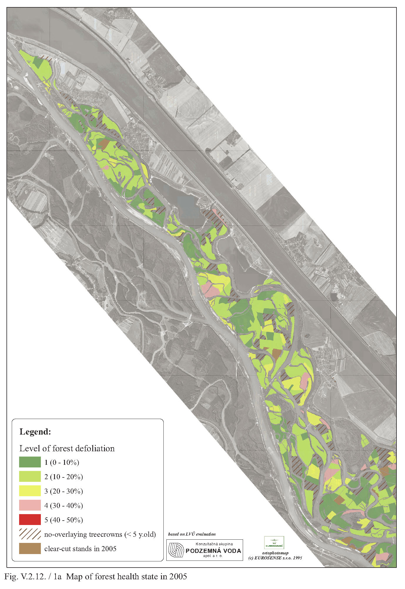
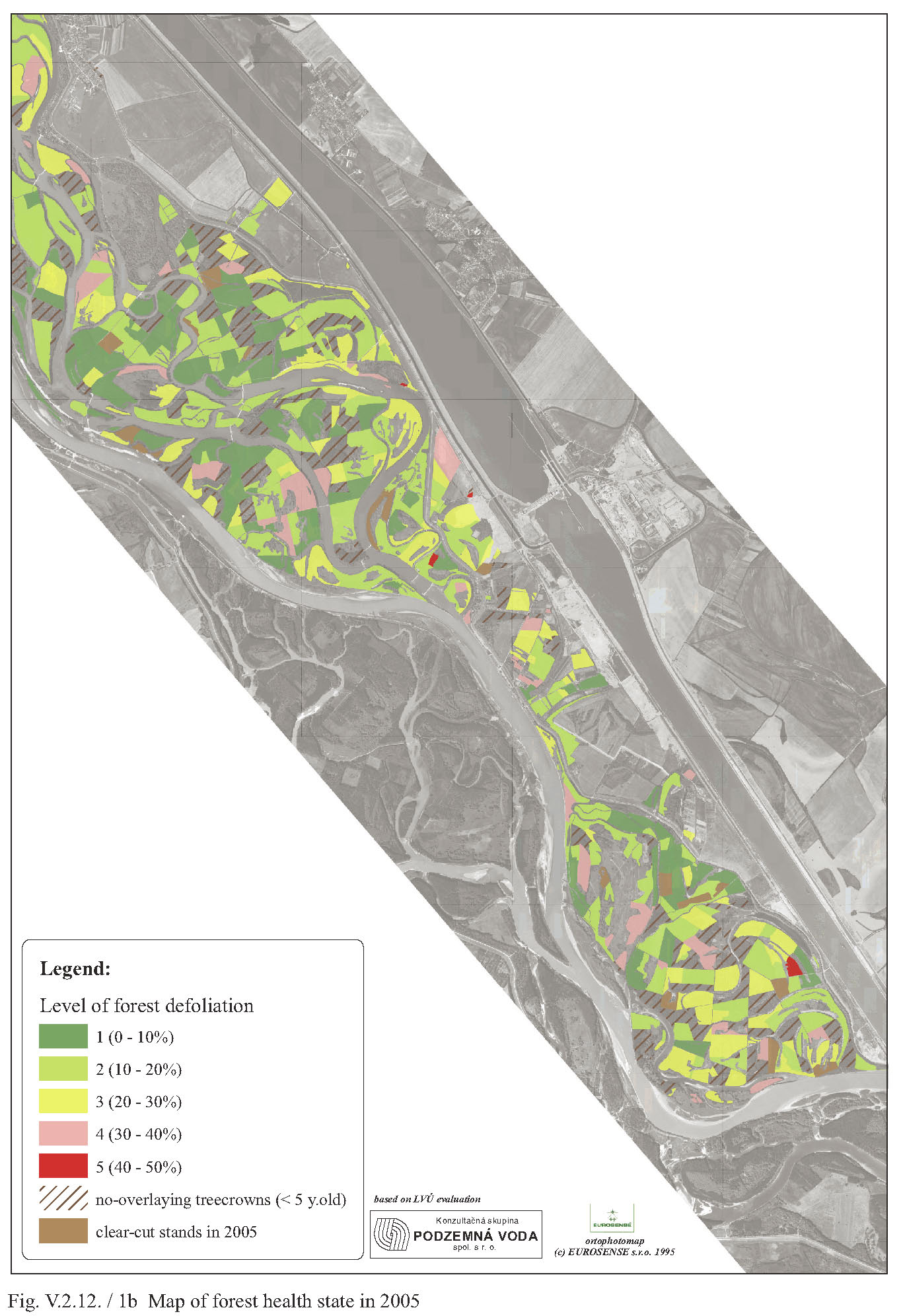
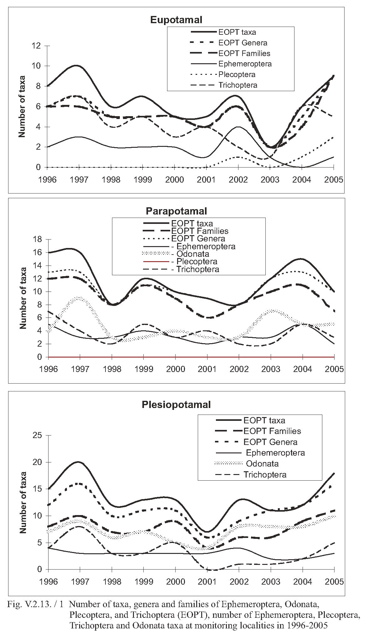
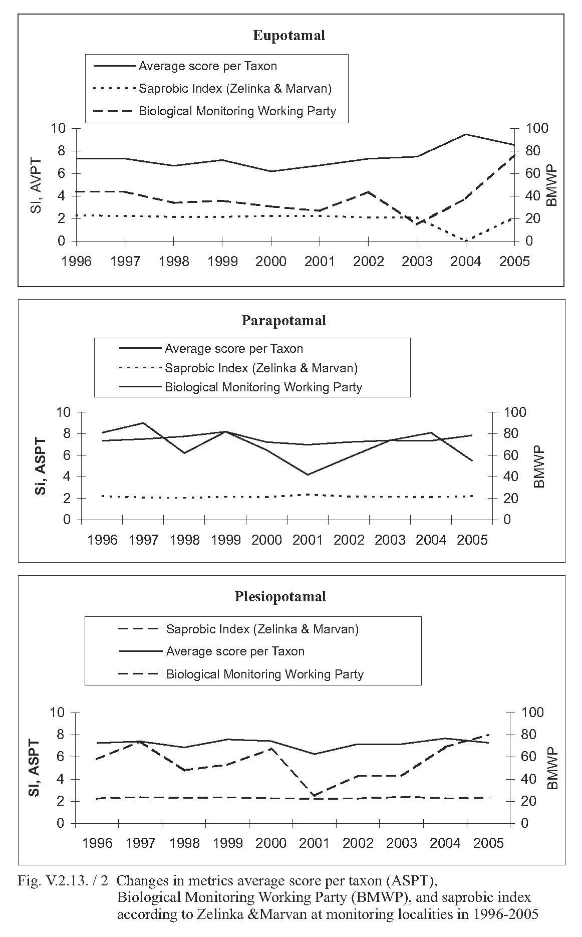
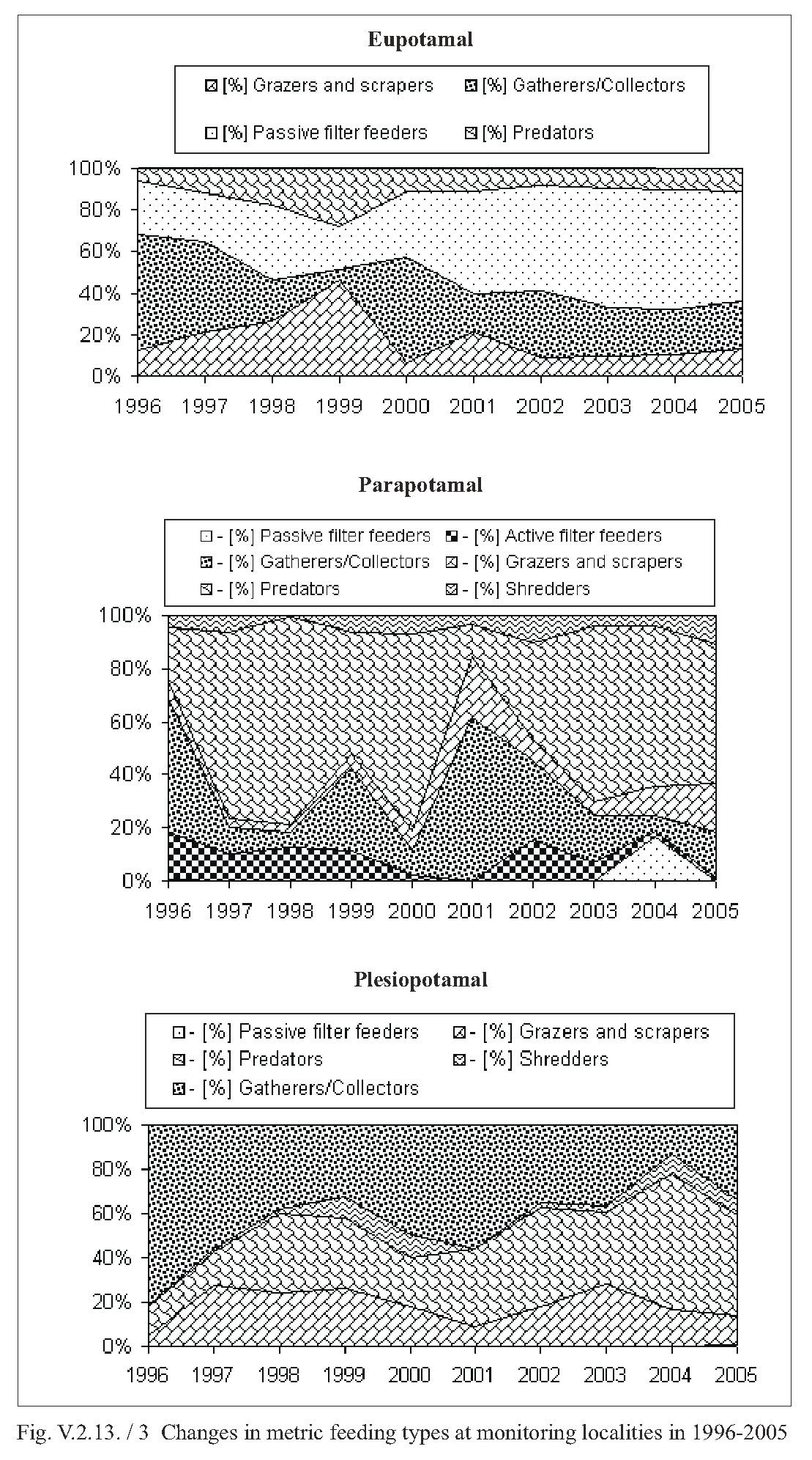
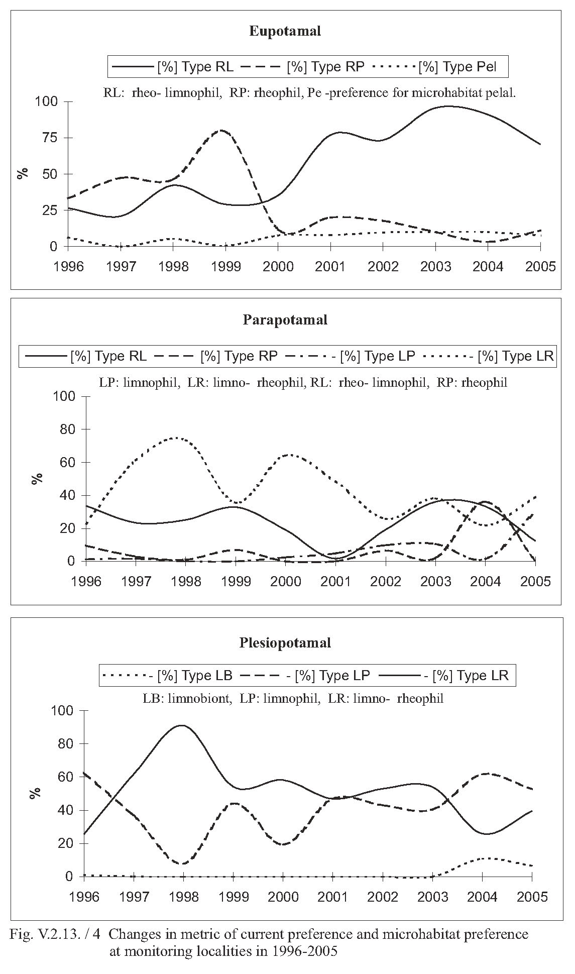