Anniversary of the Joint Slovak-Hungarian monitoring of natural environmentbased on 1995 Bilateral Agreement
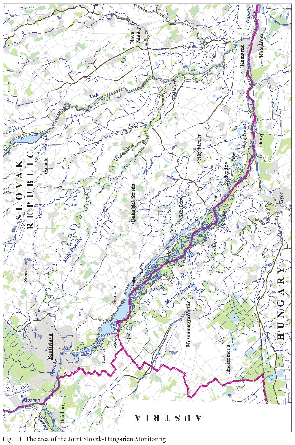
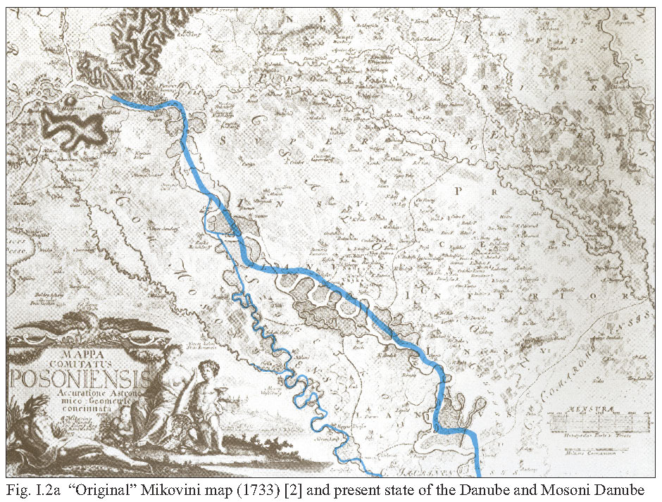
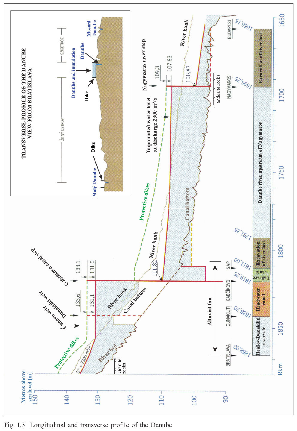
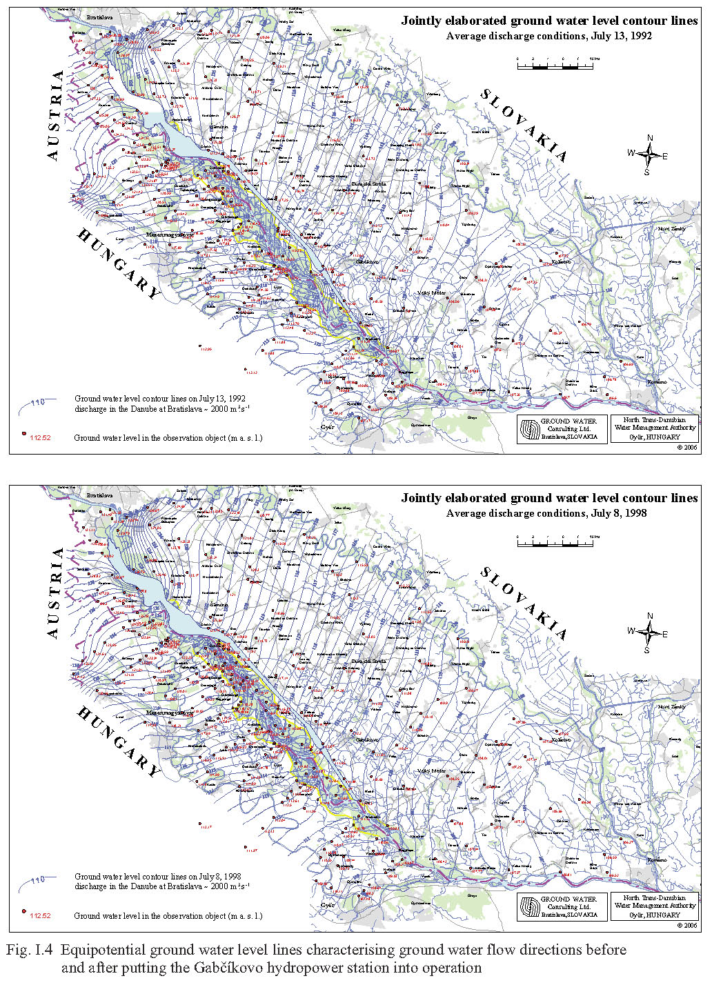
I. IntroductionDominik Kocinger The Danube has always played a vital part in commercial and economic development, making international co-operation essential. Improvements to the navigation channel have enabled the Danube, now linked by canal to the Main and thence to the Rhine, to become an important navigational artery connecting the North Sea to the Black Sea. In the stretch of river to which the Project relates, flood protection measures have been constructed over the centuries, farming and forestry practised, and, more recently, there has been an increase in population and industrial activity. According to Preamble of the Treaty 1977 “concerning the construction and operation of the Gabčíkovo-Nagymaros System of Locks”, the barrage system was designed to attain “the broad utilization of the natural resources of the Bratislava-Budapest section of the Danube river for the development of water resources, energy, transport, agriculture and other sectors of the national economy of the Contracting Parties”. The joint investment was thus essentially aimed at the production of hydroelectricity, the improvement of navigation on the relevant section of the Danube and the protection of the areas along the banks against flooding. At the same time, by the terms of the Treaty, the contracting parties undertook to ensure that the quality of water in the Danube was not impaired as a result of the Project, and that compliance with the obligations for the protection of nature arising in connection with the construction and operation of the system of Locks would be observed [9]. Work on the Project started 1978. On 13 May 1989, the Hungarian Government decided to suspend the works at Nagymaros. Lastly, on 27 October 1989, Hungary decided to abandon the works at Nagymaros and to maintain the status quo at Dunakiliti. On 7 April 1993, the Special Agreement for Submission to the International Court of Justice of the Differences Between the Republic of Hungary and the Slovak Republic Concerning the Gabčíkovo-Nagymaros Project was signed in Brussels. According to the Special Agreement, the Parties agreed that, pending the final Judgement of the Court, they would establish and implement a temporary water management regime for the Danube. After lengthy negotiations, the Parties finally concluded an Agreement concerning “Certain Temporary Technical Measures and Discharges in the Danube and Mosoni branch of the Danube”, on 19 April 1995. That Agreement raised the discharge of water into the Mosoni Danube to 43 m3/s. It provided for an annual average of 400 m3/s in the old bed (not including flood waters). It provided for construction by Hungary of an underwater weir near to Dunakiliti with a view to improving the water supply to the side arms of the Danube on the Hungarian side. Lastly, it provided for establishment of the Joint Slovak-Hungarian Monitoring of Natural Environment [1]. On April 19, 1995 the Government of the Slovak Republic and the Republic of Hungary signed an “Agreement between the Government of the Slovak Republic and the Government of Hungary about Certain Temporary Measures and Discharges to the Danube and Mosoni Danube” [1]. This Agreement has temporary character, pending the judgment of the International Court of Justice in the case concerning the Gabčíkovo-Nagymaros Project (Fig. Inside of the publication cover). The Embassy of the Republic of Hungary in Bratislava informed the Slovak ministry of foreign affairs on 12 December 1998 (note No. 348-1/1997), that the Government of the Hungarian Republic agrees with the proposal of the Government of the Slovak Republic to prolong the validity of the “Agreement” from 1995 until the conclusion of an Agreement between the Government of the Slovak Republic and the Republic of Hungary about the measures to implement the judgement of the International Court of Justice. The environmental monitoring activities being realised follow from the “Statute on the Activities of the Nominated Monitoring Agents”, as envisaged in the “Agreement”. The following evaluation is supported by jointly exchanged data from the environmental monitoring system operating in the area, by data that are necessary to impact assessment of the measures envisaged in Agreement [1], by data from state monitoring system and monitoring carried out in the framework of the Water authority decision. The area of the Joint Slovak-Hungarian Monitoring of Natural Environment based on the 1995 Bilateral Agreement is the area from Bratislava downstream to Komárno and from the Malý Dunaj (Little Danube) on the north to the Mosoni Duna (Mosoni Danube) on the south. The monitoring area includes the Old Danube riverbed and its left- and right-side floodplain with the Danube arm systems, and agricultural land of Žitný ostrov and Szigetköz (Fig. I.1). This area’s water regime is most impacted by the Gabčíkovo part of the project Gabčíkovo-Nagymaros. Inside this area lies a remnant of an original floodplain between the flood protection dikes on both sides of the Old Danube [2] (Fig. I.2a, Fig. I.2b). I. 1 Characteristics of the areaThe monitored area is situated in the central part of an intermountain depression, the Danube basin, called in Slovakia “Podunajská nížina” (Danubian Lowland). The basin consists of Late Tertiary (marine and lacustrine sand, fine sand, clay, sandstone and shale) and Quaternary sediments. Since the glacial Mindel epoch, these sediments are gravel and sand, deposited in the Danube alluvial fluvial and lacustrine conditions. The total depth of the Tertiary and Quaternary sediments reaches 8000 m. The Danube river sediments (since the Mindel epoch) form the main aquifer consisting of highly permeable gravels and sands with a hydraulic conductivity coefficient usually from 0.0001 up to 0.02 m.s-1. Its thickness ranges from a few meters at Bratislava to more than 450 m at Gabčíkovo. Further downstream, after the village Sap, their thickness decreases to several meters. Under this aquifer there is a complex of low permeable or almost impermeable older Quaternary and mainly Tertiary sediments. The important factors in the creation of the aquifer were the existence of the granite threshold between the Alps and the Carpathians in the area of Bratislava, and the predominantly andesite hard rocks between Štúrovo/Estergom and Nagymaros/Visegrád (Fig. I.3). These are the upstream and downstream geological boundaries and hydrological barriers, or literally natural dams, on the Danube. Upstream of the “natural dams” the Vienna basin and Danube basin come into existence, respectively. The hard rock barriers and tectonic subsidence of the basin determine the surface slope (Fig. I.3), the Danube River water flow velocities, and subsequently, the development of the so-called Danube Inland Delta. The Danube Inland Delta is an alluvial fan below the granite threshold at Bratislava, with its typical original morphology, i.e. branching of the Danube’s, changing river meanders, coarse sediment accumulations, changing river gradient, etc. This large alluvial fan consists of a highly permeable and extensive aquifer capable of carrying high volumes of ground water. The Danube flows on the top of this alluvial fan, which means, especially during the higher discharges, over the surrounding terrain (Fig. I.3). Water from the Danube therefore infiltrates into the fan alluvial sediments during all water stages on the river, and flows downward as ground water through the Danubian Lowland, nearly parallel with the Danube River (Fig I.4), and towards the Little Danube and Mosoni Danube. In the downstream part the river has a small slope, deposits are more fine-grained and generally less permeable. Here the ground water flows back into the Danube River via its own riverbed, the Little Danube, Mosoni Danube, the other Danube river arms, tributaries and drainage canals. Granite threshold, andesite threshold, and the place where the alluvial fan ends are all important points of significant changes in the natural conditions (on the alluvial fan end the river speed suddenly drops as its slope lessens from 40 to 10 cm per kilometre, Fig. I.3). These are the places where it has been proposed to situate the hydropower dams known as Wolfsthal, Nagymaros and Gabčíkovo, respectively. Pre-dam development Before the multiple impoundments in the upper Danube catchment areas, and the embankment and endikement in Austria, Slovakia, and Hungary, the Danube was a free flowing braided river with a wide flood plain that extended far beyond the present flood protecting dikes. Flow velocities may also have been much lower, as in the Danube in the pre Gabčíkovo dam conditions. With the history of endikements, especially during the 19 and 20 centuries, the Danube banks were fortified and flood protection dikes were built up on both sides. The straightened Danube channel flows between these dikes and across earlier meanders (Fig. I.2b). Flood peaks became steeper and higher. The original zoning in vegetation toward higher ground and associated forests was largely ‘diked’ out of the system. Most of the higher lying ground, behind the dikes, was converted into agricultural lands and no longer flooded. The area in between the dikes was consequently flooded more often and the river arms flushed and scoured more intensively. Free meandering was limited by the construction of fortified riverbanks. Interconnections between the river and its branches were limited. The main flow was concentrated into the previously straightened single river channel, later known as the main Danube. The reduced interaction with the side arms so created meant less flow. According to the experts of the Commission of the European Communities, (November 23, 1992) [3], flow in almost all river arms existed 17 days per year. Than as at present, high discharges in the Danube meant water overflows riverbanks and flooded the area between the protective dikes, the present inundation. This inundation – floodplain is highly valuable from an ecological viewpoint, and its original functions are worthy of preservation. Its irreplaceable functions include transferring of flood discharges, and acting as a natural polder moderating the maximal discharges during any flood. Both these functions are significantly manifested in reduced maximal discharges in the downstream stretches of the Danube. The area has favourable conditions for the growth of natural floodplain forests as well as for timber production. It is aesthetically attractive for tourists, and it also fulfils the self-purification function of the Danube water, because the arms have flowing water. Pre-dam activities have resulted in the following long-term changes:
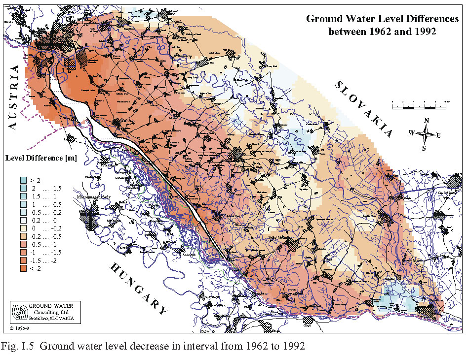
The considerable long-term decrease of ground water level [4, 5], which occurred in the last 30 years (before putting the Gabčíkovo part of the Project into operation), is evident mainly in the upper part of the Danubian Lowland, close to Bratislava (Fig. I.5). This pre-project decrease of ground water level over a long time had already negatively influenced natural conditions, mainly in the flood-plain area, and had negatively influenced agriculture, forestry and ground water resources. Comparison with the “original” historical state and present state can be seen from Mikovini map (1733) and superposition of present water bodies (Fig. I.2a, Fig. I.2b). Imre Dosztányi [6] originally made a similar comparison. This is the primary impulse to recover, at least partially, the “original” and historical spirit of the Danube, in the stretch between Dobrohošť and Sap. This idea is described and carefully justified from an ecological view point in the well known publication by Lisický, Mucha (eds.) [7, see also www.gabcikovo.gov.sk]. The main aim is to reconstruct the main eupotamal from the existing river branches (Fig. I.2b). This is also the reason why we are not supporting the rehabilitation of the fortified and straightened Old Danube River navigation canal [8]. The old Danube in the pre-Gabčíkovo project conditions was neither natural, nor a nature close stretch of the river. The main function of the Old Danube should be flood protection (carrying the main part of the flood discharges), creation of water bodies for water sport and recreation activities. This will be explained further. References
|