PART 6
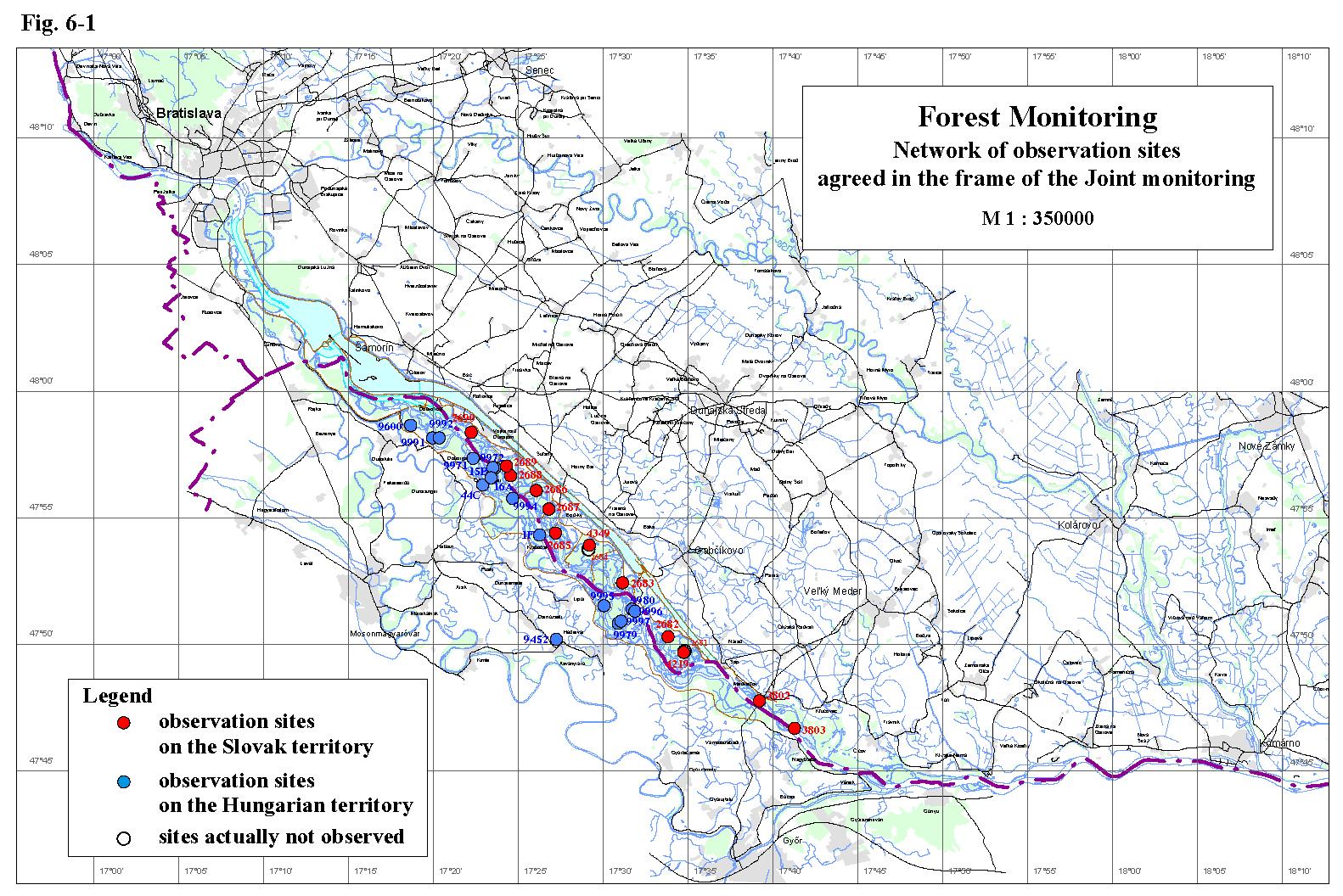
Forest MonitoringBoth countries examine the growth and the health state of forest stands in a similar way. Both the Slovak and Hungarian Parties in the present report evaluate the development of the basic growth parameters, weekly girth growth and the health state of trees in forest stands for the year 2004. Review of abiotic conditions in 2004, which essentially influencing the development of the forest communities (including fauna and flora evaluated in the Part 7 – Biological Monitoring), can be summarized as follows: the year 2004 was the second unfavourable year since 2002, when extraordinarily favourable moisture conditions were created thanks to occurrence of two strong natural floods, however the rainfall deficiency and the high air temperatures basically were not so distinct as in 2003. Comparing the monthly average temperatures the weather in 2004 was colder than in the period of last ten years. Moreover, March and May were colder in comparison with the data of last thirty years, and the amount of precipitation was higher as well. no flow rate occurred in 2004, which could evoke a significant increase of ground water level or which could flood a remarkable part of the inundation area. The ground water level was very low at the beginning of the vegetation period and stayed low and rather balanced during the whole year. artificial flooding of the inundation area was realised only in the right side inundation area; it was not realised on the Slovak side. 6.1. The Slovak territoryThe forest monitoring on the Slovak side is carried out on monitoring areas presented in table 6-1. All of them are situated in the inundation area (Fig. 6-1), where the most productive, rapidly growing wetland forest communities occur. These communities have high demand on water and have relatively high resistance to pests and pathogens. Table 6-1: List of the forest monitoring areas on the Slovak side
The monitored forest communities mostly represent the development of the stand conditions in different parts of the inundation area after putting the Gabčíkovo hydropower structure into operation. Monitoring areas No. 2683-2690 are situated in the region with controllable ground water level (between the intake structure at Dobrohošť and confluence of the Bačianske river arm and the Danube old riverbed). Specific conditions are created between the individual cross-weirs in the river branch system, depending on the ground water level position and thickness of the soil profile. The strip along the old Danube riverbanks has to be evaluated separately. Unfavourable moisture conditions are present in upper part of the inundation, up to the cross weir B (represented by the monitoring area No. 2690) and in the strip along the whole stretch of the Danube old riverbed (represented by monitoring areas No. 2689 and 2688). Lowering of the ground water level in the region upstream of the cross weir B reflects the long term gradual lowering of the Danube riverbed (last several decades) caused by riverbed erosion and dredging. The ground water remained low and fluctuates below the soil profile permanently after diverting the greater part of the flow rate to the power channel. The significant decrease of the ground water level and the absence of connection with the overlying soil layers occur due to the strong drainage effect of the Danube old riverbed. In general the development of the forest communities in these areas essentially depends on precipitation. Improving of moisture conditions can be expected after impoundment of the water level in the Danube old riverbed. Until then regular artificial flooding, supported by temporary increase of the water level in the Danube old riverbed is necessary. The necessity of artificial flooding is confirmed by monitoring results from the region between the cross weir B and E (monitoring areas No. 2686 and 2687). The connection between the ground water level and the soil profile in this region is mostly created during floods. However, the unfavourable impact of the lowered ground water level is mitigated by the big thickness of the soil profile. The region from the cross weir E to the estuary of the river branch to the Danube old riverbed (represented by monitoring areas No. 2685, 2684, 2683 and 4349) is characteristic by permanent connection of the ground water level with the soil layers. In spite of this, there is proved the positive influence of floods in this region as well. In last years slight gradual decrease of moisture in the soil horizons was detected in this region (similarly to the whole inundation area), which is eliminated by flooding. The region with uncontrollable ground water level is situated downstream from the mouth of Bačianske river arm till the confluence of the Danube old riverbed and the tailrace channel. Monitoring areas No. 2681, 4219 and 2682 represents this region. This area is flooded in the consequence of the backwater effect from the confluence of the Danube old riverbed and the tailrace channel, however floods last shorter due to the deepening of the riverbed. In years with frequent or longer lasting occurrence of low flow rates accompanied by rainfall deficiency the soil layers moisture content significantly decreases. The ground water level decrease is caused by riverbed erosion downstream of the confluence. Since years 2003 and 2004 were characteristic by such conditions the results confirmed the necessity of solving the water supply for this region. The model monitoring areas No. 3802 and 3803 are situated in the region downstream of the confluence of the tailrace channel and the Danube old riverbed, where direct influence of the Gabčíkovo hydropower structures were not expected. The ground water level in this region develops according to the actual hydrological situation on the Danube, however, in last years ground water level decrease is registered. This decrease is connected with the riverbed erosion downstream the confluence of the tailrace channel and the Danube old riverbed, as well as with the dredging due to navigational requirements in the stretch situated downstream. In spite of the abovementioned significant differences in abiotic conditions in general it can be stated that according to results obtained on monitored areas the height increases on large part of the inundation was still good in 2004, regardless the high age of trees and the absence or short connection of the ground water with soil layers. It could be explained by penetration of roots into deeper parts of soil and gravel layers to reach the lowered ground water level. It is supposed that the growth characteristics would be worse in young stands, which will be planted in the future because of their undeveloped root system. The girth growth increments decreases in last years, however the high age of trees can play an important role. The slow girth growth in 2004, without distinct growth peaks reflects the absence of floods and balanced course of the ground water level during the whole vegetation period. Although the meteorological conditions in 2004 were favourable for spreading of fungicidal or bacteriological illnesses, their slightly increased occurrence was registered at the end of vegetation period only. This could not influence the production characteristics. 6.2. The Hungarian sideThe forest monitoring on the Hungarian side in the year 2004 was carried out on monitoring areas presented in Table 6-2. All of them, except the monitoring area No. 9452 at Hédervár, are situated in the inundation area (Fig. 6-1.). The forestry observations in 2004 included the measurement of the wood yield and increase of girth of selected individuals as well as the tree health state observation. Table 6-2: List of the forest monitoring areas on the Hungarian side
According to dendrometric measurements in 2004 it can be stated that the changed moisture conditions in the Szigetköz region after diversion of the Danube slightly affected the older poplar stands “I-214” and “Pannonia” with outstanding capabilities and middle aged stands, which are situated in a good habitat, however sensitively affected stands, which are situated on unsuitable locations for poplars. In case of willows, the growth rate on monitoring areas with younger stands can be still considered as favourable. However, the slower growth rate of 13-14 years aged willows is unfavourable. The growth rate of these stands is supposed to culminate between 20-25 years. In general it can be stated that conditions for willow cultivation in Szigetköz became noticeably worse. The girth increment rate of poplar clones in the observed region stagnated, however in comparison with the results from 2003 it can be stated that in the actual year slight increase was registered. The girth growth of willows for the entire year was similar to the previous period, however its rate was lower than the expectable values. The changed hydrological conditions besides the growth parameters influenced the health state of forest stands. Generally it can be stated that the health state of trees in 2004 showed some stabilisation. The impact of the Danube diversion mostly affected willow stands. The health state of willows in 2004 was medial, with occurrence of dry branches. Significant worsening of the willow tree health state can be observed in the region upstream Dunasziget and Kisbodak villages. With the current water supply, and due to the high calcium content in soils and the high location of willow stands most of sites became not suitable for willow growth. Willows along the Danube riverbank dried up in previous years, but the state of the remaining individuals became better in last years. The health state of poplars showed was stagnant or better in the year 2004. The bark infection of poplars was rare, premature defoliation was minimal. The dominance of Urtica dioica registered in the previous year decreased in 2004.
|
|
|
Fig. 6-1 Monitoring network of observation objects
agreed in the frame of the Joint monitoring |