PART 6
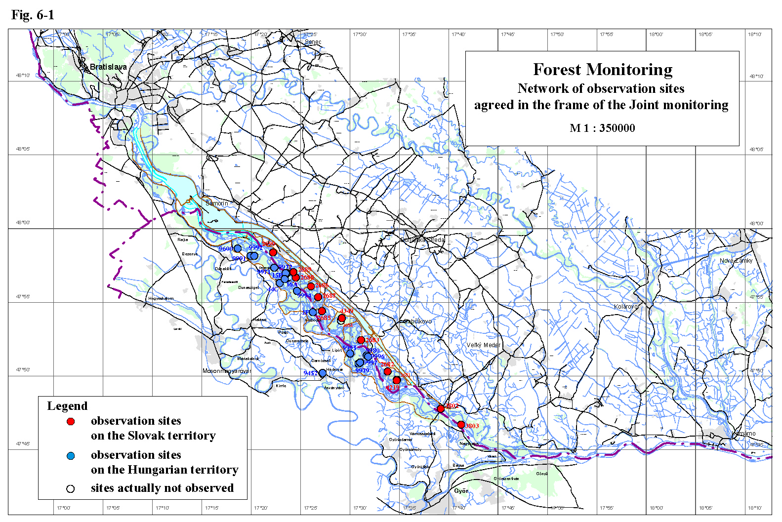
Forest MonitoringBoth countries examine the growth and the health state of forest stands in a similar way. Monitoring sites on the Slovak and Hungarian territories, included in the joint monitoring, are shown on Fig. 6-1. Both the Slovak and Hungarian Parties in the present report evaluate the development of the basic growth parameters, weekly girth growth and the health state of trees in forest stands for the year 2003. The Hungarian Party in its National Annual Report performed an analysis of aerial photos taken in 2002 and 1991 with an accent on changes in the extent of forest area on the right side of the river. The atypical flow rate regime of the Danube and unfavourable climatic conditions influenced the development of the tree stands in 2003. The detailed review of abiotic conditions is given at the beginning of Part 7- Monitoring of Biota. The forest monitoring on the Slovak side is carried out on monitoring areas presented in table 6-1. All of them are situated in the inundation area (Fig. 6-1), where the most productive, rapidly growing wetland forest communities occur. These communities have high demand on water and have relatively high resistance to pests and pathogens. Table 6-1: List of the forest monitoring areas on the Slovak side
The monitored forest communities mostly represent the development of the stand conditions after putting the Gabčíkovo hydropower structure into operation in different parts of the inundation area. Monitoring areas No. 2683-2690 are situated in the region with regulated ground water level (between the intake structure at Dobrohošť and confluence of the Bačianske river arm and the Danube old riverbed). Specific conditions between the individual cross-weirs in the river branch system are created, depending on the ground water level position and thickness of the soil profile. Presence of unfavourable moisture conditions was confirmed in the region of Dobrohošť, upstream of the cross-weir B (represented by the monitoring site No. 2690), due to the shallow soil layer. Although the soil moisture depends mostly on climatic conditions, increase of soil moisture values are observed during realisation of artificial floods. The development of forest communities on monitoring sites No. 2689 and 2688 is affected by specific conditions in the strip along the Danube old riverbed, where drainage effect strongly appears. The ground water level usually fluctuates in the gravel layer during the greater part of the vegetation period and in 2003 it fluctuated in the gravel layer only. Forrest communities under such conditions in fact depend on precipitation. The precipitation ensures favourable moisture conditions for development of wetland forest thanks to the excellent retention ability of soils. However, in case of repetitional occurrence of dry periods, as it occurred in 2003, damage of forest communities can be expected without water level increase in the Danube. This is confirmed by not fully successful reforestation of the area No. 2689. In other parts of the region with regulated ground water level favourable water supply of forest stands can be confirmed. Positive impact of artificial or natural floods can be proved as well. Earlier increase of discharge into the left side river branch system could further improve the moisture situation at the beginning of the vegetation period. The best time from the forest development point of view seems to be the beginning of March, before the vegetation period and intensive forest transpiration start. During the vegetation period the immediate evaluation of soil moisture measurements could help in operational changing of the discharge and water level regime in the river branches, or even it could operatively signalize the need of artificial flooding of the area. The region with unregulated ground water level is situated downstream from the mouth of Bačianske river arm till the confluence of the Danube old riverbed and the tailrace channel. Monitoring areas No. 2681, 4219 and 2682 represents this region. Moisture conditions in this region are mostly favourable, the soil moisture is generally supplied from the ground water level. The ground water level is more favourable during higher flow rates in the Danube, full saturation of soils occurs. This phenomenon, thanks to the excellent retention ability of soils, has a long-time effect. Unfavourable hydrological conditions in 2003 (the long lasting average and low water period in the Danube) proved the need of solving the water supply of this region. Besides this the moisture conditions were further deteriorated by long lasting dry and warm period in summer 2003. The model monitoring areas No. 3802 and 3803 are situated in the region downstream of the confluence of the tailrace channel and the Danube old riverbed. Direct impacts of the Gabčíkovo hydropower structures were not proved in this region, moisture conditions of biotopes are very favourable. However, the smallest soil moisture content of the whole observed period were registered in the year 2003, due to the extremely low flow rates in the Danube. Two strong natural floods, at the beginning and at the end of the vegetation period in 2002, were the main factors influencing the development of vegetation. Long lasting dry and warm period and simultaneous low flow rates in the Danube were characteristic for the vegetation period in 2003. These unfavourable meteorological and hydrological conditions were reflected on the growth and the health state of forest stands on most of observed areas. The growth of poplars “I-214” and “Robusta” in the region with regulated ground water level is continually adequate; growth of trees corresponds to curve of the absolute quality class of 36-40, although they are behind their growth culmination. The girth growth of trees was relatively even throughout the whole vegetation period, which points out the absence of natural or artificial flooding of the inundation area in 2003. More frequent occurrence of zero weekly increments on several poplar stands, which were recorded during the previous year, has not repeated. Gradual spreading of the newly cultivated clone “Pannonia” is registered in the inundation area. It is planted on areas after cut out of the original monitoring stands. Evaluation of some of these young stands will start in the following year. According to the evaluation of the health state of this clone no significant deteriorating can be notified in the region. Decrease of resistance to leaf damagers was registered on every present clone in 2003 due to the dry and warm vegetation period. Spreading of fungicidal illnesses was restricted. On the other side the climatic conditions evoked premature defoliation in several regions – particularly the region at Dobrohošť (area No. 2690) and the strip along the Danube old riverbed (areas No. 2688, 2689) where the drainage effect strongly occurs. Actually the older stands don’t show damage signs due to the water insufficiency, however, this phenomenon will probably cause problems at reforestation of these stands. This is already indicated by not fully successful reforestation at monitoring area No. 2689. The growth and the health state of poplar “Robusta” in the region with unregulated ground water level, upstream of the confluence of the Danube old riverbed and the tail race channel, was adequate as well. This region is characteristic with positive impact of backwater effect and regular presence of floods, however the long lasting period of low flow rates in the Danube in 2003 influenced this region negatively. This is demonstrated by unsuccessful reforestation of the monitoring area No. 2681 by cultivated white willow, what emphasizes the need of solving the water supply of this region. The forest monitoring on the Hungarian side in the year 2003 was carried out on monitoring areas presented in Table 6-2. All of them, except the monitoring area No. 9452 at Hédervár, are situated in the inundation area (Fig. 6-1). The forestry observations in 2003 included the measurement of the wood yield and increase of girth of selected individuals as well as the tree health state observation. Table 6-2: List of the forest monitoring areas on the Hungarian side
According to the wood yield measurements in 2003 it can be stated that poplar stands “I-214” and “Pannonia”, which occurs in stands ideal for poplars, were able to reach much higher growth rate than correspond to the relevant forest yield charts. However, in line with the growth data since diverting the Danube, the changed environmental conditions slightly affected the older stands with outstanding capabilities and the middle-aged stands enjoying good habitat, but sensitively affected the stands situated on unsuitable locations for poplars. In case of willows, the growth rate on monitoring areas with younger stands can be still considered as favourable. However, taking into account the slower growth rate of willows, it is unfavourable that the growth rate of 13-14 years old stands has decreased, although the growth of these stands is supposed to culminate between 20-25 years. In general it can be stated that conditions for willow cultivation became noticeably worse. According to the weekly girth increments the girth growth of poplar clones was slow in last years, although their yearly height growth was suitable. Similarly to previous years two peaks were registered in the girth growth of tree on Hungarian side, which were followed by a small one at the end of the vegetation period. The first peak occurred at the end of May, which was followed by stagnation during June. This corresponds to a dry period with high temperatures and soil moisture decrease. The second peak is bounded to beginning of July, when higher amount of rainfall moisturized the soils. The growth of willows for the entire year was similar to the previous period, however its rate was lower than the expectable values. The changed hydrological conditions besides the growth parameters influenced the health state of forest stands. The impact of diverting the Danube is mostly present on willow stands. The health state of willows shows remarkable deterioration in the region upstream Dunasziget and Kisbodak villages in 2003. With the current water supply, and due to the high calcium content in soils and the high location of willow stands, along with missing floods, most of sites became not suitable for willow growth. Few willow along the Danube riverbank dried up in previous years, but the state of the remaining individuals became better in last years. The health state of poplars showed improvement in the year 2003. The bark infection of poplars was rare, premature defoliation was minimal. The herb layer is a good indicator of biotope moisture conditions as well. In spite of the drought in 2003 the undergrowth reached higher values in comparison with the previous year, when two big floods influenced the development of vegetation. The species composition changed in favour of nettle, which appeared everywhere in large volume and reduced spreading of other species. Spreading of the invasive Impatiens glandulifera was lower. The comparison of aerial surveys of the inundation area performed in 1991 and 2002 was done within the framework of analysing and evaluating the health condition of the alluvial woods of Szigetköz. According to this comparison the wooded area of Szigetköz grew. This increase reflects the net change of extension of the bush-willow stripes along the Danube old riverbed and the decrease of the forest area in the inundation area. Concerning the evaluation of the health state, the Hungarian side has the opinion, that under the present conditions, neither the automated picture processing used in 2002, nor the visual one, tried out in 2003, is suitable for unambiguous appraisal of the health conditions changes of the region’s forests. According to the Hungarian side the use of field investigations seems to remain the most important method for the health conditions.
|