PART 6
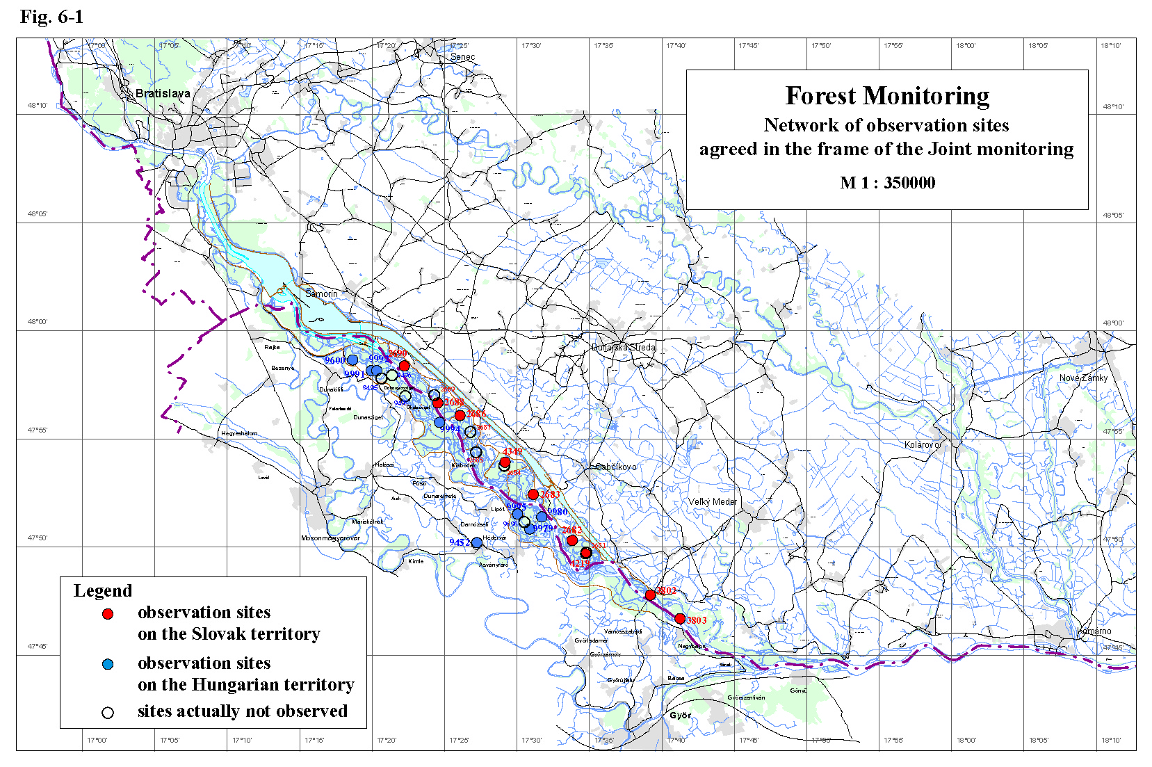
Forest MonitoringBoth countries examine the growth and the health state of forest stands in similar way. Monitoring sites on the Slovak and Hungarian territories, included in the joint monitoring, are shown on Fig. 6-1. Both, the Slovak and Hungarian Parties in the present report evaluate the development of the basic growth parameters, weekly girth growth and the health state of trees on forest stands for the year 2002. In this year the Hungarian Party in its National Report evaluated the yearly wood yield data also for the actual year. So, in difference to the previous years, there was no delay in comparison to the all other evaluated data. In 2002 aerial survey of the health state of forest stands in the Danube left side inundation area (Slovak territory) was performed. The results of the evaluation are shown in the present report. The aerial survey of the right side inundation area (Hungarian territory) was not performed in the year 2002. However, the Hungarian side did some evaluation of the 1999 aerial survey in this year and short results are presented in this report as well. 6.1. The Slovak territoryThe forest monitoring on the Slovak side is carried out on monitoring areas presented in table 6-1. All of them are situated in the inundation area (Fig. 6-1), where the most productive, rapidly growing wetland forest communities occur. These communities have high demand on water and have relatively high resistance to the biotic harm. Table 6-1: List of the forest monitoring areas on the Slovak side
The monitored forest communities represent the development of the stand conditions after putting the Gabčíkovo hydropower structure into operation in different parts of the inundation area. Monitoring areas No. 2683-2690 are situated in the region with regulated ground water level (between the intake structure at Dobrohošť and confluence of the Bakanské river arm and the Danube old riverbed). The water supply into the river branch system introduced in 1993 significantly eliminated the ground water level decrease, expected after damming the Danube. Specific conditions between the respective cross-weirs in the river branch system are created, depending on the ground water level position and thickness of the soil profile. Presence of unfavourable moisture conditions is confirmed in the region of Dobrohošť, upstream of the cross-weir B (represented by the monitoring site No. 2690). The development of forest communities on monitoring areas No. 2689 and 2688 is affected by specific conditions in the strip along the Danube old riverbed, where the drainage effect strongly appears. The ground water level fluctuates in the gravel layer during greater part of the vegetation period. Forest communities in fact depend on precipitation, which significantly helps in ensuring favourable moisture conditions for development of wetland forest thanks to the excellent retention ability of soils. The region with unregulated ground water level is situated downstream from mouth of the Bakanské river arm till the confluence of the Danube old riverbed and the tailrace canal. Monitoring areas No. 2681, 4219 and 2682 represents this region. Impacts of the ground water level decrease (in case of low flow rate in the Danube) after putting the Gabčíkovo hydropower structure into operation are in this region less significant thanks to the backwater effect and good retention ability of soils. Moisture conditions in this region are very favourable. The model monitoring areas No. 3802 and 3803 are situated in the region downstream of the confluence of the tailrace canal and the Danube old riverbed. Direct impacts of the Gabčíkovo hydropower structures were not proved in this region, moisture conditions of biotopes are very favourable. The two extreme natural floods, at the beginning and at the end of the vegetation period in the year 2002, positively influenced the development of forest communities in the whole monitored region. The basic growth parameters at the newly planted white willow stand, sp. “Gabčíkovo 9”, on the monitoring site No. 2681 were not evaluated in the year 2002. The health state of the planted clone was good; occurrence of illness and biotic harm was not recorded. The weekly girth growth measurements are temporarily performed in the neighbouring stand No. 4219 since 2001. The obtained results prove the permanent favourable hydrologic conditions in this region, however a zero weekly increments were rather often recorded during the dry period (May-July 2002). Maximal increments are concentrated in the first third of the vegetation period, which was generally characteristic for the year 2002 because of plenty of moisture in the soil after the flood in March 2002. The ratio of individual poplar clones in the Danube inundation area has changed in previous years. Cut areas are mainly planted with the newly cultivated resisting clone Populus x euroamericana “Pannonia”. Monitoring of dendrometric characteristics at these newly planted stands on original monitoring sites will start within a few years. Based on forest monitoring upstream of the confluence of the Danube old riverbed and the tailrace canal in year 2002 it can be stated that the present poplar stands of Populus x euroamericana “Robusta” and Populus x euroamericana “I-214” henceforth show high values of growth parameters. The growth of the trees corresponds to curve of the quality class 40 (former quality class I) and the average height and girth increment values decreasing very slowly in spite of the high age of stands. However, in comparison to the previous year the weekly girth growth increment values on some areas were lower. During the dry period (May-July 2002) more frequent occurrence of zero weekly increment values were recorded on some poplar stands too. According to the terrestrial observations the health state of the trees is satisfactory and stable. The growth of the young stands of Populus x euroamericana “Pannonia” and Populus x euroamericana “Giant” on the model sites L-25 a L-26 is very intensive. The newly cultivated clones show high resistance from the health state point of view. Based on the aerial survey, performed in the year 2002, the health state of the forest stands between the original Danube riverbed and the bypass canal can be classified as very good. Classification of the health state according to tree defoliation does not proved the negative impact of the Gabčíkovo hydropower structure on forest communities. The average defoliation of forest stands in influenced area show decreasing tendency in the observation period (1996-2002). The values were lower than the Slovak average value of greenwoods defoliation. In the monitored period increase of areas with healthy forest and forest with very slight signs of damage was recorded. Decrease of areas with slightly damaged and medium damaged forests (with defoliation 20-50%) was recorded. Most of the damaged stands are situated in the region of Dobrohošť. The results of the monitoring in the year 2002 prove the positive impact of natural floods. According to this it can be concluded the necessity of realisation of artificial floods (in case of absence of natural floods) with simultaneous support of water level increase in the Danube old riverbed in following years. Damage of some regulation objects in the river branch system occurred during the flood in March 2002. The dry period (May-July 2002) proved the needs of fast repairing of damages and returning the functionality of the river arm system to be able improve moisture conditions by artificial flooding of the inundation area. The immediate evaluation of soil moisture measurements can help in flexible changing of the flow rate and water level regime in the river branch or even it can operatively signalise the needs of artificial flooding of the area. 6.2. The Hungarian sideThe forest monitoring on the Hungarian side in the year 2002 included measurements of the yield, weekly girth growth increments of selected individuals and observation of the health state of forest stands. The monitoring was carried out on monitoring areas presented in Table 6-2, which, except one, are situated in the inundation area (Fig. 6-1.). According to the Agreement of experts, signed on June 17, 2002, cleared monitoring stands will be substituted by existing or new observation areas during the year 2003. The substitution will be done after a field observation and common approval of the experts of both Parties automatically. This approach will be applied also in the future. The evaluation in this Joint report includes results of forest monitoring from the year 2001 and 2002. By this step it is ensured, that the yearly increment data represent the actually evaluated year (unlike to the previous existing practice, when the yearly increment data described the development in the previous year). The monitoring results obtained in the year 2001 and 2002 were similar. The natural floods at the beginning and at the end of the vegetation period positively influenced the development of forest communities on the Hungarian side too. However, the climatic conditions and the distribution of precipitation during the vegetation period were very unfavourable for vegetation. The precipitation distribution was uneven, sometimes substantially deviating from long-term averages. There were a little precipitation in January, April and especially in May and June, and a lot of felt down in August. The sum of precipitation in the vegetation period was 30 % less than the average. The length of the growth period was average in the year 2002; its duration was 21 weeks. Table 6-2: List of the forest monitoring areas on the Hungarian side
The growth rate of the trees, represented by the yearly growth increments data, indicates that trees in the Szigetköz region were influenced by ground water level decrease after diverting the Danube. A considerable decrease was recorded. After introducing the water supply into the inundation area in 1995 the negative impacts of the water level decrease was significantly reduced. The ground water level increased, and on great part of the area is constantly situated in the soil layer. However, measures realised according to the Agreement have not solved the water supply of the forest stands situated along the Danube old riverbed. Especially stands along the Danube planted by willows, which are very water demanding, became unsuitable for willows. Actual situation is favourable for cultivated poplars, but it is not sufficient for willow stands, which require occasional flooding. Present observations document that intensive growth of more plentiful poplar clones is going on till age of 12-13 years. The growth of elder trees lags behind the growth rate before damming the Danube by app. 7-8 % and does not reach the level recorded in the period before damming the Danube. On the other side the positive influence of the improved hydrologic conditions after introducing the water supply is evident. The growth parameters of the poplar stand on the monitoring area Dunasziget 44C was excellent. However, the yearly increments of willow stands are still very low. The growth of the mixed oak stand is stable. Changed hydrological conditions besides the growth parameters influenced the health state of forest stands. Impact of diverting the Danube is mostly present on willow stands. The health state of willows was moderate in the year 2002, but it shows remarkable deterioration in the region upstream Dunasziget and Kisbodak villages. In spite of the water supply due to the high calcium content in soils and due to the high location of willow stands, along with missing floods, these stands became not suitable for willow growth. Few willow along the Danube riverbank dried up in previous years, but the state of remaining individuals became better in last years. The health state of poplars show continues improving in the year 2002. The damages caused by biological factors remained on the level of previous years. However, the dotychiza infection was more frequent. The herb layer is a good indicator of biotope moisture conditions as well. The inundation area was twice flooded in the year 2002; therefore the size of the herb layer was large too. Based on the results of evaluation of the aerial survey of the inundation area performed in the year 1999 the Hungarian side concluded:
The presented evaluation does not contain conclusions about the health state of forest stands in the right side inundation based on the defoliation of trees.
|