PART 6
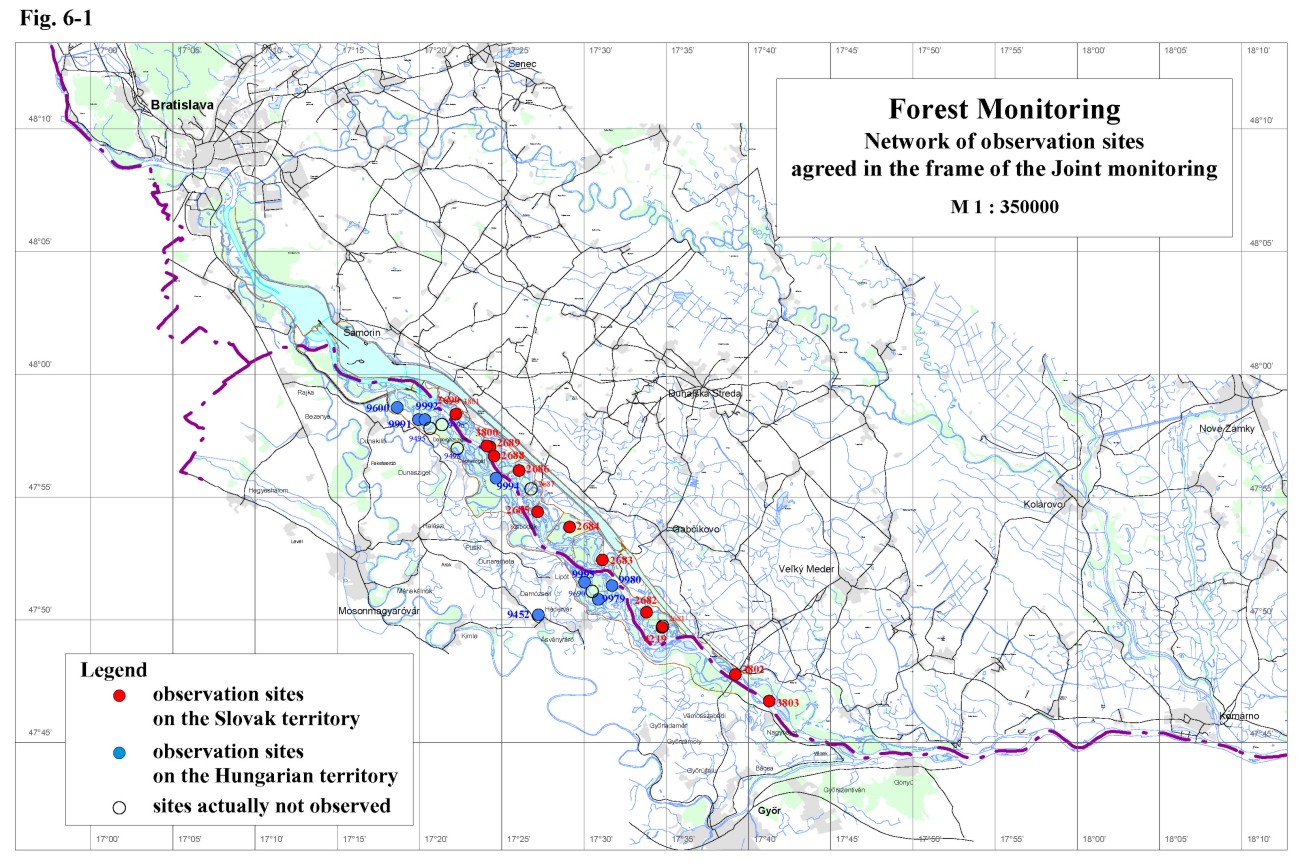
Forest MonitoringBoth countries examine the growth and the health state of trees on forest stands in similar way. Monitoring sites on the Slovak and Hungarian territories, included in the joint monitoring, are shown on Fig. 6-1. Both, the Slovak and Hungarian Parties in the present report evaluate the weekly girth growth as well as the health state of trees on forest stands for the year 2001. In the evaluation of the yearly wood yield data the Hungarian Party use only the data for the year 2000. In 1999 an aerial survey of the forest health state in the inundation area was performed. The evaluation of the aerial photographs from the Slovak side was finished in 1999 and it was presented in the Joint Report in 2000. Evaluation of the aerial photographs from the Hungarian side, which started at the end of 2001, still continues.
6.1. The Slovak territoryThe forest monitoring on the Slovak side is carried out on monitoring areas presented in table 6-1. All of them are situated in the inundation area (Fig. 6-1), where the most productive, rapidly growing wetland forest communities, occur. These communities have high demand on water and have relatively high resistance to biotic harm. Table 6-1: List of the forest monitoring areas on the Slovak side
The forest stands were considered as the most endangered after construction the Gabčíkovo hydropower structure, but these assumptions were not confirmed. The ground water level decrease, detected after diverting the large part of discharge into the power channel was eliminated on a considerable part of the inundation area by the water supply through the intake structure at Dobrohošť and by a set of cross weirs in the river branch system. This situation relates to monitoring sites L-3 to L-12, except sites L-11 and L-11a, where unfavourable situation occurred due to the strong drainage effect of the Danube old riverbed. The ground water level along the Danube dropped down and mainly fluctuates in the gravel layer. Unfavourable moisture conditions will be probably observed on the newly planted poplar stand on monitoring site L-11. Raising the water level in the Danube by appropriate underwater weirs could influence negative effects of the Danube drainage on the monitoring areas lying close to the riverbed. The situation is favourable from the ground water level point of view at monitoring site L-3, L-3a and L-4, where the backwater effect influencing the ground water level position. The monitoring sites L-25 and L-26 are situated downstream of the confluence of the tailrace canal and the Danube old riverbed, and the Gabčíkovo hydropower structure is not influencing these forest stands. The white willow stand on the monitoring site L-3 was cut out in 2001, however the weekly girth growth measurements have been performed in the neighbouring equally aged willow stand L-3a, which had similar conditions. The results prove the permanent favourable conditions in this region. The measured increments were comparable to the increments of previous years. The same willow clone “Gabčíkovo 9” was planted on the original monitoring site L-3 and the observation will continue on this new willow stand. Great part of monitoring sites is planted by cultivated poplar stands – Populus x euroamericana Robusta and Populus x euroamericana I-214. Based on observation results in 2001 it can be generally stated that increments of trees in spite of their ages is permanently very good and decreasing very slowly. The tree height increment corresponds to curves of the I. growth class. The weekly girth growth values usually had two culminations. The first one occurs at the beginning of the vegetation period, when the trees have used the moisture accumulated in the winter period. The positive impact of the artificial flooding was proved by the second culmination of girth growth values, after realising the artificial flooding. Decreased resistance of the poplar “Robusta” against the biotic harm (mainly against the Erwinina cancerogena) occurred in 2001 again. The same phenomenon occurred on the other region of Slovakia. The health state of the observed stands in general was comparable with the previous years, and the occurrence of biotic harm was generally slight. Damages caused by abiotic factors were no recorded in 2001. Monitoring areas L-25 and L-26 are situated downstream the confluence of the tailrace canal and the Danube. This region is characteristic by very favourable moisture conditions, which reflected in growth increments of young trees. The height and diameter increment of the newly cultivated poplar clones – Populus x euroamericana Pannonia and Populus x euroamericana Giant are tremendously intensive. Looking at the health state of these stands, it can be stated that these clones are characteristic by very high resistance.
6.2. The Hungarian sideThe forest monitoring on the Hungarian side in the year 2001 was carried out on twelve monitoring areas (Tab. 6-2), which, except one, are situated in the inundation area - Fig. 6-1. The yearly increments of the year 2000 on monitoring areas presented in the table 6-2 were measured at the beginning of the year 2001. The obtained data represents the development of the forest stands in the year 2000. On selected areas weekly girth growth measurement was performed as well. Similarly to the Slovak side observation of the health state of forest stands was carried out too. The moisture conditions in the year 2001, taking into consideration the total amount of precipitation, were favourable, however its distribution in the vegetation period were not. Table 6-2: List of the forest monitoring areas on the Hungarian side
The yearly growth increments data indicate that the forest stands in the Szigetköz region were influenced by the ground water level decrease after damming the Danube. The negative impact of the Danube old riverbed strong drainage effect was decreased after introducing the water supply ensured by the underwater weir. However, the measures realised according to the Agreement have not solved the water supply for the forest stands situated along the Danube old riverbed. Especially stands along the Danube planted by willows, which are very water pretentious, became unsuitable for willows. Regarding the poplar stands the situation is more favourable. However, a slight decrease of increment occurs, but stabilisation of the observed characteristics is expected. The average growth period was 21 weeks in 2001. In general the abiotic conditions were favourable for poplars. The weekly girth growth data did not show changes in comparison with the previous year; however on some places greater increments could be expected in the young forest stand. The development on willow stands was comparable with the development in previous years, the increments on monitoring sites along the Danube lag behind the expected values. Regarding the long-term development it can be stated that there was a significant decrease of increments observed in 1993 and 1994, after damming the Danube, when no or very small amount of water was supplied into the river branch system. The hydrologic conditions became better after introducing the water supply in 1995 according to the Agreement. The water supply resulted in considerable increase of ground water level, which continuously stay in the soil layer. This situation is favourable for cultivated poplars, however it is not sufficient for willow stands, which require regular flooding. No significant improvement has been reached in the strip along the Danube riverbank. The girth growth data still lag behind the expected values and does not reach the level recorded in the period before damming the Danube. On the other side the positive influence of the improved hydrologic conditions after introducing the water supply is evident. The general health condition of willows was moderate, and in the area upstream Dunasziget and Kisbodak villages the health conditions show remarkable deterioration. High calcium content has been found in the soil, which can be blamed for the destruction of willow. Soils with such high carbonate content – over 20 % – --can be used for cultivation of willows only in case of advantageous water supply, including floods. In the case of missing floods the areas covered by willow became not suitable for them. The health conditions of poplars show continuous improving during the last years. The damages caused by biological factors remained on the level recorded in the previous year. In spite of the dry and warm August no premature defoliation was observed, except several isolated sites around Dunakiliti. The size and the density of the herb-layer were slightly lower from what has been experienced earlier.
|
||||||||||||||||||||||||||||||||||||||||||||||||||||||||||||||||||||||||||||||||||||||||||||||||||||||||||||||||||||||||||||||||||||||||||||||||||||||||||||||