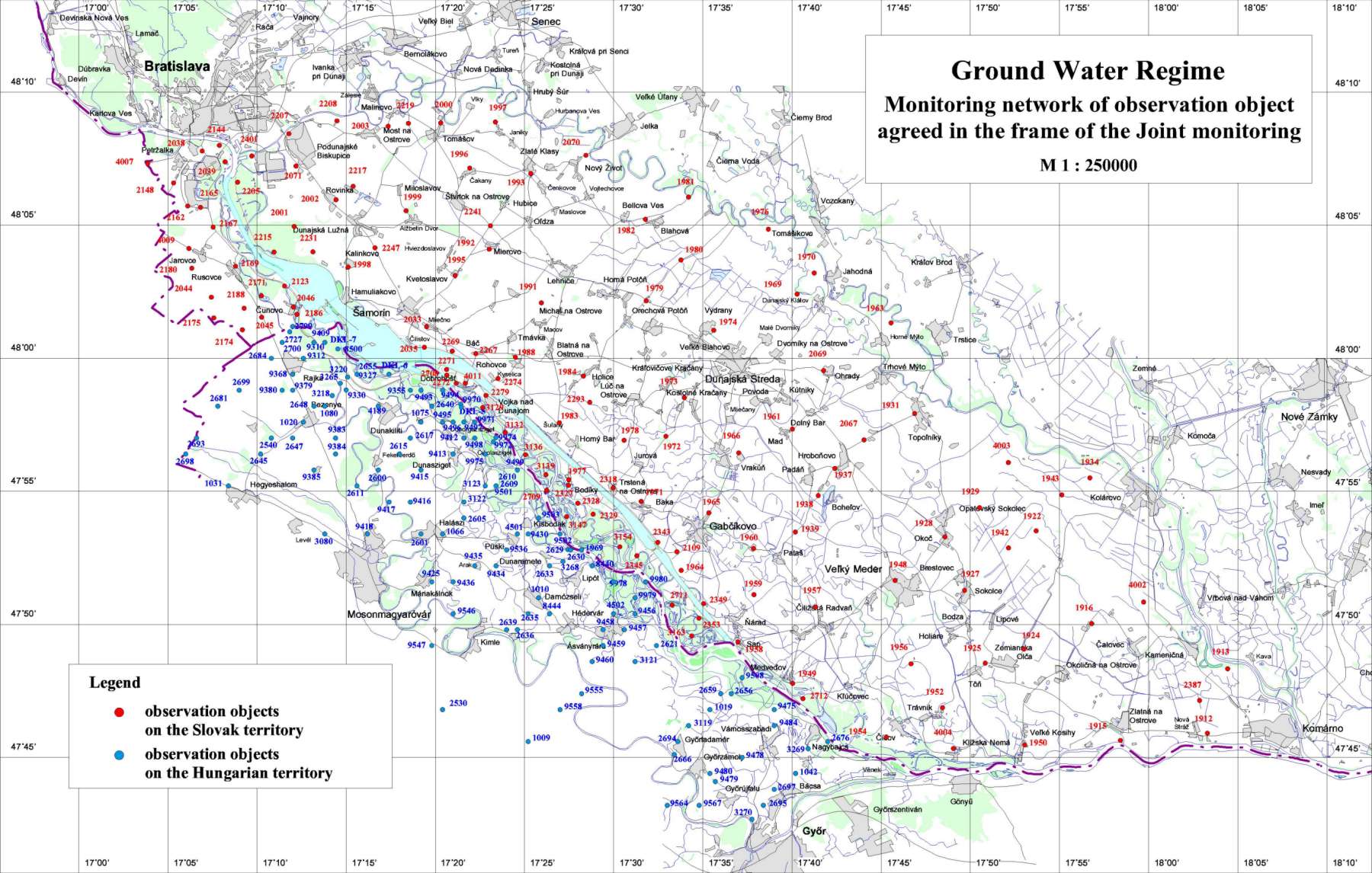
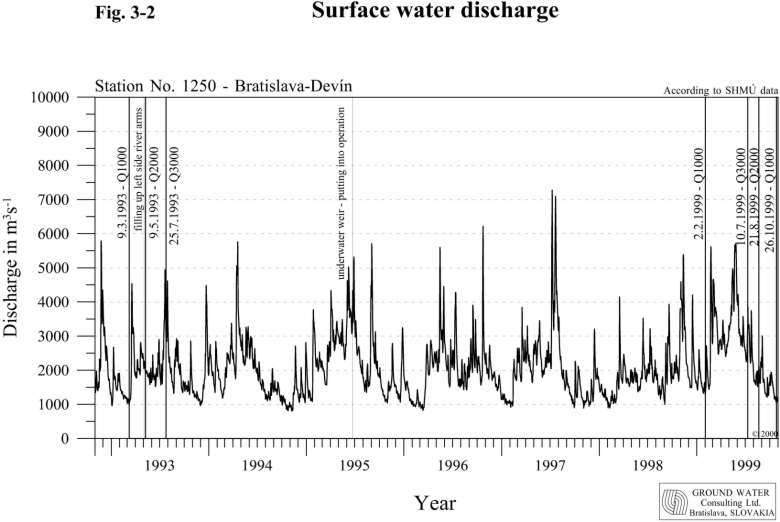
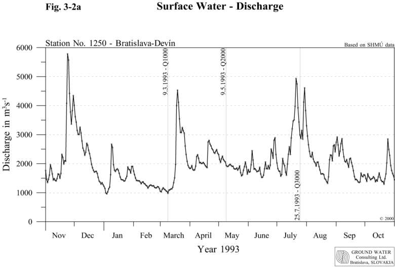
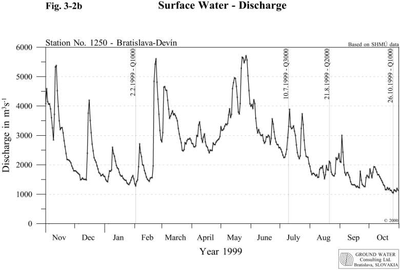
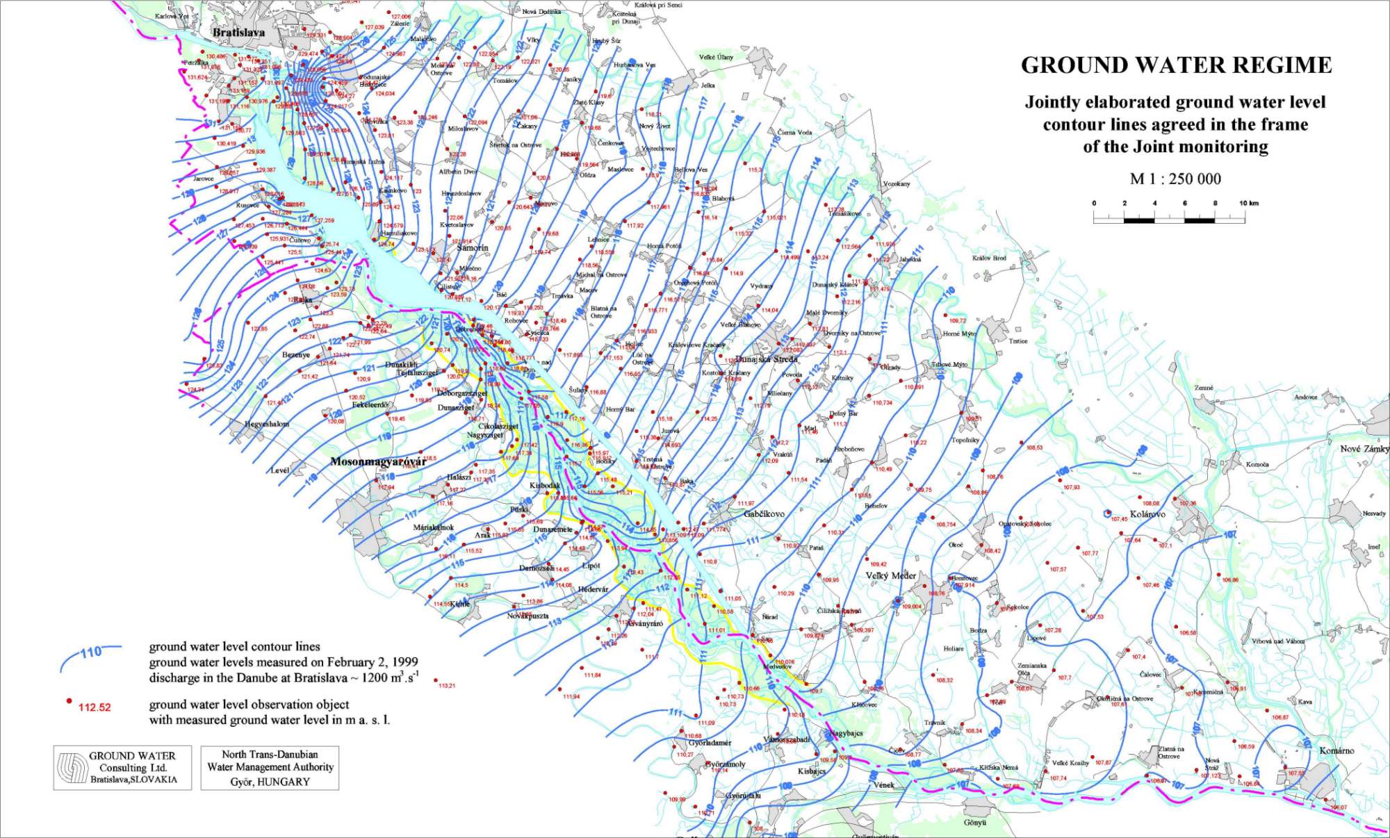
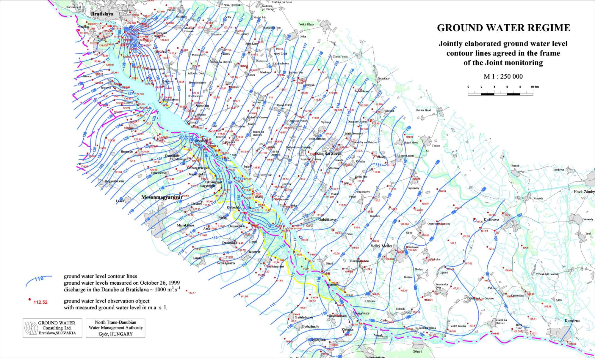
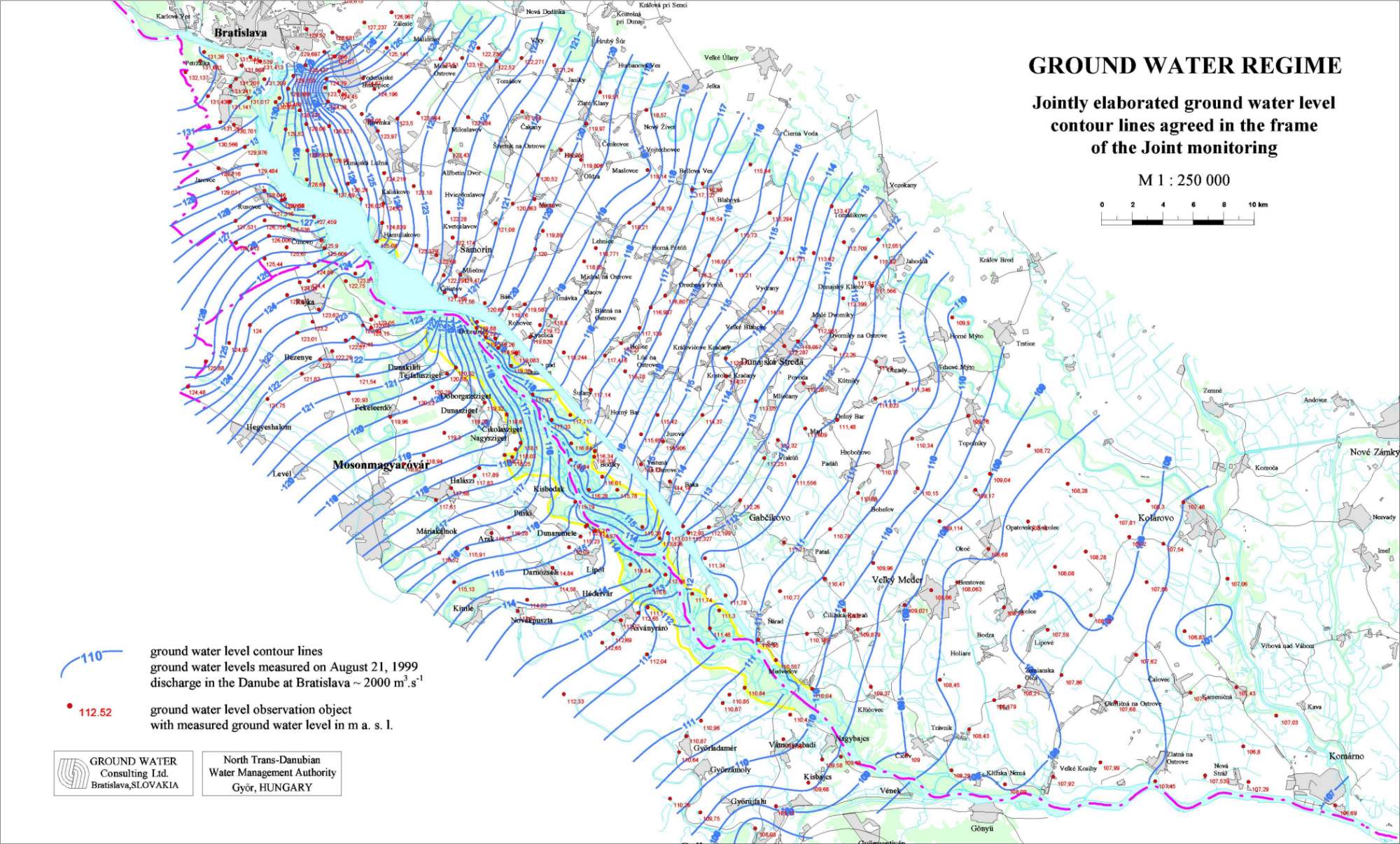
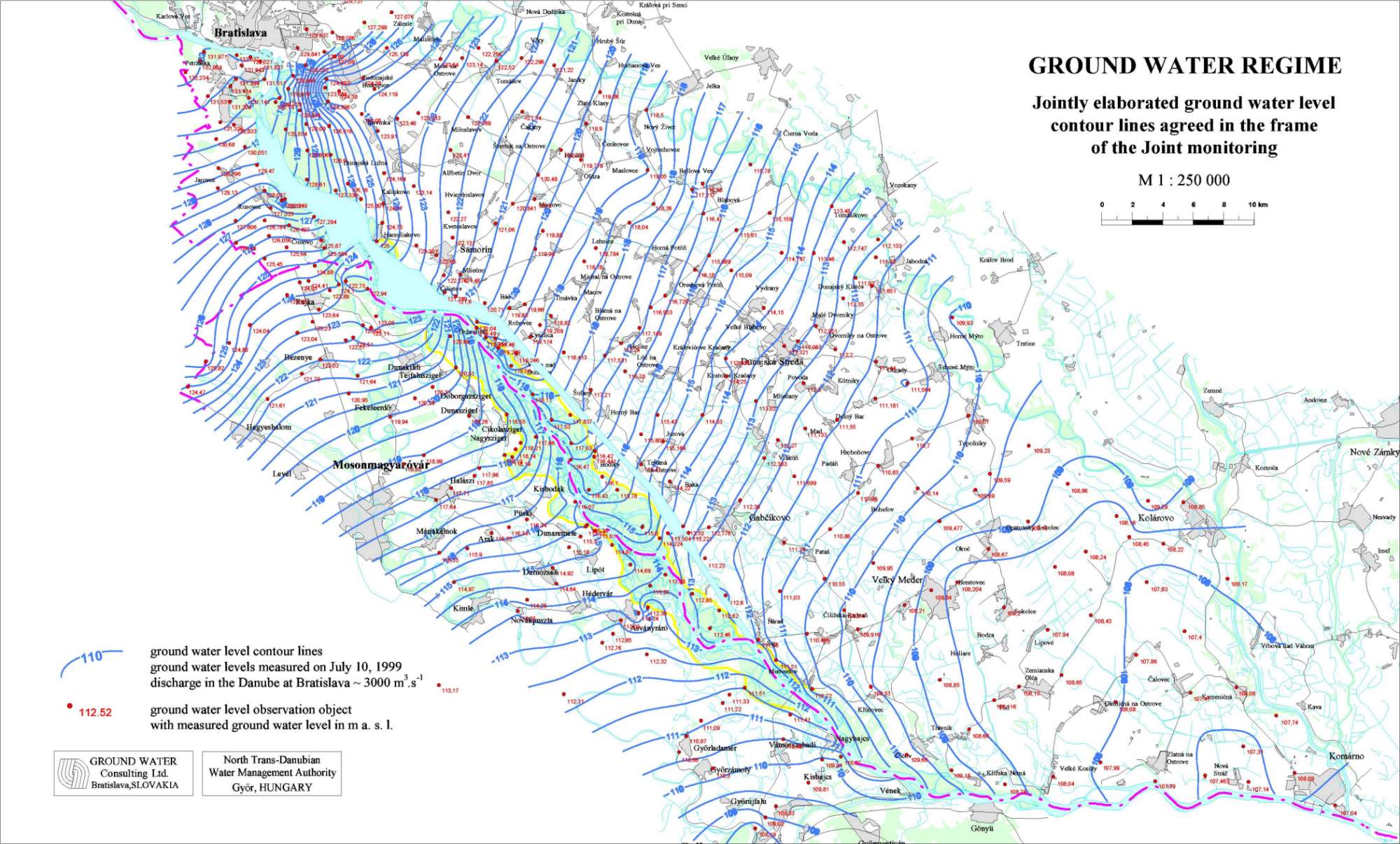
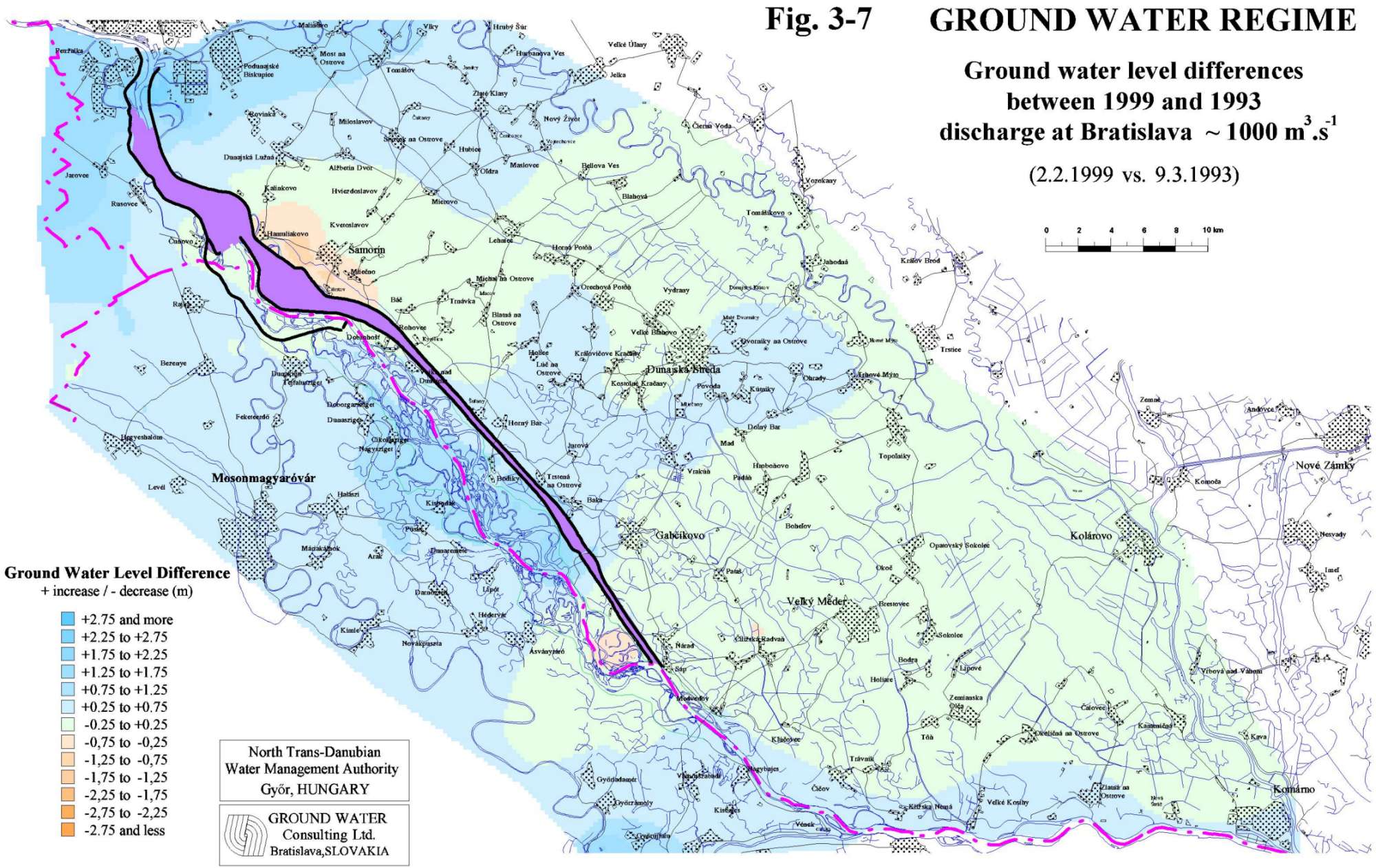
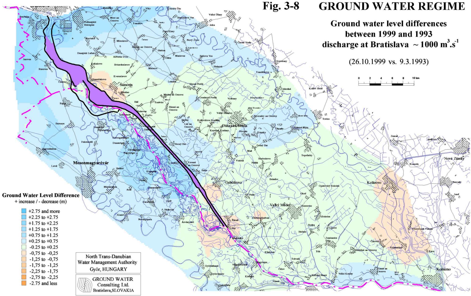
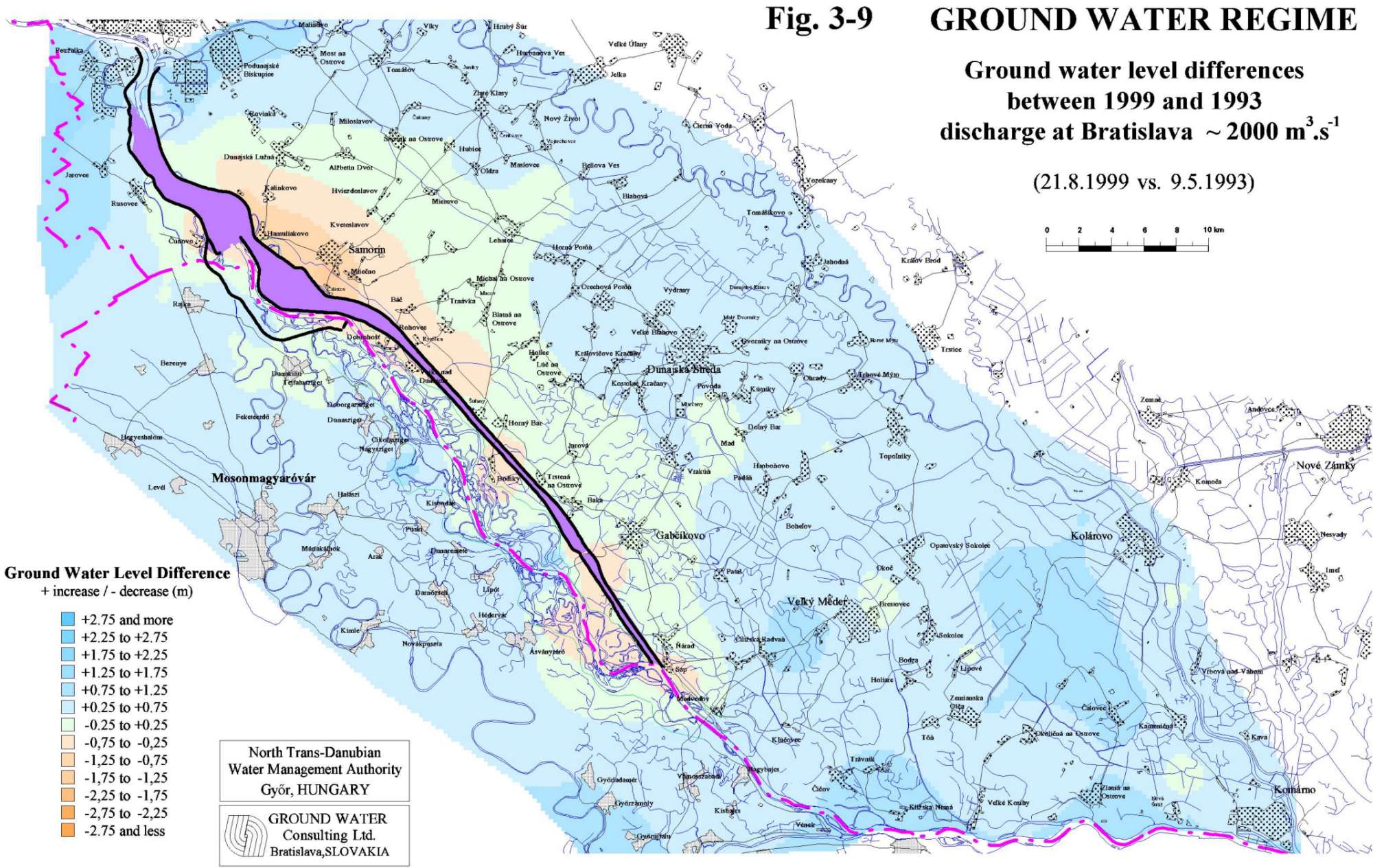
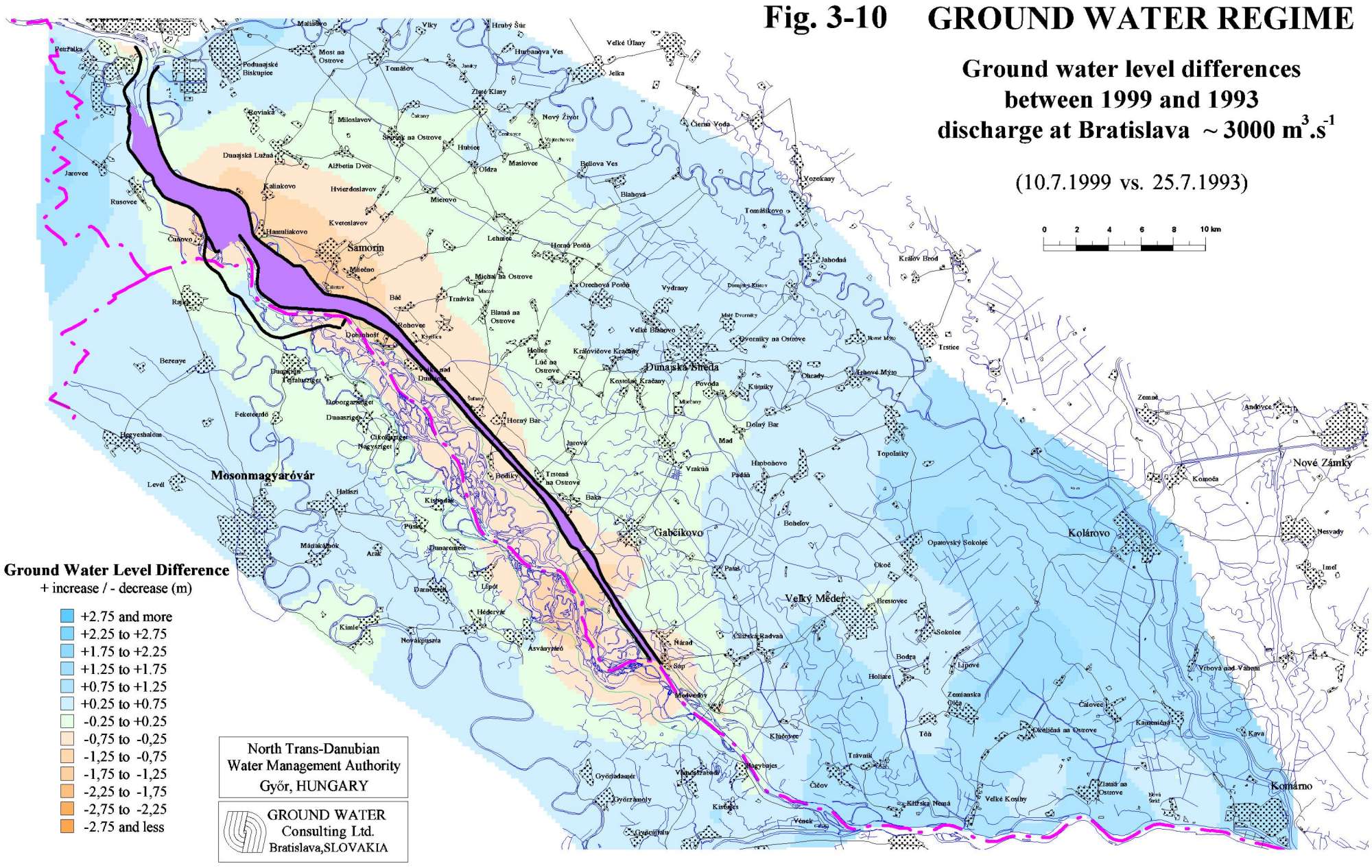
PART 3Ground Water RegimeThe impact of the temporary technical measures and discharges to the Danube and Mosoni branch of the Danube, realised according to the Agreement, and the impact of the water supply realised on the Hungarian side on the ground water regime and ground water levels is monitored by 253 observation wells situated in the area of Žitný ostrov and in the Szigetköz region. The network of observation objects on both sides is shown in Fig. 3-1. The evaluation of ground water level data was elaborated both in local and regional scale. The evaluation of local changes in 1999, elaborated by the Parties themselves, is given in the respective National Annual Reports. The jointly elaborated regional evaluation given in this report was prepared according to the jointly constructed equipotential lines. The equipotential lines were constructed for comparison of the ground water levels in the influenced area before and after the construction of submerged weir and introducing the water supply into the river branches on the Hungarian side. 3.1. Joint evaluation of the ground water regimeThe ground water level in the area influenced by the water supply depends mainly on the surface water level fluctuation. Comparable hydrological situations were chosen in the period before and after introducing the water supply for the ground water regime evaluation. Three different hydrologic situations were selected to characterise the low, average and high discharge conditions in the Danube, corresponding to discharges approximately 1000, 2000 and 3000 m3.s-1 . The selected dates and the corresponding discharges in the Danube at Bratislava-Devín gauging station are the following Tab. 3-1, Fig. 3-2a, Fig. 3-2b: Table 3-1
For low discharge conditions two different dates were chosen in 1999, because the discharge during the low water period at the end of winter and beginning of spring was higher by app. 200 m3.s-1 comparing to the corresponding time period in 1993. The second date with low discharge conditions was chosen at the end of October 1999, when the amount of discharges were approximately equal but the weather conditions differs from the conditions in spring 1993. Maps of equipotential lines were jointly constructed for the selected dates using the measured ground water levels (Figs. 3-3 to 3-6). In the wells where the water level is measured once a week the ground water level for the selected dates were computed by linear interpolation. The altitudes of the ground water levels are given for each observation object used for the equipotential line construction. For the equipotential lines construction the surface water level for each exact rkm in the Danube riverbed in the stretch between rkm 1850-1794 were used as well. These levels were computed by interpolation of all gauging station data on given stretch. The other surface water levels were not used for construction of the equipotential lines. The constructed equipotential lines represent general ground water levels and do not show the local influence of the channels or the river branch systems. The differences between the measured ground water levels for the selected comparable hydrological situations are given in Figs. 3-7 to 3-10. The evaluation is focused mainly to the area influenced by the technical measures and discharges according to the intergovernmental Agreement and by the water supply realised on the Hungarian side. The influenced area on the Hungarian side is in this sense represented by the inundation and the flood-protected area, on the Slovak side partly by the inundation area. Low discharge conditions Comparing the hydrological situations in the period before and after (both situation) realising the technical measures and discharges according to the Agreement (1999 versus 1993) it can be stated that as a consequence of increased water levels and water supply on the Hungarian side on a major part of influenced area, both on the flood-protected area and inundation area as well, at low discharge conditions in the Danube (approximately 1000 m3.s-1) increase of ground water level occurred (Fig. 3-7, Fig. 3-8). The ground water level in the area around and upstream the submerged weir is similar or slightly higher comparing the period before constructing the submerged weir. Increase of ground water level occurred along the Mosoni Danube in the upper and middle part of Szigetköz area. As a result of the water supply to the inundation area increase of ground water level by 1 m can be observed in the middle part of Szigetköz area. Slight decrease of ground water levels upstream of the confluence of the Danube old river bed and the tail-race canal is caused by decrease of surface water level in the Danube. The reason is the partial deepening of the tailrace canal and erosion of the Danube riverbed downstream of the confluence with a tailrace canal. The increase in the Slovak inundation area along the river branches is due to the fact, that there was no water supply into the river branch system in March 1993. The slight decrease of ground water levels around the lower part of the reservoir is due to different water level management in the left side seepage canal. Average discharge conditions Similarly to the low discharge conditions, the technical measures and the discharges according to the Agreement and the water supply on the Hungarian side at average discharge conditions in the Danube (approximately 2000 m3.s-1) evoked a slight increase of ground water level as well (Fig. 3-9). In the upper and middle part of the Szigetköz the water supply according to the Agreement evoked increase of ground water levels around 0.3-0.5 m. In the lowest part of the Szigetköz area (lowest part of the Ásványi river branch system and the Bagoméri river branch system) the ground water levels are slightly lower. On the Slovak territory no impact of the technical measures according to the Agreement appears. The decrease of ground water levels around the reservoir is probably caused by different manipulation on the seepage canal. Similarly to the conditions of low discharges a slight decrease of ground water levels upstream of the confluence of the Danube old river bed and the tail-race canal can be observed as well. This is caused by decrease of surface water level in the Danube. The reason is the partial deepening of the tailrace canal and erosion of the Danube riverbed downstream of the confluence with a tailrace canal. High discharge conditions At high discharge conditions in the Danube (approximately 3000 m3.s-1) some impact of the technical measures according to the Agreement occurs in the area upstream of the submerged weir (Fig. 3-10). The ground water level increase along the Mosoni Danube evoked by the water supply is less expressive and range up to 0.4-0.5 m. Along the Danube old river bed and in the lower part of the Szigetköz, in the area of confluence of the tailrace canal and Danube the decrease of ground water levels are significant, which is caused low water level comparing the high discharge conditions in the Danube. The decrease on the Slovak side, besides the surrounding of the reservoir, is expressed in the river branches and similarly in the area at the confluence of the tailrace canal and the Danube. At the end it can be concluded from these maps that the water supply enabled by the technical measures and discharges according to the Agreement has caused significant rise of ground water levels on Hungarian territory for average and low discharge conditions in the Danube. The extent of this influence can be seen on the difference map for low and average discharges between the years 1999 and 1993. The water supply according to the Agreement has not caused a significant change in the ground water levels for high discharge conditions. If it is desired to raise ground water level in the lowest part of the inundation area, which is not influenced by water supply according to the Agreement, additional measures are required.
|
|||||||||||||||||||||||||