Dean of the Faculty of Natural Sciences, Comenius University Bratislava
CONCLUSIONS This study discusses following topies: position of the georelief in the landscape and its influence on the spatial differetation of landscape-ecological processes, landscape as aspatially organized autoregulating system and the georelief as its spatial subsystem, expression of the set of its morphometric quantities characterising georelief in its arbitrary point, geometric forms the georelief on the basis of morphometric parameters, moddeling of georelief by Conplex Digital Model as integral part of GIS.
Landscape is a planet-wide, complex, spatially organized whole possessing its own self control mechanisms and its own circulation of mater, energy and information. The man (human society) interacts with the natural parl of the landscape and the human activity is thus embeldded in the landscape. One of the landscape. One of the most important factors affecting the spatial differentiation of processes in the landscape is the georelief.
Georelief is one of dominant components in landscape. It influences by its geometry upon not only spatial differentiation of ecological processes in lanscape but spatial differentation various kinds of human activities in space as well.
The relief of the Earth (georelief) with it geometric characters is from one side the resultant of processes running in landscape and from second side these processes are influenced and spatially differentiated by its own geometry.
Georelief is noticed in each scientific discipline in its point of view. This point of view is given by object and subject of study of relevant scientific discipline as well as by the aim of work and realisation result. So e.g. genetic forms of georelief, their development, dynamics considering to characters of geologic underlying rock and considering to all processes which model the surface of underlying rock, there is studied by geomorphology. These processes are a part of total processes in landscape. Geomorphometry studies the geometry of relief of the Earth which can by studied from many points of view however its own substance there is the geometry of georelief.
Georelief is interesting as firm but dynamic interface between atmosphere and hydrospere resp. on the one side and pedosphere with part of biosphere and lithosphere on the other side. This firm but dynamic interface is always considered in certain scale and on the certain discintive level. From theoretico-methodological point of view relief is interesting as dynamic surface characterized in each arbitrary point (exactly in differently small surface element dp) by the set of quantitative indicese and quantities resp.(morphometric parameter). Such morphometric quantities are interesting which express geometric characters of the relief including its geometric forms in relation to other landscape elements as spatially organised dynamic system with own specific circulation of subslantes, energy and information.
The geometry of this way considered surface is interesting which as a result of modelling processes there is from one side "a respond" of physical, chemical and other characters of geologic underlying rock (lithospheric upper layers) to these processes, from other side it influences upon spatial differentiation of all processes in landscape. However it is expressed simplier. An important fact wanted to be pointed out that one of the basic tasks of geomorphometry there is the observation of the Earth relief geometry as a part landscape and the formulation such morphometric quantities characterizing relief in each its arbitrary position which is characterized by structural geometric characters of relief relevant simultaneously even from point of view of landscape and processes running in it.
These morphometric quantities from one side:
- give information enclosed in relief geometry about its development
so they are "memory quantities",
- from the other side they are input variable quantities form exact
expression of georelief influence upon processes in landscape, upon their
spatial differentiation.
Firstly let landscape characterize from point of view of our requirements so that relief as a part of landscape can be appropriately expressed. In literature a landscape is characterised as substance - energetic spatially organized complex with own specific substances and energy circulation in which according the paper NEEF, E (1967) there exists interrelations and interconnections.
It can be briefly mentioned that the problems of landscape (in broad sense of word of physico-geographical sphere) as spatially organized complex with own specific substances and energy circulation which is spatialy differentiated into particular spatial landscape units have been worked out mainly in German and Russian (later Soviet) so called "landschaft school". From large amount of papers concerning this sphere, from our point of view papers can be mentioned as follows: ARMAND, D. L. (1975), CAROL, H-NEEF, E. (1957), BARSCH, H. (1971), BOBEK, H.- SCHMITHUSEN, J. (1949), DRDOŠ, J. (1973), GERASIMOV, I. P. (1983), HASSE, G. (1964), ISAČENKO, A. G. (1965,1981), LESER, H. (1974, 1976), NEEF, E. (1963,1967), SCHMITHUSEN, J. (1948,1968,1970), SOČAVA (1978).
In Anglo-Saxon literature these problems have been formulated and developed in ecology with biological accent. There is newer approach in broade inter-disciplinary context formulated and developed in so called environmentalism which has been gradually constituted as independent broaddrawn inter-disciplinary scientific division. This term in broad sense begins to extend and develop even in countries of German and Russian "landschaft schools". However, in environmentalism, the part which develops landscape ecology and understands landscape as patially organized complex is more orless identical with so called complex physical geography of German, Russian and Soviet "landschaft schools". On the whole nowadays understood environmentalism has broader inter-disciplinary range, even if it has big penetriation into mentioned "landschaft school". In German geographical literature of "landscaft school" even the term "geoecology" has been introduced.
The problem of landscape as spatially organized complex in scientific literature has been transmissed even from point of view of systems theory.
On various level of complexity from landscape point of view the theory of geosystems has been worked out ALEXANDROVA, T. D. - PREOBRAŽENSKO, V.S. (1978), ARMAND, A. D. (1966, 1972, 1973, 1975), AURAD, K. D. (1979, 1982, 1983), BENNET, R. J. - CHORLEY, R. J.(1978), DEMEK, J. (1974,1977), GOCHMAN, V. M.-MINC, A. A. - PREOBRAŽENSKIJ, V. S.(1971), CHORLEY, R J.-KENNEDY, B. A. (1971), JUDIN, E. G.(1978), KLUG, H.-LANG, R. (1983), LIPEC, J. G. (1980), SCHMIDT, G. (1974), ÚJVARI, I. (1979).
The landscape is conceived of as a spatially organized matter-energic
and information system SG(P,T), whose real geometric
space is delimited with respect to the reference surface of the Earth and
which is studied in the coordinate system <O, ![]() ,
,
![]() ,h>,
where O is the origin of the coordinate system being identical with
the centre of the reference surface of the Earth,
,h>,
where O is the origin of the coordinate system being identical with
the centre of the reference surface of the Earth, ![]() -
is the geographic latitude,
-
is the geographic latitude, ![]() -
is the geographic longitude and ±h is the altitude measured in the
direction of the normal to the reference surface, starting from the reference
surface of the Earth outside (+h) and inside (-h) (Fig.l).
-
is the geographic longitude and ±h is the altitude measured in the
direction of the normal to the reference surface, starting from the reference
surface of the Earth outside (+h) and inside (-h) (Fig.l).
We express therefore geographic sphere as spatially organized system SG(P,T) in a form of an ordered pair (couples)
SG(P,T) = (GG(P,T), RG(![]() P,T))
(1)
P,T))
(1)
where
GG(P,T) = [gi(P,T)]11i=1 (2)
is a set of spatially located elements gi(P,T), of
whieh this system consists, and RG(![]() P,T)
is a set of spatial relations rij(
P,T)
is a set of spatial relations rij(![]() P,T)
between bouth the elements gi(P,T)
P,T)
between bouth the elements gi(P,T) ![]() GG(P,T)and
the elements gi(P,T) and enviromnent (surroundning) go
of the system SG(P,T). (Fig l).
GG(P,T)and
the elements gi(P,T) and enviromnent (surroundning) go
of the system SG(P,T). (Fig l).
Under the environment (surroundnig) go we understand, according to works of KRCHO, J. (1968, 1974, 1981, 1983, 1990, 1991) the inside if the Earth E under Lower frontiere of the geographic sphere HD and high stratums of the athmosphere over the upper frontiere of the geographic sphere HD with a neighbouring cosmic space (Fig.l).
Set (2) can be, at the lowest resolution level, divided in two subsets
GAG(P,T) = [gf(P,T)]6f=1
![]() [ef(P,T)]6f=1
(3)
[ef(P,T)]6f=1
(3)
GFG(P,T) = [g6+k]5k=1
![]() [ak(P,T)]5k=1
(4)
[ak(P,T)]5k=1
(4)
In the subset subset GAG(P,T) is gf(P,T)
![]() ef(P,T)
for f=1,2,...,6
ef(P,T)
for f=1,2,...,6
and in the subset GFG(P,T) is gG+K(P,T)
![]() ak(P,T)
for k=1,2,...,5, where
ak(P,T)
for k=1,2,...,5, where
GG(P,T) = GAG(P,T) ![]() GFG(P,T)
; GAG(P,T)
GFG(P,T)
; GAG(P,T) ![]() GFG(P,T)
GFG(P,T)
![]() 0
0
Subset (3) is a subset of elements representing basic components of the socio-economic (human) sphere at the lowest resolution level i. e.
g1(P,T) ![]() e1(P,T) :
forestry sphere
e1(P,T) :
forestry sphere
g2(P,T) ![]() e2(P,T) :
agricultural sphere
e2(P,T) :
agricultural sphere
g3(P,T) ![]() e3(P,T) :
industrial sphere
e3(P,T) :
industrial sphere
g4(P,T) ![]() e4(P,T) :
transport and communication sphere
e4(P,T) :
transport and communication sphere
g5(P,T) ![]() e5(P,T) :
settlements sphere
e5(P,T) :
settlements sphere
g6(P,T) ![]() e6(P,T) :
biosphere (fito and zoosphere)
e6(P,T) :
biosphere (fito and zoosphere)
Subset (4) is a subset of elements representing basic components of the physico-geographic sphere at the lowest resolution level i. e.
g6+1(P,T) ![]() a1(P,T) :
athmosphere
a1(P,T) :
athmosphere
g6+2(P,T) ![]() a2(P,T) :
hydrosphere
a2(P,T) :
hydrosphere
g6+3(P,T) ![]() a3(P,T) :
lithosphere
a3(P,T) :
lithosphere
g6+4(P,T) ![]() a4(P,T) :
pedosphere
a4(P,T) :
pedosphere
g6+5(P,T) ![]() a5(P,T) :
biosphere
a5(P,T) :
biosphere
By the symbol P = ![]() ,
,
![]() , h
is expressed, in given coordinate system <O,
, h
is expressed, in given coordinate system <O, ![]() ,
,
![]() ,h>,
an absolute position of individual elements in a given space,by the symbol
,h>,
an absolute position of individual elements in a given space,by the symbol
![]() P(
P(
![]()
![]() ,
,
![]()
![]() ,
,
![]() h )
is expressed relative position of two elements always, i. e. ei(P,T),
ej(P,T), ai(P,T) , aj(P,T) , where
h )
is expressed relative position of two elements always, i. e. ei(P,T),
ej(P,T), ai(P,T) , aj(P,T) , where
![]()
![]() ij
=
ij
= ![]() j
-
j
- ![]() i;
i;
![]()
![]() ij
=
ij
= ![]() j
-
j
- ![]() i;
i;
![]() hij
= hj - hi .
hij
= hj - hi .
By the symbol T is expressed a time parameter.
By the set is expressed a structure of the system (1); according to the works KRCHO, J. (1968, 1974, 1076, 1981, 1990) it is possible to
.gif) (5)
(5)
The elements of this matrix are submatrices, where
ROA(![]() P,T)
: submatrix of relations between environment (surrounding) go
and elements of the set GAG(P,T) ; this submatrix
expresses the influence of the environment (surrounding) go on
socio-economic sphere,
P,T)
: submatrix of relations between environment (surrounding) go
and elements of the set GAG(P,T) ; this submatrix
expresses the influence of the environment (surrounding) go on
socio-economic sphere,
ROF(![]() P,T)
: submatrix of relations between environment (surrounding) go
and elements of the set GFG(P,T) ; this submatrix
expresses the influence of the environment (surrounding) go on
natural part of the landscape,
P,T)
: submatrix of relations between environment (surrounding) go
and elements of the set GFG(P,T) ; this submatrix
expresses the influence of the environment (surrounding) go on
natural part of the landscape,
RAO(![]() P,T)
: submatrix of relations between elements of the set GAG(P,T)
and environment (surrounding) go , this submatrix
expresses the influence of elements of socio - economic sphere on the environment
(surrounding) go ,
P,T)
: submatrix of relations between elements of the set GAG(P,T)
and environment (surrounding) go , this submatrix
expresses the influence of elements of socio - economic sphere on the environment
(surrounding) go ,
RFO (![]() P,T):
submatrix of ralations between the set GFG(P,T) and the
environment (surrounding) go, this submatrix expresses
the influence of the natural part of the landscape on the environment (surrounding)
go
P,T):
submatrix of ralations between the set GFG(P,T) and the
environment (surrounding) go, this submatrix expresses
the influence of the natural part of the landscape on the environment (surrounding)
go
(RAG) ![]() (
(![]() P,T):
submatrix of relations between elements of the subset GAG(P,T)
; this submatrix expresses the structure within the subsystem SAG(P,T)
which will be a subject of further interst,
P,T):
submatrix of relations between elements of the subset GAG(P,T)
; this submatrix expresses the structure within the subsystem SAG(P,T)
which will be a subject of further interst,
(RFG) ![]() (
(![]() P,T):
submatrix of relations between elements of the subset GFG(P,T)
; this submatrix expresses the structure within the subsystem SFG(P,T)
, which will be a subject of further interest,
P,T):
submatrix of relations between elements of the subset GFG(P,T)
; this submatrix expresses the structure within the subsystem SFG(P,T)
, which will be a subject of further interest,
RAF(![]() P,T)
: submatrix of relations between elements of GAG(P,T)
and elements of GFG(P,T) ; this submatrix expresses
the influence of elements of socio-economic sphere on elements of natural
part of the landscape,
P,T)
: submatrix of relations between elements of GAG(P,T)
and elements of GFG(P,T) ; this submatrix expresses
the influence of elements of socio-economic sphere on elements of natural
part of the landscape,
RAF(![]() P,T)
: submatrix of ralations between elements of GFG(P,T)
and elements of GAG(P,T) ; this submatrix expresses
the influence of natural part of the landscape on elements of socio-economic
sphere.
P,T)
: submatrix of ralations between elements of GFG(P,T)
and elements of GAG(P,T) ; this submatrix expresses
the influence of natural part of the landscape on elements of socio-economic
sphere.
All this can be ec onomically expressed in the form of an oriented graph (Fig 2).
In the system SG(P,T) (l) it is possible, according to the works KRCHO, J. (l968, 1974, 1981, 1990, 1991) to express two spatialy organized autonomous subsystem i.e.
SAG(P,T) = (GAG(P,T), RAG(![]() P,T)) (6)
P,T)) (6)
SFG(P,T) = (GFG(P,T), RFG(![]() P,T)) (7)
P,T)) (7)
which are in a interaction. Subsystem SAG(P,T) (6)
is a subsystem of the socio-economic sphere, subsystem SFG(P,T)
(7) is a subsystem of the physico-geographic sphere, GAG(P,T),
GFG(P,T) are elements (3), (4), RAG(![]() P,T)
is z matrix of the structure of the subsystem SAG(P,T)
; RFG(
P,T)
is z matrix of the structure of the subsystem SAG(P,T)
; RFG(![]() P,T)
is a matrix of the structure of the subsystem SFG(P,T).
P,T)
is a matrix of the structure of the subsystem SFG(P,T).
Subsystem SFG(P,T) (7) - physico-geographic sphere is a spatially organized and spatially complex with a specifie cireulation of matter, energy and information and with a specifie selfregulation mechanism.
Subsystem SAG(P,T) (6) - Human-geographic (socio-economic) sphere is also spatially differentiated and spatially highly organized complex with a specific selfregulation mechanism. Looking at the problem spatially, socio-economic sphere occur in a geometric space of physico-geographic sphere (in natural part of landscape).
Interaction of socio-economic and physico-geographic sphere produces spatially organized cultural landscape. Man's activity can produce spatially distributed disturbances in the natural landscape; it can also disturb selfregulation processe. Physico-geographic sphere attemps to compensate disturbances produced by man's activity.
Analysing the georelief we are interested in the following subsystem SFG(P,T)(7), which can also be studied as an autonomous, planet-wide and spatially organised system.
The natural part of the landscape, considered as a subsystem (7) is a spatially organized whole consisting of basic, spatially differentiated components:
a1(P,T), a2(P,T), a3(P,T), a4(P,T), a5(P,T),
all being in interaction.
The natural part of the landscape (7) is, with respect to the reference
surface of the Earth, spatialy delimited by the region of mutual spatial
intersection and by the interaction of individual spheres ak(P,T)(k
= 1,2,...,5).Vetical delimination of the system SFG(P,T)
(7) is given in the direction of normals to the reference surface of
the Earth, i.e.by HH ![]() hmax
from above nad by HD
hmax
from above nad by HD ![]() hmin
from below (Fig.l).
hmin
from below (Fig.l).
Interaction of individual spheres ak(P,T) ![]() GFG(P,T)
as elements of the system SFG(P,T) (7) produces processes,
specifiec only for the region of intersection, which are characterized
by the circulation of matter, energy and information.
GFG(P,T)
as elements of the system SFG(P,T) (7) produces processes,
specifiec only for the region of intersection, which are characterized
by the circulation of matter, energy and information.
To be able to express spatial differentiation of subsystems SAG(P,T) , SFG(P,T) (6), (7) we raise the resolution level in such a way that each of the elements ef(P,T), ak(P,T) of the sets GAG(P,T) , GFG(P,T) (3), (4) becomes an ordered subset of distinguished elements.
Gef = [efi]mfi=1 Gak = [akj]nkj=1 (8)
for each f = 1,2,...,6 for each k = 1,2,...,5
The elements
efi(P,T) ![]() Gef
(P,T)
Gef
(P,T)
represented for individual f = l, 2, 3, 4, 5, 6 components of individual original, however now interally distinguished components of socio-economic sphere, and elements
akj (P,T) ![]() Gak(P,T)
Gak(P,T)
represent form individual k = l, 2, 3, 4, 5 components of individual, however, now internally distinguished components (geospheres) of physico-geographical sphere.
The change (elevation) of the resolution level can lead to the situation under which the individual spheres ak (P,T) of GFG(P,T) are considered as ordered sets
ak (P,T) = Gak(P,T) = [akj]nkj=1 for each k = 1, 2, ..., 5
where individual elements akj present for k =
l, 2, 3, 4, 5, and j = l, 2, ...,nk, ( n1
![]() n2
n2
![]() ...
...
![]() n5)
individual components of the geosphere ak (P,T). Then
the set GFG(P,T) can be expressed as follows:
n5)
individual components of the geosphere ak (P,T). Then
the set GFG(P,T) can be expressed as follows:
.gif) (9)
(9)
Since between elements
akj (P,T) ![]() Gak(P,T)
Gak(P,T)
for each individual k = 1, 2, ..., 5, a set of relation can be observed, it is possible the individual spheres ak(P,T) to be analysed as spatially organized subsystems
Sak(P,T) = (Gak(P,T), Rak(![]() P,T)) (10)
P,T)) (10)
of the system SFG(P,T). The structure of the system
SFG(P,T) is then given by the set of distinguishable
relations RFG(![]() P,T)
between interacting subsystems (10).
P,T)
between interacting subsystems (10).
The system SFG(P,T) is in each position P = ![]() ,
,
![]() , h
of the delimited space and each T in some whereby the general
state of each element akj (P,T) , general state ZFG(P,T)
, which is characterized by general state Zak(P,T) of
the subsystems Sak(P,T)(10) and their elements akj
(P,T) , whereby the general state of each element akj
(P,T) , general states Zak(P,T) and hence also
the general state ZFG(P,T), are determined by state variables
z1, z2, ...,zn. These
variable can presemnt physical, physio-chemical, chemical, mathematical
and mathematico-statical quantities. States of each subsystem Sak(P,T)
of system SFG(P,T) and processes in lanscape which
are originated from mutual interaction of subsystems Sak(P,T)
expressed by the set RFG(
, h
of the delimited space and each T in some whereby the general
state of each element akj (P,T) , general state ZFG(P,T)
, which is characterized by general state Zak(P,T) of
the subsystems Sak(P,T)(10) and their elements akj
(P,T) , whereby the general state of each element akj
(P,T) , general states Zak(P,T) and hence also
the general state ZFG(P,T), are determined by state variables
z1, z2, ...,zn. These
variable can presemnt physical, physio-chemical, chemical, mathematical
and mathematico-statical quantities. States of each subsystem Sak(P,T)
of system SFG(P,T) and processes in lanscape which
are originated from mutual interaction of subsystems Sak(P,T)
expressed by the set RFG(![]() P,T)
can be expressed by state quantities Z1, Z2,
..., Zn. The course of prosesses in landscape in each
time moment T and in each position P = (
P,T)
can be expressed by state quantities Z1, Z2,
..., Zn. The course of prosesses in landscape in each
time moment T and in each position P = (![]() ,
,
![]() , h)
is characterized by these state quantities. The size of particular
state quantities Zi (i = 1, 2, ..., n) is changed
either in course of time T or in dependance on position P =
(
, h)
is characterized by these state quantities. The size of particular
state quantities Zi (i = 1, 2, ..., n) is changed
either in course of time T or in dependance on position P =
(![]() ,
, ![]() ,
h). There are values of particular state quantities Zi for
particular i = l, 2,..., n within certain intervals
,
h). There are values of particular state quantities Zi for
particular i = l, 2,..., n within certain intervals
[ZD(P,T)]i ![]() Zi(P,T)
Zi(P,T)
![]() [ZH(P,T)]i (11)
[ZH(P,T)]i (11)
where [ZD(P,T)]i is Lower value
of i-order state quantity which it reaches in position P = (![]() ,
,
![]() , h)
and [ZH(P,T)]i is upper value. Presented
record (11) expresses that the value [ZD(P,T)]i
, [ZH(P,T)]i for each one
i = l, 2, ...., n depends either on position P = (
, h)
and [ZH(P,T)]i is upper value. Presented
record (11) expresses that the value [ZD(P,T)]i
, [ZH(P,T)]i for each one
i = l, 2, ...., n depends either on position P = (![]() ,
,
![]() , h)
or the time T .
, h)
or the time T .
The state variables Z1, Z2, ...,
Zn are functionally interrelated and their values are
functions of the position P = (![]() ,
,
![]() , h)
and the time T . On this basis it is possible the system SFG(P,T)
(7) to be expressed by the equation system
, h)
and the time T . On this basis it is possible the system SFG(P,T)
(7) to be expressed by the equation system
Z1 = ![]() 1(Z2,
Z3, ...Zn) Z1=
Gi (
1(Z2,
Z3, ...Zn) Z1=
Gi ( ![]() ,
,![]() ,
h, T)
,
h, T)
Z2 = ![]() 2(Z1,
Z3, ...Zn) i =
l, 2, ...., n
2(Z1,
Z3, ...Zn) i =
l, 2, ...., n
Zn = ![]() n(Z1,
Z2, ...Zn) (12)
n(Z1,
Z2, ...Zn) (12)
The system SFG(P,T) is spatially differentiated into individual spatial subsystems SFG,n (P,T), (n = 1, 2, ...) which in the landscape present individual landscape spatial units - the geosystems (Fig.3). In this spatial differentiation the important role has the georelief which presents a firm, but dynamical interface of the surface parts of the lithosphere Sa3(P,T) and the pedosphere Sa4(P,T) with the atmosphere Sa1(P,T) and the hydrophere Sa2(P,T).
The spatial differentiation, or course of the surface parts the lithosphere as a subsystem Sa3(P,T) including pedosphere Sa4(P,T) is a result of the interaction of all susbystems Sak(P,T) in the system SaFG(P,T)during the time T .
Let us present a brief definition of the georelief as a subsystem SaRF(P,T)in the system SaFG(P,T).
Georelief is, at some resolution level, a firm, but dynamical interface
between lithosphere Sa3(P,T) or pedosphere Sa4(P,T)
with biosphere Sa5(P,T) on the one side (hand) and
the atmosphere Sa1(P,T) or hydrosphere Sa2(P,T)
on the other side (hand). This firm, but dynamical interface, when
analysed its spatial course in the coordinate system <O,![]() ,
,
![]() , h>
has attributes of the surface, created by the set of points on the normals
N to the reference surface within the interval (HH,
HD).
, h>
has attributes of the surface, created by the set of points on the normals
N to the reference surface within the interval (HH,
HD).
A complete definition of the georelief was given in the papers of KRCHO,
J. (1973, 1987, 1989, 1990); there also aditional remarks can be found,
which specify the land relief, the relief of the sea bottom, bottom of
lakes and the glacial relief. It is clear, already from the brief definition
of the georelief, that the value of the altitude h is in each point
Ai(![]() i,
i,
![]() i,
hir) of the georelief and or each time point T an
output of the preceding gradual change of the general states Zak(P,T)
of the subsystems Sak(P,T) ( k = 1,2,3,4,5)
determined by state variables Z1, Z2,
..., Zn . The spatial distribution of altitudes hir
of points Ai(
i,
hir) of the georelief and or each time point T an
output of the preceding gradual change of the general states Zak(P,T)
of the subsystems Sak(P,T) ( k = 1,2,3,4,5)
determined by state variables Z1, Z2,
..., Zn . The spatial distribution of altitudes hir
of points Ai(![]() i,
i,
![]() i,
hir) creating the georelief, is thus in functional relation
to state variables Zn (n = 1,2, ...) whereby the
values of the individual state variables both interrelate and functions
of the position
i,
hir) creating the georelief, is thus in functional relation
to state variables Zn (n = 1,2, ...) whereby the
values of the individual state variables both interrelate and functions
of the position ![]() ,
,
![]() , h
and the time T ; hence, they are determined by the equation
system (12). The value of the altitude k as a function of state
variables Z1, Z2, ..., Zn ,
position
, h
and the time T ; hence, they are determined by the equation
system (12). The value of the altitude k as a function of state
variables Z1, Z2, ..., Zn ,
position ![]() ,
,
![]() , h
and time T can be expressed in the following general form:
, h
and time T can be expressed in the following general form:
h = fRF (Z2, Z3,
...Zn)
Z1 = ![]() 1(Z2,
Z3, ...Zn) Z1=
gi (
1(Z2,
Z3, ...Zn) Z1=
gi ( ![]() ,
,![]() ,
h, T)
,
h, T)
Z2 = ![]() 2(Z1,
Z3, ...Zn)
2(Z1,
Z3, ...Zn)
Zn = ![]() n(Z1,
Z2, ...Zn) (13)
n(Z1,
Z2, ...Zn) (13)
Equation system (13) puts down the spatial distribution of altitudes of georelief and its development in the time T with respect to the modelling processes. Equation system (13) enables to express an ordered set of morphometrical parameters
GRF(P,T) = [ ![]() h(
h(![]() P,T),
P,T),
![]() N(P,T),
AN(P,T),
N(P,T),
AN(P,T), ![]() (P,T),
(KN)t(P,T), Kr(P,T), ...] (14)
(P,T),
(KN)t(P,T), Kr(P,T), ...] (14)
as dependent variables upon state variables Z1, Z2,
..., Zn, position ![]() ,
,
![]() , h
and the time T , where
, h
and the time T , where
![]() h(
h(![]() P,T)
denotes the relative height in the direction of orthogonal lines,
P,T)
denotes the relative height in the direction of orthogonal lines,
![]() N(P,T)
the slope (inclination) of the georelief in the direction of orthogonal
lines,
N(P,T)
the slope (inclination) of the georelief in the direction of orthogonal
lines,
AN(P,T) the orientation (exposition) of the georelief
with respect to the cardinal points,
![]() (P,T)
the normal curvature of the georelief in the direction of orthogonal
lines (not identical with extreme normal curvature of Dupen indikatrix),
(P,T)
the normal curvature of the georelief in the direction of orthogonal
lines (not identical with extreme normal curvature of Dupen indikatrix),
(KN)t(P,T) the normal curvature of the
georelief in the direction of tangent to the contour line,
Kr(P,T) the horizontal curvature of the georelief
(curvature in the direction of contour lines), etc. Each individual morphometrical
parameter from the set (14) is determined by the functional relationship
derived from equation system (13).
Georelief in the spirit of the preceding definition, as a dynamic surface, can thus be considered as a specific, dynamic, spatially, organized, inmaterial subsystem
SRF (P,T) = [GRF (P,T), RRF (P,T)] (15)
being determined both by the equation system (13) and by the set of functions associated with the set of morphometric parameters GRF (P,T) (14), derived from the equation system (13).
Georelief is, on the one hand, an output of processes resulting from
interaction of the subsystems Sak (P,T), on the other
hand, however, it alone affects these subsystems. Its altitude h and
hence its individual elements in the ordered set GRF (P,T)
(14) change in each point Ai(![]() i,
i,
![]() i,
hir) in the time T in dependence upon state variables
and upon the dynamics of the general state of subsystems Sak (P,T)
of the system SFG (P,T).
i,
hir) in the time T in dependence upon state variables
and upon the dynamics of the general state of subsystems Sak (P,T)
of the system SFG (P,T).
Morphometric quantities (14) are dynamic quantities which are changed in course of time T due to modelling processes. Starting point form their derivation on dynamic terrain surface there are first and second differentials dh, d2h on the function
h = fRF (Z2, Z3, ...Zn)
in equation system (13), where
.gif) (16)
(16)
whereby dZi( i = 1,2, n) on the basic of relations (13) are expressed by relations
.gif) (17)
(17)
for i = 1,2,..., n i.e. for i = 1
j = 2,3,...,n
for i = 2 j
= 1,3,...,n
- -
- -
for i = n j =
1,2,...,n -1
Because state quantities Z1, Z2,
..., Zn are simultaneously the functions of position
![]() ,
, ![]() ,
h and time T , for their differential due to
,
h and time T , for their differential due to
Z1= gi ( ![]() ,
,![]() ,
h, T)
,
h, T)
for particular i = 1,2,...,n there is valid
.gif) (18)
(18)
Therefore the differentials dZi in relations (17) can be expressed due to (13) in the form
dZi = Didh + Mid![]() +
Nid
+
Nid![]() +
LidT (19)
+
LidT (19)
who
.gif) (19')
(19')
In this way there are the differentials dZi( i
= 1,2, n) in relation (16) of particular variable quantities
Zi expressed due to the position ![]() ,
,
![]() , h
and due to the time T .
, h
and due to the time T .
On the basis (19) the relation (16) for differential dh after modification can be expressed in the form
.gif) (20)
(20)
In this relation (20) from point of view of its following simplification
particular components are signed according ![]() ,
,
![]() , h,T
by symbols
, h,T
by symbols
.gif) (21)
(21)
then relation for first diffrential dh (20) can be expressed in the form
![]() (22)
(22)
Second differential d2h is expressed on basis of relation (20) so
.gif) (23)
(23)
If relation (22) is modificated due to dh into the form
![]() (24)
(24)
and info the form
![]() (24')
(24')
The differential equation of dynamic terrain surface which geometry
is resultant of state quantities Z1, Z2,
..., Zn as functions of position P = ( ![]() ,
,
![]() , h)
and their changes in time T will acquired in common form . For
determined value T = const. there is (22), (23), (24) and (24')
the component Ft= 0, so in this case the equations (24)
and (24') express the state of georelief as a result of modelling processes
in determined time T . The realtions (22),(23) for T = const.
will aquire the form
, h)
and their changes in time T will acquired in common form . For
determined value T = const. there is (22), (23), (24) and (24')
the component Ft= 0, so in this case the equations (24)
and (24') express the state of georelief as a result of modelling processes
in determined time T . The realtions (22),(23) for T = const.
will aquire the form
![]() (25)
(25)
![]() (25')
(25')
The relations (22),(23) form T = const and h = const. will aquire the form
![]() (26)
(26)
![]() (26')
(26')
The equations (24), (24') resp. are rather complicated therefore from
point of view on the aim of paper they have only theoretico-methodological
meaning, mainly their initial form (22). It is only starting point for
derivation of morphometric quantities ![]() N(P,T),
AN(P,T) in the set (14). On the basis (22) relation for
vector gradient grad h wich |grad h| = tg
N(P,T),
AN(P,T) in the set (14). On the basis (22) relation for
vector gradient grad h wich |grad h| = tg![]() N
and from which can be acquired that
N
and from which can be acquired that
![]() N
= arctg(|grad h|) (27)
N
= arctg(|grad h|) (27)
whereby ![]() N(P,T)
is be the component of the set (14). Vector grad h forms gradient
field on referential surface of the Earth whereby gradient grad h is
oriented to the side dh/dn > 0 in direction of orthogonal
trajectories to the isolines field of altitudes h , i.e. to the
contour lines field on referential surface. Referential surface of the
Earth (referential global surface or surface of referential ellipsoid)
is simultaneously scalar basis either vector field h or the other
fields, so called structural fields of georelief formed by componenets
of the set (14).
N(P,T)
is be the component of the set (14). Vector grad h forms gradient
field on referential surface of the Earth whereby gradient grad h is
oriented to the side dh/dn > 0 in direction of orthogonal
trajectories to the isolines field of altitudes h , i.e. to the
contour lines field on referential surface. Referential surface of the
Earth (referential global surface or surface of referential ellipsoid)
is simultaneously scalar basis either vector field h or the other
fields, so called structural fields of georelief formed by componenets
of the set (14).
The relation for grad h for T = const. from the relation (25) in this way that the derivation dh/dn direction of tangents to orthogonal trajectories of isolines field of altitudes (to the contour lines field) i. e. in direction of normal n to contour lines on referential surface of the Earth which has the form after arrangement is expressed
![]() (27')
(27')
and which is adjusted in coordinates system <O, ![]() ,
,
![]() , h>
, into the form of scalar product of two vector .
, h>
, into the form of scalar product of two vector .
.gif) (28)
(28)
In relation (28) the vector grad h is expressed by the relation
.gif) (29)
(29)
and its unitary vector n0 is expressed by the relation
![]() (30)
(30)
The vectors u, v are considered as unitary vectors oriented in
direction of parallels ![]() and
in direction of meridians
and
in direction of meridians ![]() .
From the relation (29) is resulted that
.
From the relation (29) is resulted that
.gif) (31)
(31)
For direction of vector grad h determined by angle which is simultaneously
in coordinates system <O, ![]() ,
,
![]() , h>
the angle of relief orientation to cardinal points, the relation is
aquired
, h>
the angle of relief orientation to cardinal points, the relation is
aquired
.gif) (32)
(32)
In following procedure, due to simplification of problem, which does
not influence upon the correctness of procedure and correctness of solution
there will be supposed that state quantities Zi (i
= 1, 2, ..., n) are only the functions of posotion ![]() ,
,
![]() (i.e.
h = const., T = const.). So in the relations (17), (18) for
particular i = 1, 2, ..., n will be Di
= 0 and Li = 0, so the relations (22), (23) will have
the form (26) (26').
(i.e.
h = const., T = const.). So in the relations (17), (18) for
particular i = 1, 2, ..., n will be Di
= 0 and Li = 0, so the relations (22), (23) will have
the form (26) (26').
The dynamics of the change of h-values, as well individual morphometric
parameters in GRF(P,T) (14) is but in lanrger spatial
dimension much slower than the dynamics of the subsystems Sa1(P,T),
Sa2(P,T); it depends upon the attributes of the subsystem
Sa3(P,T) . From point of view of the morphometric analysis
of georelief as subsystem of landscape for different time interval (![]() TPK)i
<Tp, Tk>i (
TPK)i
<Tp, Tk>i (![]() TPK)i
= 5, 10, 20, 30, 50, 100, ... years which depends on the scale
of map 1: Mi( i = 1,2,...) and its discintive
level where M1 = 1 000, M2 = 2 000,
M3 = 5 000, M4 = 10 000, M5
= 25 000, M6 = 50 000 the parameter of time
can be eliminated T = const. and only the influence of relief geometry
upon ecological proceses in landscape can be studied however not on the
contrary. Modelling the influence of the georelief on the spatial differentiation
of proceses in the landscape makes it thas possible the time parameter
T , considered in the form of shorter time intervals (
TPK)i
= 5, 10, 20, 30, 50, 100, ... years which depends on the scale
of map 1: Mi( i = 1,2,...) and its discintive
level where M1 = 1 000, M2 = 2 000,
M3 = 5 000, M4 = 10 000, M5
= 25 000, M6 = 50 000 the parameter of time
can be eliminated T = const. and only the influence of relief geometry
upon ecological proceses in landscape can be studied however not on the
contrary. Modelling the influence of the georelief on the spatial differentiation
of proceses in the landscape makes it thas possible the time parameter
T , considered in the form of shorter time intervals (![]() TPK)i=
5,10,20,... years, to be taken in equation system (13) as a constant, viz.
starting with some time point Tpand finishing with the
time point Tk , i. e. the interval (
TPK)i=
5,10,20,... years, to be taken in equation system (13) as a constant, viz.
starting with some time point Tpand finishing with the
time point Tk , i. e. the interval (![]() TPK)i
<Tp, Tk> ((
TPK)i
<Tp, Tk> ((![]() TPK)i
= (Tp)i - (Tk)i
i = 1, 2, ... )The length of interval (
TPK)i
= (Tp)i - (Tk)i
i = 1, 2, ... )The length of interval (![]() TPK)idepends
upon the scale of the map its resolution level.
TPK)idepends
upon the scale of the map its resolution level.
In the influence of relief upon ecological processes in landscape is
only studied then the chandge of relief for given time interval (![]() TPK)i
in selected scale 1: Mi will be considered
as null i. e. relief will be considered as constant and so static system.
There is the substance of this consideration that the change od relief
for selected scale 1: Mi in the length of its relevant
time
TPK)i
in selected scale 1: Mi will be considered
as null i. e. relief will be considered as constant and so static system.
There is the substance of this consideration that the change od relief
for selected scale 1: Mi in the length of its relevant
time ![]() Ti
is below its distinctive level therefore during this interval
it does not manifest. Moreover its morphometric quantities (morphometric
parameters) as input variables their physical meaning is simultaneously
saved. Relief influences by them upon processes and their spatial differentiation
in landscape whereby in selected scale 1: Mi during time
(
Ti
is below its distinctive level therefore during this interval
it does not manifest. Moreover its morphometric quantities (morphometric
parameters) as input variables their physical meaning is simultaneously
saved. Relief influences by them upon processes and their spatial differentiation
in landscape whereby in selected scale 1: Mi during time
(![]() TPK)i
is considered as non-variable (constant). It means that during
this time the influence of processes upon relief is not considered.
TPK)i
is considered as non-variable (constant). It means that during
this time the influence of processes upon relief is not considered.
In this case (for T = const.) even in the relation (22) (23) there will be FT = 0, so they will have the form (26),(26´). From (26) on the reference global surface (on reference surface of the Earth) for vector grad h and its unitary vector n0 the relation is acquired
.gif) (33)
(33)
There is resulted from the relation (33) that absolute value of vector grad h i. e.
.gif) (33´)
(33´)
The spatial distribution of the altitudes h is in this case dependent
only on the position ![]() ,
,
![]() , i.
e. the altitudes are now only the function of the position
, i.
e. the altitudes are now only the function of the position ![]() ,
,
![]() . Thaking
into account this theoretico-methodic fact, spatial distribution of altitudes
h due to referential surface of the Earth for T = const.
in gravitational field of the Earth in coordinates system <O,
. Thaking
into account this theoretico-methodic fact, spatial distribution of altitudes
h due to referential surface of the Earth for T = const.
in gravitational field of the Earth in coordinates system <O, ![]() ,
,
![]() , h>
can be simply expressed in form of function
, h>
can be simply expressed in form of function
h = f (![]() ,
,
![]() ) (34)
) (34)
Georelief is thus, within the given interval (![]() TPK)i
<Tp, Tk> , considered as a static
surface expressed by the function (34).
TPK)i
<Tp, Tk> , considered as a static
surface expressed by the function (34).
This function in resulting form briefly expresses fact that altitudes
h are the function of position P = (![]() ,
,
![]() ) on
referential surface of the Earth whereby they are considered in direction
of its normals N as tangens to gravitation power curves. The differential
of altitude dh of the function (34) is the shortest connecting line
of two altitudes levels in the direction of gravitation. The function (34)
neither its first and second differentials
) on
referential surface of the Earth whereby they are considered in direction
of its normals N as tangens to gravitation power curves. The differential
of altitude dh of the function (34) is the shortest connecting line
of two altitudes levels in the direction of gravitation. The function (34)
neither its first and second differentials
.gif) (34´)
(34´)
where
![]()
however in comparison with previous equations it does not contain the
fact that altitudes h are result of modelling processe in landscape
characterised in each time moment T by state quantities Z1,
Z2, ..., Zn . Besides these state quantities
are the function, of position P = (![]() ,
,
![]() , h)
and time T expressed in the form Z1= gi
(
, h)
and time T expressed in the form Z1= gi
( ![]() ,
,![]() ,
h, T) (13). The function (34), as a matter of fact, in coordinates
system only states the fact that altitudes of the Earth georelief as well
their differentials (34') measured in the direction of normals to referential
surface are in gravitational field of the Eath the function of position
,
h, T) (13). The function (34), as a matter of fact, in coordinates
system only states the fact that altitudes of the Earth georelief as well
their differentials (34') measured in the direction of normals to referential
surface are in gravitational field of the Eath the function of position
![]() ,
, ![]() and
nothing more. However it does not express their cause and development in
time. It is the basis for description of relief geometry considered in
gravitational field of the Earth what is in given time. The function (34)
is considered as common static function, geometrically theoretically exactly
described the Earth georelief for given time moment T . Structural
characters of georelief as static surface which the set morphometric parameters
influence upon spatial differentiation of processes in landscape but not
on the country will be derived.
and
nothing more. However it does not express their cause and development in
time. It is the basis for description of relief geometry considered in
gravitational field of the Earth what is in given time. The function (34)
is considered as common static function, geometrically theoretically exactly
described the Earth georelief for given time moment T . Structural
characters of georelief as static surface which the set morphometric parameters
influence upon spatial differentiation of processes in landscape but not
on the country will be derived.
The subsystem SRF (P,T) (15) becomes thus a static spatially organized subsystem
SRF (P) = [GRF (P), RRF (![]() P)] (35)
P)] (35)
in which the values of its individual elements from the set
GRF(P) = [ ![]() h(P),
h(P),
![]() N(P),
AN(P),
N(P),
AN(P), ![]() (P),
(KN)(P), Kr(P), ...] (35´)
(P),
(KN)(P), Kr(P), ...] (35´)
are only the function of the position ![]() ,
,
![]() .
.
In analysing the interaction of static subsystem SRF (P)
(35) with the systems Sak (P,T) we explore for each
T in the given time interval Tp ![]() T
T
![]() Tk
only the influence of the georelief on the spatial differentiation
of the states of the subsystems Sak (P,T) in the system
SFG (P,T) , but not more the influence of these subsystems
on the georelief as a subsystem SRF (P) (35). Components
of the set GRF(P) (35') there are static component expressing
geometric structure of georelief as static surface.
Tk
only the influence of the georelief on the spatial differentiation
of the states of the subsystems Sak (P,T) in the system
SFG (P,T) , but not more the influence of these subsystems
on the georelief as a subsystem SRF (P) (35). Components
of the set GRF(P) (35') there are static component expressing
geometric structure of georelief as static surface.
Note that the system SFG (P,T) as well as its subsystem
SRF (P) are explored, expressed and interpreted in the
map (in abstract projection space) of the scale 1: Mi(
i = 1,2,...) which is expressed in the Cartesian coordinate system
<O, ![]() ,
,
![]() , h>
. The positon in the map is, with respect to the real space <O,
, h>
. The positon in the map is, with respect to the real space <O,
![]() ,
, ![]() ,
h> determined by the projection equations.
,
h> determined by the projection equations.
So far basic consideration have been formulated due to the real geometric
space of geographical sphere (landscape) which has been determined in coordinates
system. <O, ![]() ,
,
![]() , h>
due to referential surface of the Earth. In this space either landscape
considered as system SFG (P,T) , (1), its susbystems
SFG (P,T), SAG (P,T) (6),(7), or as
relief of the Earth (georelief) expressed as the subsystem SRF
(P,T)(13), (15) have been expressed. The same way in this space
dynamics of processes in landscape by the system of equations (12) and
relief considered as dynamic surface expressed by the system equation (13)
have been expressed.
, h>
due to referential surface of the Earth. In this space either landscape
considered as system SFG (P,T) , (1), its susbystems
SFG (P,T), SAG (P,T) (6),(7), or as
relief of the Earth (georelief) expressed as the subsystem SRF
(P,T)(13), (15) have been expressed. The same way in this space
dynamics of processes in landscape by the system of equations (12) and
relief considered as dynamic surface expressed by the system equation (13)
have been expressed.
Georelief as well as whole subsystem SFG (P,T), with
its subsystems Sak (P,T) are modelled in abstract (cartographic)
projection space determined in Cartesian coordinates system <O, ![]() ,
,
![]() , h>
in which real space of geographic sphere (landscape) will be projected.
Referential surface of the Earth (referential global surface or referential
surface of rotative ellipsoid) due to which real space of the Earth was
defined, it will be projected into projection level (x,y) of abstract
(cartographic) space (info map). Projection plane (x,y) (map) of
projection space has exactly defined mathematical characters determined
by projection equations. Projection of whole defined real space of the
Earth in mathematical sense is given by unambiquous operation of projection
determined by projection (transformation) equations
, h>
in which real space of geographic sphere (landscape) will be projected.
Referential surface of the Earth (referential global surface or referential
surface of rotative ellipsoid) due to which real space of the Earth was
defined, it will be projected into projection level (x,y) of abstract
(cartographic) space (info map). Projection plane (x,y) (map) of
projection space has exactly defined mathematical characters determined
by projection equations. Projection of whole defined real space of the
Earth in mathematical sense is given by unambiquous operation of projection
determined by projection (transformation) equations
x = f1( ![]() ,
,
![]() );y
= f2(
);y
= f2( ![]() ,
,
![]() ); z
= f3(h)
); z
= f3(h)
![]() = F1(
x,y) ;
= F1(
x,y) ; ![]() =
F2( x,y); h = F3(z) (36)
=
F2( x,y); h = F3(z) (36)
In this projection space even processes expressed primarily in real
space of the Earth by the equation system (12), (13). Therefore the equation
system (13) expressed in the Cartesian coordinate system <O, ![]() ,
,
![]() , h>
, will take of the following form:
, h>
, will take of the following form:
z = fRF (Z1, Z2,
...Zn)
Z1 = ![]() 1(Z2,
Z3, ...Zn) Zi=
gi ( x, y, z, T)
1(Z2,
Z3, ...Zn) Zi=
gi ( x, y, z, T)
Z2 = ![]() 2(Z1,
Z3, ...Zn)
2(Z1,
Z3, ...Zn)
Zn = ![]() n(Z1,
Z2, ...Zn) (37)
n(Z1,
Z2, ...Zn) (37)
where x, y, z are determined by equations (36). Therefore in projection space even mentioned relations will be changed by relevant way whereby firstly differentials dZifrom the equations (37) are presented
.gif) (38)
(38)
Consequently the relation (20) will have the form
.gif) (39)
(39)
Second defferential d2z is expressed on basis of relation (39) so
.gif) (40)
(40)
The relations (39), (40) form z = const. and T = const. aquire the form
.gif) (41)
, (42)
(41)
, (42)
Note briefly that the morphometric parameters of the georelief
![]() (43)
(43)
P' =(x,y) from the set GRF(P) (35') are in the map, when the time parameter is not taken into account, determined by the relations
.gif) (44)
(44)
.gif) (45)
(45)
.gif) (46)
(46)
.gif) (47)
(47)
.gif) (48)
(48)
The set (43) is the projection (transformation) of the set (35') from real space of the Earth into abstract (cartographic) space one withou parameter T , i.e.
GRF(P) : --> GRF(P') (49)
The symbol P = ![]() ,
,
![]() expresses
in (50) the position of real space determined considering referential surface
of the Earth in coordinates system <O,
expresses
in (50) the position of real space determined considering referential surface
of the Earth in coordinates system <O, ![]() ,
,
![]() , h>
and the symbol P' = (x,y) expresses relevant position
in projection plane (x,y) i.e. on map whereby coordinates are determined
by projection (transformation) equations (36).
, h>
and the symbol P' = (x,y) expresses relevant position
in projection plane (x,y) i.e. on map whereby coordinates are determined
by projection (transformation) equations (36).
Because in real space of the Earth, from point of view of paper aim
, the georelief as static surface in gravitational field ef the Earth has
been expressed by common functional relation (34) in which altitudes h
are only the function of position ![]() ,
,
![]() in projection
(cartographic) space the relation
in projection
(cartographic) space the relation
z = z (x,y) (50)
will correspond with it. The function (49) express only the fact that there are projected altitudes z (z = f3(h))in projection plane (x, y) i.e. in the map only the function of position x,y and nothing more.
The function (50) is a one-valued map (transformation) of the function (34) which is expressed in the form
h = f( ![]() ,
,
![]() ): -->
z = z (x,y) (51)
): -->
z = z (x,y) (51)
and the morphometric parameters of the georelief (43) are in the map determined by the relations
.gif) (52)
(52)
.gif) (53)
(53)
.gif) (54)
(54)
.gif) (55)
(55)
.gif) (56)
(56)
In these relations zx, zy, zxx,
zyy, zxy denote the partial derivateof the function
(50). Morphometric parameters ![]() ,
(KN)t , Kr take on the values
,
(KN)t , Kr take on the values
![]() <0,
<0, ![]() =0,
=0,
![]() >0,
>0,
(KN)t<0, (KN)t=0,
(KN)t>0,
Kr<0, Kr<0, Kr<0,
The geometric form of the georelief are expressed by means of the paremeter
values ![]() ,
Kr follous from the equations (55) and (58) that (KN)t
has an identical spatial distribution as Kr ,
for which it is valid
,
Kr follous from the equations (55) and (58) that (KN)t
has an identical spatial distribution as Kr ,
for which it is valid
.gif)
The isoline Kr = 0 is thus as to spatial course, identical with the isoline (KN)t = 0.
Note that the normal curvalure of the georelief ![]() in
the direction of orthogonal lines and the normal curvature of the georelief
(KN)t in the direction of tangent t to
the contour line are not identical with principal surface curvature defined
in differential geometry in the direction of axes of the Dupin's indikatrix.
The curvatures
in
the direction of orthogonal lines and the normal curvature of the georelief
(KN)t in the direction of tangent t to
the contour line are not identical with principal surface curvature defined
in differential geometry in the direction of axes of the Dupin's indikatrix.
The curvatures ![]() ,
(KN)t ,and Kr morphometric
parameters, where derived for the needs of the morphometric analysis of
the georelief conceived of as a subsystem of the Landscape KRCHO, J. (1973,
1987, 1989, 1990).
,
(KN)t ,and Kr morphometric
parameters, where derived for the needs of the morphometric analysis of
the georelief conceived of as a subsystem of the Landscape KRCHO, J. (1973,
1987, 1989, 1990).
The georelief given by the function (50) without the time parameter
T and its height field is depicted in form coputer map in Fig.
6 from the Zemianska Olca region. The spatial distribution of the individual
morphometric parameters ![]() N,
AN,
N,
AN, ![]() ,
Kr and total general geometric forms of relief from the
region Zemianska O3/4ča and region Šamorín is depicted in Fig.
7, Fig. 8, Fig. 9,
Fig. 11, Fig. 12
and in Fig. 13, Fig.
14.
,
Kr and total general geometric forms of relief from the
region Zemianska O3/4ča and region Šamorín is depicted in Fig.
7, Fig. 8, Fig. 9,
Fig. 11, Fig. 12
and in Fig. 13, Fig.
14.
In Fig. 7 the spatial distribution of slopes
![]() N
in the direction if orthogonal lines is from region Zemianska
Olca depicted by isolines of equal slope of the georelief
N
in the direction if orthogonal lines is from region Zemianska
Olca depicted by isolines of equal slope of the georelief ![]() N
in the direction orthogonal lines. For purposes of illustration
the slopes
N
in the direction orthogonal lines. For purposes of illustration
the slopes ![]() N
are divided into intervals.
N
are divided into intervals.
In Fig. 8 from region Zemianska Olca depict
the spatial course of the normal curvature of the georelief ![]() .
In regions where
.
In regions where ![]() <0
the georelief exhibits the convex normal forms in the direction of orthogonal
lines; they are denoted by NnFX. Converselly, where
<0
the georelief exhibits the convex normal forms in the direction of orthogonal
lines; they are denoted by NnFX. Converselly, where ![]() >0
the georelief exhibits the concave normal forms denoted by NnFK.
Convex normal forms NnFX (
>0
the georelief exhibits the concave normal forms denoted by NnFK.
Convex normal forms NnFX (![]() >0)
are separated from concave normal forms NnFK
>0)
are separated from concave normal forms NnFK ![]() <0
by an isoline of the zero normal curvature (
<0
by an isoline of the zero normal curvature ( ![]() =0
) . The individual letters in NnFX and NnFK are
to be interpreted as follows: N denotes normal form F,n denotes
form in the direction of tangent to the orthogonal line, X denotes
convex form and K denotes concave form.
=0
) . The individual letters in NnFX and NnFK are
to be interpreted as follows: N denotes normal form F,n denotes
form in the direction of tangent to the orthogonal line, X denotes
convex form and K denotes concave form.
Fig. 9, thaken from the same region Zemianska Olca, depict the spatial course of the horizontal curvature Kr, i. e. curvature in the direction of contour lines. In these parts of the georelief where Kr > 0 the georelief exibits convex horizontal forms denoted by KrFX; conversely, where Kr < 0 the georelief exibits the concave horizontal forms denoted by KrFK. Convex horizontal forms KrFX (Kr > 0)and concave horizontal forms KrFK (Kr < 0)are each from other separated by an isoline of the zero horizontal curvature Kr = 0.
Fig. 11 (computer map of the slope of relief
in the direction of orthogen direction of orthogonal lines) depicit the
spatial distribution of slopes ![]() N
in the direction of orthogonal lines foom region of Šamorín.
N
in the direction of orthogonal lines foom region of Šamorín.
Fig. 12 (computer map of the orientation of the georelief with respect to the cardinal points) depiet the spatial distribution of values of the orientation AN of georelief with respect to cardinal point from region Šamorín.
On the basis of the normal curvature ![]() ,
normal curvature (KN)t , or horizontal curvature
Kr and their signs (±) it is possible to state and quantitatively
characterize general geometric forms of the georelief:
,
normal curvature (KN)t , or horizontal curvature
Kr and their signs (±) it is possible to state and quantitatively
characterize general geometric forms of the georelief:
(![]() >0, Kr
> 0) convex-convex forms FXX,
>0, Kr
> 0) convex-convex forms FXX,
(![]() <0, Kr
> 0) concave-convex forms FKX
<0, Kr
> 0) concave-convex forms FKX
(![]() <0,
Kr < 0) concave-concave forms FKK
<0,
Kr < 0) concave-concave forms FKK
(![]() >0,
Kr < 0) convex-concave forms FXK
>0,
Kr < 0) convex-concave forms FXK
(![]() >0, Kr
= 0) convex-linear forms FXL
>0, Kr
= 0) convex-linear forms FXL
(![]() =0, Kr
> 0) linear-convex forms FLX
=0, Kr
> 0) linear-convex forms FLX
(![]() <0,
Kr = 0) concave-linear forms FKL
<0,
Kr = 0) concave-linear forms FKL
(![]() =0, Kr
< 0) linear-concave forms FLK
=0, Kr
< 0) linear-concave forms FLK
(![]() =0, Kr
= 0) linear-linear forms FLL
=0, Kr
= 0) linear-linear forms FLL
These total geometric georelief forms (57), (58) present a set
F = (FXX, FKX, FKK, FXK, FXL, FLX, FKL, FLK, FLL, ) (59)
Detailed determination of the geometric forms of the georelief is very important both for understanding of slope modelling and from the general lanscape-ecological point of view.
The influence of individual total gemetric forms (57), (58) manifesting
itself through ![]() , Kr
,find, for instance, its expresion in the hydrothermic regiment
of water run-off regiment of water from soils and hence also in the soil
erosion. In the convex normal forms NnFx (
, Kr
,find, for instance, its expresion in the hydrothermic regiment
of water run-off regiment of water from soils and hence also in the soil
erosion. In the convex normal forms NnFx (![]() >0)
erosion processes take place, whereas in the concave normal forms NnFK
(
>0)
erosion processes take place, whereas in the concave normal forms NnFK
(![]() <0) accumulation
processes. Moreover, in any point Ai (xi ,yi
,zi )of the georelief folloving items are relevant:
<0) accumulation
processes. Moreover, in any point Ai (xi ,yi
,zi )of the georelief folloving items are relevant:
- size of ![]() i,
(Kr)i together with the size of
i,
(Kr)i together with the size of ![]() j,
(Kr)j in its neighbouring points A'j
(xj ,yj ,zj ) which create
the corresponding geometric form,
j,
(Kr)j in its neighbouring points A'j
(xj ,yj ,zj ) which create
the corresponding geometric form,
- size of (![]() N
)i the slope together with the size of (
N
)i the slope together with the size of (![]() N
)j in its neighbouring points A'j (xj
,yj ,zj ),
N
)j in its neighbouring points A'j (xj
,yj ,zj ),
- change of the slope ![]()
![]() N
/
N
/ ![]() n
providing the change of points,
n
providing the change of points,
- direction of the vector grad z determined by the angle AN,
- change of the direction AN by the element ![]() ANin
the direction of contour lines, i. e.
ANin
the direction of contour lines, i. e. ![]() AN
/
AN
/ ![]() s,
s,
- length of the hill-side the direction of orthogonal line. In the
given point A'i (xi ,yi ,zi
) of the georelief are thus important both the vector grad zi
zwith its absolute value | grad z | and
.gif)
i. e. the values of the derivate of the vector grad zi and its absolute value | grad zi | in the point A'i.
This is expressed in graphs on the profile led in the direction of orthogonal trajectory to contour lines at the Fig. 5. Unfolded slope curve into plane in local coordinates system <O,z,n> where O is the beginning of cordinates system at the beginning of slope curve, z are altitudes n is unfolded lenght of orthogonal trajectory.
The values | grad z | aequire the extreme | grad z |E
in inflex point If of slope curve which separates
its concave forms from convex ones. The curve | grad z | reaches
the inflex points in the such position of profile where profil of slope
curves reaches extreme normal curature ![]() E
either maximum (
E
either maximum (![]() E)max
or minimum (
E)max
or minimum (![]() E)min.
The values ,
E)min.
The values ,
![]()
have extrenes in inflex points | grad z | , i.e. in such positions
in which the profil of slope curve reaches the extreme values (![]() E)maxor
minima (
E)maxor
minima (![]() E)min
.
E)min
.
The normal curvature by which, according to its sign (±), normal forms
NnF in the direction of orthogonal lines are characterized ( NnFX
for ![]() >0, NnFL
for
>0, NnFL
for ![]() =0, NnFK
for
=0, NnFK
for ![]() <0 )
accelerates, balances or decelerates the run-off regimen and other processes
of slope modelling, viz. according to its size and sign. In the normal
forms NnF
<0 )
accelerates, balances or decelerates the run-off regimen and other processes
of slope modelling, viz. according to its size and sign. In the normal
forms NnF ![]() manifests
itself as follows:
manifests
itself as follows:
- convex normal forms NnFX , for which in each point
Ai (xi ,yi ,zi )
it is valid that ![]() >0,
accelente the processes of slope modelling,
>0,
accelente the processes of slope modelling,
- linear normal forms NnFL, for which in each point
Ai (xi ,yi ,zi )
it is valid that ![]() =0, balance
the processes of slope modelling,
=0, balance
the processes of slope modelling,
- concave normal forms NnFK , for which in each point
Ai (xi ,yi ,zi )
it is valid that ![]() <0
ecelarate the processes of slope modelling.
<0
ecelarate the processes of slope modelling.
The horizontal curcave Kr by which, according to its sign (±), are determined horizontal forms
KrF ( KrFX for Kr > 0 , KrFL for Kr = 0 , KrFK for Kr < 0 )
has in forming the run-off regimen and processes of slope modelling a following role:
- convex horizontal forms KrFX, for which,
in each point Ai (xi ,yi ,zi
) it is valid that Kr > 0, disperse the
run-off regimen and the processes of slope modelling,
- linear horizontal forms KrFL, for which,
in each point Ai (xi ,yi ,zi
) it is valid that Kr = 0, balance the run-off
regimen and the processes of slope modelling,
- concave horizontal forms KrFK, for which,
in each point Ai (xi ,yi ,zi
) it is valid that Kr < 0, concentrate the
run-off regimen and the processes of slope modelling.
On the basis of morphometric analysis (designed by KRCHO, J. 1964 a, b, 1973, 1983) this problem was tacked , from the landscape-ecological point of view, in the papers of RUŽIČKA, M., MIKLÓS, L. et al. (1976, 1982), MIKLÓS, L. (1986), MIKLÓS, L., HRNČIAROVÁ, KOZOVA, M. (1984) and others. From the point of viw of slope modelling this problem, again on the basis of papers KRCHO, J. (1964 a, b, 1973, 1983), was tacked by MINÁR, J.(1986), and from the point of view of run-off regimen by REHÁK (1988), MIKLÓS, KOZOVÁ, RUŽIČKA et al. (1986), MIKLÓS (1986), MIKLÓS, HRNČIAROVÁ, KOZOVÁ (1984).
The influence of the total forms of the georelief (57), (58), (59) on the course of slope modelling is by means of the course of size and direction of the vector grad z depicted in Fig.4. The influence of the forms can be expressed as follows:
FXX (![]() >0,
Kr > 0) Forms acceleratin and dispersing the
run-off regimen,
>0,
Kr > 0) Forms acceleratin and dispersing the
run-off regimen,
FKX (![]() <0,
Kr > 0) Forms decelerating and dispersing the
run-off regimen,
<0,
Kr > 0) Forms decelerating and dispersing the
run-off regimen,
FKK (![]() <0,
Kr <0) Forms decelerating and concentrating
the run-off regimen,
<0,
Kr <0) Forms decelerating and concentrating
the run-off regimen,
FXK (![]() >0,
Kr < 0) Forms accelerating and concentrating
the run-off regimen,
>0,
Kr < 0) Forms accelerating and concentrating
the run-off regimen,
FLX (![]() =0,
Kr > 0) Forms balancing and dispersing the run-off
regimen,
=0,
Kr > 0) Forms balancing and dispersing the run-off
regimen,
FXL (![]() >0,
Kr = 0) Forms accerating and balancing the run-off
regimen,
>0,
Kr = 0) Forms accerating and balancing the run-off
regimen,
FKL (![]() <0,
Kr = 0) Forms decelerating and balancing the run-off
regimen,
<0,
Kr = 0) Forms decelerating and balancing the run-off
regimen,
FLK (![]() =0,
Kr < 0) Forms balancing and concentrating the
run-off regimen
=0,
Kr < 0) Forms balancing and concentrating the
run-off regimen
The spatial distribution of the total (general) geometric froms of the georelief from same regions Šamorín and Zemianska Olča is depicted in Fig.13 and in Fig.14.
The influence of georelief morphometric parameters on ecological processes in landscape in manifested in mutual dependence of the set GRF(P) parameters which are not mutually independent. Mutual relation of morphometric parameters is differently manifested in mountains regions, hilly countries regions and lovland regions.
The influence of georelief morphometric parameters on ecological processes in landcape in lowland regions of georelief in sence of the paper KRCHO, J. (1973) was illustrated in the paper MIKLÓS, MIKLISOVÁ (1987) in which so called micro-basins of georelief and their role in landscape were formulated.
In lowland areas of georelief the influence of georelief on landscape-ecological processes is manifested by means of total geometric forms of georelief. Considerable differentiation of hydrothermic regime of soils and whole geochemic regime and dynamic odf soils is related to these quantities.
In the paper there was an effort to present geometry and geometric structure of georelief from point of view of broader relations of processes running in landscape. Landcape and its spatial organisation were formulated as spatially organized and spatialy differentiated systems further to citaded and others papers. Simultaneously the importance of spatial human activity in landscape and its influence on spatial processes differentiation in natural part of landscape was briefly pointed out.
Simultaneously there was an effort to point out the importance of relief role in landscape and its influence
- on spatial processes differentiation in natural part of landscape,
- spatial differntiation of human activity in landscape.
There was an effort to point out the manin spheres of whole problem and in this sence to point out the position of georelief in landscape. The main subject of interest (in context with presented problems) was geometry of georelief from point of views as follows:
- geometry of relief as "respond" of lithospere characters
to processes in landscape from one side and from second one as "memory"
of relief with respect to processes so far occured,
- geometric structure of georelief as subsystem of landscape in gravitational
field of the Earth,
- the expression of morphometric quantities of relief GRF(P,T),
GRF(P) as well a morphometric quantities GRF(P')
where P = (![]() ,
,
![]() , h),
P' = (x, y, z)in each arbitry localized areal element
, h),
P' = (x, y, z)in each arbitry localized areal element ![]() P
of georelief, correct mathematical characterization of these quantities
as well as their mutual relation,
P
of georelief, correct mathematical characterization of these quantities
as well as their mutual relation,
- the expresion of morphometric quantities (morphometric parameters)
influence on processes in landscape.
Fruther the problem of cartographic modelling of georelief by digital models was briefly presented. Simultaneously there was an effort to present only basis groups of problems.
The complex digital model of georelief integrates theoretical conception of georelief considered as spatial landscape subsystem SRF(P).
It enables detailed calculation and cartographic modelling of spatial differentiation of values of various morphometric parameters from GRF(P) set.
On the basis of exact morphometric analysis calculation and cartographic modelling of the following morphometric quantities with the output in the form of computer maps was made by means of complex digital georelief model of the larger area of Gabčíkovo hydroelectric system:
- the slope of the georelief in the direction of the orthogonal lines
to the contour lines
- orientation of the georelief with respect to the cardinal points
- the normal curvatures of the georelief in the direction of slope
curves
Kr - horizontal curvature of georelief
NnF- normal forms of georelief (NnFx ,NnFk),
KrF- horizontal forms of georelief (KrFx,
KrFk),
F - complete forms of georelief
These morphometric parameters are input quantities for the calculation of the georelief influence on spatial differentiation of hydrothermic and geochemical soil regime and other landscape components.
The whole complex of outputs included in the database is illustrated by graphical outputs shown in Fig. 6, 7, 8, 9, 10, 11, 12, 13, 14.
[1] AHNERT, F. (1979): An approach towards a descriptive classification of slopes. Zeitschrift f. Geomorph. N. F. Supplement, Band 9, p. 70-84.
[2] ALEXANDROVA, T.D., PREOBRAŽENSKIJ (1978): O soderžanijii termina "geosistema". Izv. AN SSSR, ser. geogr.5, Moskva, p.112-120.
[3] ARMAND, A.D. (1966): Prirodnye komplexy kak samoreguliruemye sistemy. Izv. AN SSSR, ser. geogr.2, Moskva, p. 85-94.
[4] ARMAND, A.D. (1972): Ispo3/4zovanije teoriji informaciji d3/4a mode- lirovanija prirodnych sistem. Doklady Inst. geogr. Sibiri i Da3/4nogo vostoka, pp. 34.
[5] ARMAND, A.D. (1973): Metod informacionnych gradientov v geografičeskom rajonirovaniji. Izv. AN SSSR, ser. geogr. 3, p. 104-114.
[6] ARMAND, A.D. (1975): Informacionnye modeli prirodnych komleksov. NAUKA, Moskva. ARMAND, D.L. (1975): Nauka o landšafte. MYS1/4, Moskva.
[7] AURADA, K. D. (1982): Die Berücksichtigung des theoretischen Aspect bei der Analyse von Geosystemen. Halles Jahrbuch Geowiss. M. Luther Univ., Halle-Wittenberg, Gotha, p.35-50.
[8] AURADA, K. D. (1983): Die systemtheoretische Interpretation des Stabilitätsbegriffs in der Landschaftsdiagnose und Prognose. Wiss. Zeitschrift d. Univ. Halle, 32, Halle/Saale, p. 35-40.
[9] BARSCH, H. (1971): Landschaftsanalyse (Teil 1), Ped. Hochschule, Potsdam, pp. 86.
[10] BOBEK, H., SCHMITHÜSEN, J. (1949): Die Landschaft in Logischen System der Geographie. Erdkunde III., Bonn, p. 112-120.
[11] BENNET, R. J., CHORLEY, R. J. (1978): Enviromental systems. Methuen and Co., London, pp. 624.
[12] CAROL, H., NEEF, E. (1957): Zehn Grundsätze über Geographie und Landschaft. Pet. geogr. Mitt., 101, 2.
[13] COOKE, R.V. (1971): Systems and physical geography. Area 3, London, p. 212-216.
[14] DEMEK, J. (1974): Systémová teorie a studium krajiny. Studia geogr. 40, GÚ ČSAV Brno, p. 1-200.
[15] DEVDARIANI, A.S. (1963): Profil ravnovesija i regularnyj režim sklona. Izv. AN SSSR, ser. geogr.
[16] DEVDARIANI, A.S. (1967): Ro3/4 kibernetičeskich metodov v izučeniji i preobrazovaniji prirodnych kompleksov. Izv. AN SSSR, ser. geogr. 6, p.135-142.
[17] DEVDARIANI, A.S. (1976): Matematičeskij analiz v geomorfologiji. NEDRA, Moskva, p. 174.
[18] DIKAU, R. (1990): The application of digital relief model to landsform analysis in geomorphology. In: Raper, J. (Ed.) Three dimensial applications in Geographic Information Systems, Taylor and Francis, London, 1989, p. 51-77.
[19] DIVÉNYI, P., MARKUS, B. (1984): Thematic mapping of relief by computer. In: Proc.
[20] EURO-CARTO III, Graz. DRDOŠ, J. (1973): Kompleksnaja fizičeska geografija i ekologija. Izv. Všesojuz. geogr. obšč. 105, (5), Leningrad, p.97-105.
[21] DURVEN, K.J. (1979): Das Landschaftsökologische Informations- systemen ÖKIS - Eine einführende Beschreibung. Arbeitsbe- richte des Lehrstuhls Landschaftsökologie Münster, Heft 1, Institut für Geographie d. Westf. Wilhelms-Universität, Münster.
[22] EVANS, I.S. (1972): General geomorphometry, derivates of altitude and descriptive statistic. In: Chorley, R.J. (Ed.) Spatial analysis in geomorphology. Methuen, London, p. 17-90.
[23] EVANS, I.S. (1979): An integrated system of terrain analysis and slope mapping. (Final report on DA-ERO 591-73-G 0040). Dep. of geogr. Univ. of Durham, England, pp.108.
[24] GERASIMOV, I.P. (1983): Konstruktivnaja geografija ili prikladnoe landšaftovedenije. Izv. VGO 115 (2), Leningrad, p.147-148.
[25] GOCHMAN, V.M., MINC, A.A., PREOBRAŽENSKIJ, V.S. (1971): Sistemnyj podchod v geografiji. Teoretičeskaja geografija. Voprosy geografiji 88, MYS1/4, Moskva, p. 65-75.
[26] HAASE, G. (1964): Landschaftsökologische Detailuntersuchung und naturräumliche Gliederung. Pet. geogr. Mitt. 108 (1-2), Gotha, p. 8-30.
[27] CHEJFEC, B.S. (1964): Aproksimirovanije topografičeskoj poverch- nosti ortogona3/4nymi mnogočlenami Čebyšova. Izv. vyšš. zaved. Geod. i aerofotosjemka.
[28] CHORLEY, R.J., KENNEDY, B.A. (1971): Physical geography. A system Approach. Prentice-Hall International Inc., London, pp.370.
[29] ISAČENKO, A.G. (1981): Predstavlenije o geosisteme v sovremennoj fizičeskoj geografiji. Izv. VGO 113 (4), Leningrad, p. 297- 306.
[30] JENČO, M. (1992): The morphometric analysis of georelief in terms of a theoretical conception of the Complex digital model of georelief. Acta fac. rer. nat. UC, Geogr. 33, Bratislava.
[31] JUDIN, E.G. (1978): Sistemnyj podchod i princip dejate3/4nosti. NAUKA, Moskva, pp. 391.
[32] KLUG, H., LANG, R. (1983): Einführung in die Geosystemlehre. Wiss.Buchgesellschaft, Darmstadt, pp. 187.
[33] KOZOVÁ, M. (1983): Spatial arrangement of landscape elements and possibilities of its expression. Ecology (CSSR) 2, 4, p.337- 406.
[34] KRCHO, J. (1964a): K problému zostrojenia máp gradientov spádu, máp izoklín, izalumklín a izalumchrón. Geogr. čas. 16, 1, p. 61-75.
[35] KRCHO, J. (1964b): Morfometrická analýza spádových pomerov Košickej kotliny. Acta geogr. et geol. UC, 4, p. 23-44. KRCHO, J. (1968): Prírodná časť geosféry ako kybernetický systém a jeho vyjadrenie v mape. Geogr. čas. 20, 2, p. 115-139.
[36] KRCHO, J. (1973): Morphometric analysis of relief on the basis of geometric aspect of field theory. Acta geogr. UC, Geogr. physica 1, p. 11-233.
[37] KRCHO, J. (1974): Štruktúra a priestorová diferenciácia fyzicko- geografickej sféry ako kybernetického systému. Geogr. čas. 26, 2, p. 133-162.
[38] KRCHO, J. (1976): Vyjadrenie miery priestorovej diferenciácie krajiny ako systému SFG a priestorovej diferenciácie reliéfu pomocou miery entropie. Geogr. čas. 28, 4, p. 265-291.
[39] KRCHO, J. (1978): The spatial organisation of the physical-geo- graphical sphere as a cybernetic system expressed by means of entropy. Acta fac. rer. nat. UC, Geographica 16, p. 57-145.
[40] KRCHO, J. (1979): Reliéf ako priestorový subsystém SRF geografic- kej krajiny a jeho komplexný digitálny model. Geogr. čas.31, 3, p. 237-262.
[41] KRCHO, J. (1981): Mapa a štruktúra jej obsahu z h3/4adiska teórie systémov. Geodet. a kartogr. obzor 27/69, 1, p. 8-16.
[42] KRCHO, J. (1983): Teoretická koncepcia a interdisciplinárne aplikácie komplexného digitálneho modelu pri modelovaní dvojdimenzionálnych polí. Geogr. čas. 35, 3, p. 265-291.
[43] KRCHO, J., MIČIETOVÁ, E., MITÁŠOVÁ, H. (1984): Theoretical con- cept and data structures of the complex digital model and its interdisciplinary applications. In: Proc. EURO-CARTO III Graz. KRCHO, J. (1986): Geometrické formy georeliéfu a ich hierarchické úrovne. Geogr. čas. 38, 2-3, p. 210-235. KRCHO, J. (1988): State quantities of geographic sphere as two- dimensional fields and their cartographic modelling in terms of a complex digital model. Acta fac. rer. nat. UC, Geogr. 28, p. 83-106.
[44] KRCHO, J. (1989): Matematické vlastnosti georeliéfu z h3/4adiska geometrických foriem a jeho modelovanie aproximujúcimi funk- ciami dvoch premenných. Geogr. čas. 41, 1, p. 23-47.
[45] KRCHO, J. (1990): Morfometrická analýza a digitálne modely geo- reliéfu. VEDA, Bratislava, pp.426.
[46] KRCHO, J. (1991): Georelief as a subsystem of landscape and the influence of morphometric parameters of georeliéf on spatial differentiation of landscape-ecological processes. Ekologia (CSFR), 10, 2, p. 115-157.
[47] KRCHO, J. (1992):Georelief and its cartographic modelling by com- plex digital model (CDM) from geographical information sys- tem (GIS) point of view. Acta rer. nat. UC, Geogr. 33, p. 3- 131.
[48] KUSENDOVÁ, D. (1992): The realisation of database and the system of its management in geoinformational systems. Acta fac. rer. nat. UC, Geogr. 33, p. 154-183.
[49] LESER, H. (1976):Landschaftsökologie. Verlag E. Uhmler, Stuttgard pp.432.
[50] LIPEC, J.G. (1980): Sistemnye issledovanija v naukach o Zemle. ZNANIJE, Moskva, pp. 48.
[51] MARK, D.M. (1975): Geomorphometric parameters. A rewiev and eval. computer analysis of topography. A comparison of terrain storage methods. Geogr. annaler 57A, 13-4, p. 165-188.
[52] MIČIETOVÁ, E. (1988): Komplexný digitálny model priestorovej štruktúry a interpolačné metódy. Geodet. a kartogr. obzor, 34/76, 7, p. 165-173.
[53] MIKLÓS, L., MIKLISOVÁ, D. (1987): Shape of hydrographicsystems according to structure and connection of mikrobasins. Shape a size as spatial categories in landscape ecological planing (LANDEP) methodics. II. part. Ecology (CSSR) 6, 2, p. 187- 200.
[54] MIKLÓS, L., MIKLISOVÁ, D. (1987): Spatial structure of hydrogra- phic systems as a tool for solvin some problems of run-off integration. Shape a size as spatial categories in landscape ecological planning (LANDEP) methodics. III. part. Ecology (CSSR) 6, 3, p. 256-273.
[55] MINÁR, J. (1992): The principles of the elementary geomorphologi- cal regionalisation. Acta fac. rer. nat. UC, Geogr. 33, Bratislava.
[56] NEEF, E. (1963): Typologische und chorologische Arbeitsweisen in der Landschaftsforschung. Pet. geogr. Mitt. 107, Gotha, p. 249-259.
[57] NEEF, E. (1967): Die theoretischen Grundlagen der Landschafts- lehre. VEB H. Haack, Gotha - Leipzig, pp. 152.
[58] NEEF, E., RICHTER, H., BARTSCH, HAASE, G. (1973): Beiträge zur Klärung der Terminologie in der Landschaftsforschung. Geogr. Inst. d. A. d. W. d. DDR, Leipzig.
[59] SCHMIDT, G. (1974): Ein Graphenmodell des Geokomplexes zur Veran- schauligung für die Anwendung mathematischer Methoden. Pet. geogr. Mitt. 118, 2, p. 87-94.
[60] SCHMITHÜSEN, J. (1968): Begriff und Inhaltbestimmung der Land- schaft als Forschungsobjekt vom geographischen und biologi- schen Standpunkt. Arch. Naturschutz u. Landschaftsforschung 8, Berlin, p. 101-112.
[61] SCHMITHÜSEN, J. (1970): Begriff und Inhaltbestimmung der Land- schaft als Forschungsobjekt von geographischen und biologi- schen Standpunkt. Questiones geobiologicae 7, SAV, Bratislava, p. 13-25.
[62] SOČAVA, V.B. (1978): Vvedenije v učenije o geosistemach. NAUKA, Novosibirsk, p. 318.
[63] UJVÁRI, I. (1979): Geoecologie, sisteme si modele in geografie. Partea I-9, Univ. "Babes-Bolai", Cluj-Napoca, Facultatea de biologie-geografie, p. 200.
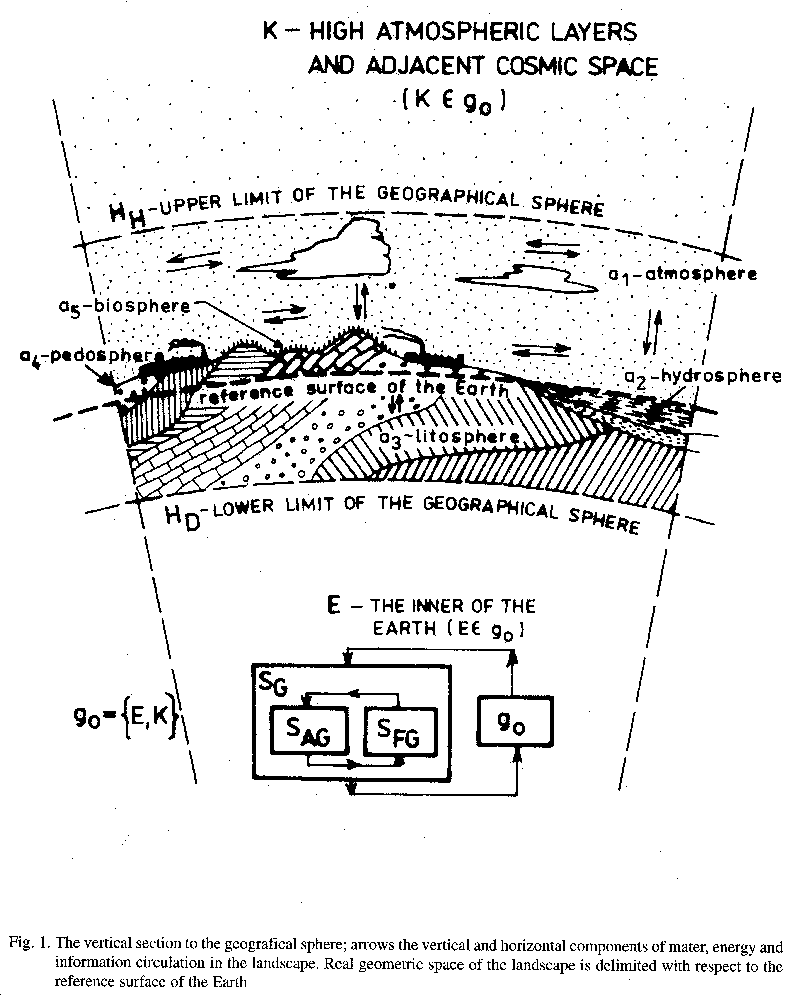
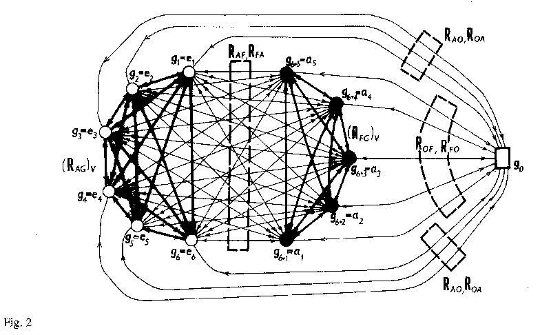
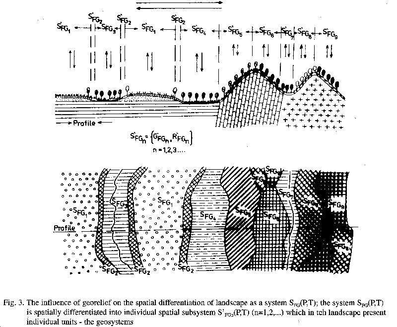
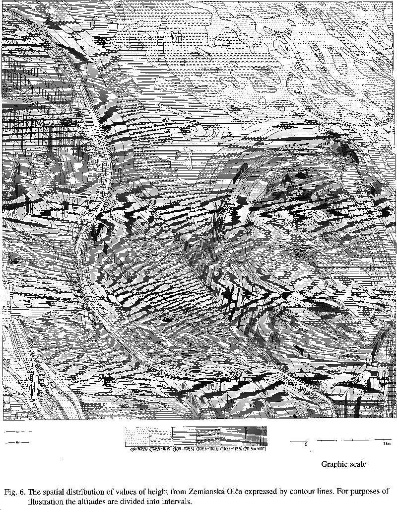
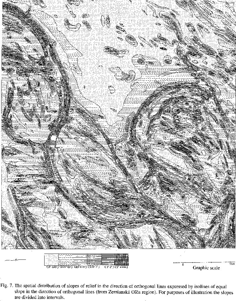
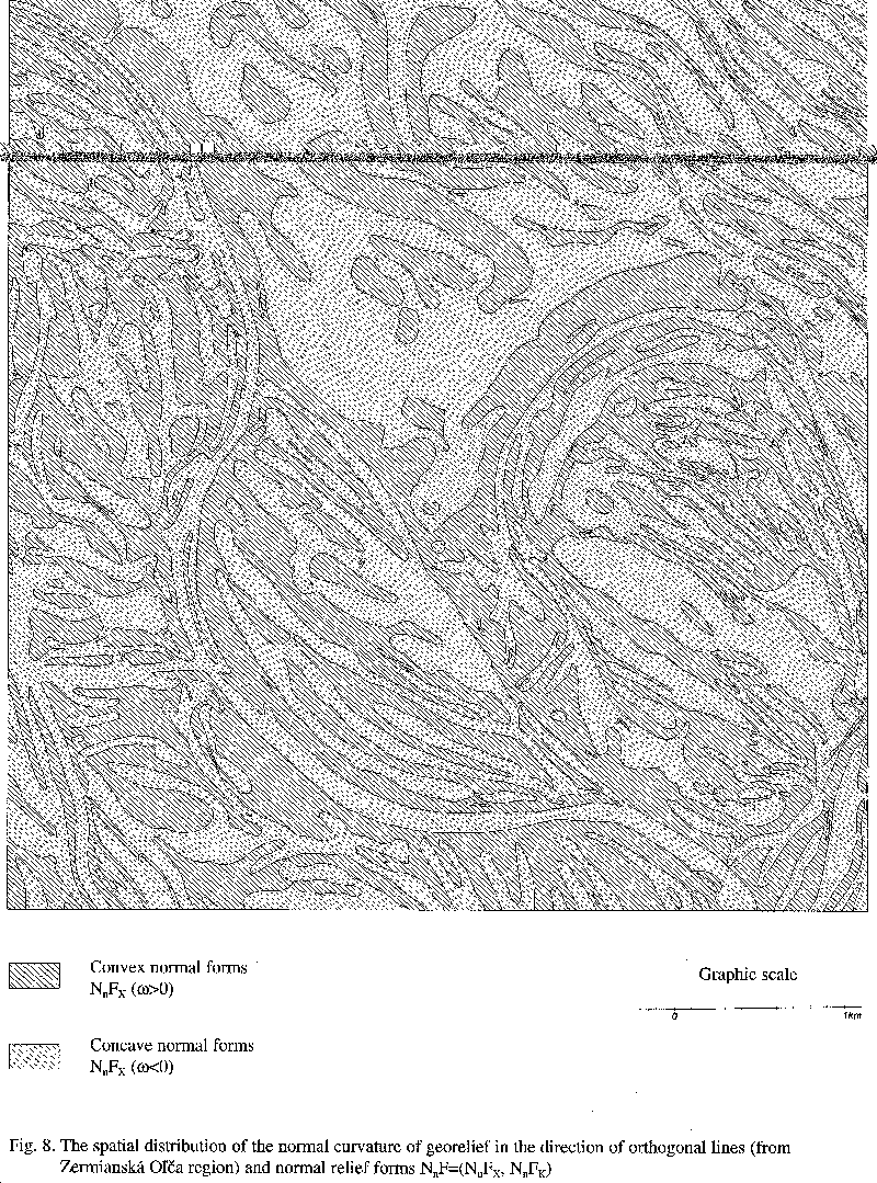
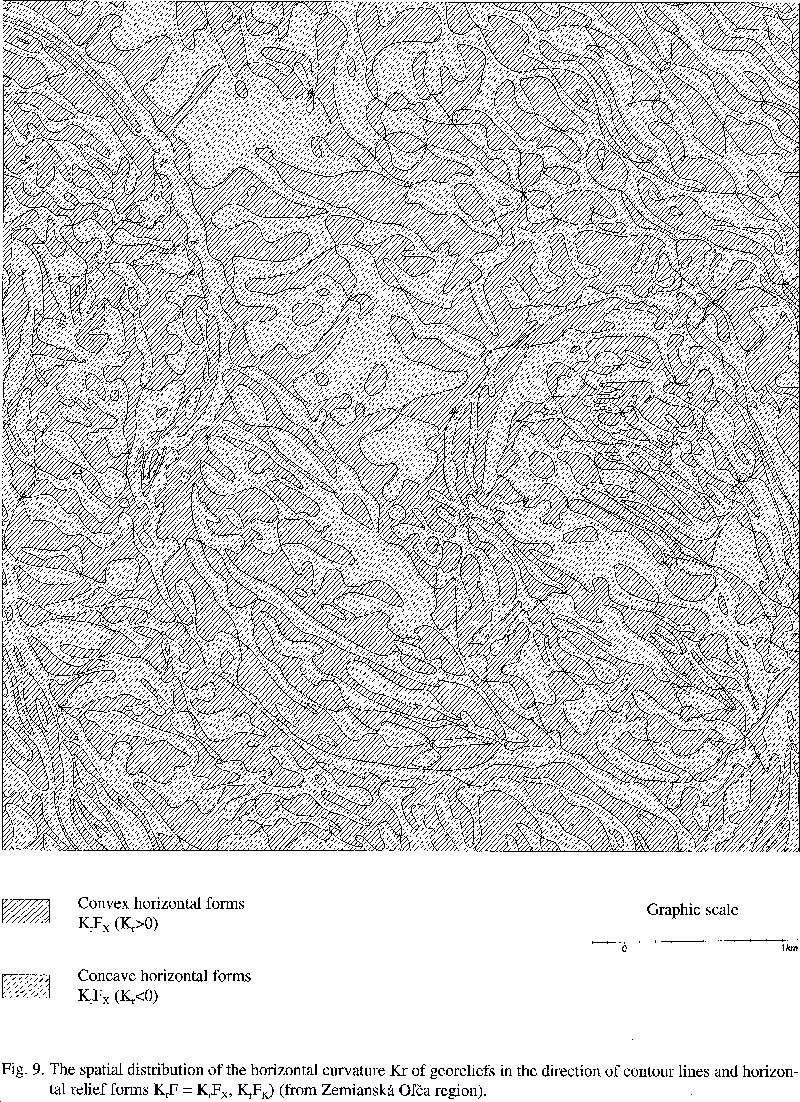
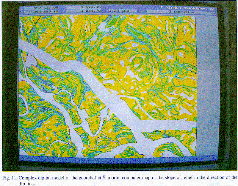
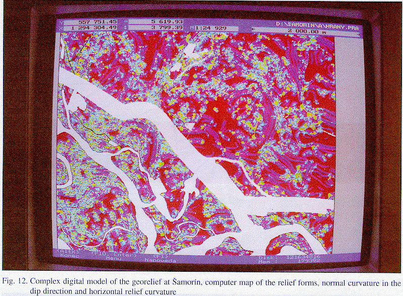
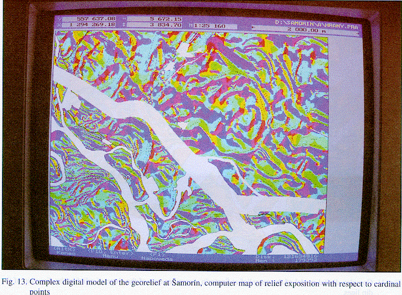
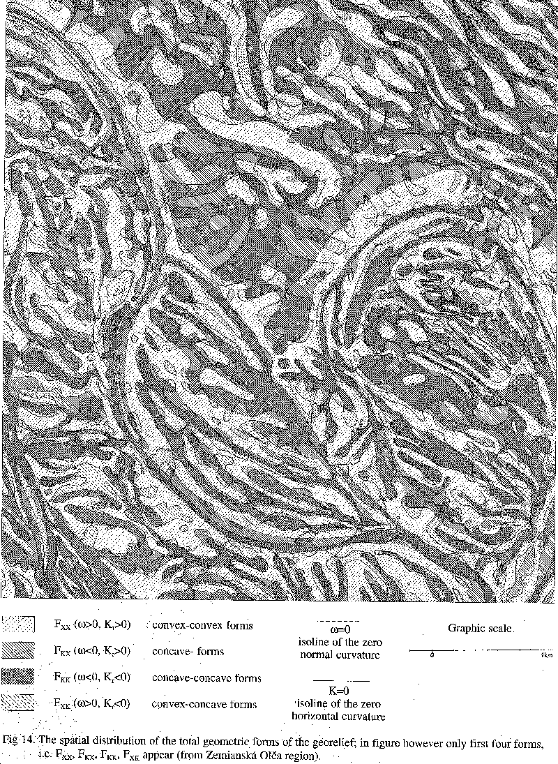
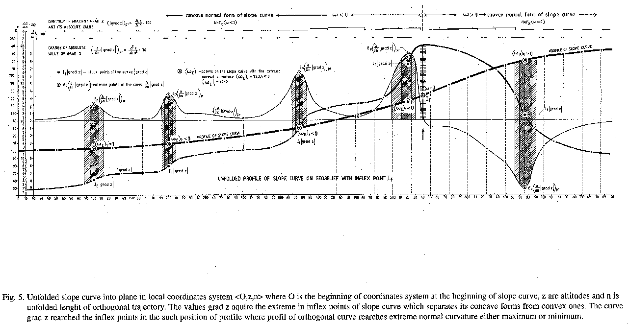
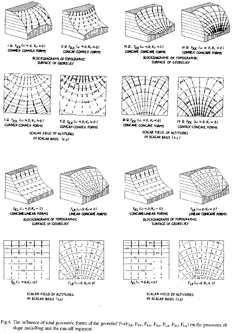
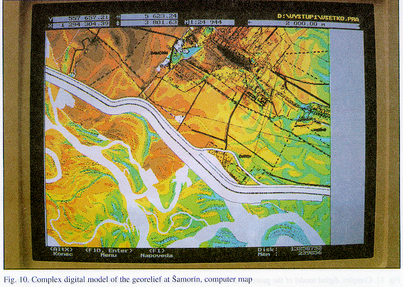