CONCLUSIONS By setting to operation the intake structure at Dobrohost and establishing culverts in the river arm system there were created conditions for preservation, and implementation of a optimal hydrological regime in the inundation area. It is possible to summarise principles of the manipulation order as follows:
The second qualitative break in the tree composition was recorded at the end of twenties, when domestic poplars were replaced to a prevailing degree by cultivar euro-american poplars. Without the change of the forest area extent, production increased almost twice during the last 40 years. Exploitation of wood increased from original 36 % to 94 % by silviculture of high-productive and resistant clones of poplars. We can again expect qualitative changes in this territory because of introducing a set of hydrotechnical measures at the beginning of May 1992.
The character and dynamics of changes are necessary to monitor until the values characterising natural conditions of this territory are stabilised. This will last according to our estimate 4-5 years.
From the above-mentioned facts, it is clear, that a sufficient supply of the inundation territory by water is dependent, except discharge in the old river-bed, mainly on manipulation on the intake structure and on individual lines in the river arm system. The aim of the observation of influence is to obtain such data, on base of which it will be possible to elaborate an optimal, eventually compromise, manipulating system for all spheres of interest in the inundation area. To put together such a system it is inevitable to take into consideration also a technical solution of the compensation water-supplying structures.
The hydrological regime of the old river bed was changed in the stretch from rkm 1811 up to the place of damming the Danube river at rkm 1851.75, turning aside part of its flow to the by-pass canal (power canal( with following utilisation of water for the production of electric energy by the hydropower station at Gabcikovo. Only sanitary discharge flows into the old river-bed. Except this into the old Danube flows discharge overtaking the capacity of the power station, and eventually discharge when passing ice-blocks from the reservoir. The level in the old river-bed is as a consequence of small discharge essentially lower so that it is impossible to water the arm system without additional measures. The old Danube river bed by its draining effect lowers the water level in the river arms to such a degree, that some stretches would remain empty without watering the river branches from the reservoir. This was done by the construction of objects for water supply to the left-side arm system and by the construction of dike lines in the inundation area.
The collection of data was made with one-week step, if necessary also twice per week. The ground water level was measured in observation wells (drilled to depth of 6 m).
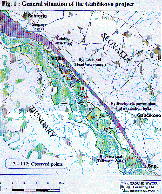
The distribution of monitoring points L3-12 is indicated on the map. Monitoring points L3 and L4 are not affected by manipulations in the river arm system. They are situated under the estuary of the Bakanske rameno arm at the old river-bed and they are influenced by the back water effect of the tail race canal. It is possible to create a suitable groundwater level from the point of view of the forest management, except to places localised in the near-bank belt of the old river-bed (approximately 50 - 200 m - monitoring plots L10 and L11), where the groundwater level decreases up to 3 m and is fully dependent on the water level in the old river-bed.
Suitability of hydrological conditions in the inundation area is testified also by height and thickness increments of trees (see Table), measured on the observation plots since 1990. 30 and registered trees, 1.3 m high, are measured in every monitoring area. The last measurements were made in January 1994. Above-normal high increments in areas L4 and L12 were caused by disappearing weaker individuals during the snow calamity in the winter period 1993/1994. The hydraulic interconnection between the groundwater level and the water levels in the river arm system in dependence on water levels in the old Danube river-bed and in dependence on the discharge via the intake structure from the reservoir is important from the standpoint of the operation of the intake structure. According to realised measurements it is possible to suppose, that a necessary groundwater level is possible to reach also at smaller discharges, by closing the gates of the culverts at the compartments lines. This fact is necessary experimentally to test and further optimise.
Principles of the management could be summarised as follows:
This low stand of water levels is necessary to preserve until the beginning of the vegetation period (approximately up till the end of February), in connection with a developing trend of the air temperature and the amount of precipitation. It is possible to suppose, that required water level in compartments is possible to reach also at lower discharges via the intake structure by manipulation on culverts. Further optimisation of water levels is necessary to determine on the base of exact observations.
Tab. 1. Basic characteristics of monitored plots
| No. | Forest mana- gement unit | Stand | Tree composition | Set of forest types | Group of forest types | Soil type | |
|---|---|---|---|---|---|---|---|
| species | % | ||||||
| 1 | Gabcikovo | 331 e | oak black locust | 78 22 | nutritious set "c" | UFrc-100% | cl FMm |
| 2 | Gabcikovo | 330 b | cult. poplar "I 214" | 100 | nutritious set "c" | UFrc-100% | cl FMm |
| 3 | Gabcikovo | 90 b | willow | 100 | nutritious set "c" | SAL-100% | cl FMm |
| 4 | Gabcikovo | 84 g1 | cult poplar Robusta | 100 | nutritious set "c" | QFr-100% | cl FMm |
| 5 | Gabcikovo | 63 g1 | cult poplar "I214" | 100 | nutritious set "c" | QFr-100% | cl FMm |
| 6 | Gabcikovo | 79 p1 | cult poplar Robusta | 100 | nutritious set "c" | QFr-100% | cl FMm |
| 7 | Samorin | 55 d2 | cult poplar Robusta | 100 | nutritious set "c" | QFr-100% | cl FMm |
| 8 | Samorin | 49 r1 | cult poplar Robusta "I 214" | 100 | nutritious set "c" | QFr-100% | cl FMm |
| 9 | Samorin | 53 h | cult poplar "I 214" | 100 | nutritious set "c" | UFrp-100% | cl FMm |
| 10 | Samorin | 47 a | cult poplar "I 214" | 100 | nutritious set "c" | UFrp-100% | cl FMm |
| 11 | Samorin | 46 a | cult poplar Robusta alder | 70 30 | nutritious set "c" | QFrp-100% | cl FMm |
| 12 | Samorin | 33 f2 | cult poplar "I 214" | 100 | nutritious set "c" | UFrp-100% | cl FMm |
Tab. 2 Average biometric values and increments in individual years
| Year | OBSERVATION POINT | |||||||||||||||||||||||
|---|---|---|---|---|---|---|---|---|---|---|---|---|---|---|---|---|---|---|---|---|---|---|---|---|
| L1 | L2 | L3 | L4 | L5 | L6 | L7 | L8 | L9 | L10 | L11 | L12 | |||||||||||||
| d1,3 | h | d1,3 | h | d1,3 | h | d1,3 | h | d1,3 | h | d1,3 | h | d1,3 | h | d1,3 | h | d1,3 | h | d1,3 | h | d1,3 | h | d1,3 | h | |
| 1990 | 27.5 | 27.0 | 41.3 | 27.7 | 32.2 | 22.0 | 22.7 | 24.0 | 35.8 | 30.5 | 35.3 | 28.0 | 33.4 | 34.0 | 26.0 | 25.0 | 46.0 | 35.0 | 32.4 | 23.0 | 47.2 | 42.0 | 23.0 | 24.0 |
| 1991 | 27.7 | 27.5 | 42.4 | 28.1 | 33.7 | 23.3 | 24.6 | 24.6 | 38.4 | 31.3 | 36.8 | 29.0 | 32.7 | 34.5 | 27.2 | 26.3 | 47.7 | 36.3 | 35.0 | 24.0 | 48.0 | 43.3 | 23.5 | 24.4 |
| 1992 | 27.8 | 27.8 | 42.8 | 28.5 | 34.4 | 24.1 | 26.0 | 25.5 | 41.9 | 31.8 | 37.5 | 30.7 | 34.8 | 35.3 | 28.0 | 28.5 | 49.1 | 36.6 | 37.5 | 24.9 | 49.1 | 43.6 | 24.2 | 24.4 |
| 1993 | 28.5 | 28.2 | 44.2 | 29.3 | 37.2 | 24.9 | 29.0 | 28.7 | 42.8 | 32.7 | 39.6 | 32.3 | 35.8 | 36.0 | 29.7 | 29.8 | 49.7 | 37.0 | 39.0 | 26.2 | 49.8 | 43.8 | 28.2 | 24.4 |
| ANNUAL INCREMENT | ||||||||||||||||||||||||
| 1991 | 0.2 | 0.5 | 1.1 | 0.4 | 1.5 | 1.3 | 1.9 | 0.6 | 2.6 | 0.8 | 1.5 | 1.0 | 0.6 | 0.5 | 1.2 | 1.3 | 1.7 | 1.3 | 2.6 | 1.0 | 0.8 | 1.3 | 0.5 | 0.4 |
| 1992 | 0.1 | 0.03 | 0.4 | 0.4 | 0.7 | 0.8 | 1.4 | 0.5 | 3.5 | 0.5 | 0.7 | 1.7 | 2.1 | 0.8 | 0.8 | 2.2 | 1.4 | 0.3 | 2.5 | 0.9 | 1.1 | 0.3 | 0.7 | 0.0 |
| 1993 | 0.7 | 0.4 | 1.4 | 0.8 | 2.8 | 0.8 | 3.0 | 3.6 | 0.9 | 0.9 | 2.1 | 1.6 | 1.0 | 0.7 | 1.7 | 1.3 | 0.6 | 0.4 | 1.5 | 1.3 | 0.7 | 0.2 | 4.0 | 0.0 |