CONCLUSIONS The evaluation of trends of the vegetation development is based on the monitoring of forest phytocoenoses at 12 monitoring areas during the years 1990-1994. Conditions of forest ecosystems differentiate according to local factors and the location of the area of interest. These are the following types of monitoring areas:
I relatively stable areas, e.g. Erced, Stary les, Kralovska luka, Rusovske ostrovy 2B, Bodicka brana, Ostrovne lucky 3C;
II areas subjected to more or less remarkable changes with the characteristic of
Vegetation monitoring is directed at the documentation of conditions and changes of vegetation in relation to changes of environmental parameters (mainly hydrological and pedological ones) and to the time factor. This study was undertaken in order to register the botanical value of the monitoring areas from the floristic and phytocenological point of view and to establish a network of permanent investigation areas for repeated phytocenological (semi-quantitative) and population-ecological (quantitative) observations.
The monitoring of vegetation was methodically divided to three basic hierarchic levels, e.g. the monitoring of vegetation under macro-, meso- and microstructures [12]. Annual observations over the period 1990-1994 at 12 localities consisted of semi-quantitative recordings of forest phytocoenoses and the quantification of plant populations of herb undergrowth at the same permanent monitoring area.
Based on the monitoring of forest phytocoenoses at 12 monitoring areas, they can be divided into relatively stable, or less changing areas and to areas with more or less marked alterations. These are reversible, but occasionally even irreversible. Some places are affected by synergetic activity of several factors, e.g. ground water level and floods, as well as emissions from Bratislava city, nitrification and other anthropogenic influences.
Monitoring area (MA) Erced is localised at the level of the tail-race water canal and the Danube old river-bed confluence. Water regime with natural fluctuations reflects the dynamics of the Danube water level. This was manifested in 1993 (a year after damming of the Danube) by the flooding of the locality with surface water. Although in 1994, this situation did not repeat, the vegetation cover was substantially supplied by capillary water (during vegetation season the water level did not drop below 1.3 m, in spring being about 0.4 m under the surface, according to our estimation in the absence of the measuring instrument). Forest cover, with its spring herb undergrowth dominated by a precious species Leucojum aestivum, shows stable values of followed parameters among individual years. These are: cover capacity of tree and herb layers, total number of species, values of ecological analysis, as well as the index of similarity according to Jaccard. The population of Leucojum aestinum, which is an endangered species of Slovak flora was used as an index of drenched soils [2], is vital, growing, annually blooming and fertile, thus indicating balanced ecological conditions at the locality.
At MA Stary les, development of forest cover is represented by an association of Salici-Populetum [5] creating only strip of shore cover in the vicinity of the weir, and is relatively stabilised. In 1993, even at the beginning of summer, surface seepage water occurred in country depressions as well as in a cut-off arm, while in 1994 this situation did not repeat. However, this fact is considered a demonstration of the natural dynamics of the floodplain ecosystem. In the monitored forest cover original species dominated and a neophyte Aster novi-belgii was also introduced. The cover capacity of the herb layer is 100%, ans is in reach during whole monitored period, while that of the tree layer decreased a little in the year 1994. The values of other parameters are stable (Tab. 2).
MA Rusovske ostrovy 2B. In this locality (in contrast to part 2A) a favourable influence of damming was noted in 1994. It was manifested by an infiltration of ground water in a direction out of the dam, as is evident from the basic data on the development of isohypses and the filling of a country microdepression with vegetation cover. The conditions of the monitored forest cover represented by the transitional floodplain Fraxino-Populetum association [5] has stabilised. Irregular floods of habitat which are characteristic for this type of forest occurred last in the summer of 1991. As a consequence, a number of species temporarily decreased, however, in 1993 and 1994 it returned back to its original value (Tab). The cover capacity of the tree layer moderately decreased, especially in 1993 when several tree branches became transparent and died away. Shrub layer is permanently well bound and wooden plants regenerate, mainly the neophytic species Acer negundo. This area belongs to those that are less changing [3].
MA Kralovska luka. Despite the fact that the monitored forest cover of Salici-Populetum association was not flooded by surface water in 1993 and 1994, there are stabilised conditions of humidity in this area. This is a result of favourable soil granulation (e.g. clay soil), (Cambel in [7]), which keeps even a superfluous amount of water at all layers that are important for plants (0.2 - 1.5 m) according to the monitoring of the volume humidity of the soil during the whole vegetation season [1]. Willows were up till now well leafed, herb undergrowth was rich, even vigorously developed. A different trend of development is becoming apparent in a part of a country depression, where in 1994 a number of species that serve as indicators of drenching had decreased, while a number of nitrophile species that do not require such high humidity had increased (Utrica dioica). Another part of the area, dominated by herb undergrowth the neophyte Aster novi-belgii is stabilised, since this species is strongly concurrent and covers the territory entirely.
MA Ostrovne lucky 3C. Phytocenosis of Ulmo-Fraxinetum association, a type of hard-wood floodplain, was monitored in 1990 and 1994. There are no big qualitative and quantitative changes of cover apparent in this area, therefore its development could be considered stabilised [3]. The area is localised near the water source for the Petrzalka district and within a reach of favourable influence of dam seepage.
MA Bodicka brana. The monitored cover of cultivated poplar was not flooded in the years 1993 and 1994, in contrast to preceding years. According to our findings, the ground water was very low during these years - in spring being at a depth of about 3 m, in summer even at about 4 m. In comparison to the year 1990, volume humidity dropped in those layers that are most important for vegetation (e.g. 0.2 - 0.4 m) from the end of May until the end of October by about 10%, while at the depth of 0.8 m in July and August by about 20% [4]. Up till now, no changes in vegetation have become apparent in a global context. However, based on the similarity of data from 1990 and 1994, when Jaccard's coefficient had reached a value of only 36.8%, it can be concluded that the species spectrum had changed in favour of some nitrophile species and grasses. The absence of floods is the main limiting factor in this area. Floods are needed in the summer months to supply moisture deficit, since even the filling of river side-arm system did not improve humidity conditions in this part of the monitoring area, which is influenced by the drainage of the old river-bed of the Danube. If such floods will not occur during 1995, the dying away of poplars, cover enlightenment and the continuation of successive changes could be expected in the area which is not influenced by the supply of the river side arm system with water. However, this is relevant only for a small part of the inundation area.
MA Horna vrbina. The monitored part of the area consists of the Chelidonio-Robinion alliance of secondary acacia cover in the undergrowth with both original and neophytic species. The species composition of wooden plants is to a considerable extent not original, with prevailing cultivated poplar, acacia, and Box-elder, and also is mixed also with original wooden plants of floodplain forest, such as white willow and original poplar species. Since 1993, the area has been influenced by the selection of trees, especially poplars. The cover of dominating acacia was formed as a result of exploitation. Subsequent cover enlightenment and the decrease of the cover capacity of tree layer were reflected also by the values of recorded data similarities according to Jaccard. The similarity between the years 1992 and 1994 is only 37.5% (Tab.3), witnessing changes in composition of species, that is manifested by a decrease of the total number of species by 8. The cover is considerably synanthropized, the herb layer dominated by neophytic species Solidago gigantea requiring much light [2]. Although an increase of the ground water level was noted in broader reservoir surroundings in 1994, the development of cover was not affected from a phytocenological point of view. The area was influenced mainly by anthropogenic intervention in 1993 and its continuation at the beginning of 1995 by further selective chopping. Therefore, the locality is becoming less valuable, even invaluable for monitoring the influence of hydropower structures and other water engineering works, since it will be impossible to differentiate between these two effects. Moreover, there is no direct data on the dynamics of the ground water level and soil moisture.
MA Klucovec was made into a control area for comparative purposes. It is localised below the estuary of the tail(water canal to the old river-bed of the Danube. As a consequence of unsolved legislative protection of this area, in 1991 it was afflicted by strong standardising selection of poplars. Due to cover enlightenment and the absence of floods in the last two years, this area of transient floodplain was subjected to regular, sequential changes, e.g. better development of shrub vegetation (recovering of Populus alba, Ulmus sp., Euonymus europaea and neophyte Acer negundo) and huge development in herb vegetation represented rather by nitrophilie species (Utrica dioica) as well as by neophytic species (Solidago gigantea, Impatiens parviflora). The monitoring of volume moisture of the soil in the years 1990 and 1994 [4, 1] revealed that the upper layers (at a depth of 0.2 - 0.4 m) were more humid than the lower ones (at a depth of 0.5 - 0.8 m) and that they were dependent on floods and precipitation during the major part of the year. In the dry year of 1994, that was affected in addition by the absence of floods, the values of volume moisture were already within the range of 4.8 - 34.5% by the middle of July the lowest values being recorded on 11th August, e.g. 3.9 - 23.6%. During that period, soil water was hardly accessible by plants, even out of their reach, at a depth of 0.6 - 0.8 m. This situation held out until the end of October. In the upper layers (up to 0.4 m), volume moisture had begun to rise since the middle of August in connection with precipitation. The trend of development of the soil moisture is the same as trends in preceding years (drop in humidity during summer months). Although this area is of a transient floodplain type, occasionally floods are needed there.
Monitoring areas Kopac, Rusovske ostrovy 2A, Topolove hony. These areas show destruction of cover, dying away and falling out of adult standard trees, premature falling of leaves of wooden plants, a trend of sequential and long-term alterations of the whole phytocenosis and the fading of herb vegetation in the summer months. This trend of development has a previous long-term character, since the destruction of hydropedological conditions had already begun in 60-ties. The increase of the ground water level at these localities situated at the reservoir upstream Cunovo structures was not manifested in followed phytocoenoses until now. Furthermore, emissions from Bratislava (mainly Slovnaft and the garbage combustion plant) act as a stress factor, that could not be neglected [3]. However, this factor is not followed in the frame of monitoring and thus its participation in the negative trend cannot be exactly expressed. Only further development during the next few years will show whether the changes are already irreversible, with respect to the age of covers, or whether they still have the capacity to regenerate.
MA Dobrohost. The negative trend of development in the monitored cover of soft-wood floodplain (of rather dry type) became apparent after changing the flow direction of the Danube water to a bypass canal, followed by the drying of biotope due to altered hydrological regime. The decrease of the ground water level has been recorded since 1993 (it stabilised in the vegetation season of the year 1994) simultaneously with the decrease in the volume moisture of the soil. In layers down to 0.4 m, the trend of soil moisture was analogous to the course of precipitation from the beginning of May until the end of the third decade of October. Recorded values dropped below 10% and thus the soil water became limited and hardly accessible for vegetation (with minimum values from 11.8 to 13.9). In layers of 0.6 - 1.5 m depth, values of volume soil moisture were decreasing moderately from May to October (from 15 - 25% to 10 - 16%) and were totally lower in comparison to the year 1990. As a result, soil water was within limited reach of plants [6]. The unfavourable course of humidity could be influenced only by surface flood of the country which, however, occurred last in 1991. This development is a result of the enlightenment of wooden plants (willows and poplars), dying away of tree branches and whole trees. In the year 1994, the number of willows reduced to 45% [10]. In the year 1993 the number of individuals of Leucojum aestivum decreased, that serves as an indicator of drenching and floods. Also the spectrum of species has changed, as evidenced by a 50% value of Jaccard's index of similarity between the years 1990 and 1994 (Tab.3).
The forest environment at the monitoring area MA Istragov consists of typical riverside flooded willows. As a subject of monitoring it is of soft-wood floodplain cover of the Salici-Populetum association. In 1990, pedotop was characterised by the high dynamics of ground water level that periodically contacted the soil profile and regularly flooded the locality. The level of ground water did not drop below 3m. The last flood occurred here in 1991 and then the hydrologic regime of locality changed after the damming of the Danube. In 1993, the ground water level was approximately about 2.7 m deep and during the vegetation season of the year 1994 it dropped below 3 - 3.5 m. The decrease of volume in the soil moisture started at all layers from the beginning of July up to 1.6 m, during August reached a value of 4.8 - 19.8%, and in September 3.7 - 15.7%. These levels are considerably lower than those in 1990 (by about 7 - 30%). Due to this decrease, soil water became limited and within a hard reach of vegetation. These altered conditions were only slightly reflected by the vegetation in the decrease of cover capacity of some more hydrophytes species, and a drop in the ecological value of humidity and an increase in the dominance of nitrophile species. However, in 1994, these changes became more marked - the spectrum of species decreased in comparison with the preceding year by 7 species. Especially affected were those species that serve as indicators of drenching and soil moisture. Cover capacity of other hydrophytes species also decreased. This is documented by values of Jaccard�s index of similarity, between the years 1990 and 1994 reaching only 35.9% and between 1992 and 1994 about 55%. The trend of the dominant position was strengthened by those species that do not require much moisture, e.g. nitrophile species and neophytes, such as Aster novi-belgii and Impatiens glandulifera. This is evidenced by increased numbers of individuals belonging to these populations and a decrease of individuals of original populations represented by Leucojum aestivum, Polygonum mite, Mysotis palustris and Carex sp. These data reveal a clear-cut trend of the drying out of biotope. In the case that hydrologic conditions will not improve in 1995 by several days of long flooding at least in the summer period, the reconstruction of relevant phytocoenoses and further terrestriation of arms and country depressions could be expected.
Willow cover of Salici-Populetum association in a terrain depression is the subject of monitoring at the area MA Ostrovne lucky 3A. Since 1990, this cover has been affected by qualitative changes that are documented by decrease of the total number of species of phytocenosis from 22 to 13 in 1994, and by the extinction of geophyta and the absence of the spring aspect. The dominating nitrophile species Utrica dioica and Galium aparine remain. The index of data similarity according to Jaccard is of decreasing tendency: between 1990 and 1991 reaching a value of 57%, between 1990 and 1994 only 45%. The filling of the dam in 1993 was accompanied by a water increase and its elevation was above the level of territory in the terrain depression of the bypass arm (up to height of 10 - 40 cm) for several weeks. This stagnant water had a favourable effect on the improvement of the leaf apparatus of dominating willow, without premature falling out. However, in 1994, humidity conditions were not as good as during the preceding year and the depressions were not flooded. Although the cover conditions, evaluated on the basis of loss of leaves, appeared to be very good [10], phytocenosis was subjected to further changes in species composition, since no significant favourable influence of dam seepage was noted in this area, up to now. The locality was at the same time affected by Slovnaft emissions and by other anthropogenic influences due to the close vicinity of settlement (some cutting of trees( and fields (increased nitrification caused by leakage from higher localised agricultural areas) [3].
On the other hand, a substantial increase of the ground water level above Cunovo dam was not significantly demonstrated at the localities of Kopac, Rusovske ostrovy 2A and Topolove hony. Emissions from Bratislava constitute a substantial stress factor in these areas. This factor is, however, not followed in the frame of monitoring and its effect could not be evaluated. Only next few years will show, whether the cover alterations are irreversible with respect to their age, or whether they are still capable of recovering. Furthermore, a gauge for the measuring of the ground water level has not been directly installed at the locality of interest. Installation of at least one such instrument is needed at the Rusovske ostrovy 2B area, as well as at Stary les or at the monitoring area Vojka-Zofin which was not included in the study before, but has increasing importance in connection with the drainage effect of the old river-bed of the Danube.
Anthropogenic intervention in the form of the selection of poplars appears to have a dominating effect on the areas Horna vrbina and partially also Klucovec. Since there is no possibility to differentiate between the effect of forestry and water engineering work, these localities have became less valuable, or even invaluable from the point of view of our monitoring. To avoid a similar situation at other localities, the legislative protection against such activities of foresters and new owners of forests is needed.
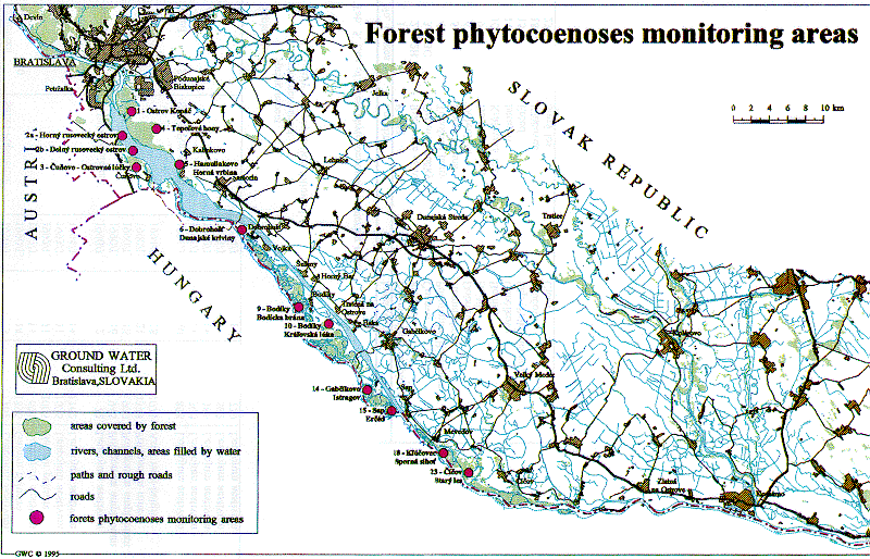
Fig. Forest phytocoenoses monitoring areas.
Tab. 1. An overview of monitored phytocoenoses at monitoring areas and their classification [8]
| locality | association | alliance | |
|---|---|---|---|
| Kopac | Fraxino-Populetum | Ulmenion | |
| Rusovske ostrovy | 2B 2A | Fraxino-Populetum Fraxino-Populetum | Ulmenion |
| Ostrovne lucky | 3A 3C | Salici-Populetum Ulmo-Fraxinetum | Salicion albae Ulmenion |
| Topolove hony | 4A 4C | Ulmo Qercetom convalarietosum | Ulmenion |
| Horna vrbina | alliance vegetation | Chelidonio-Robinion | |
| Dunajske kriviny | Salici-Populetum | Salicion albae | |
| Bodicka brana | Salici-Populetum | Salicion albae | |
| Kralovska luka | Salici-Populetum | Salicion albae | |
| Istragov | Salici-Populetum | Salicion albae | |
| Erced | Salici-Populetum | Salicion albae | |
| Klucovec | Fraxino-Populetum | Ulmenion | |
| Stary les | Salici-Populetum | Salicion albae |
Tab. 2. results of ecological analysis of forest phytocoenoses (1990 - 1994)
| Locality | Date | Average indicator values | |||||
|---|---|---|---|---|---|---|---|
| S | T | K | V | R | N | ||
| Kopac | 27.6.90 | 5.38 | 6.14 | 4.73 | 5.55 | 7.72 | 6.15 |
| 27.8.91 | 5.58 | 5.86 | 4.26 | 5.35 | 7.75 | 5.81 | |
| 15.7.92 | 5.50 | 5.68 | 4.04 | 5.14 | 7.72 | 5.57 | |
| 8.7.93 | 5.78 | 5.61 | 3.75 | 5.13 | 7.34 | 6.28 | |
| 7.7.94 | 5.02 | 5.71 | 3.76 | 5.29 | 7.16 | 6.48 | |
| Rusovske ostrovy 2B | 18.6.90 | 5.48 | 5.40 | 4.10 | 6.15 | 6.98 | 7.42 |
| 24.8.92 | 5.03 | 5.61 | 4.68 | 6.89 | 7.10 | 7.11 | |
| 17.8.93 | 4.80 | 5.79 | 4.61 | 5.91 | 7.06 | 6.78 | |
| 21.7.94 | 4.46 | 5.70 | 3.98 | 6.06 | 7.00 | 7.32 | |
| Ostrovne lucky 3A | 14.8.90 | 5.33 | 5.04 | 2.96 | 6.66 | 6.13 | 7.65 |
| 20.8.91 | 5.21 | 5.03 | 3.09 | 7.09 | 6.07 | 7.24 | |
| 25.8.92 | 5.50 | 5.12 | 3.10 | 6.86 | 6.14 | 7.56 | |
| 17.8.93 | 5.39 | 5.36 | 3.15 | 6.69 | 5.83 | 7.20 | |
| 13.7.94 | 6.06 | 5.02 | 3.00 | 6.87 | 6.01 | 8.03 | |
| 3C | 13.8.90 | 5.04 | 5.66 | 3.21 | 4.94 | 7.00 | 7.61 |
| 13.7.94 | 4.73 | 5.83 | 3.47 | 5.35 | 6.90 | 6.92 | |
| Topolove hony 4A | 15.5.90 | 5.82 | 6.65 | 3.77 | 4.78 | 7.66 | 4.40 |
| 21.8.91 | 5.72 | 6.54 | 4.03 | 4.24 | 7.67 | 4.24 | |
| 14.7.92 | 5.44 | 6.72 | 3.84 | 4.78 | 7.42 | 4.92 | |
| 8.7.93 | 5.41 | 6.66 | 4.00 | 4.84 | 7.54 | 4.99 | |
| 8.7.94 | 5.55 | 6.61 | 4.20 | 4.73 | 7.82 | 4.60 | |
| 4C | 2.7.90 | 6.65 | 6.16 | 5.50 | 4.91 | 7.90 | 4.97 |
| 8.7.94 | 5.77 | 6.21 | 3.70 | 4.66 | 7.62 | 5.99 | |
| Horna vrbina | 19.7.90 | 6.55 | 6.67 | 4.40 | 4.03 | 7.83 | 7.23 |
| 21.8.91 | 6.39 | 6.32 | 4.23 | 4.37 | 7.70 | 7.04 | |
| 27.8.92 | 6.15 | 5.99 | 3.94 | 4.37 | 7.84 | 6.57 | |
| 20.8.93 | 6.37 | 5.21 | 3.20 | 4.90 | 4.58 | 4.36 | |
| 19.8.94 | 6.74 | 5.30 | 4.03 | 5.00 | 7.53 | 6.80 | |
| Dobrohost 6b | 3.7.90 | 6.11 | 5.82 | 4.80 | 6.99 | 7.52 | 7.24 |
| 17.7.91 | 5.68 | 5.90 | 4.86 | 6.58 | 7.57 | 6.97 | |
| 18.8.92 | 5.91 | 5.83 | 4.83 | 6.73 | 7.55 | 7.00 | |
| 28.7.93 | 5.69 | 5.72 | 4.72 | 6.47 | 7.65 | 6.54 | |
| 3.8.94 | 6.21 | 5.51 | 4.23 | 6.85 | 7.45 | 7.42 | |
| Bodicka brana | 23.7.90 | 4.66 | 6.00 | 5.55 | 5.90 | 7.18 | 6.67 |
| 29.8.91 | 5.04 | 6.00 | 5.87 | 6.42 | 7.17 | 7.07 | |
| 7.7.92 | 4.37 | 6.00 | 5.27 | 5.37 | 7.00 | 6.37 | |
| 18.8.93 | 4.70 | 5.95 | 5.41 | 5.64 | 6.98 | 6.70 | |
| 3.8.94 | 4.59 | 5.98 | 5.45 | 5.56 | 6.99 | 6.67 | |
| Kralovska luka | 6.7.90 | 6.95 | 5.94 | 3.72 | 7.38 | 7.88 | 7.71 |
| 2.10.91 | 7.59 | 5.61 | 3.12 | 6.77 | 7.05 | 8.35 | |
| 7.7.92 | 7.15 | 5.99 | 3.52 | 7.35 | 7.72 | 7.69 | |
| 15.7.93 | 7.10 | 5.69 | 3.61 | 7.13 | 7.58 | 7.82 | |
| 3.8.94 | 7.06 | 5.74 | 3.96 | 6.92 | 6.97 | 7.78 | |
| Istragov | 26.7.90 | 7.20 | 4.75 | 5.35 | 6.97 | 6.50 | 7.92 |
| 2.10.91 | 6.16 | 5.42 | 4.17 | 8.40 | 6.28 | 6.23 | |
| 9.7.92 | 6.66 | 5.44 | 3.09 | 6.72 | 6.72 | 8.04 | |
| 15.7.93 | 6.72 | 5.59 | 2.91 | 7.11 | 6.38 | 7.55 | |
| 3.8.94 | 6.90 | 5.77 | 2.81 | 6.91 | 6.79 | 7.71 | |
| Erced | 15.4.92 | 5.17 | 5.22 | 3.15 | 8.01 | 5.27 | 6.09 |
| 12.5.93 | 5.76 | 5.96 | 3.62 | 7.80 | 6.49 | 6.60 | |
| 20.5.94 | 6.04 | 6.03 | 3.50 | 7.83 | 6.24 | 6.56 | |
| Klucovec | 26.7.90 | 5.17 | 6.28 | 5.75 | 6.28 | 7.71 | 6.53 |
| 9.9.91 | 5.32 | 6.25 | 6.05 | 6.40 | 7.50 | 6.89 | |
| 3.9.92 | 5.59 | 6.04 | 5.58 | 6.67 | 7.60 | 6.64 | |
| 8.9.93 | 6.32 | 5.51 | 4.44 | 6.20 | 7.35 | 7.53 | |
| 3.8.94 | 6.11 | 5.84 | 5.04 | 6.38 | 7.37 | 7.15 | |
| Stary les | 9.8.90 | 6.86 | 5.50 | 4.53 | 7.50 | 6.28 | 6.97 |
| 3.9.92 | 6.60 | 5.22 | 4.76 | 7.77 | 6.70 | 6.60 | |
| 8.9.93 | 5.58 | 5.28 | 4.66 | 7.71 | 6.78 | 6.74 | |
| 11.8.94 | 6.86 | 5.49 | 4.39 | 7.57 | 6.88 | 7.13 | |
Explanation:
Tab. 3. Similarities of the phytocoenoses according to Jaccard`s coefficient
| Locality | Years | Jaccard's coef. (%) | |
|---|---|---|---|
| Kopac | 1990/91 | 64.0 | |
| 1990/92 | 55.0 | ||
| 1990/93 | 51.0 | ||
| 1990/94 | 50.0 | ||
| 1993/94 | 42.0 | ||
| Rusovecke ostrovy | 2A | 1990/94 | 45.0 |
| 2B | 1990/94 | 35.0 | |
| 1993/94 | 50.0 | ||
| Cunovo | 3A | 1990/91 | 57.0 |
| 1990/92 | 36.0 | ||
| 1990/93 | 52.0 | ||
| 1990/94 | 45.0 | ||
| 1992/94 | 23.0 | ||
| 3C | 1990/94 | 65.0 | |
| Topolove hony | 4A | 1990/91 | 73.0 |
| 1990/92 | 63.0 | ||
| 1990/93 | 66.0 | ||
| 1990/94 | 59.0 | ||
| 4C | 1990/94 | 36.0 | |
| Horna vrbina | 1990/94 | 40.5 | |
| 1991/94 | 65.5 | ||
| 1992/94 | 37.5 | ||
| 1993/94 | 65.7 | ||
| Dobrohost | 1990/94 | 50.0 | |
| 1993/94 | 57.0 | ||
| Bodicka brana | 1990/92 | 58.0 | |
| 1990/94 | 36.8 | ||
| 1991/94 | 30.0 | ||
| 1992/94 | 42.0 | ||
| 1992/93 | 60.0 | ||
| 1993/94 | 55.5 | ||
| Kralovska luka | 1990/94 | 47.0 | |
| 1990/93 | 40.0 | ||
| 1993/94 | 64.2 | ||
| Istragov | 1990/94 | 35.9 | |
| 1992/94 | 55.9 | ||
| 1993/94 | 68.5 | ||
| Erced | 1992/93 | 47.6 | |
| 1992/94 | 50.0 | ||
| 1993/94 | 85.7 | ||
| Klucovec | 1990/92 | 48.1 | |
| 1990/94 | 35.1 | ||
| 1992/94 | 53.8 | ||
| 1993/94 | 61.5 | ||
| Stary les | 1990/93 | 45.7 | |
| 1990/94 | 52.9 | ||
| 1992/93 | 68.9 | ||
| 1992/94 | 61.3 | ||
| 1993/94 | 88.0 | ||
Tab. 4. selected characteristics of forest phytocoenoses at permanent monitoring areas
| Locality | Typ of phytocoenoses | Year / aspect | Number of species | Total number of individuals | Dominant species of area | |
|---|---|---|---|---|---|---|
| Kopac | 1 | Fraxino-Populetum | 1990/J | 5 | 992 | Ficaria verna |
| 1990/L | 28 | 1293 | Impatiens parviflora | |||
| 1991/L | 26 | 1279 | Viola odornata | |||
| 1992/L | 22 | 1717 | Impatiens parviflora | |||
| 1993/L | 24 | 1789 | Impatiens parviflora | |||
| 1994/J | 19 | 1353 | Stellaria media | |||
| 1994/L | 24 | 864 | Impatiens parviflora | |||
| Rusovske ostrovy | 2A | Fraxino-Populetum | 1990/J | 8 | 2561 | Glechoma hederacea |
| 1990/L | 21 | 517 | Impatiens parviflora | |||
| 1994/J | 19 | 3620 | Ficaria verna | |||
| 1994/L | 19 | 687 | Impatiens parviflora | |||
| 2B | Fraxino-Populetum | 1989/L | 13 | 428 | Aegopodium podagraria | |
| 1990/J | 6 | 1723 | Ficaria verna | |||
| 1990/L | 15 | 2127 | Impatiens parviflora | |||
| 1991/L | 10 | 596 | Aegopodium podagraria | |||
| 1992/L | 13 | 863 | Aegopodium podagraria | |||
| 1994/J | 13 | 2947 | Ficaria verna | |||
| 1994/L | 13 | 345 | Aegopodium podagraria | |||
| Ostrovne lucky Cunovo | 3A | Salici-populetum | 1989/L | 13 | 10898 | Stellaria media |
| 1990/J | 1 | 4625 | Stellaria media | |||
| 1990/L | 13 | 4972 | Stellaria media | |||
| 1991/L | 11 | 884 | Urtica dioica | |||
| 1992/L | 10 | 344 | Urtica dioica | |||
| 1993/L | 10 | 586 | Urtica dioica | |||
| 1994/L | 5 | 174 | Urtica dioica | |||
| 3C | Ulmo-Fraxinetum | 1989/L | 14 | 776 | Viola suavis | |
| 1990/J | 3 | 182 | Asperula odorata | |||
| 1990/L | 17 | 959 | Viola suavis | |||
| 1994/J | 6 | 318 | Viola suavis | |||
| 1994/L | 19 | 690 | Viola suavis | |||
| Topolove hony | 4A | Ulmo-Quercetum | 1990/J | 4 | 246 | Polygonatum latifolium |
| 1990/L | 11 | 466 | Convallaria majalis | |||
| 1991/L | 17 | 1993 | Cornum mas | |||
| 1994/L | 12 | 555 | Impatiens parviflora | |||
| Horna vrbina | 5 | Cheliodonio-Robinion | 1990/L | 12 | 769 | Solidago gigantea |
| 1991/L | 6 | 432 | Solidago gigantea | |||
| 1992/L | 7 | 282 | Solidago gigantea | |||
| 1993/L | 18 | 357 | Solidago gigantea | |||
| 1994/L | 11 | 230 | Solidago gigantea | |||
| Dobrohost | 6B | Salici-Populetum | 1990/J | 2 | 58 | Leucojum aestivum |
| 1990/L | 8 | 516 | Phalaris arundinacea | |||
| 1991/L | 9 | 647 | Rubus caesius | |||
| 1992/L | 11 | 796 | Phalaris arundinacea | |||
| 1993/L | 11 | 1429 | Impatiens parviflora | |||
| 1994/L | 11 | 903 | Impatiens parviflora | |||
| Bodicka brana | 9 | Salici-Populetum | 1990/J | 6 | 1975 | Impatiens parviflora |
| 1990/L | 7 | 475 | Impatiens parviflora | |||
| 1991/L | 4 | 2255 | Galium aparine | |||
| 1992/L | 7 | 125 | Impatiens parviflora | |||
| 1993/L | 8 | 270 | Galium aparine | |||
| 1994/L | 7 | 174 | Impatiens parviflora | |||
| Kralovska luka | 10 | Salici-Populetum | 1990/J | 3 | 761 | Leucojum aestivum |
| 1990/L | 14 | 1896 | Galium palustre | |||
| 1992/J | 1+ | 694 | Leucojum aestivum | |||
| 1992/L | 11 | 1005 | Galium palustre | |||
| 1993/J | 11 | 1626 | Leucojum aestivum | |||
| 1994/J | 1+ | 1162 | Leucojum aestivum | |||
| Istragov | 14 | Salici-Populetum | 1990/J | 2 | 72 | Leucojum aestivum |
| 1990/L | 16 | 945 | Polygonum amphibium | |||
| 1990/L | 16 | 900 | Polygonum amphibium | |||
| 1990/L | 21 | 1375 | Polygonum mite | |||
| 1994/L | 18 | 1071 | Aster novi-belgii | |||
| Erced | 15 | Salici-Populetum | 1991/J | 10 | 898 | Leucojum aestivum |
| 1991/J | 1+ | 306 | Leucojum aestivum | |||
| 1992/J | 1+ | 386 | Leucojum aestivum | |||
| 1993/J | 1+ | 502 | Leucojum aestivum | |||
| 1994/J | 1+ | 770 | Leucojum aestivum | |||
Explanation:
Tab. 5. list of forest phytocoenoses monitorung areas
| No. of area | Locality | Land register |
|---|---|---|
| 1 | Kopac | Podunajske Biskupice |
| 2A, 2B | Rusovecke ostrovy | Rusovce |
| 3A, 3C | Ostrovne lucky | Cunovo |
| 4 | Topolove hony | Podunajske Biskupice |
| 5 | Horna vrbina | Hamuliakovo |
| 6 | Dobrohost | Dobrohost |
| 9 | Bodicka brana | Bodiki |
| 10 | Kralovska luka | Bodiki |
| 14 | Istragov | Gabcikovo |
| 15 | Erced | Sap (Palkovicovo) |
| 18 | Klucovec | Klucovec |
| 23 | Stary les | Cicov |