CONCLUSIONS Monitoring of soils of the Zitny ostrov area has confirmed that after setting the Gabcikovo project into operation there did not occur such changes in ground water level in the agricultural areas, which would give rise to negative changes in the ground water and the soil moisture regime, and would create negative changes in the soil quality and in the natural soil processes. The original soil moisture regime on the all soil monitoring plots has remained, and by that have preserved the original state of the other soil quality parameters, soil processes and development trends. Pre-dam conditions of agricultural production on the Zitny ostrov island remain unchanged, and in the region at the Cunovo reservoir agricultural conditions are improved.
The first stage, 1989-1992, characterises the so called starting state of the soil quality and processes in the soil. This means the soil characteristics before operation of the Gabcikovo project.
The second stage, after 1992, characterises the situation after putting the Gabcikovo structures into operation. This means the stage after the start of the changes in the hydrological and hydrochemical regime of the ground water, created by operating the Gabcikovo hydropower project.
A wide set of the basic physical and chemical soil parameters, pedogenetical processes, chemical compositions of the soil and the ground water, and crop production of the agricultural co-operatives were monitored during 1984 - 1991.
The soil samples were taken from 20 monitoring plots (Fig. 1). At each plot there is a pedological observation well, a well for soil moisture measurement, a hydrogeological well, and precipitation and irrigation gauging instruments. Observation objects are situated first of all in such regions where there were forecasted changes in the ground water levels after the construction of the Gabcikovo structures [5, 8, 4] and the possibility of changes in the concentration of salts in the ground water. At the monitoring plots, the following aspects were taken into consideration: morphogenetic-stratigraphic structure of the soil profile, depth of the gravel base, the ground water level and fluctuation, and content of salts in the ground water and in the soil. Monitoring data already allows us to evaluate the influence of the Gabcikovo project on the soil parameters, to forecast further soil development, and to compare the present state with the original one and with the previous prognoses.
In this contribution we present results of monitoring some of the soil characteristics which are decisively influenced by the hydrological and hydrochemical ground water regime, as for example the soil humidity, the extent and the quality of humus, and the salinity of the soil.
The monitoring territory is divided into three regions, according to previous prognoses of the ground water level changes:
In some areas the soil moisture and the soil moisture dynamics down to 1 m under the surface were not significantly changed (Fig. 3). The capillary rising ground water only slightly increased the total supply of soil water. Therefore the original soil moisture is preserved in the surface layer of the soil. As it is possible to see from Fig. 3, any water content in the layer 30-100 cm dynamic oscillates in the so called semiuvidic interval of the soil moisture, this means, between the hydrolimit field capacity up to the point of lowered accessibility (FC-PDA). Content of water in the arable layer (0-30 cm) is fully dependent upon precipitation, mainly in summer months. In the non-vegetation period soil humidity decreases to a semiarid interval (PDA-WP), and in the period of vegetation increases to semiuvidic interval (FC-PDA).
Another situation is in the soils where the cover layer is shallow and where the ground water level remains in the gravel base, which does not enable it to rise to the soil profile. Original conditions of the soil development were preserved here. Water regime of soils and chemical soil composition remained the same. This situation is in Fig. 4. From the stand-point of agricultural production conditions, the changed hydrological regime of the ground water, influenced by the Cunovo reservoir, is positive. The supply of good quality ground water for irrigation increased. The present higher ground water level (3-2 m) and its capillary rise is already accessible for numerous deeper rooting plants. This new situation of the soil water regime in the climatic dry region have also positively influenced the stabilisation of crops.
In the prevailing part of the monitoring localities (Mp 5-7, 9-14), capillary water rises into the soil profile. It is usually manifested by an optimal moisture regime about 1.0 m thick in the surface soil layer. It comes more frequently to a seasonal wetting and to the creation of reduction processes in the lower horizons of soils. Examples of a such a situation are in Fig. 5 and 6.
In the arable interval (0-30 cm) and the interval 30-100 cm of soil profile, the soil moisture is prevailingly in an optimal semiuvidic interval. This means that the soil moisture is between hydrolimits Field capacity and Point of lowered accessibility (FC-PDA) during the whole monitoring period. This moisture interval provides a continuous supply of accessible water and also sufficient soil aeration. In the summer dry months the soil moisture decreases to a semiarid interval, under the hydrolimit Point of lowered accessibility (PDA). In places where the ground water is situated in sandy or gravely layers (Mp 4,8), the soil water regime depends on precipitation. The soil moisture is low in the whole profile.
The territory influenced by the tail-race canal (Mp 10) is characterised by a higher oscillation of the ground water level, dependent on the water level fluctuations in the tail-race canal. The ground water level rises near to the arable layer for a short time and causes transitional wetting of whole horizons.
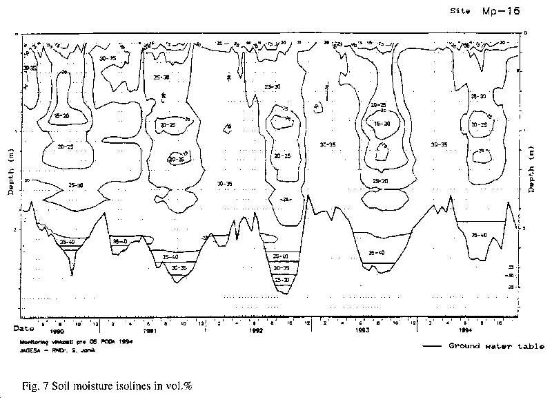
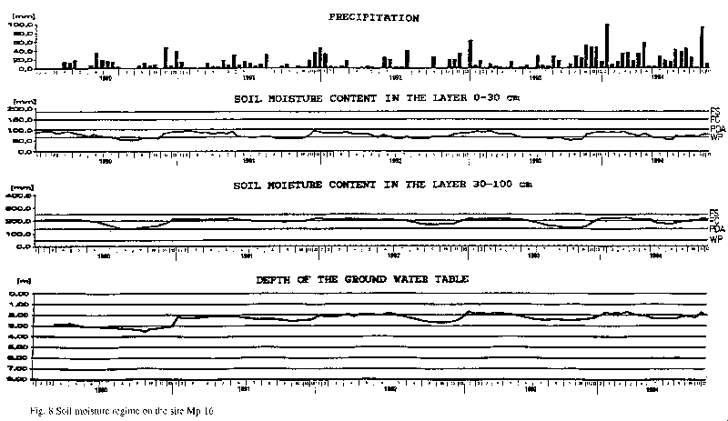
Soil humidity in the semiarid interval prevails in the arable horizon. At deeper layers it is in the optimal semiuvidic interval, between hydrolimits Field capacity and Point of lowered accessibility (FC-PDA). Examples of the water and the soil moisture regime in this region are in Fig. 7 and 8.
Humus is monitored in yearly intervals. The following characteristics are monitored: organic carbon (Cox), humine acids (HK), fulvoacids (FK), type of humus (HK/FK), coloured quotient (Q46) and ratio C/N. Changes of content and quality of the humus were expected first of all in the region of the by-pass canal as a consequence of the forecasted decrease of the ground water level and the soil moisture.
Conditions for the forecasted decrease of the humus content did not arise, because the ground water level and also the soil moisture regime were not essentially changed after realisation of the Gabcikovo project. Conditions for a gradual deterioration of the humus quality by a slight increase of more saline ground water level are still preserved.
Salinization is observed in all horizons of the soil on the monitoring plots in yearly intervals. In water extracts of the soil pastes, the following parameters are measured: conductivity (ECe), sodium (Na+), calcium (Ca++), magnesium (Mg++), the ratio of sodium absorption (SAR) and the percentage share of exchangeable sodium (ESP).
Results of the monitoring confirm that salinization of soils occurs also at present and this as a result of the increase of salt content in soil water and as an alcalinization process. The process of salinization is very weak, which is confirmed by the low values of electrical conductivity (ECe) of 2-4 mS.cm-1 [3].
The process of alcalinization is more visible, it is the content of sodium dependent upon the soil colloidal complexes (ESP). The content of 5-10 % indicates weak salting up of soils. This is recorded in a majority of the monitored soils every year, and this both before, and after, setting the Gabcikovo project into operation.
The main reason for the above-mentioned phenomena is that the ground water has an increased content of salt. Salt is than accumulated in the soil, bound on the soil colloidal complex.
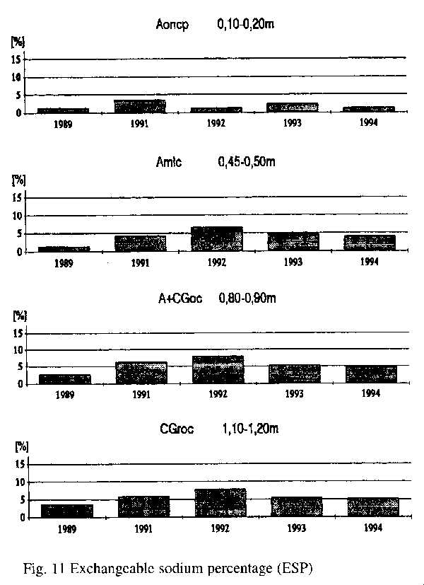
A slight trend of increase of salts in the water, mainly since 1991-1992, is visible. This trend is preserved also after setting Gabcikovo structures into operation. The example of weak salinization is expressed in Fig. 11..
Salinization of the soils on the Zitny ostrov island is known already from the works of Kyntera [9], Cervenka [1] and Hrasko [6, 7].