INFLUENCE OF GABCIKOVO HYDROPOWER STRUCTURES
ON THE DYNAMICS OF WATER IN THE AERATION ZONE
Julius SUTOR
Institute of Hydrology, Slovak Academy of Sciences, Bratislava, SLOVAKIA
CONCLUSIONS For the quantification of the influence of ground water level changes and fluctuation on water dynamics in the aeration zone the three following characteristics have been chosen:
- the course of cumulative water content in the aeration zone, monitored during the period 1990 to 1994
- quarterly averages of water content in the aeration zone in the period 1990 to 1994
- the quantification of the participation of individual soil horizons on cumulative water content in the aeration zone in given time intervals for selected typical monitored locations.
The negative changes of the ground water level after setting the Gabcikovo structures into operation as predicted by some authors, were not confirmed in the monitoring period (two years prior to setting the Gabcikovo structures into operation, one year during the transitional period, and two years after damming) and were not negatively reflected in the changes of water content in the soil zone of aeration.
INTRODUCTION.
The construction of the Danube Hydro-power Structures (HPS) affects the aeration zone (AZ) by changing the regime of the ground water level (GWL) compared to that without HPS. The consequences of the AZ changes are expressed by different amounts of water compared to that with the same conditions, apart from the dam. The GWL is the fluctuating surface defined by the pressure isobar that is equal to the atmospheric pressure. Water below this level is under tensiometric pressure and above it (i.e. in AZ) under negative pressure. For this reason changes in the GWL position or its fluctuation disturbs the equilibrium between the ground water level and water in the AZ. Water level increases disturbs the balance and water flow from ground water to the AZ, and vice versa. By this the GWL saturates the AZ during elevation and drains this water during its decline. It is important to mention that whilst water flow velocity in the Danube is expressed in kilometres per day and ground water in meters per day, in the AZ this flow is measured in centimetres per day. Therefore the decrease phase of the GWL fluctuation leaves water in the AZ, its outlet is relatively slower, and thus its longer presence in the AZ significantly affects the water supply for vegetation. Thus the monitoring of the water in the AZ was introduced for the purpose of obtaining information on retention and dynamic changes of water characteristics and water chemistry in the AZ in the Danubian Lowland territory, that is influenced by HPS. This information is needed for the evaluation of the impact of HPS on different parts of the environment, mainly: soil, agriculture, floodplain forests, phytocenosis and zoocenosis, water supply, and on selected types of ecosystems.
MONITORING METHODOLOGY
Method of estimation of water content in the AZ is based on organised monitoring of selected stationary stands with established time frequencies of measurements. Since 1990 monitoring has been organised along the Danube river reach, downstream from Bratislava to Komarno at the following localities (see also Fig. 1):
- Monitoring stands situated in the floodplain forests of the Danube inundation area:
- No. 17 - Dobrohost; No. 18 - Bodiky; No. 19 - Kralovska Luka; No. 20 - Dekan.
- Monitoring stands on agricultural soils:
- No. 7 - Klucovec; No. 5 - Zlatna na Ostrove; No. 9 - Trstena na Ostrove; No. 12 - Bac; No. 13 - Mliecno;
No. 14 - Kalinovska horaren; MP2 - Hamuliakovo; MP3 - Cilistov; MP5 - Sulany; MP8 - Baka;
MP10 - Gabcikovo; MP12 - Cilizska Radvan
- Monitoring stands on irrigated soils with the possibilities for penetration of irrigation water down to the GWL:
- N0 - N10 at Lehnice. expected water penetration through the AZ to the GWL.
STARTING-POINT FOR THE EVALUATION OF CHANGES IN THE AERATION ZONE
For quantification of changes in the water dynamics in the AZ of the Danubian Lowland after setting HPS into operation, data on the GWL that was published in [2, 3, 4] was used and the results thereof were provided to the author of this study by Prof. I. Mucha. It is documented that in the upper part of the Danubian Lowland (Lehnice location and Kalinkovska horaren location, that serve as indicators) there was an unambiguous increase in the GWL after damming the Danube. The decrease of the GWL was observed in locations downstream fromthe reservoir (down to Gabcikovo) and nearly no change (or a very small increase) is characteristic for the Calovo region. An additional increase in the GWL originated, even in the left bank territory at by(pass canal, after filling the river branch system with water.
As mentioned above, the Gabcikovo dam affects the water dynamics in the AZ by the changing level and fluctuation of ground water. It is possible to divide the monitoring into following time intervals:
- original condition, that includes water monitoring in the AZ before putting the Gabcikovo structures into opperation, i.e. before October 1992;
- transitional conditions, between the Danube damming and the opening of the intake object for the water supply of the river branch system at Dobrohost;
- non-stationary stay until operational conditions are not fully stabilised
- optimised operating conditions, including the determined regime of water distribution to the old river-bed, inundation, water level regulation, etc.
EVALUATION OF IMPACT OF WATER CONTENT IN THE AERATION ZONE
For the quantification of the influence of ground water level changes and fluctuation on the water dynamics in the aeration zone the three following characteristics have been chosen:
- course of cumulative water content in the aeration zone, monitored during the period 1990 to 1994
- quarterly averages of water content in the aeration zone in the period 1990 to 1994
- quantification of the participation of individual soil stratum on the cumulative water content in the aeration zone in given time intervals for selected typical monitored locations.
The complex study of all observation stations and intervening years is rather wide and was published in more detail in the author's reports [14-21].
Course of cumulative water content in the aeration zone, monitored during the period 1990 to 1994
Courses of integral water content in the AZ during 1990 to 1994 (except for the Kralovska luka location where monitoring took place for 9 years from 1986 to 1994) indicates the influence of the GWL changes and fluctuations. These time series covers above mentioned three periods of the Danubian Lowland environment development with respect to HPS: (i) original, (ii) transitional, and (iii) operational with continuing optimisation. Graphic presentation of these trends together with the trends of development in the locations of Bac and Dobrohost is documented in the Figs. 2 and 4. To enhance illustration, Figs. 3 and 5 describe the GWL trends at the same locations. For complex evaluation the data on the time series analysis of water content flow in the AZ together with data on the analysis of GWL courses are presented in Table 1.. The analysis of data from 10 locations show that the Gabcikovo structures caused an increase in the water resources in the AZ in all locations found in the territory of the left bank of the by(pass canal, whereas the GWL exhibits "statistical persistence", i.e. permanent tendency to decrease. It is possible to summarise that on the inundation territories of Dobrohost, Bodiky, and Dekan water content decrease occurred, however, though only in the location of Dobrohost was there water content decrease under the fade point during the summer months. At Kralovska luka (inundation area) there was a change from a decrease tendency to a moderate increase during 1993 and 1994 years. The same can be expected at the other two inundation territories, i.e. in Bodiky and Dekan locations. The most serious tendency of water resource decrease in the AZ occurred at Dobrohost where the effect of the decrease of the GWL is multiplied by the structure of the covering layer. The GWL moved down to the gravel layer resulting in disintegrated hydraulic contact between ground water and the AZ, i.e. the capillary connection had been cut. This phenomenon was not caused by extreme water decrease, but mainly by porous structure at the locality.
Negative changes as predicted by some authors, to the ground water level after the Gabcikovo structures were put into operation, did not occur during the monitoring period (two years before starting the operation, one year in the transitional period, and two years after damming) and were not negatively reflected in the changes of the water content in the zone of aeration.
Monitored courses of water content in the AZ responded sensitively to changes in the GWL which further confirms the important role of the GWL on the water balance in the covering layer and also the possibility of its regulation by the optimised operation of the Gabcikovo water engineering structures.
Quarterly averages of water content in the aeration zone in the period 1990 to 1994
The vegetation cover of the territory in the vegetation period (April - October) is supplied by water from the AZ. Water resources are limited by its recharge in the winter period. At the beginning and during the vegetation period it is possible to monitor the changes in the water resources in the aeration zone using the so called integral water content method.
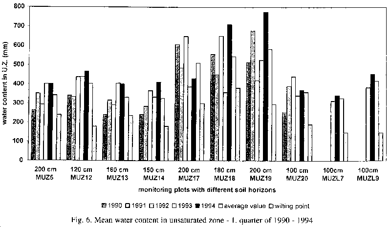
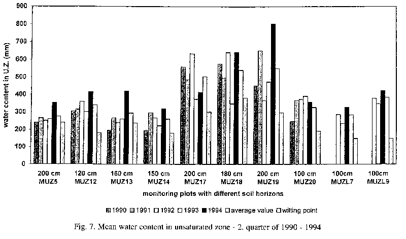
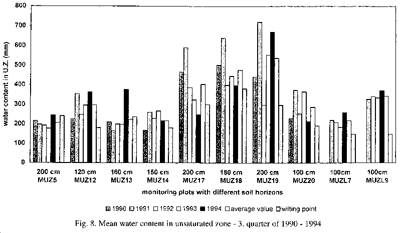
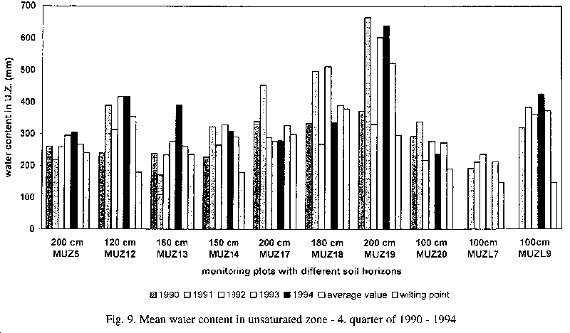
The autumn period is characterised by a depletion of water resources during the vegetation period and its recharge by precipitation at the end of year. For this reason data on water quantity in the zone of aeration taken from the five year period, 1990-1994, is presented by individual quarters of a year (see Figs. 6, 7, 8, 9). Plots of water content in the zone of aeration (data axis) vs. locality (category axis) are shown. Also attached to each graphical data representation from individual locations are averages for a quarter and the wilting point of the water amount (relevant to the type of soil at the given locality).
From the measured data it can be summarised that after putting the Gabcikovo structures into operation the average water content in the zone of aeration did not reach wilting point in any quarter of any year and the observed integral water contents in the upper part of the Danubian Lowland, in its central part and downstream from Gabcikovo are higher then former average levels. This also applies for the Kralovska luka location in the inundation territory.
Quantification of participation of individual soil horizons on cumulative water content
Cumulative water content in the AZ shows its overall resources. With respect to vegetation cover it is also important to have data on its vertical distribution. Furthermore, this distribution reflects the degree of stability of water resources at individual layers and its mutual interaction with the GWL. Irregular emptying of individual levels of aeration zones is documented by the distribution of the root systems of the vegetation cover and it also reflects the structure of porous medium of soils. This is why the analysis of water contents of individual layers has been accomplished. In this way the contributions of individual layers in the zone of aeration to the overall water content had to be evaluated.
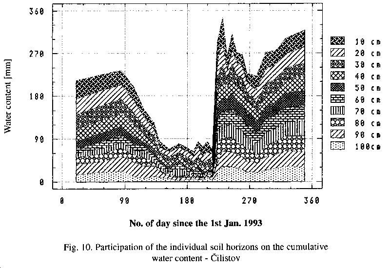
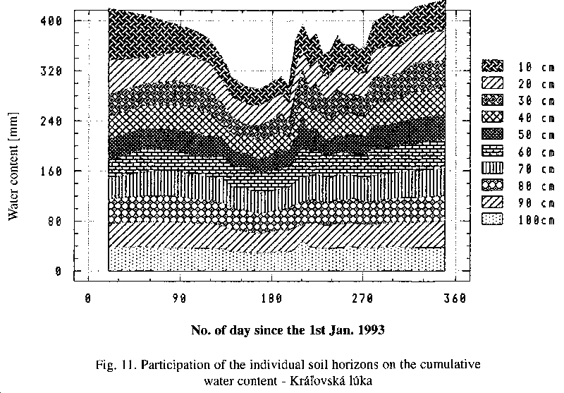
The monitoring of water content in the zone of aeration is based on the evaluation of soil moisture at 10 cm intervals from the soil surface to the required depth. As can be seen from Figs. 6, 7, 8, 9 this depth ranged at different monitoring stands from 100 to 200 cm. It is thus possible to use the analysis of individual levels of participation on water content on the whole monitored profile. In Figs 10 and 11 this type of analysis is documented for the localities of Cilistov and Kralovska luka.
Plots of water content in the zone of aeration (data axis) vs. day of count (category axis) are shown. Water content data in individual layers are gradually cumulated from the first (bottom) layer (at a depth of 200 cm at Kralovska luka locality) up to the soil surface. The additional data from the last layer data gives the cumulative water content of all layers. T observed water content in a given layer is expressed in mm of water. In such a way individually analysed quantities directly document the retention properties of individual layers in space and time. Analysis of the individual participation of layers on cumulative water content at Kralovska luka for the year 1993 documents the whole year's water supply from the GWL (Fig. 11). For the Cilistov location (Fig. 10) it is characteristic that during the extreme year 1993 water quantity gradually decreased until the Dobrohost intake structure had been opened. Thereafter a fast response in the form of water content increase was observed.
The analyses described above document:
- the sensitivity of water resources of the zone of aeration to the ground water level changes,
- inertia to sudden changes
- possibility of the optimisation of the water regime in cover layers in the inundation territory by changing the GWL and/or flooding the territory in the frame of operating the Gabcikovo structures
The three characteristics described above, i.e., (a) the course of cumulative water content in the aeration zone, (b) averages of water content in the aeration zone, and (c) the quantification of the participation of individual soil horizons on cumulative water content in the aeration zone of the cover layer of the Danubian Lowland environment, provide an unprejudiced basis for the evaluation of the impact of the Gabcikovo Hydro-electric power structures on the water content in the zone of aeration which serves as a water supply for the biosphere in the investigated territory.
REFERENCES.
- [1] Chalupka, J., Popelkova, Z., 1994: Influence of Gabcikovo water engineering structure on hydrology regime of ground water. In: Works and studies, 48, Monitoring of Gabcikovo water engineering structure influence on hydrologic regime of involved territory. SHMU Bratislava, pp.34-55. (In Slovak)
- [2] Mucha, I., et al., 1992: Optimisation of the finishing of Hydroelectric power structures Gabcikovo in the area of CSFR from the point of impact on the ground water. Ground Water Consulting, Faculty of Natural Sciences, Comenius University, Bratislava, March 1992, p.120. (In Slovak)
- [3] Mucha, I. et al., 1992: Danubian Lowland-Ground Water. PHARE Project. No.PHARE/EC/WAT/1. Workshop in Bratislava. June 10-13th 1992 b, p.91.
- [4] Mucha, I., - Paulikova, E., 1993: Gabcikovo water engineering structure influences on the ground water regime. Urbanity No.74, pp.77-83. (In Slovak)
- [5] Petrovic, P., Dzupova, D., 1991: Monitoring of the water regime and evaluation of evapotranspiration. Final report, VUVH, Bratislava, December 1991, p.81. (In Slovak)
- [6] Petrovic, P., Dzupova, D., 1993: Water regime monitoring and evapotranspiration evaluation. Final report, VUVH, Bratislava, February 1993, p.93. (In Slovak)
- [7] Pristachova, G., 1989: Gabcikovo-Nagymaros water engineering structure influences on quantitative water regime of agricultural and forest soils. Final report of subcontract. VUVH Bratislava, (In Slovak)
- [8] Rehak, S., 1991: Soil moisture and soil moisture potential monitoring in Lehnice location during 1991 y. Research report. VUVH Bratislava, December 1991, p.57. (In Slovak)
- [9] Rehak, S., 1992: Soil moisture and soil moisture potential monitoring in Lehnice location during 1992 y. Research report. VUZH Bratislava, December 1992, p.60. (In Slovak)
- [10] Rehak, S., 1993: Soil moisture, soil moisture potential and chemical properties monitoring of soil, ground water and irrigation water. Annual report for 1993 y., VUZH Bratislava, 1994, p.161. (In Slovak)
- [11] Soltesz, A.,1991: Project of environment monitoring of the territory affected by the construction of the Gabcikovo water engineering structure. Determination of initial soil soil moisture level before construction of Danube water engineering scheme. Research report. SvF STU Bratislava, p.31. (In Slovak)
- [12] Soltesz, A., 1993: Project of environment monitoring of the territory affected by the construction of the Gabcikovo water engineering structure. Monitoring system data analysis. Research report. SvF STU Bratislava, p.18. (In Slovak)
- [13] Soltesz, A., et al.,1994: Project of environment monitoring of the territory affected by the construction of the Gabcikovo water engineering structure. Investigation report, STU, Faculty of Construction, Bratislava, p.37. (In Slovak)
- [14] Sutor, J., 1991: Monitoring, analysis and interpretation of soil soil moisture and soil moisture potential. Project of research group Water in Aeration Zone. Co-ordination council of monitoring at SHMU Bratislava, April 1991 a, p.58. (In Slovak)
- [15] Sutor, J., 1991: Soil water in the system of usable water sources. Vodohosp. Cas., 39, No.5-6, pp.435-447. (In Slovak)
- [16] Sutor, J.,1993: Monitoring, analysis and interpretation of the water resources and chemistry in the aeration zone of the Danubian Lowland cover layer. Research report. Co-ordination council of monitoring at SHMU Bratislava. Research group Water in Aeration Zone, September p.267. (In Slovak)
- [17] Sutor, J.: Cover layer thickness and its relief boundaries parameters in the Danube inundation territory affected by the Danube water engineering structure. In: Proceedings of international conference "Gabcikovo-Nagymaros Water Engineering Scheme, Intentions and Reality", Bratislava, September 7.-9. 1993, pp.333-338. (In Slovak)
- [18] Sutor, J.,1993: Monitoring of the water retention in aeration zone of the Danubian Lowland affected by the Gabcikovo-Nagymaros water engineering scheme. In: Proceedings of international conference "Gabcikovo-Nagymaros Water Engineering Scheme, Intentions and Reality", Bratislava, September 7.-9. 1993, pp.455-460. (In Slovak)
- [19] Sutor, J., 1994: Gabcikovo water engineering structure influence on water supplies in aeration zone. In: Proceedings of national conference with international participation "Influence of Waterworks Engineering Structures on Environment Creation and Protection", Liptovska Mara, November 1994, pp.130-137. (In Slovak)
- [20] Sutor, J., 1994: Monitoring of the water resources dynamics in the aeration zone before and after the Gabcikovo water engineering structure operation. Summary of the final report on research, SHMU Bratislava, May, p.41. (In Slovak)
- [21] Sutor, J., Soltesz, A., 1994: Monitoring of the water resources dynamics in the aeration zone before and after the water engineering structure operation. In: Proceedings of international symposium "Experience of Utilisation of Slovak-Hungarian Danube Reach", Bratislava, April 1994, pp.1-8. (In Slovak)
WATER AMOUNT (W)
in the Zone of Aeration
W=A+Bxt
(t-days from 1.1.1990) | GROUND WATER LEVEL (h)
h=A+Bxt
(t-days from 1.1.1953 |
|---|
| No | Locality | A | B | Probe | A | B |
| 1 | Kalinovska horaren | 218.17 | 0.043678 | 2231 | 131.28 | -23.340 E-5 |
| 2 | Lehnice 7 | 203.60 | 0.051668 | 2262 | 131.28 | -6.405 E-5 |
| 3 | Lehnice 9 | 317.13 | 0.059796 | 2262 | 120.34 | -6.405 E-5 |
| 4 | Bac | 268.66 | 0.070710 | 2267 | 123.65 | -11.725 E-5 |
| 5 | Mliecno | 168.87 | 0.100670 | 2269 | 132.20 | -23.070 E-5 |
| 6 | Zlatna na Ostrove | 222.90 | 0.037850 | 1918 | 109.97 | -7.753 E-5 |
| 7 | Kralovska Luka | 546.81 | 0.006198 | 2329 | 119.01 | -11.542 E-5 |
| 8 | Dobrohost | 565.92 | -0.153364 | 2271 | 128.04 | -22.518 E-5 |
| 9 | Bodiky | 523.65 | -0.043453 | 1977 | 119.93 | -10.737 E-5 |
| 10 | Dekan | 307.15 | -0.021873 | - | - | - |