CONCLUSIONS The observation of stable oxygen isotopes in the groundwater near the Danube is suitable for the derivation of basic transport parameters. The stable oxygen isotope 18O in the infiltrating Danube river water represents an ideal tracer, because the isotope is a part of the water molecule. The naturally occurring seasonal variations of 18O in the Danube river water are sufficient for using it as a conservative tracer. A field investigation program focused on stable oxygen isotopes was carried out in 1994 on the hydrogeochemical cross-section at Kalinkovo. Experience from field investigation shows that significant fluctuations of d 18O values in the groundwater can be measured within a distance of 4 km from the Danube. Over a longer distance the annual fluctuation disappears due to hydrodynamic dispersion. It is not possible to identify the moving front in the aquifer, if it is older than 2-3 years. The application of modelling methods improves the interpretation process significantly.
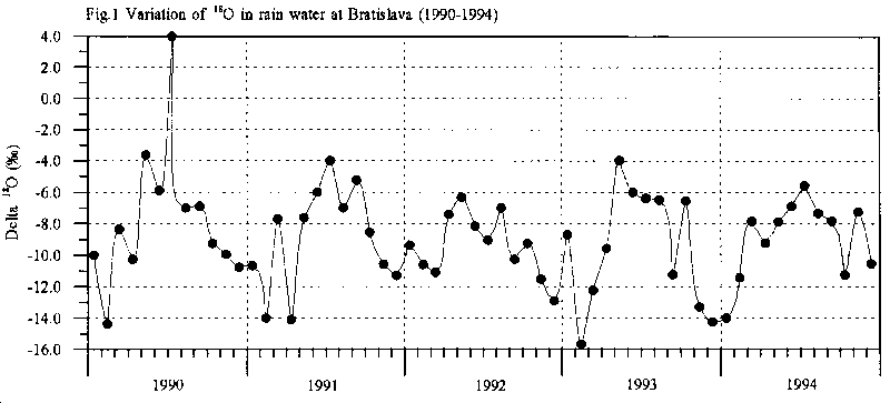
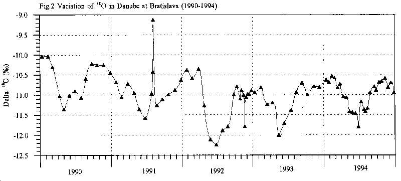
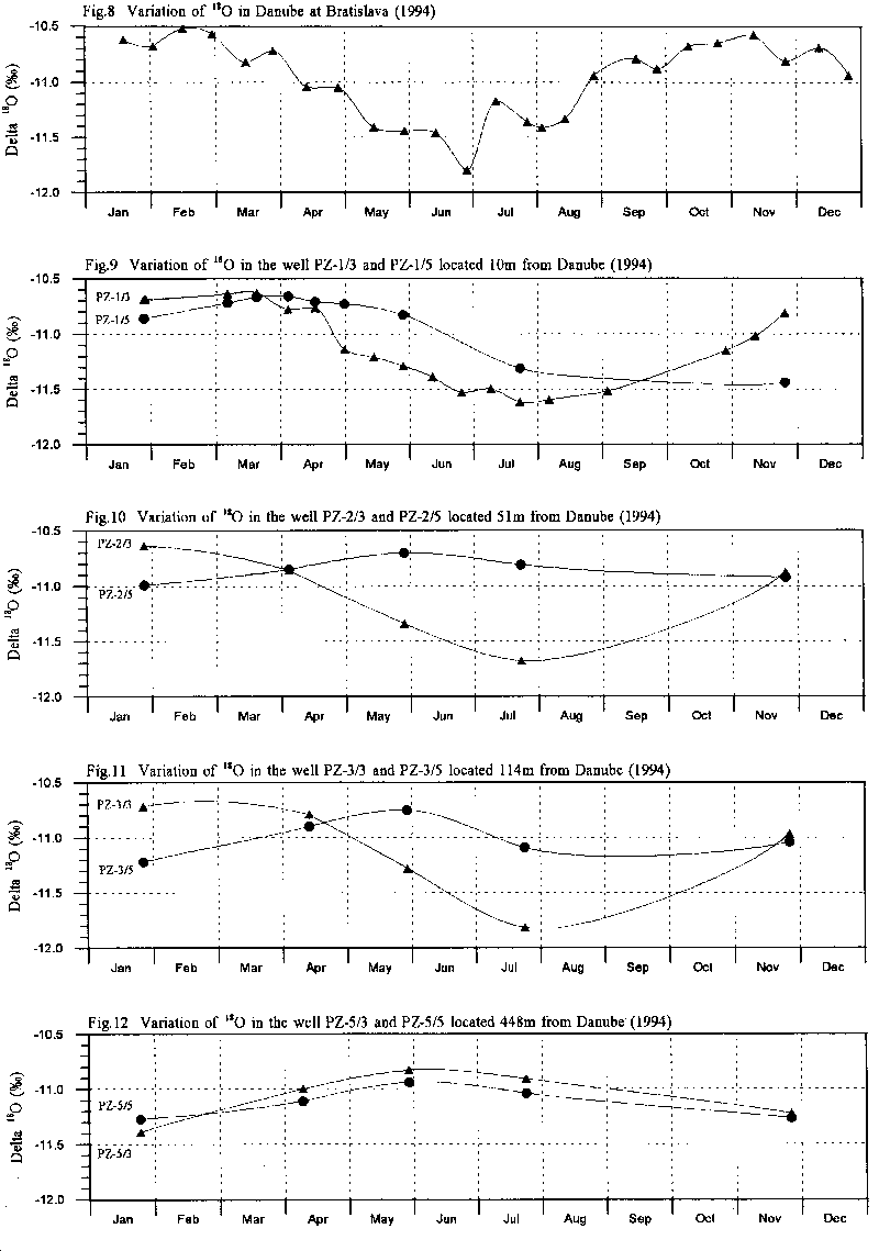
The use of 18O as a tracer is based on the natural occurrence of seasonal variations in the rain- and river water concentrations. The seasonal variations in d18O in the local precipitation (Fig. 1) follows to a great extent, but opposite in amplitude, the variations in the Danube (Fig. 2). Due to the different conditions of recharge areas (climatic, orographic etc.) the Danubian water shows a specific behaviour; the ratio of stable oxygen isotopes is different from surface flows in the lowland area. The Danube river is characterised by minimum d18O-values usually in June, which can be attributed to snow melt water from the Alps [11].
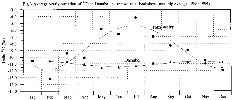
Fig. 3 shows the average seasonal variations in the Danube and in the rainwater at Bratislava (monthly average, 1990-1994). The presented time series show the average concentration levels for incoming river water and rain water. Hence, these natural changes are reflected in the 18O concentrations in the groundwater, enabling the tracing of infiltrated water within the aquifer.
A field investigation program comprising water sampling and analyses of stable oxygen isotopes has been carried out near Kalinkovo. The eleven multi-level wells of the Kalinkovo hydrogeochemical cross-section were sampled in 1994. This data set consists of ground water samples and water samples from the Danube river [10].
There are, in principle, two different water types entering the Kalinkovo cross-section:
The observations of stable oxygen isotopes in the vicinity of the Danube allow for an estimation of the basic transport parameters in the saturated zone. The change in 18O concentration is exclusively due to transport and dispersion. All impacts of solid-solute interactions, various chemical reactions and decay phenomena upon hydrodynamic dispersion may be ignored.
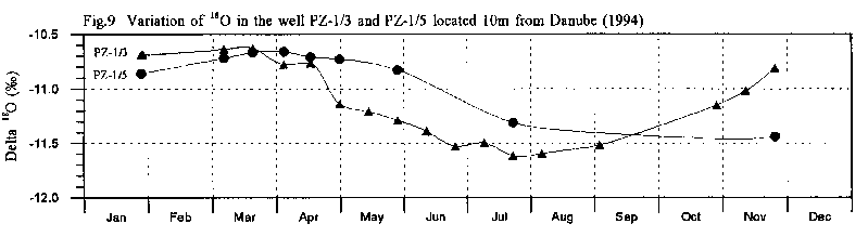
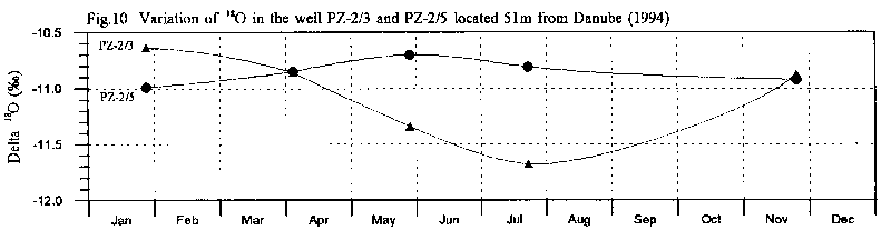
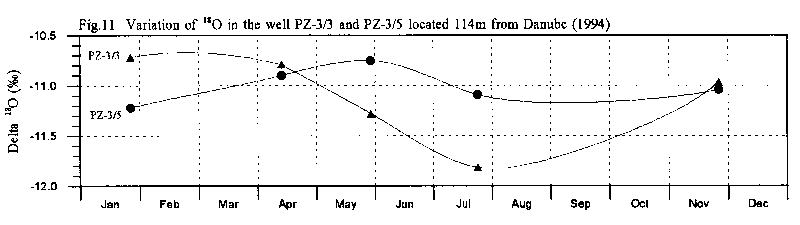
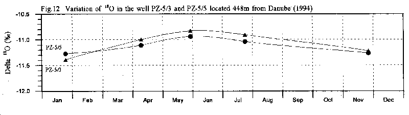
Fig. 9, 10, 11 and 12 show the d18O breakthrough-curves in the wells located at different depths and distances from the Danube. It takes, for instance, approximately 6 months for the moving front originating from the peak value in June-July 1994 in the Danube (Fig. 8) to arrive at well PZ-5. The evaluation of d 18O breakthrough-curves (their shape and arrival times) forms the basis for the mathematical treatment of the transport processes.
The transport parameters can often be calculated using simple formulas. Due to the complicated boundary conditions in the area the application of modelling methods improves the interpretation process significantly.
The movement of solutes is strongly dependent on the amount of river water entering the aquifer, the hydraulic conductivity and the porosity of the aquifer. The velocity field in the surrounding river area depends significantly on the configuration of the river bed and seepage canal, and the fluctuation of the water level in the Danube, etc. Also important is the fact, that the maximum discharge in the Danube occurs in the same period as the peak of d18O values in the river water.
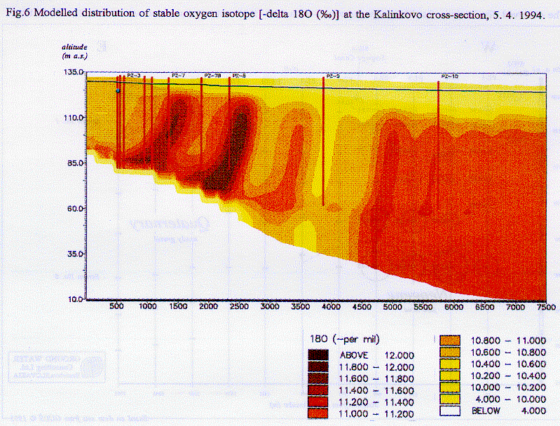
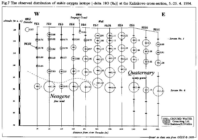
The modelling is able to take into account most of the above mentioned conditions and factors. The flow field between the Danube and the observation wells could be defined in detail. The application of modelling allows for the study and calculation of flow and transport parameters (permeability, porosity, dispersivity). The cross-sectional transport modelling of d18O was performed within the PHARE/EC/WAT/1 (MoESR, CEC, 1995) project [8]. Fig. 6 illustrates the capability of the preliminary transport model. It shows the modelled distribution of d18O at the Kalinkovo cross-section on the 4th of April 1994. We can state that the simulated distribution of d18O (Fig. 6) allows for a much better understanding of real observations (Fig. 7). Thus, it also creates the frame for further planning and interpretation of measurements.
The selection or location of monitoring wells should be planned according to the distance from the Danube and the flow velocity. It is recommended to perform the observations at several different distances from the river. It is preferable, if the screens of the wells can be located more or less along one flow(line. The frequency of the ground water sampling should correspond to the annual fluctuation of the 18O in the Danube. It is recommended to measure the Danube at least once per month. In the period April-June, when concentration peaks in the Danube river water usually occur, the measurements should be done at least on a 2-week basis [9].
It is not possible to identify the moving front in the aquifer, if it is older than 2-3 years (Fig. 6, 7). Experience from field investigations show that significant fluctuations of d18O values in the groundwater can be measured within a distance of 4 km from the Danube (Fig. 8, 9, 10, 11, 12). Over a longer distance the annual fluctuation disappears due to hydrodynamic dispersion.