CHANGES IN THE GROUND WATER REGIME AT THE RIGHT SIDE
OF THE DANUBE AFTER SETTING UP GABCIKOVO HYDROPOWER STRUCTURES INTO OPERATION
Dalibor RODAK - Lubomir BANSKY
GROUND WATER Consulting Ltd., P.O.B. 6, 840 00 Bratislava 4, SLOVAKIA
CONCLUSIONS A differentiated decrease of the ground water level occurred at the right-hand side of the Danube, during the long-lasting low water levels in the Danube before damming. The ground water flow from the direction of the inland agglomeration of Petrzalka and Austrian territory enabled the transport of contaminants towards the wells of Waterworks Rusovce - Ostrovne lucky - Mokrad. The raise of the water level in the Cunovo Reservoir have constituted a radical change in the ground water level and flow. At the right hand side of the Danube the ground water level in the area of the water works has increased by approximately 2 - 4 m. The increase of ground water level have had a positive impact on the discharge of the waterworks wells. At present, the direction of the ground water flow is prevailing from the Danube towards the water supply well field at Rusovce, and further on towards inland. Since the total dissolved solids of the ground water were originally very high, even up to 1000 mg/l at some localities, decrease of them is regarded as dominant and positive change in the area. The content of chlorides and sulphates, and total dissolved solids rapidly decreases at the wells, which were directly affected by the water from urbanised territory before damming. The water level raise in the Danube had not caused any extraordinary changes in wells, concerning microbiological parameters. Concentrations of all metal microelements is far under the standard limits for drinking water. Thereby, a very positive change from the point of ground water quality, linked with the increase of the proportion of the water infiltrated from the Danube, has been observed. New conditions constitute, from both, quantitative and qualitative points of view, an unambiguous profit.
CHARACTERISTIC OF TERRITORY AT THE RIGHT SIDE OF THE DANUBE.
The importance of the territory on the right-hand side of the Danube for the ground water resources follows from the existence of the high capacity waterworks Rusovce - Ostrovne lucky - Mokrad, and the local waterworks for the villages Rusovce and Cunovo (see map in [5], in this issue).
The waterworks Rusovce - Ostrovne lucky - Mokrad (WS ROM) is located between the Danube and Rusovce and Cunovo villages, parallel to Cunovo reservoir. The water works utilises ground water recharged by the water infiltration from the Danube. The system consists of 23 wells situated in a distance of about 120 m from the seepage canal, and 500 - 600 m from the Danube, at present reservoir. The distance between the individual wells is 100 m. The capacity of the locality Rusovce - Ostrovne lucky ranges between 800 and 1200 l/s. The total capacity of the whole waterworks after setting the hydroelectric power structures Gabcikovo into operation, together with the newly built wells in locality Mokrad, equals 2480 l/s [1].
From the geological point of view the territory of waterworks consists of the Danube Quaternary high permeable gravel-sand sediments. Their thickness in the upper part of the area (Rusovce - Ostrovne lucky) is 50 - 60 m, and in the lower part of the area (Mokrad) 60 - 80 m.
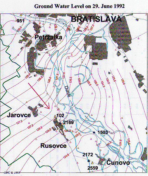
Before damming the Danube locally differentiated decrease of the ground water level occurred. The territory was partially drained by the Danube itself and by pumping of the water from the water wells. This was accompanied by a lasting decrease of the ground water level, and with the large extending of the cone of depression with negative accompanying side effects [1]. Another long-term influence, the forwarding process of the river bed erosion downstream Bratislava, had a negative impact on the decrease of the ground water level, and it caused a decrease of the amount of infiltrated water from the Danube [3]. Under these conditions the ground water flow direction enabled the transport of contaminants from Petrzalka city and the Austrian territory towards the water supply wells. From the waterworks standpoint also the shift of the ground water watershed towards inland, as far as the Cunovo village, was regarded as negative [1].
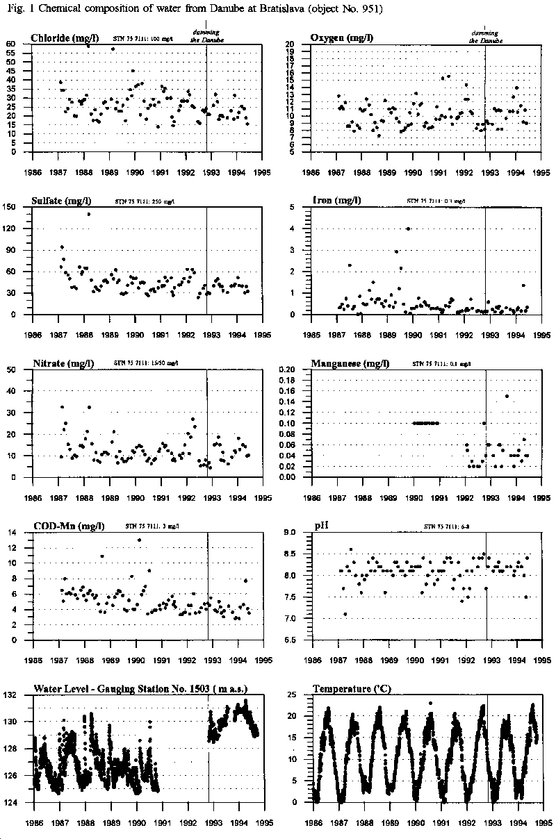
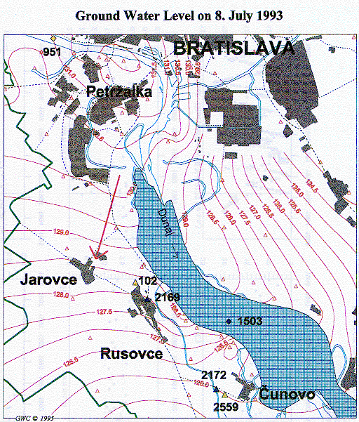
The increase of the water level in the Cunovo reservoir (Fig. 1, gauging station No. 1503) caused a radical change in the ground water level and ground water flow (Fig. 4a,b ). At present prevails the ground water flow from the Danube towards the system of wells of the Waterworks Rusovce - Ostrovne lucky - Mokrad, and further towards inland. The increase of the Danube water level by 2-4 m resulted in the increase of the ground water level by about 2 m at monitoring object No. 2169, at Rusovce (Fig. 2), and also at object No. 2172, at Cunovo (Fig. 3). In the territory of the water works an increase of the water levels by about 3.5 m was observed [2].
The ground water level oscillates at a level close to the surface, after damming the Danube. In the area in all terrain depressions and old Danube river arms, the ground water appeared. Similarly, Chorvatske rameno arm in the Petrzalka suburb has been filled again by the ground water. Water sluices in the seepage canal can regulate the water level and thus the ground water level of the adjacent area to an optimal depth.
Monitoring of the hydrochemical and water level regime of the ground water on the right-hand side of Danube is carried out by the Bratislava Waterworks and Sewerage (VaK) company and the Slovak Hydrometeorological Institute (SHMU). VaK ensures regular monitoring of the ground water quality, not only at wells utilised for drinking water supply, but also at observation wells in the surroundings. For the evaluation of the development of the ground water quality at locally exploited wells in Rusovce and Cunovo villages, data recorded by VaK were used. For the characterisation of ground water quality development in the area we made use of multiple-screen piezometers. The reason for the choice of these is mainly the modification of water chemistry in exploited wells in the waterworks by the in-situ treatment technology VYREDOX.
GROUND WATER QUALITY
Development of the ground water quality at the right side of the Danube is variable. Its diversity is given first of all by the two basic impacts, especially by the recharge of the Danube river water and by anthropogenic factors - namely the impact of the building sites of Petrzalka suburb, waste(dumps, and industry. These impacts are manifested in time and space by great changes in the concentration of such components as chlorides (15 - 50 mg/l), sulphates (30 - 250 mg/l), dissolved solids (300 - 1,000 mg/l), and nitrates (up to 40 mg/l).
The ground water quality is lowered mainly due to the increased concentration of soluble forms of manganese (up to 0.82 mg/l), and low saturation by oxygen [1]. The in-situ technology directly in the aquifer is used (a method named VYREDOX) for treatment of manganese.
Oxidation-reduction processes affect mobility, toxicity, etc., of several substances. Chiefly, oxygen, organic carbon, and nitrates take part in these processes in the area [3]. Investigation of the concentrations of such substances in ground water points to the fact that after the establishment of new conditions in the ground water flow and level a new, more suitable, Danube related equilibrium relations have been arisen in the aquifer.
A steeper hydraulic gradient causes, e.g., more intensive infiltration of Danube water, with high concentration of dissolved oxygen, to the aquifer. On the contrary, an oscillation of the ground water level in the upper soil horizon with a higher concentration of natural organic matter causes the decrease of content of dissolved oxygen and nitrates. However, the water level depends also on the exploitation of the water wells, the water level drawdown in wells, and the shape of the cone of depression. The increase of the ground water level has a positive impact on the capacity of the wells.
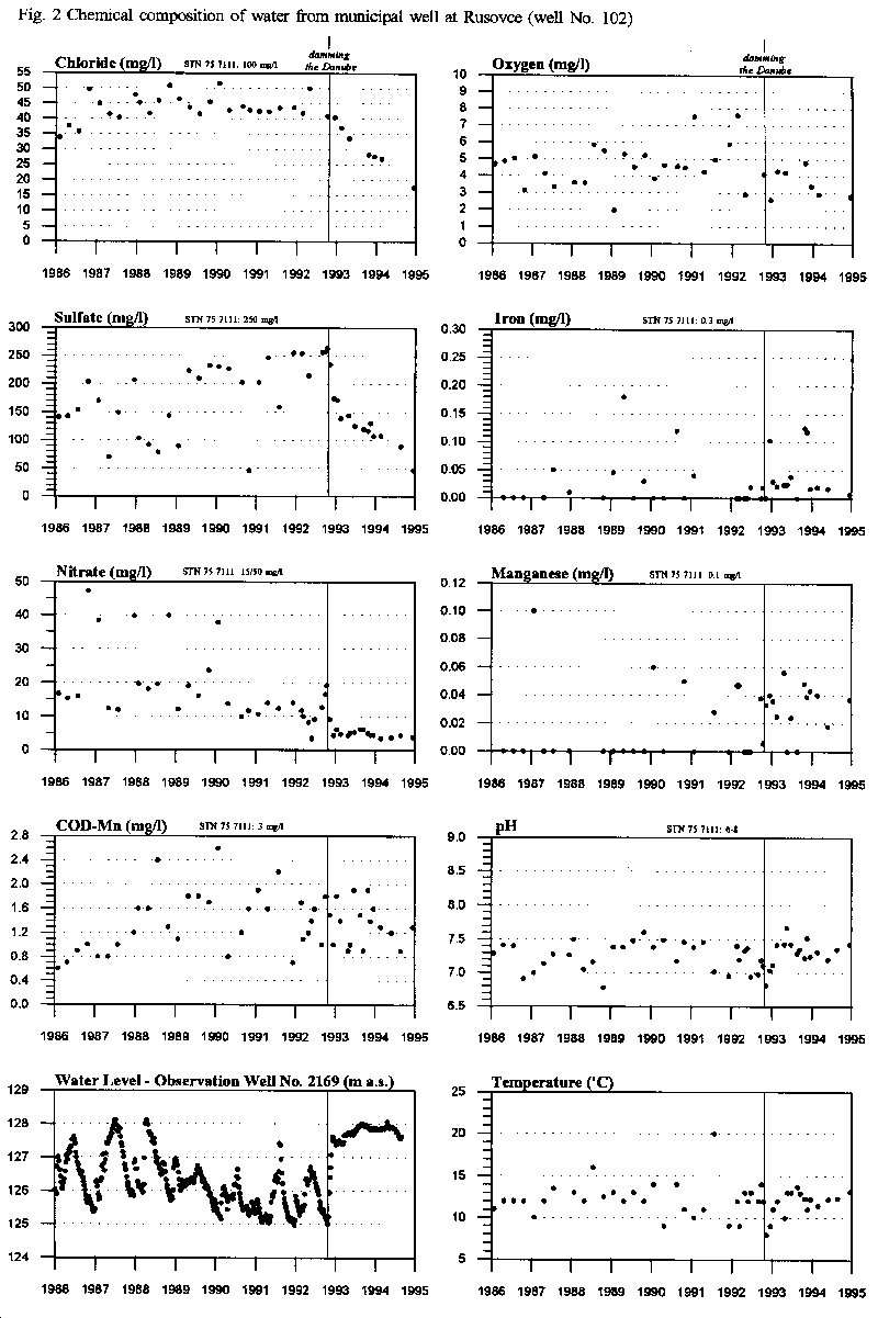
For the graphical presentation of changes of the ground water quality after putting the Gabcikovo hydropower structures into operation, the exploited well No. 102 in Rusovce has been chosen (Fig. 2,4). The well filter is situated in the depth of 15 - 22 m under the surface. This well properly represents the development of chemistry in large surroundings, as it has been continuously pumped for a long time period. Both, hygienic protection of the well and the method of sampling and chemical analysis have been performed according to standard methods used by the waterworks. An important fact is also that in contrast to all wells used for the water supply, chemical parameters of this well are not affected by the in-situ treatment VYREDOX. Therefore, it may be declared that the data are of high quality for the interpretation of chemical composition of ground water.
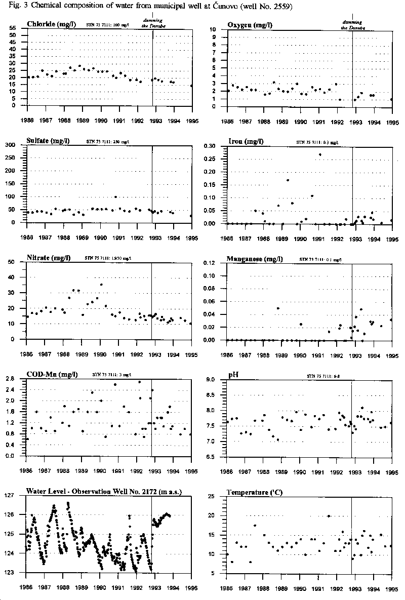
There were large differences in the quality of the water taken from individual wells on the right-hand side of the Danube, in pre(dam conditions. This differences have now gradually a decreasing tendency. The contents of chlorides, sulphates, and total dissolved components in the wells, which were at the pre-dam conditions directly influenced by the ground water flowing from inland, have rapidly and significantly decreased. Changes in oxygen and nitrates content are linked with the water infiltration from the Danube. The development of chemical composition is documented by the long-term time plots of concentrations of selected parameters in exploited wells in Rusovce (Fig. 2) and in Cunovo villages (Fig. 3). The quality of the Danube water is represented by water samples taken from the Danube at Kalinkovo (Fig. 1).
Changes in ground water quality after damming the Danube are briefly following [4]:
- Since the ground water at the right-hand side of the Danube had a high contents of total dissolved solids, up to 1000 mg/l at some places, a decrease of this contents is regarded as dominant and very positive change in the area from the point of the ground water quality. This decrease is caused mainly by the decrease of concentration of sulphates and chlorides. The content of chlorides and sulphates at some objects (Fig. 2) has decreased down to values close to that of the Danube water (Fig. 1).
- The occurrence of sulphates in the ground water was often at the limit of the drinking water standard (250 mg/l). The increased infiltration of the Danube water after damming causes a replacement of the ground water influenced by the suburb urban activities, by the river Danube water. Water with a low content of sulphates substitutes the ground water with higher content at places, where the increase of the Danube water level has changed the ground water flow direction and higher infiltration of the water from the Danube occurred.
- Chlorides, as conservative tracer, represent an indicator of an eventual contamination of the ground water from the surface, e.g. from communications. In some cases the increased content of chlorides could be caused by a seldom and abnormal increase of the content of Cl in the Danube water, up to 60 mg/l (Fig. 1). The ground water infiltrated from the Danube should have chlorides content of about 20 mg/l. The original concentration of chlorides in the ground water is higher than that in the surface water, mainly due to the anthropogenic pollution from the Petrzalka agglomeration. Therefore, a significant decrease of the content of chlorides as a consequence of the filling the reservoir is visible, particularly downstream Petrzalka (Fig. 2), where the direction of the ground water flow has substantially changed. It may be stated that after setting the water engineering structures into operation the content of chlorides in the wells near the reservoir has been decreased.
- The parameter COD(Mn) characterises the content of organic substances, which act as reductants (donors of electrons) in the oxidation-reduction processes in the ground water. Its values vary mostly in the interval below 3 mg/l, which correlates with the state before the damming. For the territory on the right-hand side of the Danube it holds that the given values express also the content of some other substances, as far as they can be oxidised by the oxidation agent used. For example, the content of the bivalent Fe interfere too. The values of total organic carbon TOC vary up to 2 mg/l.
- The right-hand side of the Danube was distinctive by high concentrations of iron and manganese in the ground water exceeding standard limits already in the past, before damming the Danube. In some observation wells, as a consequence of the inflow of ground water originated from the Danube water, besides chlorides and nitrates, also concentrations of iron and manganese decreased. At other objects these concentrations comply with standards. In future, the contents of iron and manganese will probably fix to values complied with standards.
- Initially, the increase of the water level in the Danube favourably increased oxygen content in aquifer (observation objects in the area of Water Supply Rusovce - Ostrovne lucky - Mokrad), in which direct transport from the river and dispersion-diffusion penetration on the boundary between saturated and non-saturated zone took part. Oxygen transport into aquifer follows sinusoidal course, which correlates with seasonal changes of water temperature in the Danube. After initial increase of oxygen concentration its decrease occurred again (probably also due to decrease of water level in the reservoir in the course of 1993-1994). Oxygen transport into ground water caused by raise of water level, however, is henceforward manifested by slow continual increase of redox potential which leads to reparation of anoxic to oxic conditions. This is a long-term process [1].
- During the decrease of oxygen concentration in ground water a reduction of nitrates occurred, as a following acceptor of electrons at oxidation-reduction processes. These processes could lead to, e.g., increase of the concentration of ammonium ions, reduced forms of nitrogen. Occurrence of individual forms of nitrogen correlates with the oxygen regime in the Danube. Values of parameters which describe content of individual forms of nitrogen mostly comply with standards for drinking water. Standard limits are in some places exceeded only by ammonium ions. Nitrates concentrations in the wells of Rusovce and Cunovo villages and in the Danube are enclosed (Figs. 1, 2, 3). Content of nitrates in the well at Cunovo corresponds approximately with that in the Danube river. In the well at Rusovce it has decreased down to the half of previously recorded level. Ground water from this locality is now of high quality and well suited for drinking purposes.
Sampling, treatment, and interpretation of data on the ground water quality at multiple piezometers in surrounding of the well field of the water works Rusovce - Ostrovne lucky - Mokrad is carried out by the HYDROsampling company. Results of long-term monitoring of the ground water quality have revealed the following [1]:
- Values of group parameters TOC, COD(Mn), and Non(polar extractable species for the time period after filling the reservoir reveal neither frontal transport of organic substances towards the well fields of the water supply nor deterioration of the ground water quality. In the course of the followed time interval at the territory no negative changes have occurred in the water quality due to migration and transport of specific organic matter from the Danube. Concentrations found during previous stages of investigation were occasional and residual from previous hydraulic state and from the flow from the urbanised territory.
- Concentrations of all metal microelements are far under standard limits for drinking water. Periodicity of their concentrations depends on their fluctuation in the infiltrated Danube water and is influenced by processes of adsorption and release due to changes of physical and chemical parameters.
- From the point of microbiology, increase of water level in the Danube have not caused any extraordinary events in the well field and in the water work area.
Increase of water level in Cunovo reservoir did not caused significant changes in the ground water quality in the area at village Cunovo, (local exploited well No. 2559, Fig. 3.) and this despite of 2 m increase of ground water level (measured e.g. at well No. 2172, Fig. 3.). This is because of the fact, that both, for pre-dam and reservoir conditions, the ground water flow direction have been nearly the same, and this from the Danube towards the well and farther toward the hinterland.
REFERENCES
- [1] Hauskrecht, I., Polcan, I., 1995: Evaluation of Hydro-Chemical Ground Water Regime at the Territory Between Water Works Rusovce - Ostrovne lucky - Mokrad and Cunovo-Hrusov Reservoir after Damming the Danube. ("B/5"). Final Report. HYDROsampling Bratislava, February 1995.
- [2] Pospisil, P., Kucera, K., 1992: Evaluation of Ground Water Regime in the Water Works Rusovce - Ostrovne lucky - Mokrad and Broader Surroundings, October - December 1992. Final Report. Ekokonzult-Pospisil, December 1992.
- [3] Mucha, I., Paulikova, E., Hlavaty, Z., Rodak, D., Zelina, I., 1992: Optimisation of the Finishing of Hydroelectric power structures Gabcikovo on the CSFR Territory from the Impact on Ground Water Standpoint. Ground Water Consulting, Faculty of Natural Sciences, Bratislava, 1992.
- [4] Mucha, I., Rodak, D., Bansky, L., et al., 1994: Evaluation of Results of Monitoring of Environment on the Territory Affected by Hydroelectric power structures Gabcikovo according to the Decision of OUZP Bratislava-vidiek, No. Vod. 449/Am-39/1993-W. Surface and Ground Water. Final Report. Ground Water Consulting Ltd., Bratislava
- [5] Rodak, D., Mucha, I., 1995: Current Activities in the Ground Water Quality Monitoring, Construction of Monitoring Wells, Methods of Sampling, In-Situ Measurements. This issue.