CONCLUSIONS Long(term changes in ground water levels during the last 30 years and changes caused by the construction and operation of Gabcikovo hydro(power structures are represented on maps. The area of direct impact of hydro(power structures on ground water is defined. Ground water levels have increased after damming the Danube and recovered to nearly the stay which was known in 1960's.
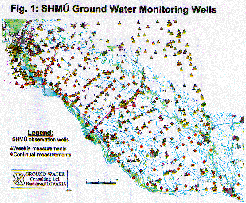
The network of observation wells was established and measured by the Slovak Hydrometeorological Institute (SHMU). Weekly measurement is carried out manually, or continuously using limnigraphs or other automatic recorders. The location of SHMU observation wells is documented on map in Fig. 1. This map also documents the density of observation points in the area of interest.
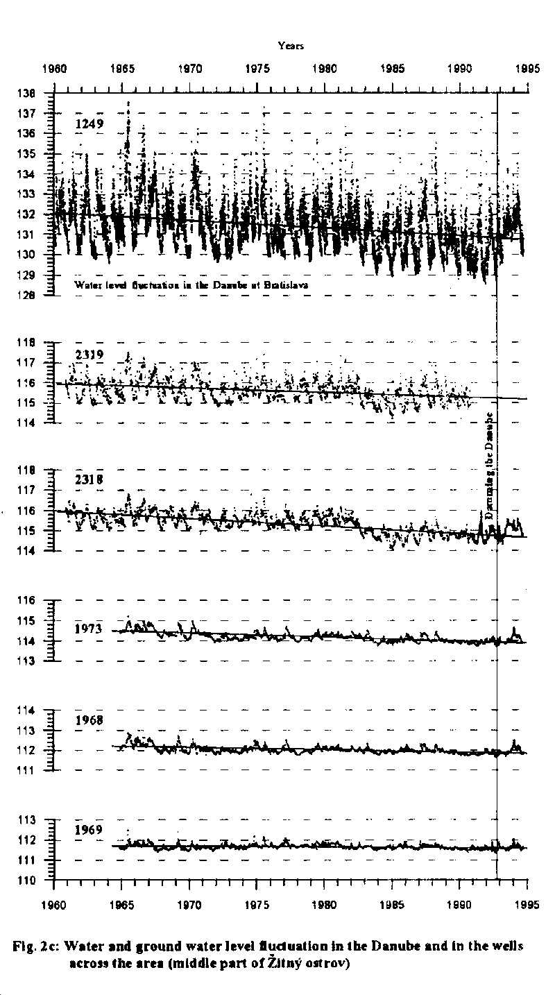
The canal network, agricultural drainage facilities and melioration have a stabilising effect on the ground water level changes and fluctuation. A long(term decrease of the ground water level on the both Danube sides is evident over a large part of the territory. Such development is also visible at wells chosen in the middle part of the area in the profile at the town Dunajska Streda, Fig 2c.
These changes in ground water levels were at various places, of various origin. While some were caused by river bed sinking, others resulted from water pumping at hydraulic blanket at the Slovnaft refinery, urbanisation of Petrzalka, works at Gabcikovo, works in connection with construction of the Nagymaros part of hydropower project, agricultural melioration, changes in irrigation and drainage canal systems, and irrigation patterns, exploitation of ground water for municipal water supply, etc. This decrease of ground water level in the largest part of the area was irreversible and for a long time had already negatively influenced the natural conditions, mainly agriculture, forestry and ground water resources.
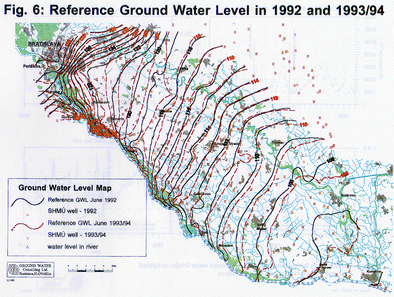
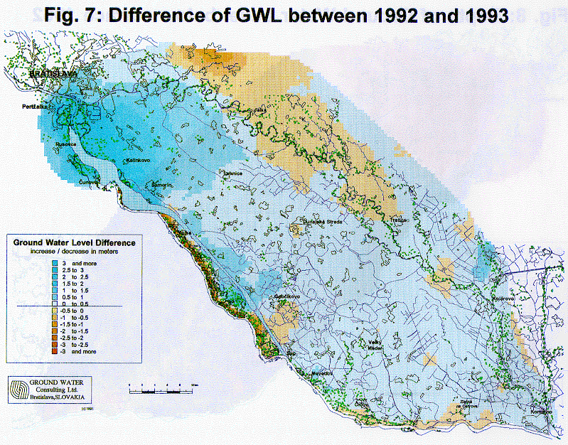
To illustrate the general situation in ground water levels, map of average ground water level for interval from July 1993 to July 1994 have been plotted together with reference water level contours characterising the pre-dam conditions in 1992, Fig 6. Differences of these ground water levels, shown in Fig. 7, represent the impact of putting the Gabcikovo part of the project into operation. The major impact is the general increase of ground water levels in the upper part of the Zitny ostrov island area as well as on the right side of the Danube in the Slovak territory. Another limited impact is the decrease of the ground water level close to the Gabcikovo tail-race canal. A decrease of the ground water level is also seen in the area close to the Danube of the floodplain area, which is a result of the drainage effect of the old riverbed. A decrease in the northern part of the area is due to the dry years 1992, 1993 and 1994.
Measured changes in the ground water level in the main part of the floodplain area and in the whole Danubian Lowland region confirm the positive impact on the upper part of the area and an important positive role of the water supply for the Danube left side floodplain. It confirms that after completion of the water supply of the floodplain area close to the Gabcikovo tail-race canal and the small area at Dobrohost between the by-pass canal and the Danube, there will also be an positive change of previous development. Shallow underwater weirs in the old river bed of the Danube could also improve the situation along the Danube in the floodplain. In general, measured ground water levels have recovered to state, similar to those known 20 - 30 years ago, at the respective part of the territory. At the downstream confluence of the tailrace canal and the old Danube, no significant changes were measured.
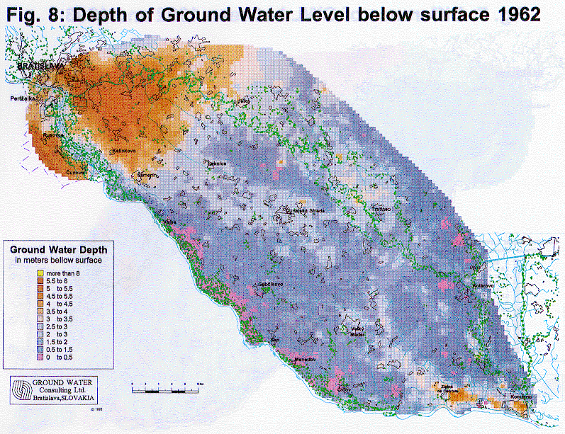
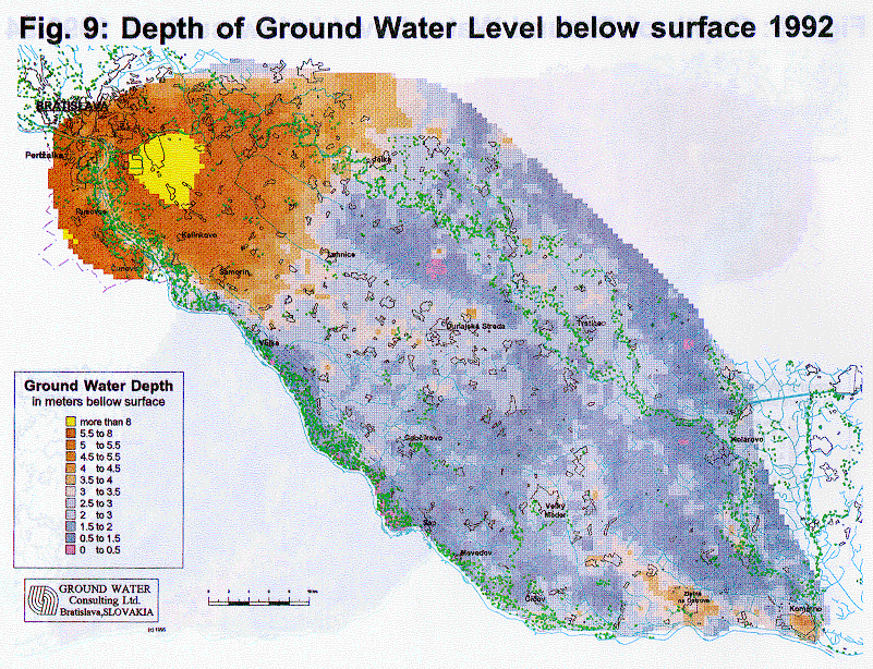
Using a surface elevation map and ground water level maps for 1962, 1992, 1993/94 years, maps reflecting depths of ground water levels were constructed, Fig. 8, 9, 10. From the maps the areas with depths of ground water levels less than 0.5 m (areas with soil water logging possibilities) could be recognised. Another extreme situation is at places where the depth to ground water level is larger than 8 m. It can be seen, that the depth to ground water level is only exceptionally less than 0.5 m and this occurs only at the floodplain area where it is wanted and at the lower part of area of the Zitny ostrov island, which is not directly influenced by the Gabcikovo hydropower system of constructions.
In comparing the three maps, there is no doubt, that the ground water level have increased after damming the Danube and supplying the river branch system with water, to nearly the states which were known in the 1960's. This improved situation in comparison with pre-dam conditions is mainly near the reservoir downwards Bratislava and Petrzalka and generally in the upper part of the area.
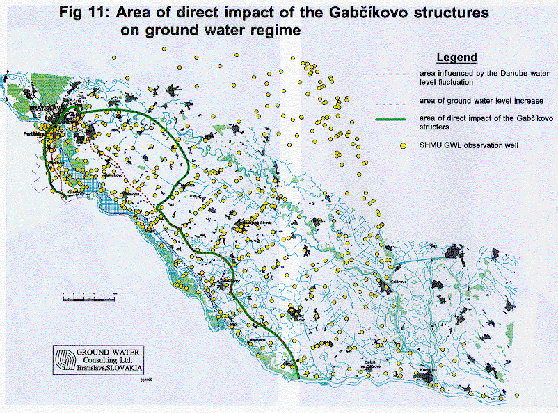
The map defining the direct visible impact of the Gabcikovo part of the hydropower structures on the ground water level is based on previous maps and an interpretation of ground water level fluctuation was constructed and is presented in Fig. 11. In general this direct effect is positive and can be optimised by various technical means, e.g. mainly with shallow underwater weirs in the old Danube at some places, regulation of seepage canals, water supply and flooding the inundation area, etc.