CONCLUSIONS In the major part of the left side river branch system, fed through the intake structure at Dobrohost, relatively high water level conditions are kept during the whole vegetation period. The flow in the upstream part (upstream line D) is comparable with the pre(dam stages for 4000 m3s-1 in Bratislava and between lines E to D with the pre dam 3000 m3s-1. The very downstream part of the system is controlled by the water level fluctuation in the Danube. The water level in the old Danube could be increased substantially by constructing a series of submerged hydraulic structures. An increase in water level of more than 1.5 m was achieved by the discharge of 400 m3s-1 in the old Danube using preliminary design of structures situated in the reach between rkm 1817-1825. The guaranteed width of 90 m and depth of 2 m in the old Danube could be achieved at discharge rates of 1500 m3s-1 or higher. The flow velocity is about 0.5 m.s-1 in the reaches between the structures at discharge 400 m3s-1 and about 1 m.s-1 at discharge of 1500 m3s-1 .
River training works, which have been carried out on the Danube since the early 18th Century, have reduced the natural river development processes to a several kilometers wide strip along the river. Flood protection and navigation were the main reasons for the river regulation.
The construction of hydroelectric power structures in the Austrian reach of the Danube as well as dredging and regulation for navigation, led to a reduction of water levels. As a result, a partial disconnection between the side arms and the main river occurred during the low flow periods.
Recently, the Danube has been affected by the construction and operation of the Gabcikovo hydro-power structures. The main flow of the river (downstream river km 1851.7) is concentrated into the by(pass canal, flows via the hydro power station and joins the main river at river km 1811 (see the layout in Fig. 1). In the old river bed between the weir Cunovo and the confluence with the hydro-power plant tail-water canal, the low flow conditions prevailed during the whole year. To prevent the river branches at the left side of the Danube from drying out, an intake structure was built at Dobrohost, which feeds the river branches with water from the by-pass canal.
The water level regime in the Danube between river km 1820 and 1840 and in the adjacent river branches system under the pre- and post-dam conditions was one of the subjects of investigation in the frame of the PHARE Project entitled "Danubian Lowland - Ground Water Model" [4, 5, 6].
The mathematical modelling approach enables comparison of the water level regime and dynamics for both the pre- and post-dam conditions and optimisation of the intake structure operation and the Danube river engineering works with the aim to save the special wetland conditions in the river branch system.
It is seen that the data for the model setup comes from various time periods. This is mainly because of the lack of data for the side arm systems for the period just before putting the structures into operation. Generally, the last available data were used to model any part of the system. It is known [6] that the river bed degradation in the investigated part of the Danube (water level changes at a discharge of 1000 m 3s-1) ranges from approximately 81 cm in river km 1840, through 22 cm in river km 1825 to 7 cm in river km 1820 for the time period from 1974 to 1990. The river bed degradation influences mainly the lower discharge water levels. The flood discharge water level width, comprising both the left and right side flood plain, is up to 5 km, thus, the additional cross section area due to the river bed degradation creates only a very small portion of the total high discharge cross section area.
It was proven during the model calibration, that the flood water level regime has not changed significantly during the last two decades. Thus, the presented model represents the specific pre(dam conditions (1988-1992) in terms of water level regime for discharges up to 4000 m3/s. For discharges higher than 4000 m3/s, the conditions have not been changed significantly since the late sixties and the model is suitable for representing the high discharge conditions for the whole period 1965-1992.
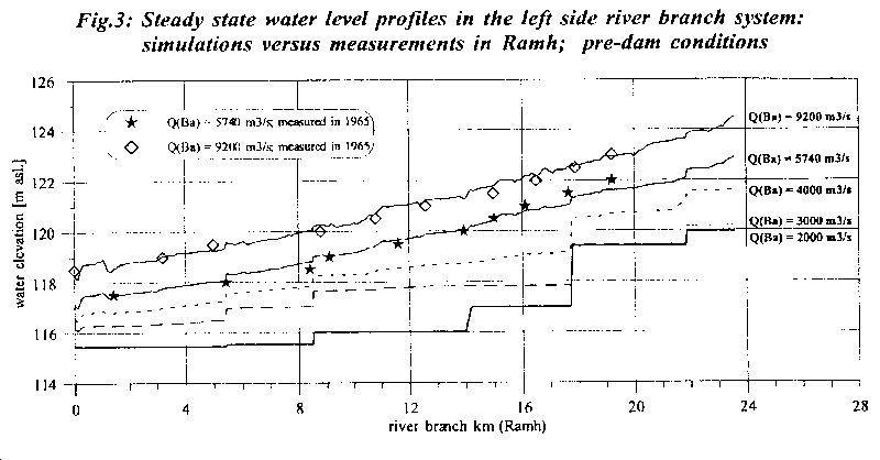
The comparison of the measured and modeled water level profile in the main river branch in the left-side flood plain, shown in Fig. 3 , is another evidence of the model reliability. There are little data to compare the low flow model results with the measurements in the flood plain, but the results for the flood events show surprisingly good agreement. The main river branch flows from Dobrohost along the left dike and joins the Danube at river km 1820.4. It is seen from the figure that the water was more or less stagnant in the river branch area for a discharge of 2000 m3/s with a static water level, controlled at that time by the existing barriers and dykes in the side arm system and by the ground water level. These conditions prevailed in the upstream part of the system (upstream Danube rkm 1830) also for a discharge of about 3000 m3/s. It is seen that at a discharge of 4000 m3/s, the upstream reach of the branch began to be interconnected with the main river. For a flood of 5740 m3/s, the full hydrodynamic water level was reached. The discharge conditions are very complicated for a flood of 9200 m3/s. There can be seen "steps" in the water level profile in the river branch system, indicating that the direction of flow is changeable.
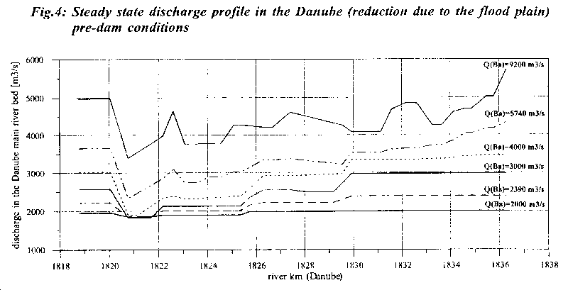
Modelling of various discharges in the region under investigation proved that important discharge distribution between the main river and both left- and right-side flood plain take place for discharges higher than 2000 m3/s. The discharge reduction at the various modelled steady state events in the longitudinal profile of the main river bed in this reach is shown in Fig. 4 in terms of discharge portion flowing in the Danube. These results correspond well to values published by Szolgay [7]. It is seen from the figure that only a very small portion of the total discharge of 2000 m3/s (not more than 8%) flew to the left and right side arms' systems respectively. However, the higher the discharge in Danube, the higher is its reduction due to the side arms flow capacity. Thus, for a flood event of 5740 m3/s, the discharge in the Danube was gradually reduced throughout this reach, up to 40% of the original value close to the mouth of the main left side branch.
The model is fully dynamic. All steady state results presented here are results of dynamic modelling until the steady state was reached. The time needed to obtain steady situation varies depending upon the boundary and initial conditions in the system.
Since from the seventies there is only a little (if we do not want to say no) data available on the water level regime and discharge dynamics and distribution in this region, the presented mathematical model is a good tool to reconstruct the pre-dam conditions in the river branches system. The frequency and duration of flooding of the particular river branches and flood plain between them can be obtained by long term hydrodynamic modelling of the flow conditions in the region and prevailing velocity profiles can be estimated.
All information mentioned above was included into the model of conditions after putting the Gabcikovo structures into the operation. The hydraulic structures in the system of branches were modelled according to the original design and checked according to field measurements, supported by the PHARE Project [2]. The tail-water canal from the hydro power station was included into the model too.
In Fig. 5 there is shown a comparison between the measured water level dynamics in particular compartments of the river branch system and the model simulation for the calibration measurements period. (As model boundaries the following items were included: discharge time series through the Cunovo weir to the Old Danube, discharge via the intake structure to the river branches, discharge through the hydropower station, and Q-h relation in Komarno.). It is seen that the model results correspond well both in magnitude and dynamics with the measured values. It was proven that the model represents in a reliable way not only water level regime or discharge balance and distribution, but the travel time through the system as well.
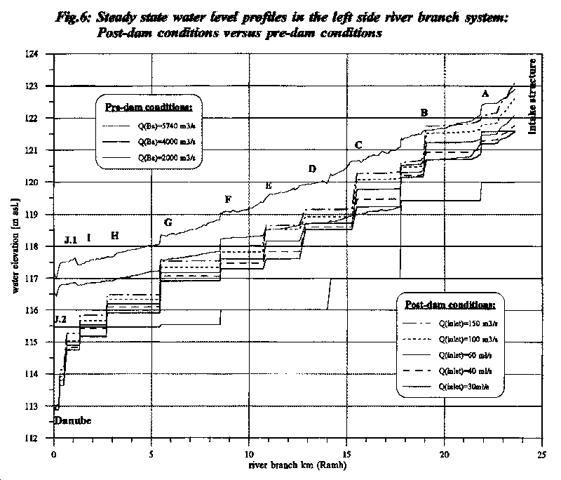
In Fig. 6 are shown longitudinal profiles of water level in Ramh (the main river branch flowing from Dobrohost along the left dike and joining the Danube at rkm 1820.4) for various discharge events under pre-dam and present conditions. The discharge through the Cunovo weir was supposed to be 300 m3s-1. The capital letters in Fig. 6 indicate the hydraulic structure lines across the river branch system. The inlet discharge into the river branch system for the dam-conditions ranges from 30 m 3s-1 (which was an often occurring inlet discharge during summer 1994) to 150 m3s-1 (which is a rather high inlet discharge and had not been reached until March 1995). Comparison is made to three pre-dam condition steady state events, ranging from mean Danube discharge (2000 m3s-1), to flood discharge (5740 m3s-1), by which full interconnection between the river and its branches was reached.
It is seen from the figure that the present water level conditions in the river branch system can be, in different parts of the system, compared to different pre-dam stages. The water level is presently higher than it was originally under the 2000 m3s-1 discharge conditions, and this in a large portion of the left side river branch system (upstream line H, i.e. cca 80 % of the total area). In the reach upstream line D, the water level reaches the pre dam 4000 m3s-1 watert level elevation under the relative low inlet discharge conditions of 30 to 40 m3s-1. The water level elevation of the pre dam flood of 5740 m3s-1 can only be reached upstream the line B (if manipulation only with the intake structure is taken into account). In the reach between lines G to D the pre dam 4000 m3s-1 flooding of the flood plain can be reached if about 150 m3s-1 flows through the inlet structure, except for the reach between lines F to E, where the water level will be a little lower.
The water level in the downstream part of the left side flood plain is mainly controlled by the water level in the old Danube. Downstream line I, with no manipulation at the intake structure, the original 2000 m3s-1 and higher stages can be reached. This could be achieved only by increasing the water stage in the old Danube river. However, this downstream part creates only a very small portion of the left side flood plain.
In analyzing the results, it is obvious that one of the ways to increase the water level in the downstream compartments is to leave the culverts open at all upstream hydraulic structure lines (to prevent the infiltration losses), and to close the culverts at the particular downstream lines.
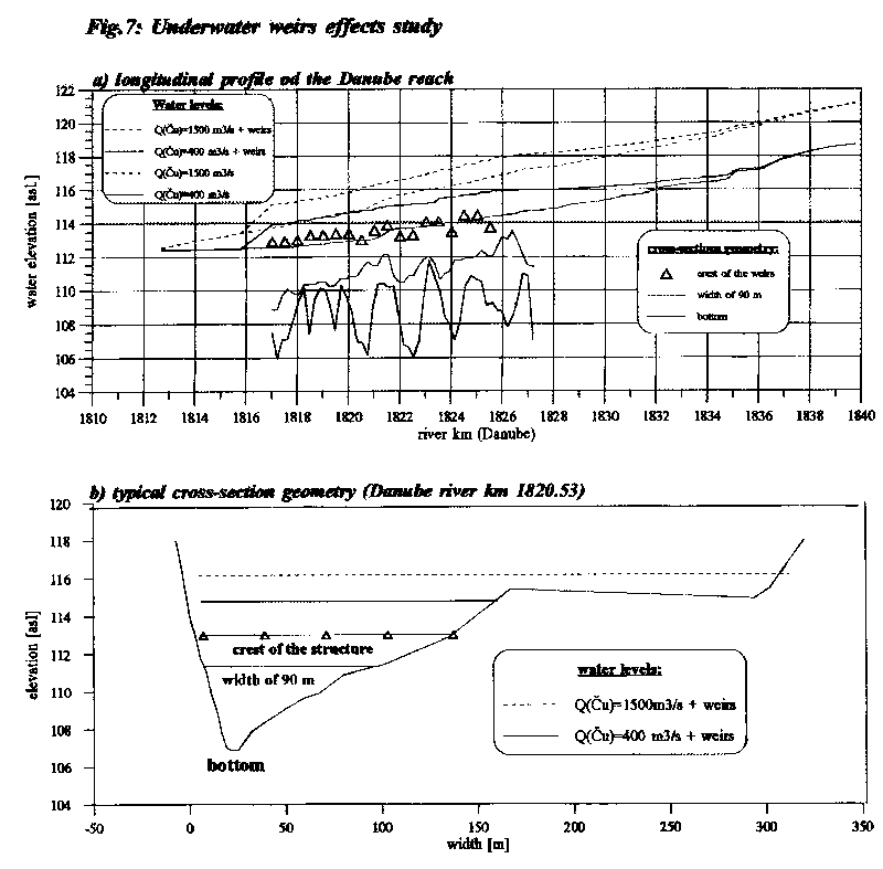
To receive an idea about the depth and width conditions both for the with- and without- under water weir conditions, the bottom line (in terms of the minimum bed elevation, black line) and the 90m width line are shown inFig. 7. The 90m width line represents the minimum elevation for each cross-section, above which the width of at least 90 m is guaranteed, i.e., the width is higher than 90 m everywhere above the green line (see also Fig. 7b). The depth and width conditions could be of great importance, if possibilities for navigation are taken into account. It is seen fromFig. 7 that for both with- and without- underwater weir conditions the minimum width of 90 m was achieved in the investigated reach of old Danube for discharges higher than or equal to 400 m3s-1. The crest width of the weirs is not smaller than 90 m either. It is also seen from Fig. 7 that the depth above all weir crests is about 2 m for the 1500 m3s-1 discharge and approximately 1 m for the 400 m3s-1 discharge conditions in the old Danube. Thus, a full water level continuity can be kept for the underwater weir conditions, which is very important not only from the navigational, but also from the environmental point of view.
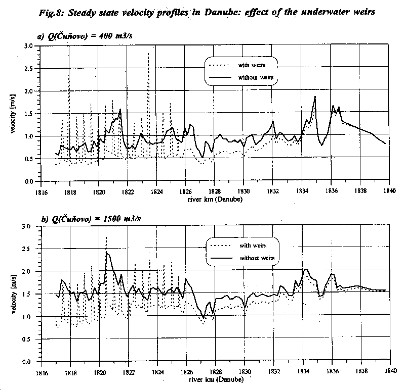
To demonstrate the influence of the weirs to the velocity in the old Danube, the comparison of the velocity profile for the conditions without- and with- underwater weirs are shown inFig. 8a and Fig. 8b for the 400 and 1500 m3s-1 discharges. It is seen that, when applying a system of submerged weirs, it is not only possible to increase the water level substantially, but also to avoid a dramatic drop of velocities (which could be expected if a system of only a few, but rather high, weirs would be put into operation). Here, only results of a study case are presented, with the aim to demonstrate the possibilities of the model to examine a number of various designs. To influence the velocity profile it is further possible to change the shape of cross-sections upstream the weirs. This could increase the lower and decrease the maximum velocities or moderate sudden changes.
Based on very detailed mathematical model results, a comparison was given between the pre-dam and present water level conditions in the left side river branch system, fed with the flow through the intake structure from the by-pass canal. It was shown that the model is very well calibrated, and thus, the results are reliable. The comparison of the pre-dam and present conditions is crucial for any environmental impact assessment in the area.
It was shown that in the major part of the left side flood plain, fed by the inlet discharge, rather high water level conditions are kept during the whole vegetation period. Only the rather small area downstream of line G is fully controlled by the reduced Danube water level profile.
To demonstrate the possibilities of spring flood simulation, a number of scenarios was run with various inlet discharge and culvert operation strategies. It was proven that, due to the rather high infiltration rates, the closure of the upstream culverts would cause a decrease in water levels in the most downstream compartments. It is reasonable to close the culverts downstream line H.
It was shown that the construction of a system of special submerged weirs across the old Danube river bed could help to substantially increase the water level not only in the river itself, but in the downstream part of the river branch system as well. In the presented scenario the fluent water level profile was achieved for both simulated discharge events. A depth of about 2m and the guaranteed width of 90 m was achieved in the investigated reach between rkm 1817 and 1825.2 for a discharge of 1500 m3s-1. The presented model also gives the possibility to evaluate the changes in the velocity profile for all examined scenarios.
It was proven that the detailed mathematical model is a good tool not only to reconstruct the existing water level regime in the region, but to optimize the structure operation as well. Flood control and flood wave transformation due to the both side flood plain effect, possibilities of the re-connection of the old river bed and the river branch system, and optimal design of the system of weirs in the old river bed are other examples of the model application.