CONCLUSIONS Large level changes of the Danube river bed have been observed in the last decades. Since 1966 the water level profile for a discharge of 1000 m3s-1 has decreased by 1 to 2 m in the river Danube downstream of Bratislava and the section close to Komarno. A 1D model MIKE 11 was used to simulate the morphological development over the period from 1974 to 1990, where dredging was also taken into account. Based on the simulation results, it was proven that the river bed degradation was mainly influenced by the river training and dredging.
Large scale level changes of the river bed of the Danube are observed even from one year to another. The river bed changes are accompanied by changes of water level of low flow. Low flow in the Danube means a discharge of about 1000 m3s-1. A single cross-section can significantly change its shape from one year to the next. Therefore it is necessary to find an appropriate way to compare the river bed changes in the whole section of the Danube river. A good possibility is to compare the water level profile of low flow for several years, which reflects the river bed level changes.
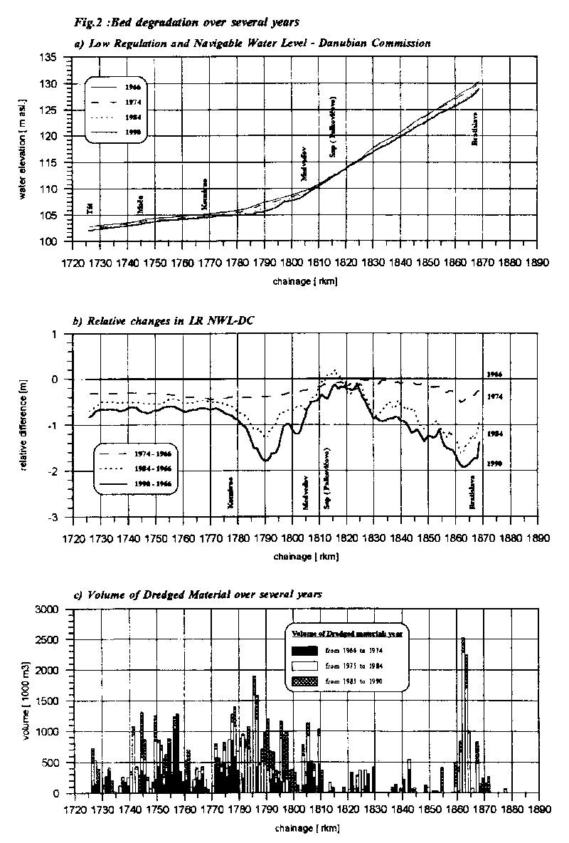
The Danubian Commission specifies the so called "Low Regulation and Navigable Water Level" (LR NWL-DC). This water level corresponds to the discharge Q94% , which is approx. 1000 m3s-1. In Fig. 2 a), there is shown the water level profile of LR NWL-DC for the following years: 1966, 1974, 1984 and 1990. The same figure also presents the relative changes in LR NWL-DC (Fig. 2 b). The reference level are the water stages in 1966. A large amount of material was dredged along the Danube river over the last 24 years (Hungarian as well as Slovakian dredging: F(ry, 1994).Fig. 2 c shows the volume of dredged material in the same river reach for the respective periods. From the figure it can be seen that during the years the water level continuously decreased. It seems that the bed degradation was mainly influenced by the volume of dredged material in the whole river section.
In order to make a morphological calibration, it was necessary to collect data of bathymetry over a number of years. The cross-sections of the Danube river surveyed in 1974 have been used to set up the model. The model covers the river reach from Devin (rkm 1880) to Komarno (rkm 1767.1). For calibration of the morphological model the period from 1974 to 1990 was used.
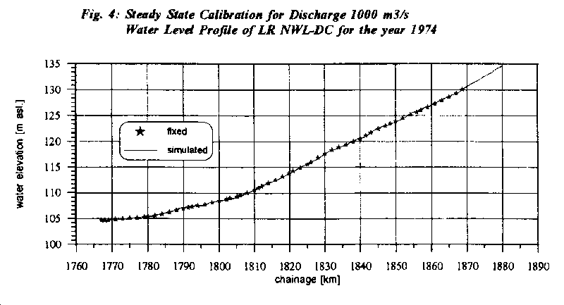
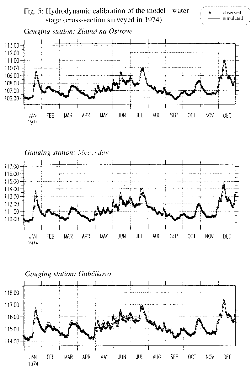
It was necessary to calibrate the hydrodynamic model using cross-sections surveyed in 1974 in order to get a good correspondence between simulated and observed water level stages in 1974. Fig. 4 shows the steady state calibration for the discharge of 1000 m3s-1. The measured water stage in a longitudinal profile (LR NWL-DC) and the simulated one correlates very well. The dynamics of the model were calibrated to water levels measured in 1974. The comparison between measured and simulated water levels is presented in Fig. 5. Results from the calibration at Zlatna na Ostrove (rkm 1779.2), Medvedov (rkm 1805.4) and Gabcikovo (rkm 1819.6) show good correspondence. The calibrated hydrodynamic model was ready for morphological simulations.
A time series of daily discharges measured in Bratislava from 1974 to 1990 were applied as upstream discharge boundary condition. This boundary is located at Devin (rkm 1880). A time series of measured water levels at Komarno (rkm 1767) creates the downstream model boundary.
The upstream sediment boundary is a time series of bed level changes. The river bed at Devin consists of hard rock, thus the river bed level change was set to zero over the whole period. Dredging in the whole river reach was also taken into account [3].
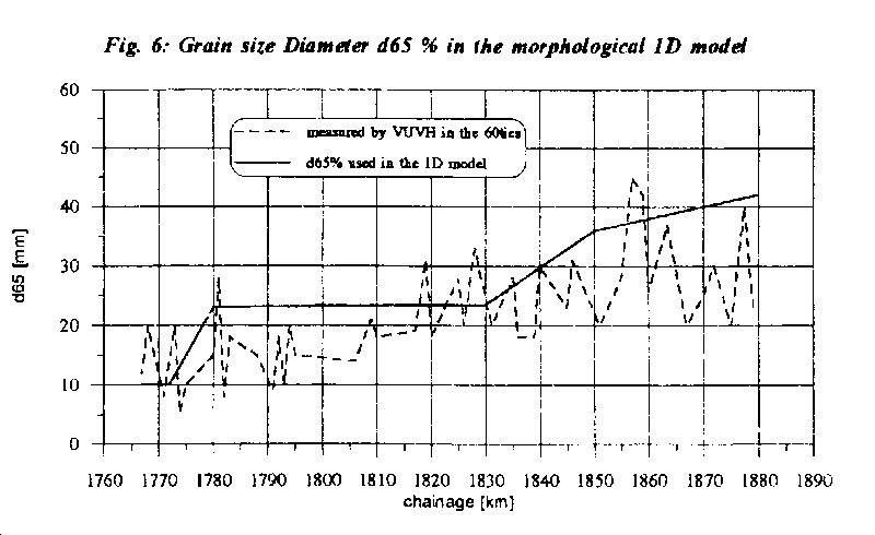
The Ackers & White formula was chosen for the computation using grain size diameter d65%. This model is appropriate for relatively coarse sediment. Fig. 6 presents the grain size diameter d65% used in the model, together with the data obtained in the 60ties.
Regarding the obtained results from the morphological model MIKE11, it can be stated that the model represents the natural conditions and the real morphological changes in the Danube river very well.
The bed level of the Danube river is very variable. The relative bed level changes are very high, up to 2 or 3 meters, during the 16-year period. Therefore the changes in the bed profile are much more scattered than the changes in the Low Regulation and Navigable Water Level. As was mentioned above the longitudinal profile of low flow gives a better view on morphological development of the Danube river.
An illustration of how sediment transport combined with dredging over several years can change the shape of a single cross-section is shown inFig. 9. This figure presents a cross-section on river km 1799.273 for the years 1974, 1979, 1991 and 1993. The minimum bed level increased by 0.8 m (deposition) over 5 years (1974-1979) and decreased by 3.2 m (erosion) over next 12 years (1979-1991) and again decreased by 2.6 m (deposition) from 1991 to 1993.
Generally, the shape of the cross-sections in the Danube river are asymmetrical and the major part of the sediment transport occurs at the flat sloping parts of the cross-sections. The deepest part of the cross-sections do not play such an important role in the sediment transport [6]. That is, why the observed and simulated changes in the bed level profile are not presented in this paper.
The dredging amounts included in the model are the amounts of material in the whole river reach, the Slovak together with the Hungarian dredging.Fig. 10 depicts the effect of the dredging for the morphological changes in the Danube river bed in the reach from Devin (rkm 1880) to Komarno (rkm 1767). The full line represents the observed LR NWL-DC from the year 1990 both in absoluteFig. 10 a) and relativeFig. 10 b) values. The dashed line exhibits model results where the dredging in the whole reach and over the simulation period was not taken into account. The dotted line represents the LR NWL-DC in 1974. The volume of dredged material is seen inFig. 10 c).
Regarding the observed relative changes in LR NWL-DC (with the dredging) a significant degradation is observed along the river reach downstream Bratislava; rkm 1869.7 - 1840, and along the reach from rkm 1805 to 1785, where the LR NWL-DC has decreased by 0.8 - 1.5 m. Only the river reach between rkm 1825 - 1810 can be described as a stable river reach. FollowingFig. 10 c) it can be seen that the greatest amount of dredging was done in the same reaches where the bed degradation occurred.
Regarding the simulation results of the morphological model without dredging, it can be stated that small erosion takes place downstream of Bratislava (from rkm 1869 to 1830) of about 0.2 - 0.5 m. The reach from rkm 1815 to rkm 1780 is subject to deposition (0.2 - 0.5 m). This is in good agreement with the slope conditions in the whole river reach (see River bed degradation). As is shown inFig. 10 a) andFig. 10 b), the sediment transport caused only by the river itself would not effect a substantial decrease in the water level profile at low flow.
The amounts of bed material taken out from the river are big at some places along the river. For example in rkm 1785-1786 it was 1 912 000 m3 and in rkm 1862-1863 2 515 000 m3 over the period from 1974 to 1990 (see Fig. 11 a). Fig. 11 b) shows relative changes in LR NWL-DC in rkm 1785.645 and 1862.0 over the same period. In Fig. 11 c), there is shown the cross-section change at the same locations in the Danube river.
The calibration of the morphological model over the period from 1974 to 1990 shows a good correspondence between measured and simulated changes in low flow water level profile. Thus, conditions without dredging in the whole investigated river reach were also simulated. Based on the mathematical model results it was shown that the bed degradation was mainly influenced by dredging.
The established model is a good tool to investigate morphological development in the Danube river. The model can be used for simulation of expected changes in the longitudinal profile after putting the hydro power plant Gabcikovo into operation, both in the old river bed and in the reservoir. Since the morphological processes are long-term, the prognoses has to be done for at least 10 years of HPP operation.
A wide range of scenarios can be investigated, from the point of view of morphological development, in the whole Danube river reach which is effected by the Hydroelectric power structure Gabcikovo.
It has been proven that the presented mathematical model is a feasible tool to investigate sediment transport processes.