GABCIKOVO PART OF THE HYDROELECTRIC POWER PROJECT
BASIC CHARACTERISTICS
Dominik KOCINGER
Plenipotentiary of the Slovak Republic for Construction and Operation of Gabcikovo-Nagymaros Hydropower Scheme,
Ministry of Soil Economy, Dobrovicova 12, 81109 Bratislava, SLOVAKIA
CONCLUSIONS The task of engineers and constructors is to eliminate as much as possible the negative impacts and to optimise
the whole system of hydropower structures. A lot of this has already happened. Monitoring is the basis for decision making. In
Gabcikovo we would like to show at last that concrete and asphalt can, if properly used, have positive consequences for the environment
in comparison with the long-term pre-dam development. The goal of this publication is to review the environmental
impacts evaluated on the base of two year monitoring, and to prepare a basis for the further improvement in the impact of the
Gabcikovo hydropower structures.
INTRODUCTION
The Slovak Republic came into being on 1 January 1993 as one of the two successor states of former Czechoslovakia,
becoming a member of the United Nations on 19 January 1993. Slovakia with its capital Bratislava on the Danube is
situated in the heart of Central Europe. The Danube, from its source in Germany - Schwarzwald, flows eastwards to
the Black Sea and creates the principal east-west waterway across the countries of Central Europe. Today it links
the Black Sea via the Rhine River to the North Sea. The Danube enters Slovakia at the Devin Gate, downstream of
Vienna, where the Carpathians join the Alps, and it traverses southern Slovakia to the point where it starts to form
the boundary between Slovakia and Hungary. Than it continues down until its junction with the river Ipel, where it
abandons the boundary and flows into Hungarian territory and further via the Balkan states into the Black sea.
The Danube is measured in river kilometres ("rkm") starting from the mouth of the Danube at Sulina and measuring
upstream to its spring. The Gabcikovo-Nagymaros project, as conceived in the 1977 International Czechoslovak-Hungarian
Treaty, is located roughly between 1860 rkm, just at Bratislava, and 1696 rkm, at Nagymaros.
Just downstream of Bratislava, the Danube forms two branches on either side, the Maly Danube in Slovakia and the
Mosoni Danube in Hungary. These branches create two large islands, "Zitny ostrov" in Slovakia and "Szigetkoz" in
Hungary. Between Bratislava and Sap the Danube formed an "inner delta" region (alluvial fan), through which it
once meandered.
The first engineering works along the Danube were aimed at flood control and a step by step improvement in navigation.
The importance of the Danube for navigation has increased appreciably now that the Rhine-Main-Danube
canal has become a reality. This 171 km long canal, constructed during 30 years, cost 24 million DM per km. The
Danube is an economical and environmentally acceptable transport means interconnecting the Black Sea with the
North Sea; the West with east Europe. At the time the Main-Danube canal was opend, only the sector downstream
Gabcikovo to Budapest continued to present navigation difficulties. In fact, one of the objectives of the 1977 Treaty
establishing the Gabcikovo-Nagymaros Project, was resolving the navigational problems. Today, nearly half of the
total navigable length of the Danube consists of artificially created reservoirs or canals. In the German sector of the
Danube there are some 26 such hydroelectric projects, and in Austria there are nine power plants with navigational
locks in operation with a tenth under construction directly in Vienna - Freudenau.
GABCIKOVO PART OF THE HYDROELECTRIC POWER PROJECT
The Gabcikovo - Nagymaros Project have been based on the combination of flood control, navigational improvements
and production of electrical energy. As a result of earlier constructions along the Rhine and the Danube, the
Project has benefited from the experiences encountered and mistakes made, particularly in relation to the effect of
such projects on the environment. It is therefore interesting to read discussions published as early as 1968 (No. 4)
in the Journal "Zivotne prostredie" (Environment) concerning, for example, proposals to water supply for the river
arms, regulation of the ground water level, including the bioproject into the state research plans, the Danube water
quality, the municipal drinking water supply and sewerage and the whole atmosphere concerning preparation of the
Project. "Limnological research on the Slovak stretch started in 1950. Systematic and complex research has been carried out since 1953.
Man made works as flood protection, as well as those taken to improve navigation, and all works that channel the
water into a uniform riverbed, increase the velocity of the water flow and the peak quantity of water during flood
events. The measures (construction of anti-flood dikes and hydropower works) taken in the Danube above Bratislava,
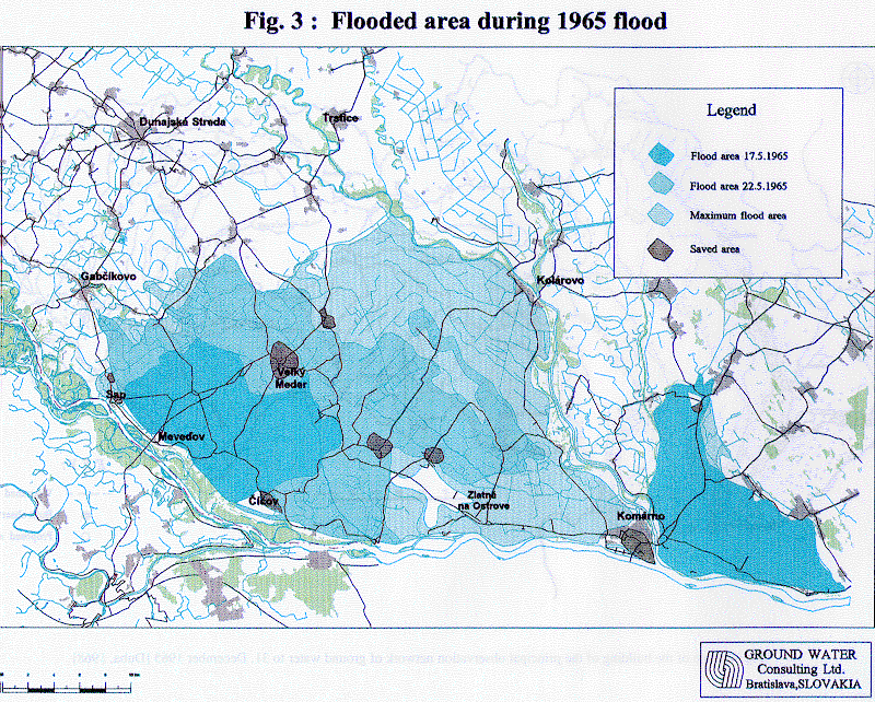
increased the danger of floods in the downstream section. (A large catastrophic flood happened in 1954 with
flooding of the Szigetk"z area, and in 1965 with flooding of the lower part of Zitny ostrov area.) The resulting phenomena
are summarised by the EC Working Group of Independent Experts in its report of 23 November 1992:
-
- "Before the multiple impoundment in the upper Danube catchment areas and the embankment and endikement
in Austria, Slovakia and Hungary the Danube was still a free-flowing braided river with a wide floodplain
that extended far beyond the present dikes. The floodplain absorbed much of the peak floods, which consequently
were slowly rising and long-lasting in most years. Also flow velocities may have been lower than today.
-
- With the past endikements, especially during the last century, flood peaks became steeper and higher, flooding
more frequent but in general with a shorter duration. The original zonation in vegetation towards higher
grounds and associated forests was largely 'diked' out of the system. Most of the higher, no longer flooded
soils, were converted into agricultural lands. Although some remnants of these woods are still existing, especially
on the Hungarian side, the lands in between the dikes were consequently flooded more often and the
river arms flushed and scoured more intensively."
A period of 22 years had elapsed between the first intergovernmental negotiation held by Hungary and Czechoslovakia
and approval of the Project. During this period, many hundreds of research projects were carried out. The stress
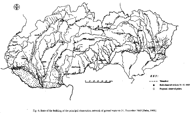
was given mainly on engineering geological and ground water studies. An example of principal studies at the
Comenius University is today's classic textbook "Hydrology of Ground Water" written by Duba and published in
1968, showing, for example, the construction of a system of ground water monitoring wells, the forecasting of ground
water levels, etc.
The Gabcikovo - Nagymaros system, as envisaged by the 1977 Treaty, was a multipurpose project designed to
regulate the usage of the Danube from Bratislava close to Budapest. In addition to the production of the electricity, a
reliable navigation route was to be ensured and protection against floods greatly improved. It was the parties' intention
that the hydroelectric plant at Gabcikovo produce electric power mainly at peak flows, in intervals coinciding
with the peak demands in electricity.
Due to the construction of the bypass canal, it was anticipated that the natural water regime and discharge in the Danube
would change between the Dunakiliti weir and the confluence at Sap. In the upper part of the old Danube riverbed,
underwater weirs were designed to maintain the water level at a level corresponding to the low natural water
level in the Danube in pre-dam conditions. The Danube branches in both Slovak and Hungarian areas would be
dammed up by cascades at several places, to maintain optimal water levels to ensure their revitalisation. Water supply
was ensured by the construction of intake structures inside of the Dunakiliti weir on the Hungarian side and at
Dobrohost on the Slovak side.
The Hungarian decision to abandon the construction of Nagymaros and to suspend the work to be carried out on the
Gabcikovo -Nagymaros project, and later to denounce the treaty, came at a time (on 25. May 1992) when the
work on Czechoslovak territory was more than 90% completed.
In order to minimise the spread of economic and ecological damage, to exploit the available power potential, and to
create conditions necessary for the navigation on the Danube, the Government of the Czech and Slovak Federal Republic
decided in December 1991 to put the nearly ready Gabcikovo part of the system into operation, constructing
the necessary technical means on their own territory and inside of the territory of the construction of the original
Project. These technical means are known as Variant "C". The Variant "C" has a provisional or temporary character
and there exists possibility of returning to the treaty regime. Consideration in this case will be discussed after a decision
of the International Court of Justice, where the case of Gabcikovo-Nagymaros has been submitted.
The implementation of Variant "C" comprises the following works:
- completion of works on the Gabcikovo part of the hydropower structures,
- construction of a new weir complex at Cunovom, on Slovak territory, to create a reservoir,
- construction of dikes connecting the new weir with the bypass canal and with the right side dike on Slovak territory,
- the damming of the Danube and putting the Gabcikovo part of the Project into operation, including navigation via bypass canal,
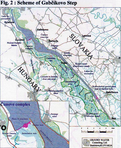
- completion of ancillary structures at Cunovo such as main weir, small hydroelectric power plant, and navigation lock, between the reservoir and the old Danube.
The Gabcikovo Project with the Variant "C" is comprised of the following major structures important for ecological
purposes:
- The intake structure into the Mosoni Danube, originally designed to provide a permanent (and to some extent
variable) water supply of 20 m3/s into the Mosoni Danube, later improved to supply of up to 40 m3/s and even a
bit more. Water is supplyedinto the Mosoni Danube and river branches on Hungarian territory the whole year
(in pre-dam condition approximately 30 days a year).
- An inundation weir, which may be used to direct a part of flood waters into the Danube riverbed and inundation area.
- A bypass weir, designed to channel and regulate flow discharge into the Danube, and to channel ice floes during winter conditions.
- An auxiliary navigation lock, for smaller ships and tourist ships (under construction).
- A weir to release reservoir sediments and to regulate the discharge into the Danube (under construction).
- The hydroelectric power plant at Cunovo (under construction).
- A reservoir with a water level fluctuation of up to 2 metres, raising the surrounding ground water level.
- Seepage canals to channel excess seepage water on both sides of the reservoir (with 2 metres of water level
modification possibilities), to regulate by a reservoir evoked increase of the ground water level, and to ensure the ground water level fluctuation.
- An intake structure into the Maly Danube with discharge regulating gates.
- An intake structure to supply water to the Danube side arms on Slovak territory, taking water from the bypass canal at Dobrohost. The discharge capacity is up to 240 m3/s.
- An intake structure to supply water to the Danube side arms on Hungarian territory directly from the Dunakiliti weir (at present not in use). The discharge capacity is up to 200 m3/s.
- A system of cascades from Dobrohost to Gabcikovo, enabling regulation of water levels in the Slovak side river
branches of up to 2 m. Together with discharge control at Dobrohost, it is possible to inundate the flood plain, to
simulate flood, to remove settled organic material from the main branches, and to control the ground water level
fluctuation in the flood plain.
- Several intake places to supply water for irrigation canals in the Zitny ostrov area, and a system of canals with
gates allowing adjustment of flow direction in canals and water levels.
- The Gabcikovo Hydroelectric Power Station, producing environmentally clean energy (2-2.5 GWh annually)
- and regulating water level in the reservoir.
- A bypass canal, characterised by the EC Working Group of Independent Experts in its report of 23 November 1992:
-
- "In the past, the measures taken for the navigation constrained the possibilities for the development of the Danube
and the floodplain area. Assuming the navigation will no longer use the main river over a length of 40 km a
unique situation has arisen. Supported by technical measures the river and the floodplain can develop more naturally."
All of these managing tools, by which it is possible to optimise use of the surface and ground water for agriculture,
ecology, etc. Some of them are under construction, and some have not been used until now.
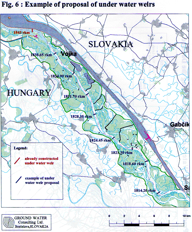
Some other structures are planed or have been constructed. One of them is the underwater weir at rkm 1843, allowing
interconnection and water supply from the Danube to Hungarian river branches, just upstream Dunakiliti.
BASIC CHARACTERISTICS
According to the mutually agreed plan the project Gabcikovo - Nagymaros is hydrologicaly connected to the previously
planned Slovak - Austrian hydroelectric power plant at Wolfsthal, upstream of Bratislava at rkm 1873, and to
the project at Adony, downstream in Hungary at rkm 1601. The technical proposal is in accordance with the concept
of the Rhine-Main-Danube and the Danube-Oder-Elbe navigation system, and with all hydropower stations
and dams on the Danube.
The hydroelectric project consists of two parts: the Gabcikovo project and the Nagymaros project. The Gabcikovo part
of the project is operating in a temporary solution, called Variant C, which was one of seven elaborated temporary
solutions. The aim of this solution was to diminish the enormous damages resulting from the halting of a nearly finished
Gabcikovo part of the project just before its putting into operation. Variant C replaces the function of the Dunakiliti
weir in Hungarian territory with the weir situated inside of the reservoir at Cunovo, in Slovak territory. Variant C
uses all of the completed structures of the Gabcikovo part of the project. The temporary operating solution of
the Gabcikovo project consists of both the original Gabcikovo and the Variant C structures.
Gabcikovo structures are mainly:
- The hydroelectric power station consisting of four blocks in which eight turbines and generators have been installed.
They are all vertical Kaplan turbines, with runners 9.3 m in diameter and a maximum capacity of 90 MW
each. The total installed capacity of the hydropower station is 720 MW with an operational discharge of 4000
m3/s. Minimal and maximal discharges are 413 and 556 m3/s per turbine inversely related to water level differences
of 24.2 and 12.88 m, respectively.
- The two navigation locks which serves passing ships and barges sailing along the Danube. Each lock is 275 m
long and 34 m wide. The difference in water level between the upstream and downstream canals varies from 16
to 23.3 m.
- The bypass canal (diversion, power canal) which is a continuation of the Cunovo reservoir, directs the water
to the power station and serves as a navigation canal. The bypass canal consists of the headwater section upstream
navigation locks, a hydroelectric power station, a the tailwater section (outlet canal) downstream
power station. The bypass canal can handle a flood discharge up to 5300 m3/s. Maximal operational flow velocity
at 4000 m3/s is 1.0 m/s, and will not exceed 1.5 m/s during flood situations.
- The Cunovo reservoir, a part of the original Hrusov-Dunakiliti reservoir, situated exclusively on the Slovak
territory. The area of the originally designed Hrusov-Dunakiliti reservoir is 6000 hectares, and of Variant C
approximately 4000 hectares, according to water level. Operational water level at Cunovo is about 131.1 m
(above the Baltic Sea level), minimal and maximal operational levels are 129 and 131.5 m, respectively.
Navigational depth is 3.5 m.
- The off-take structure at Dobrohost supplies the inundation river branch system with water simulation as
floods for forestry and ecological purposes, e.g., the period needed for laying fish eggs. The discharge capacity is
up to 240 m3/s, according to the water level in the power canal. The off-take structure was put into operation in
May 1993. (Similar off-take structures with capacity 200 m3/s have been constructed in the Dunakiliti weir
for supplying water to the Hungarian river branch system and the inundation area.)
Variant C structures replacing the function of Dunakiliti are mainly:
- The damming of the Danube (the closure of the river bed, the dam across the Danube) at rkm 1851.75 to put
the water power structures into operation, mainly to fill with water the structures of the reservoir, power canal
etc. Damming of the Danube started on 24 October 1992.
- A bypass weir with 4 taintor gates, which serves to pass the water after damming the Danube, to discharge a
sanitary flow into the former river-bed, and to pass the ice floods. A discharge capacity of up to 600 m3/s is in
regular use.
- An inundation weir with 20 taintor gates, which serves to discharge water into the Danube and its inundation
during the flood flows. The structure together with the bypass weir is able to pass a discharge of 6000 m3/s.
- An intake into the Mosoni Danube, with a connection canal with an off-take capacity of about 40 m3/s, according
to hydrological conditions. Structure serves to supply water to the Mosoni Danube and the Hungarian
river branch system at Szigetkoz. A small two turbines hydropower station is installed with a discharge of 20
m3/s and a capacity of 1 MW.
- A hydropower station with a capacity of 52 MW, which can serve to discharge a sanitary flow of up to 400 m3/s
into the old Danube (under construction).
- A central weir with 3 taintor gates, enabling the emptying of the reservoir and the passing of iceblocks, is under
construction. Its discharge capacity is 3300 m3/s
- An auxiliary navigation lock, for both, regular and especially small and sport ships (under construction) 24 m
wide and 175.5 m long, with three gates dividing the lock into two compartments, 125 and 50.5 m long. Such a
solution is suitable for transfer smaller and also regular ships.
Fig. 1. Map of the Danube river
Fig. 2. Map of the Gabcikovo project
Fig. 3. Flood in 1965
Fig. 4. State of the building of the principal observation network of ground water to 31. Dec. 1965 [ ]
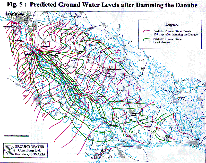
Fig. 5. Forecasted changes of the ground water level caused by construction of hydropower plant Gabcikovo [ ]
Fig. 6. Example of proposal of under water weirs.